
基于电路理论的生态安全格局时空演变与影响因素研究——以陕北黄土高原为例
|
张杰(1996-),男,博士研究生,主要从事生态系统服务与生态安全格局研究. E-mail: 202021009@stumail.nwu.edu.cn |
收稿日期: 2024-03-26
修回日期: 2024-05-13
网络出版日期: 2026-03-11
基金资助
国家自然科学基金资助项目(42171256)
Spatial and temporal evolution and influencing factors of ecological security pattern based on circuit theory: A case of Loess Plateau in northern Shaanxi
Received date: 2024-03-26
Revised date: 2024-05-13
Online published: 2026-03-11
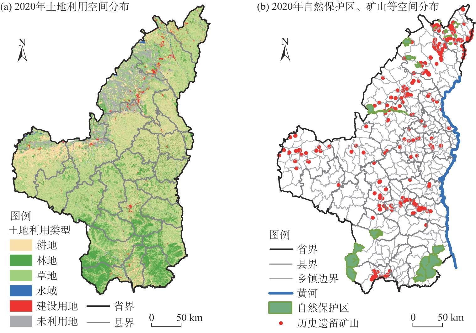
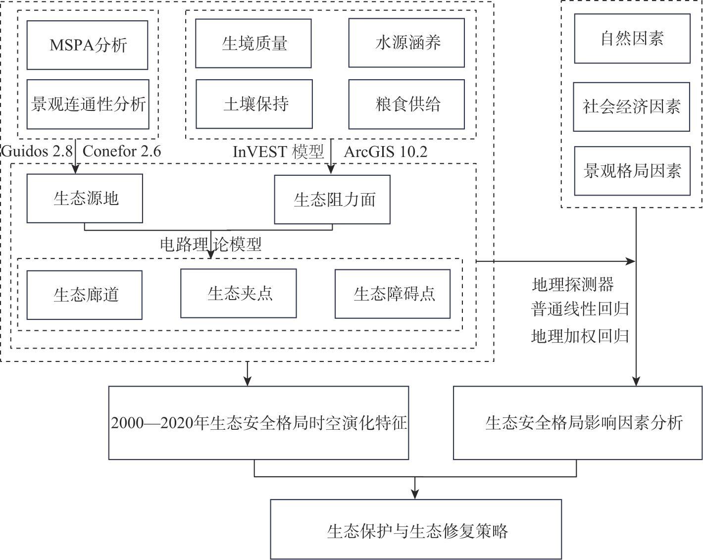
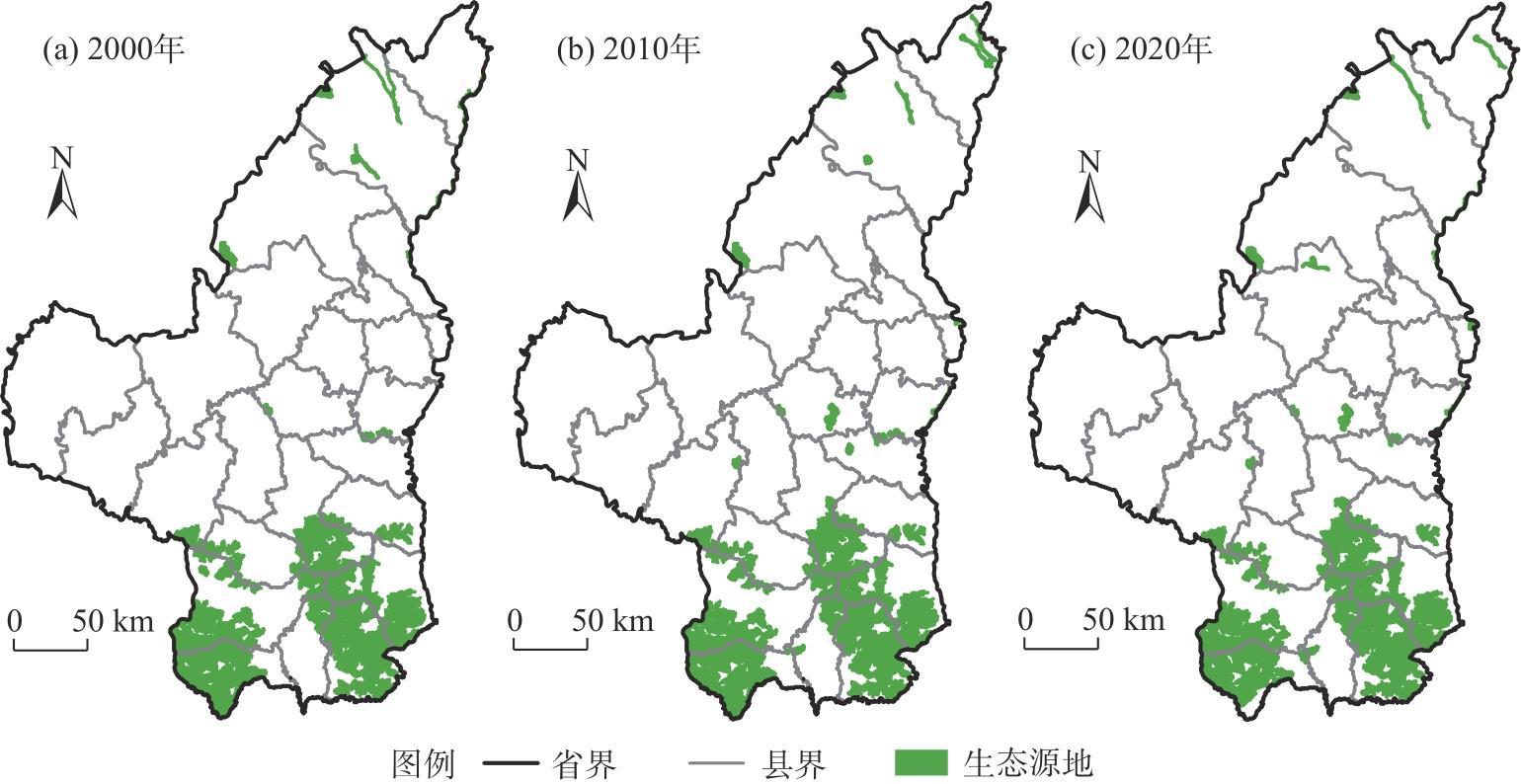
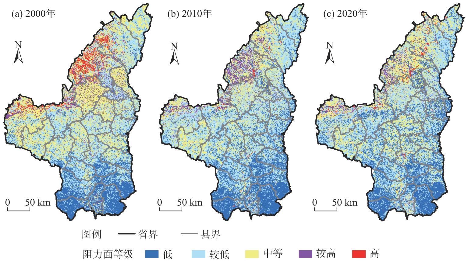
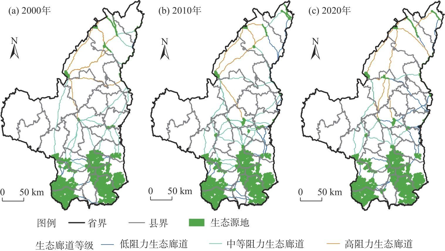
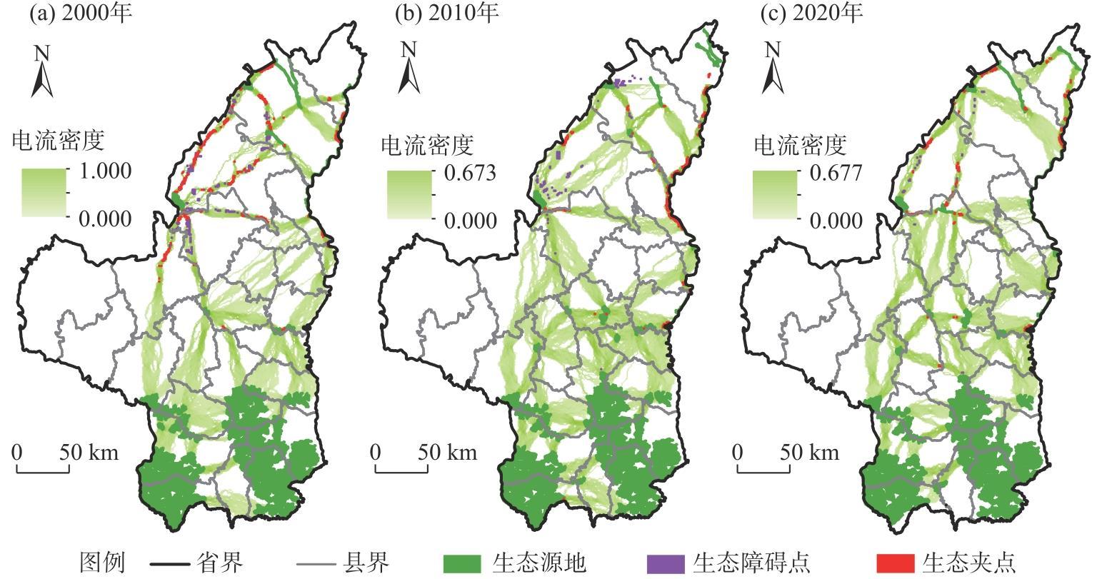
识别对于维护区域生态系统具有重要意义的点、线、面等景观要素,构建动态生态安全格局并探究其影响因素,对于维护区域生态安全具有重要意义。针对以往研究对生态安全格局动态演化和影响因素探究的不足,利用形态空间格局分析(MSPA)、景观连通性分析和电路理论模型等方法,构建2000—2020年陕北黄土高原的生态安全格局,分析其时空演化特征,并利用地理探测器、普通最小二乘法(OLS)和地理加权回归(GWR)模型探究生态安全格局空间异质性的影响因素,并给出生态恢复策略。结果表明:(1) 2000—2020年生态源地在陕北黄土高原南部集中分布,面积变化较小且空间位置较为稳定。(2) 2000、2010年和2020年陕北黄土高原生态阻力面的均值分别为4.96、4.36和4.40,呈现南部低、西北高的空间格局。(3) 2000、2010年和2020年陕北黄土高原生态廊道的长度分别为2416.25 km、3433.61 km和2643.62 km,南部生态廊道密集,以低阻力生态廊道为主,北部生态廊道稀疏,以高阻力生态廊道为主。(4) 生态夹点和生态障碍点主要分布在陕北黄土高原西北部,面积不断减少。(5) 植被覆盖度、景观多样性、人口密度、坡度和降水是影响陕北黄土高原生态安全格局空间异质性的主要因子。研究结果可为陕北黄土高原未来的生态规划提供科学合理的参考和依据,同时有助于生态政策的制定与调整。
张杰 , 屈建军 , 陈海 , 石金鑫 , 马羽赫 , 刘迪 . 基于电路理论的生态安全格局时空演变与影响因素研究——以陕北黄土高原为例[J]. 干旱区地理, 2025 , 48(3) : 494 -505 . DOI: 10.12118/j.issn.1000-6060.2024.199
Identifying landscape elements such as points, lines, and planes that are critical for maintaining regional ecosystems is essential for constructing dynamic ecological security patterns and understanding their influencing factors. Addressing the limitations of previous studies, this research employs morphological spatial pattern analysis (MSPA), landscape connectivity analysis, and circuit theory models to construct ecological security patterns on the Loess Plateau in northern Shaanxi Province, China, from 2000 to 2020. It investigates the temporal and spatial evolution of these patterns and uses geographical detectors, ordinary least squares (OLS), and geographically weighted regression (GWR) models to analyze the spatial heterogeneity of influencing factors, offering ecological restoration strategies. The results showed that: (1) From 2000 to 2020, ecological sources were concentrated in the southern Loess Plateau of northern Shaanxi, with minimal changes in area and stable spatial locations. (2) The mean ecological resistance surface values on the Loess Plateau in northern Shaanxi in 2000, 2010, and 2020 were 4.96, 4.36, and 4.40, respectively, showing a pattern of low resistance in the south region and high resistance in the northwest region. (3) Ecological corridor lengths on the Loess Plateau in northern Shaanxi were 2416.25 km, 3433.61 km, and 2643.62 km in 2000, 2010, and 2020, respectively. Southern regions exhibited dense, low-resistance corridors, while northern regions had sparse, high-resistance corridors. (4) Ecological pinch points and barriers were mainly located in the northwest of the Loess Plateau in northern Shaanxi, with their areas consistently decreasing over time. (5) Vegetation coverage, landscape diversity, population density, slope, and precipitation were the primary factors influencing the spatial heterogeneity of the ecological security pattern. These findings provide a scientific basis for ecological planning on the Loess Plateau in northern Shaanxi, aiding in the development and adjustment of ecological restoration strategies.
图6 2000—2020年陕北黄土高原生态夹点和生态障碍点空间分布Fig. 6 Spatial distributions of ecological pinch points and ecological barriers of Loess Plateau in northern Shaanxi from 2000 to 2020 |
表1 2000—2020年陕北黄土高原生态夹点与生态障碍点的数量与面积Tab. 1 Number and area of ecological pinch points and ecological barriers from 2000 to 2020 |
| 年份 | 生态夹点 | 生态障碍点 | |||
|---|---|---|---|---|---|
| 数量/个 | 面积/km2 | 数量/个 | 面积/km2 | ||
| 2000 | 83 | 395.23 | 70 | 281.91 | |
| 2010 | 44 | 250.22 | 42 | 132.71 | |
| 2020 | 56 | 207.12 | 19 | 33.89 | |
表2 生态源地影响因子OLS测算结果Tab. 2 Results of OLS of ecological source influencing factors |
| 变量 | 系数 | 标准误 | P值 | VIF |
|---|---|---|---|---|
| 高程 | 0.064 | 0.153 | 0.675 | 4.22 |
| 气温 | -1.159 | 0.121 | 0.194 | 4.03 |
| NDVI | 0.263 | 0.082 | 0.005 | 2.28 |
| 夜间灯光强度 | -0.295 | 0.207 | 0.157 | 1.53 |
| 人口密度 | 0.395 | 1.627 | 0.809 | 1.58 |
| SHEI | -0.298 | 0.060 | 0.000 | 1.43 |
注:NDVI为归一化植被指数;SHEI为香农均匀度指数;VIF为方差膨胀因子。下同。 |
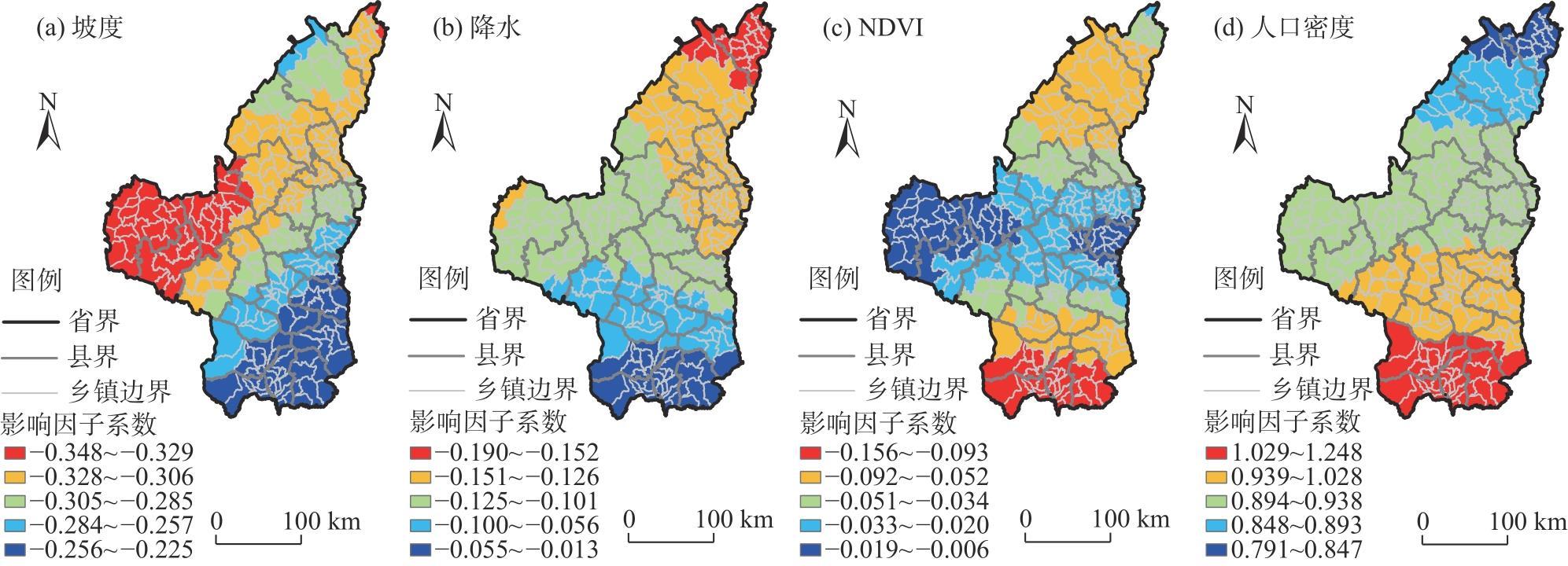
表3 生态阻力面影响因子OLS测算结果Tab. 3 Results of OLS of ecological resistance surface influencing factors |
| 变量 | 系数 | 标准误 | P值 | VIF |
|---|---|---|---|---|
| 坡度 | -0.289 | 0.018 | 0.000 | 1.46 |
| 降水 | -0.117 | 0.014 | 0.000 | 2.37 |
| NDVI | -0.032 | 0.015 | 0.040 | 2.47 |
| 人口密度 | 0.900 | 0.326 | 0.000 | 1.10 |
表4 OLS与GWR模型结果对比Tab. 4 Comparison between OLS and GWR model results |
| 模型 | AICc | R2 | R2 adjusted |
|---|---|---|---|
| GWR | -1154.333 | 0.869 | 0.863 |
| OLS | -1113.966 | 0.843 | 0.841 |
注:GWR为地理加权回归模型;OLS为普通最小二乘法;AICc为赤池信息量准则;R2为拟合优度;R2 adjusted为调整后的拟合优度。 |
| [1] |
|
| [2] |
|
| [3] |
|
| [4] |
|
| [5] |
|
| [6] |
朱炳臣, 李同昇, 陈谢扬, 等. 汉江流域生态综合网络构建与生态安全格局识别研究[J]. 长江流域资源与环境, 2024, 33(2): 362-373.
[
|
| [7] |
叶鑫, 邹长新, 刘国华, 等. 生态安全格局研究的主要内容与进展[J]. 生态学报, 2018, 38(10): 3382-3392.
[
|
| [8] |
彭建, 赵会娟, 刘焱序, 等. 区域生态安全格局构建研究进展与展望[J]. 地理研究, 2017, 36(3): 407-419.
[
|
| [9] |
孙枫, 章锦河, 王培家, 等. 城市生态安全格局构建与评价研究:以苏州市区为例[J]. 地理研究, 2021, 40(9): 2476-2493.
[
|
| [10] |
韩俊宇, 余美瑛. 全域全要素统筹背景下生态安全格局识别与优化建议——以衢州市常山县为例[J]. 地理研究, 2021, 40(4): 1078-1095.
[
|
| [11] |
黄秋淞, 何浩. 耦合生态系统服务和景观连通性的环塔里木盆地绿洲区生态安全格局研究[J]. 干旱区地理, 2024, 47(10): 1745-1754.
[
|
| [12] |
王晓玉, 冯喆, 吴克宁, 等. 基于生态安全格局的山水林田湖草生态保护与修复[J]. 生态学报, 2019, 39(23): 8725-8732.
[
|
| [13] |
李洪庆, 杨瑀, 张俊红. 雅鲁藏布江山南宽谷流域生态安全格局构建[J]. 干旱区地理, 2023, 46(9): 1503-1513.
[
|
| [14] |
王秀明, 赵鹏, 龙颖贤, 等. 基于生态安全格局的粤港澳地区陆域空间生态保护修复重点区域识别[J]. 生态学报, 2022, 42(2): 450-461.
[
|
| [15] |
李恒凯, 刘玉婷, 李芹, 等. 基于MCR模型的南方稀土矿区生态安全格局分析[J]. 地理科学, 2020, 40(6): 989-998.
[
|
| [16] |
姚材仪, 何艳梅, 程建兄, 等. 岷江流域生态安全格局评价与优化——基于最小累积阻力模型和重力模型[J]. 生态学报, 2023, 43(17): 7083-7096.
[
|
| [17] |
潘竟虎, 王云. 基于CVOR和电路理论的讨赖河流域生态安全评价及生态格局优化[J]. 生态学报, 2021, 41(7): 2582-2595.
[
|
| [18] |
崔嵩, 杜显磊, 贾朝阳, 等. 黑龙江省生态系统服务价值估算及其生态安全格局构建[J]. 环境科学, 2024, 45(11): 6489-6500.
[
|
| [19] |
于婧, 汤昪, 陈艳红, 等. 山水资源型城市景观生态风险评价及生态安全格局构建——以张家界市为例[J]. 生态学报, 2022, 42(4): 1290-1299.
[
|
| [20] |
梁坤宇, 金晓斌, 张晓琳, 等. 耦合生态系统服务供需的生态安全格局构建——以苏南地区为例[J]. 生态学报, 2024, 44(9): 3880-3896.
[
|
| [21] |
|
| [22] |
|
| [23] |
|
| [24] |
倪庆琳, 侯湖平, 丁忠义, 等. 基于生态安全格局识别的国土空间生态修复分区——以徐州市贾汪区为例[J]. 自然资源学报, 2020, 35(1): 204-216.
[
|
| [25] |
|
| [26] |
|
| [27] |
石金鑫, 梁小英, 李辉蔷, 等. 陕北黄土高原景观格局对生态系统服务权衡关系的影响[J]. 生态学报, 2023, 43(21): 8958-8972.
[
|
| [28] |
|
| [29] |
|
| [30] |
|
| [31] |
赵文祯, 韩增林, 闫晓露, 等. 基于生态系统服务多情景权衡的生态安全格局构建——以大连市瓦房店为例[J]. 自然资源学报, 2020, 35(3): 546-562.
[
|
| [32] |
潘竟虎, 李磊. 利用OWA和电路模型优化黄河流域甘肃段生态安全格局[J]. 农业工程学报, 2021, 37(3): 259-268.
[
|
| [33] |
|
| [34] |
付凤杰, 刘珍环, 刘海. 基于生态安全格局的国土空间生态修复关键区域识别——以贺州市为例[J]. 生态学报, 2021, 41(9): 3406-3414.
[
|
| [35] |
冯琰玮, 甄江红, 田桐羽. 基于生态安全格局的国土空间保护修复优化——以内蒙古呼包鄂地区为例[J]. 自然资源学报, 2022, 37(11): 2915-2929.
[
|
| [36] |
卫新东, 林良国, 冯小龙, 等. 神木市生态安全格局构建与生态问题定量诊断[J]. 生态学报, 2023, 43(1): 82-94.
[
|
| [37] |
覃彬桂, 林伊琳, 赵俊三, 等. 基于InVEST模型和电路理论的昆明市国土空间生态修复关键区域识别[J]. 中国环境科学, 2023, 43(2): 809-820.
[
|
| [38] |
王劲峰, 徐成东. 地理探测器:原理与展望[J]. 地理学报, 2017, 72(1): 116-134.
[
|
| [39] |
|
| [40] |
彭建, 李慧蕾, 刘焱序, 等. 雄安新区生态安全格局识别与优化策略[J]. 地理学报, 2018, 73(4): 701-710.
[
|
| [41] |
李婷, 董玉祥. 基于RSEI和景观功能的珠三角地区1986—2019年生态安全格局演变过程及其影响因子[J]. 陕西师范大学学报(自然科学版), 2022, 50(4): 69-80.
[
|
| [42] |
|
| [43] |
李彤, 贾宝全, 刘文瑞, 等. 宜昌市生态安全网络要素时空动态及其影响因素[J]. 生态学报, 2023, 43(15): 6154-6169.
[
|
| [44] |
|
| [45] |
朱炳臣, 李同昇, 朱小青, 等. 基于生态网络优化的生态保护重要性评价——以陕西省为例[J]. 农业资源与环境学报, 2023, 40(6): 1480-1493.
[
|
| [46] |
杨文越, 叶泓妤. 基于生境质量的粤港澳大湾区生态网络识别[J]. 生态学报, 2023, 43(24): 10430-10442.
[
|
| [47] |
赵菊花, 杨永崇, 王涛, 等. 黄土高原2000—2020年生态网络演变及关键修复区识别[J]. 测绘通报, 2023(8): 19-23, 77.
[
|
/
| 〈 |
|
〉 |