
约束与增长双向引导的黄土丘陵沟壑区县城“三生”空间优化——以米脂县城中心城区为例
|
贾若楠(1994-),女,博士研究生,主要从事国土空间规划等方面的研究. E-mail: jrndyx@163.com |
收稿日期: 2024-04-29
修回日期: 2024-08-27
网络出版日期: 2026-03-11
基金资助
国家重点研发计划课题(2022YFC3802803)
国家自然科学基金项目(52178055)
Optimization of “ecological-production-living” spaces for urban areas in Loess Plateau hilly and gully region by the dual-guidance between constraints and growth: A case of the central urban area of Mizhi County
Received date: 2024-04-29
Revised date: 2024-08-27
Online published: 2026-03-11
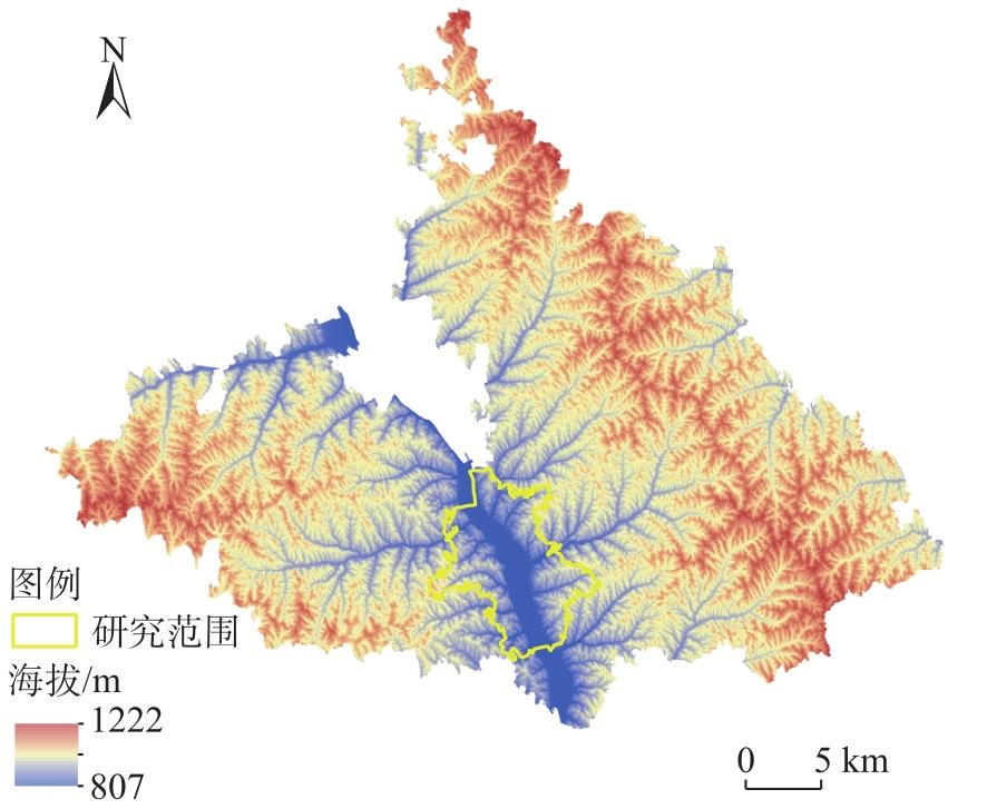
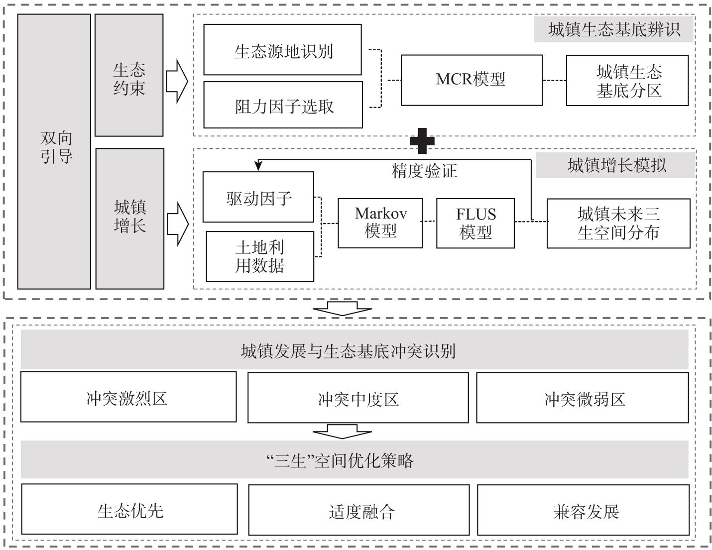
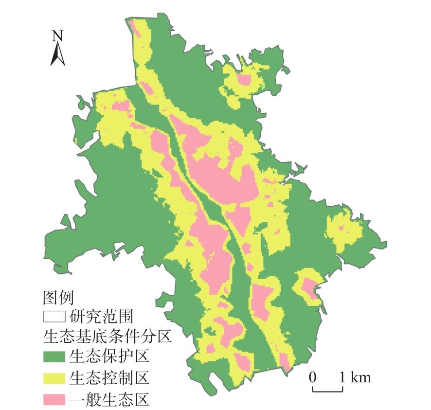
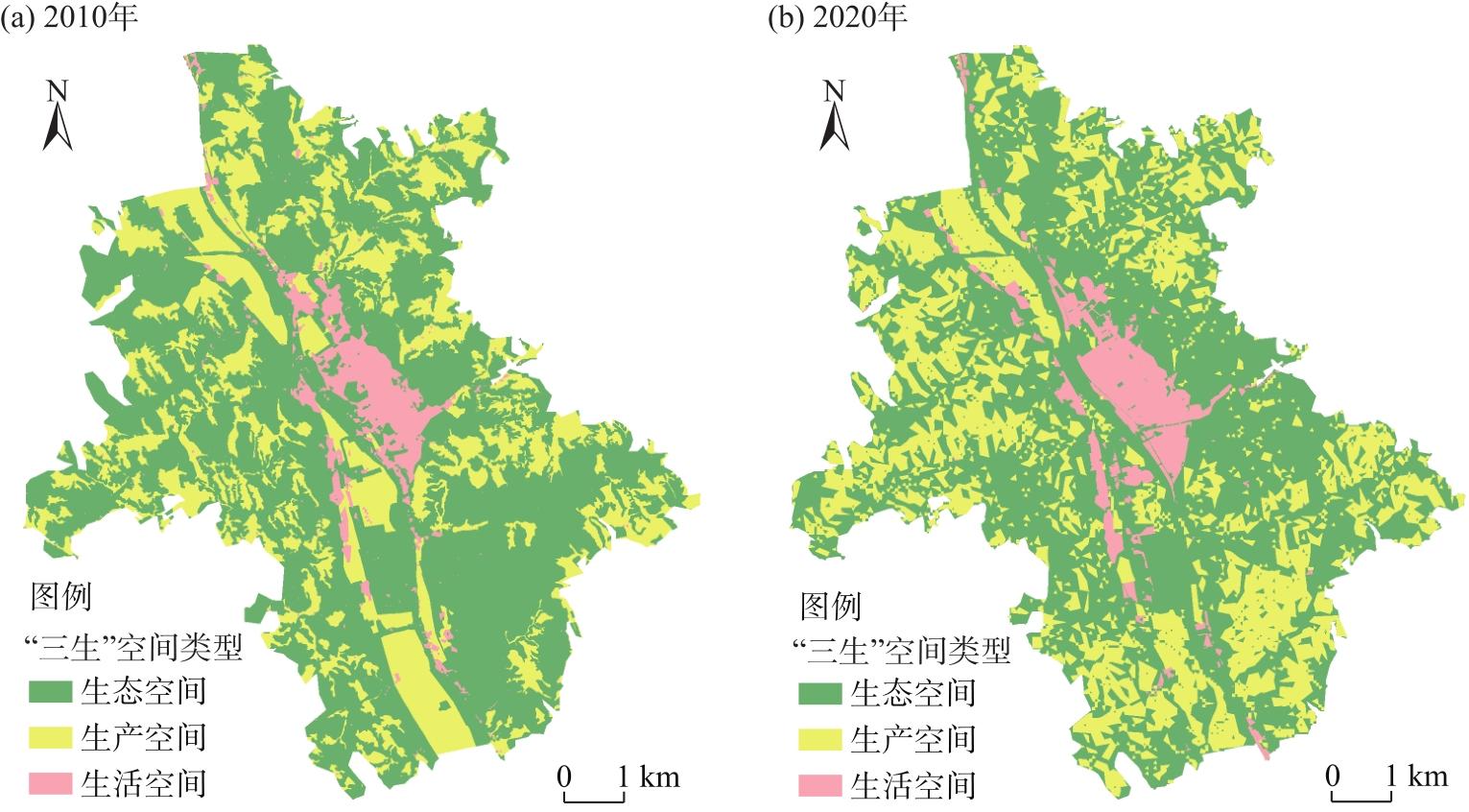
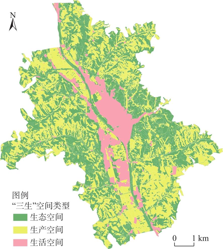
在黄土丘陵沟壑区生态本底强约束及城镇发展需求日益增长的背景下,探讨“三生”空间优化为促进该地区资源合理配置提供参考。基于黄土丘陵沟壑区生态约束与城镇增长的双向引导,提出生态基底辨识与城镇增长模拟相结合的集成性研究方法。以米脂县城中心城区为例,采用MCR模型评价中心城区生态基底条件,利用FLUS-Markov模型模拟2035年中心城区“三生”空间分布,基于此识别生态基底条件与2035年“三生”空间分布的冲突激烈区、冲突中度区与冲突微弱区,并对各冲突区域提出优化策略。结果表明:(1) 米脂县城中心城区生态基底条件划分为3个等级:生态保护区、生态控制区和一般生态区,其中生态保护区面积最大,一般生态区面积最小。(2) 2035年自然发展情景下米脂县城中心城区生态空间面积减少803.33 hm2,生产与生活空间面积均呈增长态势,增长面积分别为612.03 hm2、191.30 hm2。(3) 米脂县城中心城区有40.80%的用地在未来存在冲突风险,冲突激烈区面积1606.54 hm2,约占城区的23.29%,冲突中度区面积968.19 hm2,约占城区的14.04%,冲突微弱区面积239.32 hm2,约占城区的3.47%,针对各冲突分区特点,提出生态优先、适度融合和兼容发展的“三生”空间优化策略。
贾若楠 , 吴左宾 . 约束与增长双向引导的黄土丘陵沟壑区县城“三生”空间优化——以米脂县城中心城区为例[J]. 干旱区地理, 2025 , 48(2) : 333 -344 . DOI: 10.12118/j.issn.1000-6060.2024.268
In the context of stringent ecological constraints in the Loess Plateau hilly and gully region and the growing demand for urban development, optimizing ecological-production-living (EPL) spaces is crucial for promoting the rational allocation of resources. This study employs an integrated research method combining ecological base identification with urban growth simulation, guided by ecological constraints and urban growth patterns in the Loess Plateau hilly and gully region. Using the central urban area of Mizhi County, Shaanxi Province, China as a case study, the ecological base conditions were evaluated using the minimum cumulative resistance (MCR) model. The Markov and FLUS models were applied to simulate the spatial distribution of EPL spaces in the urban area for 2035. Subsequently, intense, moderate, and weak conflict zones between ecological base conditions and the spatial distribution of EPL spaces in 2035 were identified, and optimization strategies were proposed for each conflicting zone. The results revealed the following: (1) The ecological base conditions in Mizhi County were categorized into three levels: ecological protection area, ecological control area, and general ecological area, with ecological protection area being the largest and general ecological area the smallest. (2) By 2035, ecological space is projected to decrease by 803.33 hm2, while production and living spaces are expected to increase by 612.03 hm2 and 191.30 hm2, respectively. (3) Approximately 40.80% of the land in the central urban area of Mizhi County is at risk of conflict. Intense conflict zones account for 1606.54 hm2, or 23.29% of the urban area; moderate conflict zones account for 968.19 hm2, or 14.04%; and weak conflict zones account for 239.32 hm2, or 3.47%. Based on the characteristics of each conflict zone, the study proposes EPL space optimization strategies focusing on ecological priority, moderate integration, and compatible development. The integrated research method presented in this study, which combines ecological base identification with urban growth simulation, demonstrates high applicability to the Loess Plateau hilly and gully region and offers valuable insights for the future optimization of EPL spaces in this area.
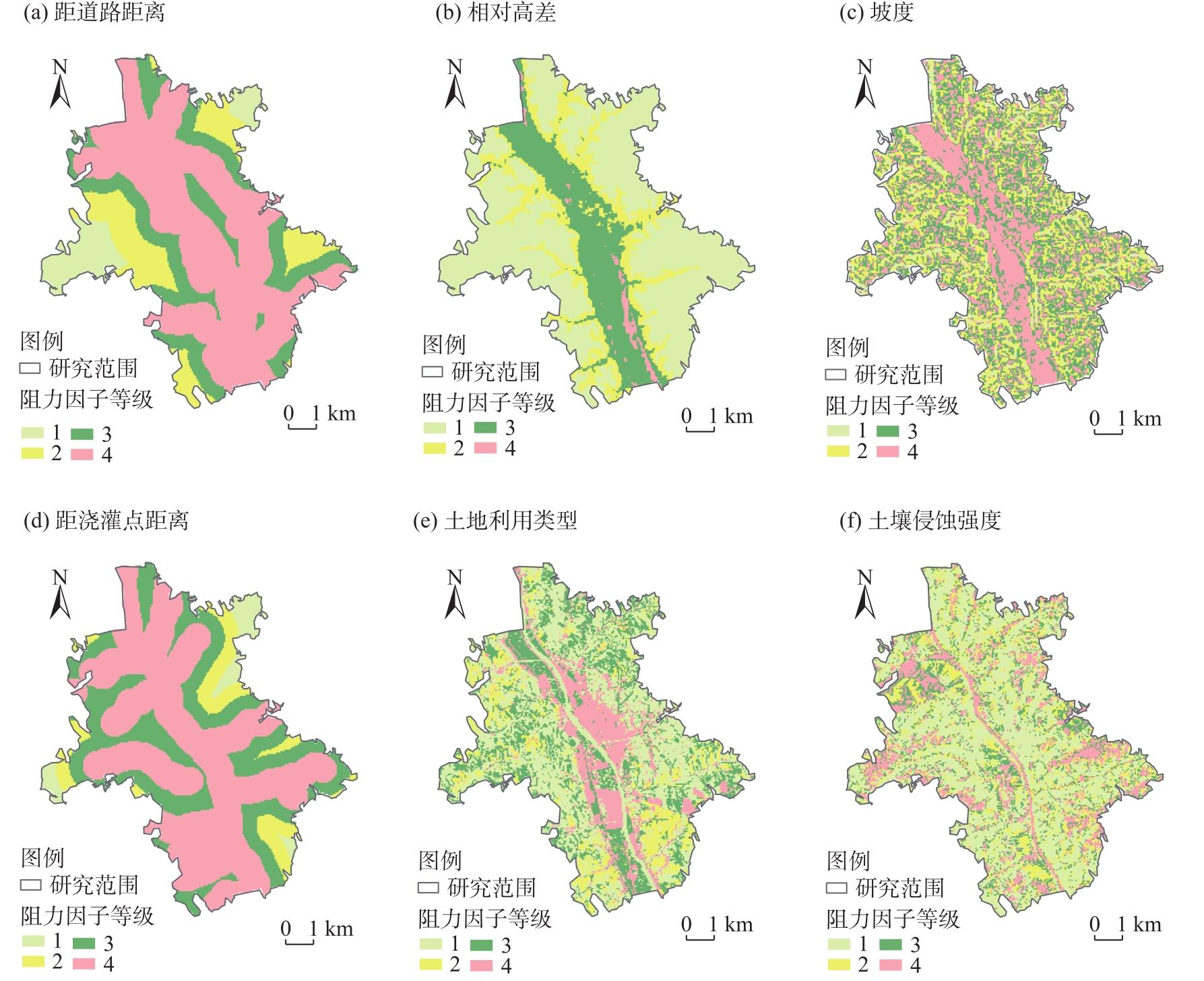
表1 生态用地阻力因子Tab. 1 Ecological land use resistance factors |
| 生态阻力因子 | 阻力因子分级 | 权重 | ||||
|---|---|---|---|---|---|---|
| 4 | 3 | 2 | 1 | |||
| 自然 | 相对高差/m | <50 | 50~100 | 100~150 | >150 | 0.05 |
| 坡度/(°) | 0~8 | 8~15 | 15~25 | >25 | 0.19 | |
| 区位 | 距道路距离/m | <100 | 100~250 | 250~500 | >500 | 0.15 |
| 距浇灌点距离/m | <500 | 500~1000 | 1000~1500 | >1500 | 0.14 | |
| 现状 | 土地利用类型 | 建设用地 | 耕地 | 园地 | 草地、林地、河流水面 | 0.18 |
| 土壤侵蚀强度/t·km-2·a-1 | <1000 | 1000~2500 | 2500~5000 | >5000 | 0.29 | |
表2 土地利用变化的驱动因子Tab. 2 Drivers of land use change |
| 类型 | 驱动因子 |
|---|---|
| 自然要素 | 相对高差 |
| 坡度 | |
| 坡向 | |
| 到河流水系距离 | |
| 土壤侵蚀强度 | |
| 社会要素 | 到铁路距离 |
| 到公路距离 | |
| 到汽车站、停车场的距离 | |
| 人口密度 |
表3 邻域因子参数Tab. 3 Neighborhood factor parameter |
| 邻域因子参数 | 生态空间 | 生产空间 | 生活空间 |
|---|---|---|---|
| 数值 | 0.2 | 0.5 | 1.0 |
表4 空间变化转换矩阵Tab. 4 Spatial change transformation matrix |
| “三生”空间类型 | 生态空间 | 生产空间 | 生活空间 |
|---|---|---|---|
| 生态空间 | 1 | 1 | 1 |
| 生产空间 | 1 | 1 | 1 |
| 生活空间 | 1 | 1 | 1 |
图6 2035年“三生”空间预测结果Fig. 6 Prediction results of ecological-production-living spaces in 2035 |
表5 “三生”空间面积变化情况Tab. 5 Change of the area of ecological-production-living spaces /hm2 |
| “三生”空间类型 | 2020年 | 2035年 |
|---|---|---|
| 生态空间 | 3887.56 | 3084.23 |
| 生产空间 | 2442.19 | 3054.22 |
| 生活空间 | 568.48 | 759.78 |
| [1] |
韩株桃, 石杰锋, 吴金华, 等. 基于POI数据及四叉树思想的“三生空间”识别方法[J]. 地球信息科学学报, 2022, 24(6): 1107-1119.
[
|
| [2] |
王庆, 王承武. 大数据视角下的城市“三生”空间识别及分布特征研究——以乌鲁木齐市中心城区为例[J]. 资源开发与市场, 2022, 38(2): 142-147.
[
|
| [3] |
焦庚英, 杨效忠, 黄志强, 等. 县域“三生空间”格局与功能演变特征及可能影响因素分析——以江西婺源县为例[J]. 自然资源学报, 2021, 36(5): 1252-1267.
[
|
| [4] |
马彩虹, 安斯文, 文琦, 等. 基于土地利用转移流的国土空间格局演变及其驱动机制研究——以宁夏原州区为例[J]. 干旱区地理, 2022, 45(3): 925-934.
[
|
| [5] |
黄金川, 林浩曦, 漆潇潇. 面向国土空间优化的三生空间研究进展[J]. 地理科学进展, 2017, 36(3): 378-391.
[
|
| [6] |
刘荣增, 文慧敏, 王淑华. 郑州都市圈空间分区及优化研究——基于“三生”空间功能评价[J]. 城市发展研究, 2023, 30(3): 1-6, 23.
[
|
| [7] |
翟玉鑫, 张飞云, 马丽娜. 基于三生空间的博斯腾湖流域生境质量时空演变及预估[J]. 干旱区地理, 2023, 46(11): 1792-1802.
[
|
| [8] |
陈小卉, 胡剑双. 江苏省乡村空间治理实践: 阶段、路径与模式[J]. 城市规划学刊, 2024(1): 38-45.
[
|
| [9] |
代秀龙, 赵家敏. 流域生态单元视角下全域土地综合整治路径——以广东省佛冈县汤塘镇省级试点为例[J]. 规划师, 2024, 40(1): 83-90.
[
|
| [10] |
李阜鹏, 韩惠, 杨树文. 甘肃省2000—2020年土地利用变化分析及基于PLUS的生态空间多情景模拟[J]. 科学技术与工程, 2023, 23(15): 6316-6326.
[
|
| [11] |
赵寿露, 李石华, 许新惠, 等. 耦合MOP-FLUS模型的滇中城市群“三生”空间格局优化[J]. 水土保持研究, 2022, 29(4): 322-328.
[
|
| [12] |
付晶莹, 郜强, 江东, 等. 黑土保护与粮食安全背景下齐齐哈尔市国土空间优化调控路径[J]. 地理学报, 2022, 77(7): 1662-1680.
[
|
| [13] |
孙逊, 马乃喜, 曹明明, 等. 黄土高原志[M]. 西安: 陕西人民出版社, 1995: 1-19.
[
|
| [14] |
罗紫薇, 胡希军, 韦宝婧, 等. 基于多准则CA-Markov模型的城市景观格局演变与预测——以上杭县城区为例[J]. 经济地理, 2020, 40(10): 58-66.
[
|
| [15] |
|
| [16] |
俞孔坚. 生物保护的景观生态安全格局[J]. 生态学报, 1999, 19(1): 8-15.
[
|
| [17] |
张继平, 乔青, 刘春兰, 等. 基于最小累积阻力模型的北京市生态用地规划研究[J]. 生态学报, 2017, 37(19): 6313-6321.
[
|
| [18] |
李嘉会, 吴金华, 王祯, 等. 黄土丘陵沟壑区农村居民点发展类型识别——以吴起县为例[J]. 干旱区地理, 2023, 46(3): 397-406.
[
|
| [19] |
靳含, 杨爱民, 夏鑫鑫, 等. 基于CA-Markov模型的多时间跨度土地利用变化模拟[J]. 干旱区地理, 2019, 42(6): 1415-1426.
[
|
| [20] |
高周冰, 王晓瑞, 隋雪艳, 等. 基于FLUS和InVEST模型的南京市生境质量多情景预测[J]. 农业资源与环境学报, 2022, 39(5): 1001-1013.
[
|
| [21] |
何苏玲, 贺增红, 潘继亚, 等. 基于多模型的县域土地利用/土地覆盖模拟[J]. 自然资源遥感, 2023, 35(4): 201-213.
[
|
| [22] |
罗紫元, 曾坚. 资源环境保护下天津市用地空间增长模拟[J]. 地理研究, 2022, 41(2): 341-357.
[
|
| [23] |
苏迎庆, 刘庚, 赵景波, 等. 基于FLUS模型的汾河流域生态空间多情景模拟预测[J]. 干旱区研究, 2021, 38(4): 1152-1161.
[
|
| [24] |
李井浩, 柳书俊, 王志杰. 基于FLUS和InVEST模型的云贵高原土地利用与生态系统服务时空变化多情景模拟研究[J]. 水土保持研究, 2024, 31(3): 287-298.
[
|
| [25] |
任胤铭, 刘小平, 许晓聪, 等. 基于FLUS-InVEST模型的京津冀多情景土地利用变化模拟及其对生态系统服务功能的影响[J]. 生态学报, 2023, 43(11): 4473-4487.
[
|
| [26] |
|
| [27] |
胡佶熹, 勒先文, 徐勇. 基于FLUS模型多情景土地利用变化对陆地生态系统碳储量影响——以江西萍乡为例[J]. 水土保持研究, 2024, 31(2): 299-309.
[
|
| [28] |
王保盛, 廖江福, 祝薇, 等. 基于历史情景的FLUS模型邻域权重设置——以闽三角城市群2030年土地利用模拟为例[J]. 生态学报, 2019, 39(12): 4284-4298.
[
|
/
| 〈 |
|
〉 |
