
|
牛飞飞(2000-),女,硕士研究生,主要从事生态遥感和碳汇研究. E-mail: niufeifei@stu.xju.edu.cn |
收稿日期: 2025-02-24
修回日期: 2025-04-11
网络出版日期: 2026-03-11
基金资助
自治区重点研发项目(2022B01012-2)
国家自然科学基金(52460030)
自治区林业发展补助资金项目(XJLYKJ-2023-20)
Simulation of land use change and prediction of carbon storage in Xinjiang based on GeoSOS-FLUS and InVEST models
Received date: 2025-02-24
Revised date: 2025-04-11
Online published: 2026-03-11
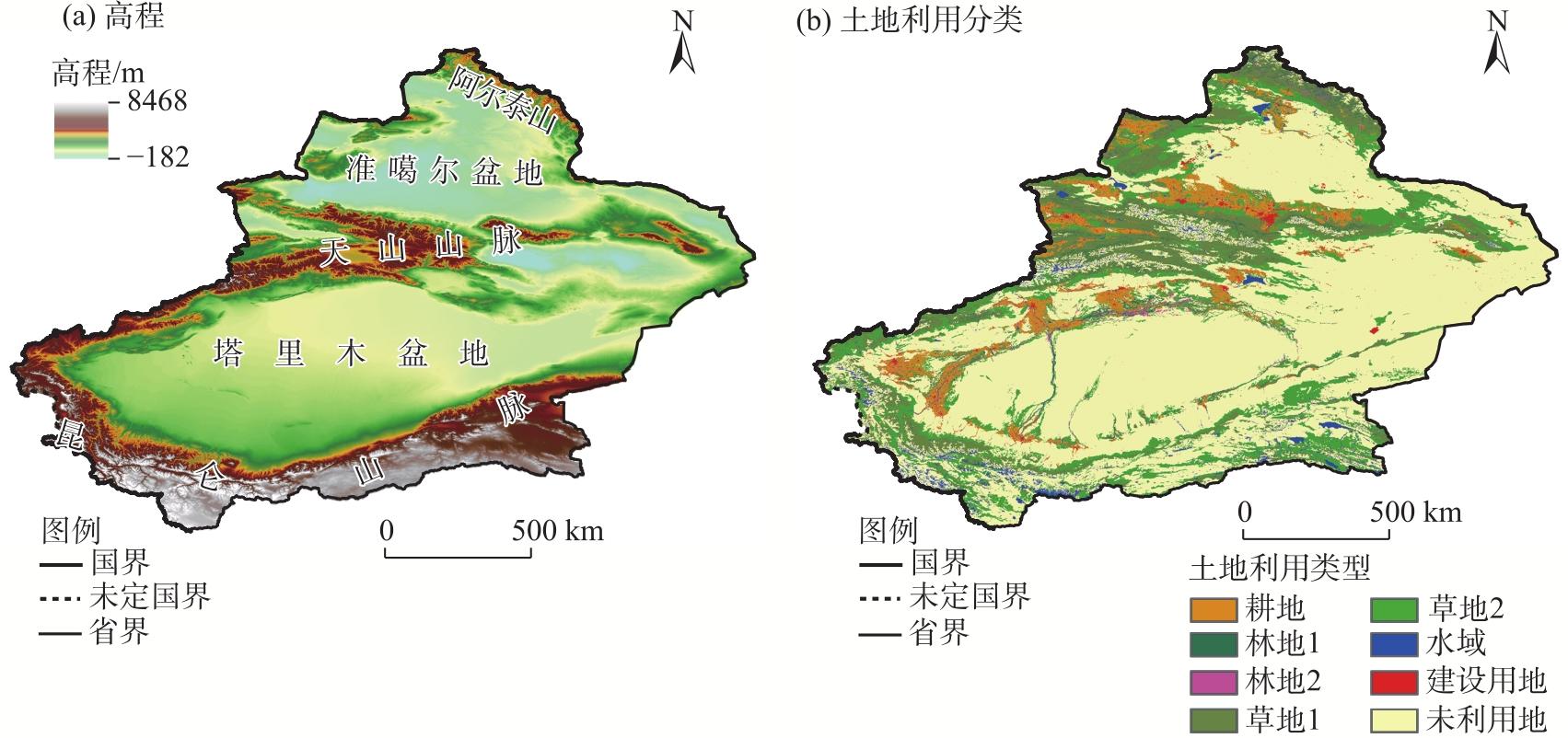
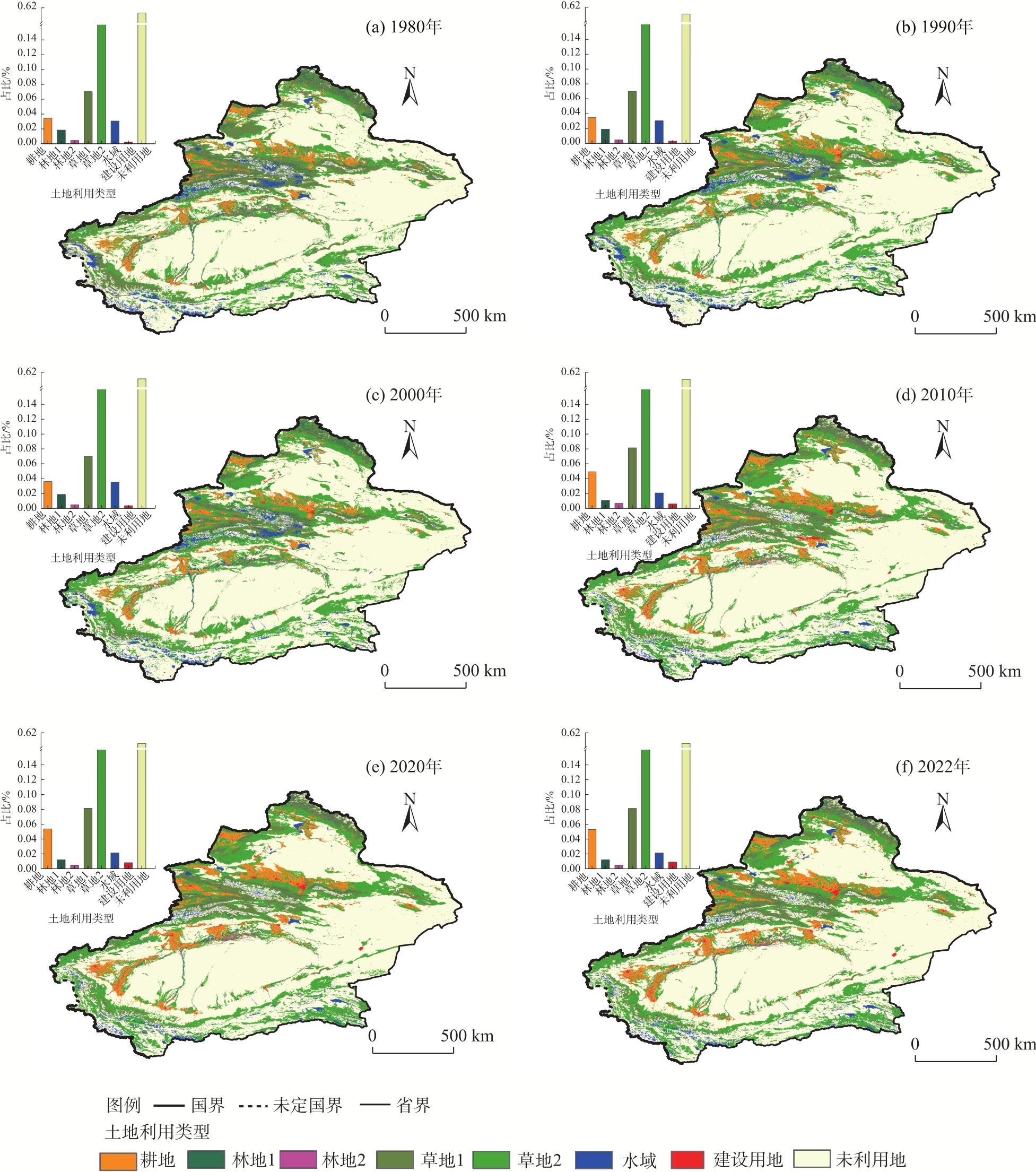
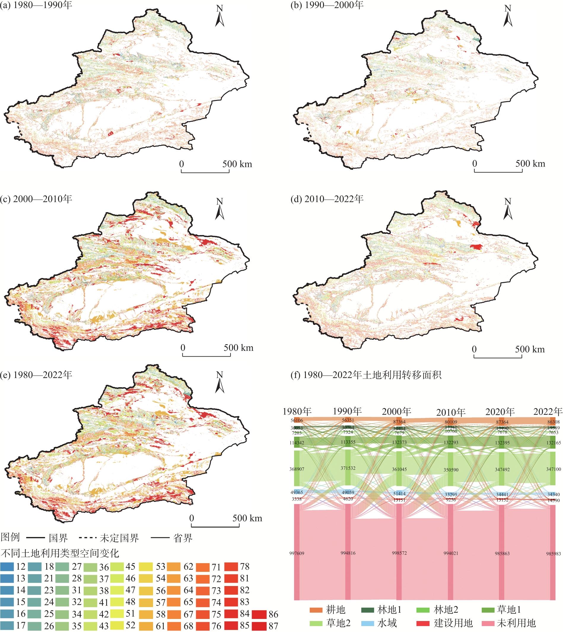
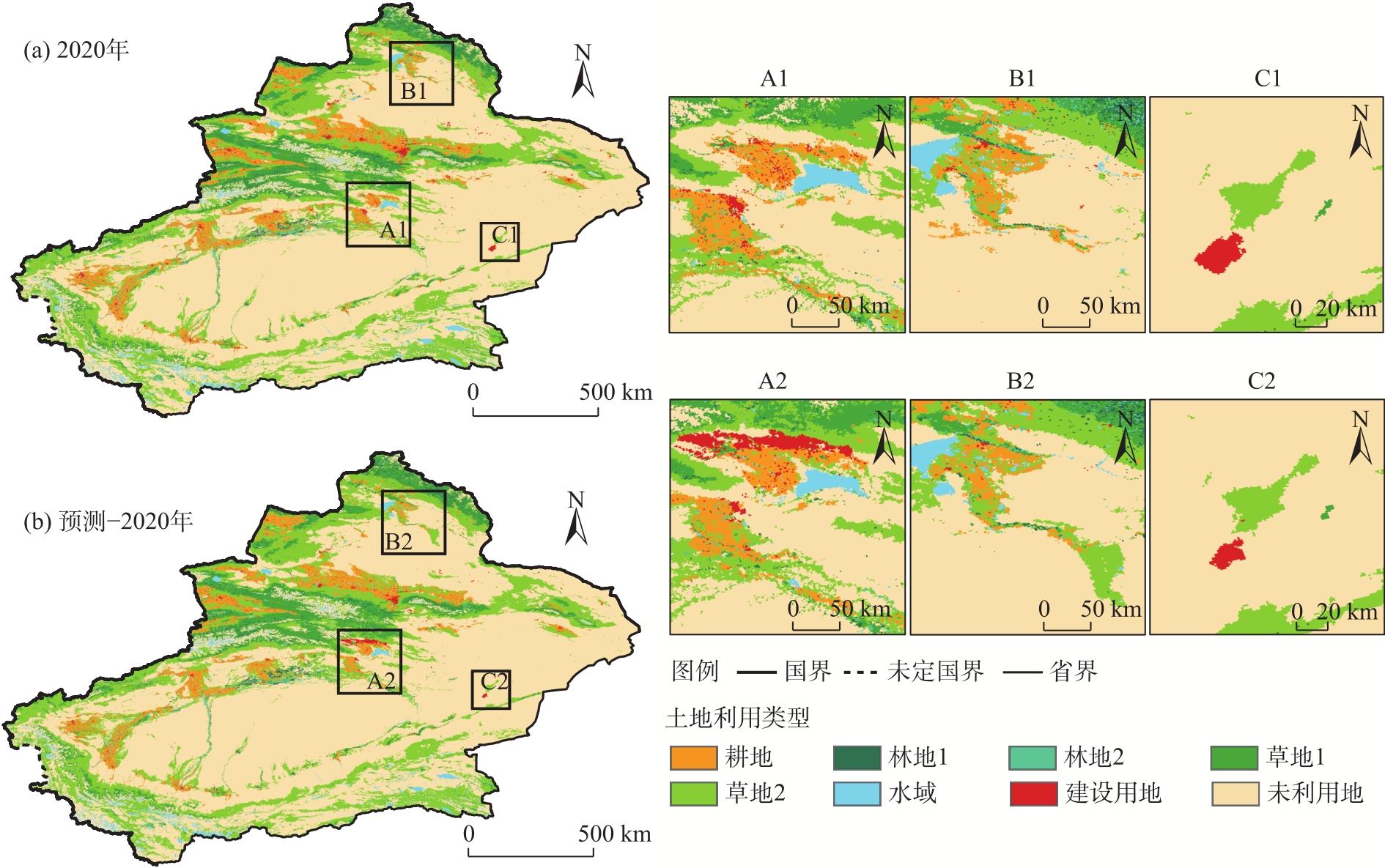
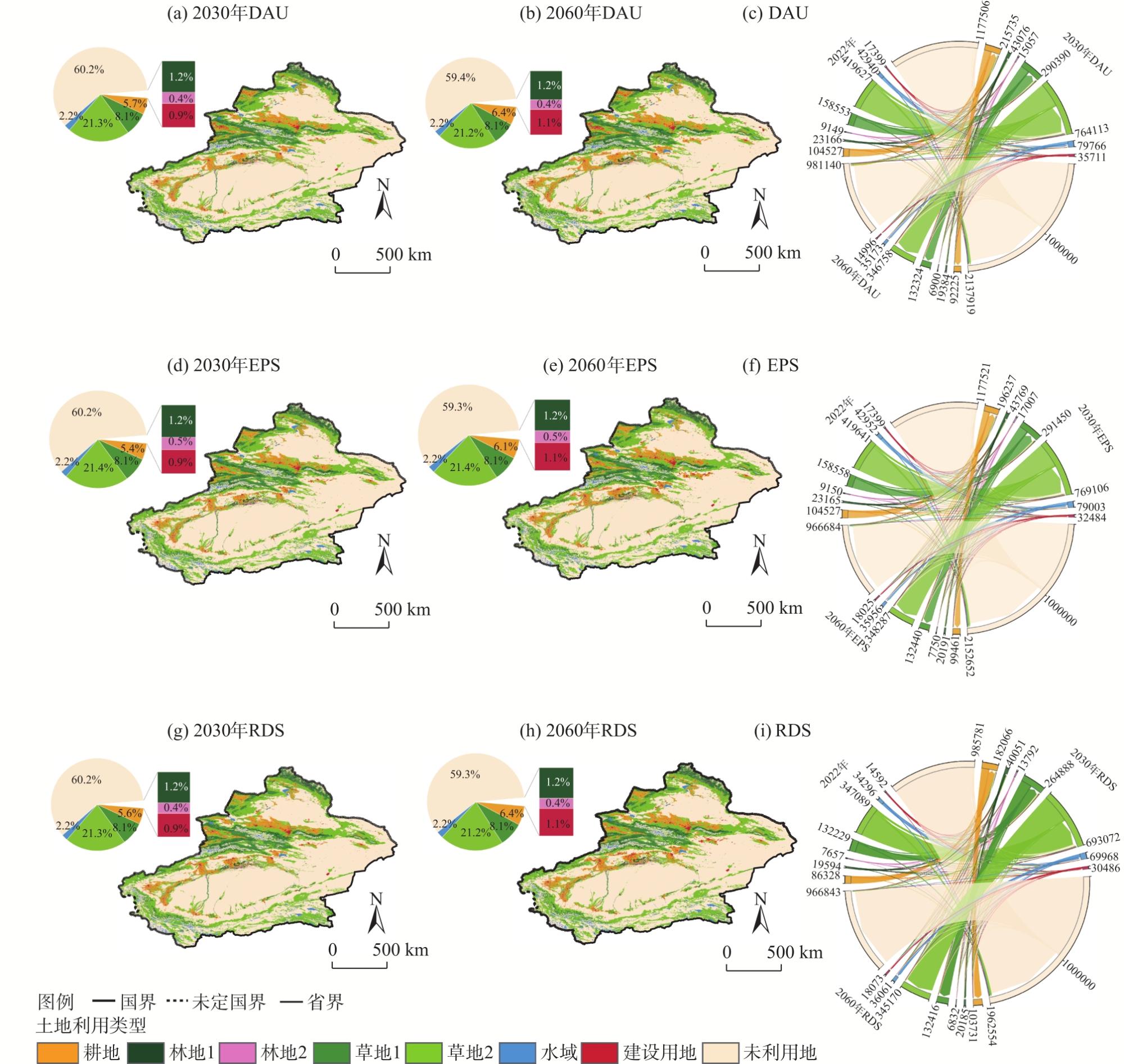
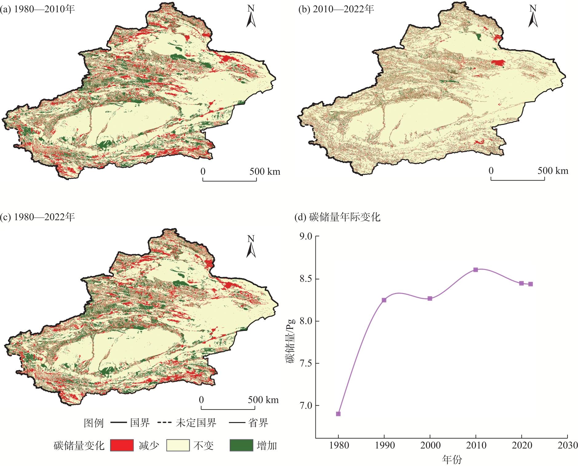
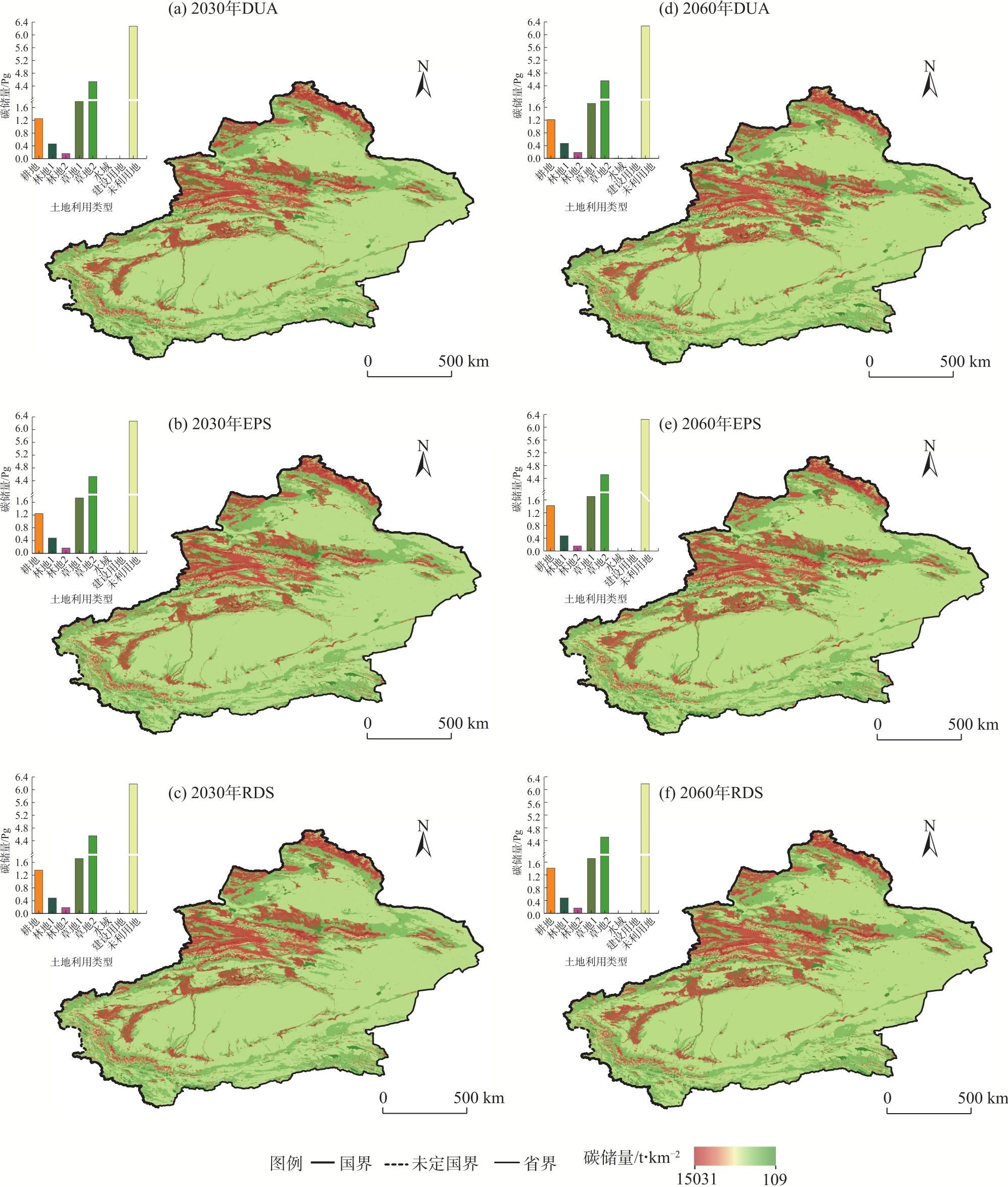
碳储量在陆地生态系统中扮演者重要角色,而土地利用变化是影响区域生态系统碳循环和储存功能的重要因素之一。以新疆为研究区,基于1980—2022年土地利用数据,耦合GeoSOS-FLUS和InVEST模型,分析了1980—2022年新疆土地利用和碳储量变化,并模拟了2030年和2060年在自然发展情景、生态保护情景和快速发展情景下的土地利用和碳储量变化。结果表明:(1) 1980—2022年新疆土地类型占比最多的为未利用地类,耕地、郁闭度<30%的林地、覆盖度>20%的草地、建设用地的总面积增加,郁闭度>30%的林地和灌木林、覆盖度<20%的草地、水域、未利用地面积减少。(2) 2030—2060年除未利用地之外,耕地和草地依旧是主要的土地利用类型。(3) 1980—2022年碳储量以2010年为节点,呈现先升高后降低的趋势,建设用地扩张和林草地退化、水域缩减是碳储量减少的主要原因。(4) 2030—2060年新疆地区碳储量高值区域主要分布在阿尔泰山、天山山脉和塔里木盆地北缘,生态优先情景高于自然发展情景和快速发展情景下的碳储量。研究结果有助于指导新疆地区土地格局调整与碳储存能力优化管理,对实现区域“双碳”目标具有重要意义。
关键词: 碳储量; 土地利用; GeoSOS-FLUS模型; InVEST模型; 新疆
牛飞飞 , 郭靖 , 罗杰 , 勾雪平 , 刘雪薇 , 张仁平 . 基于GeoSOS-FLUS和InVEST模型的新疆地区土地利用变化模拟及碳储量预测[J]. 干旱区地理, 2025 , 48(12) : 2169 -2182 . DOI: 10.12118/j.issn.1000-6060.2025.090
Carbon storage plays an crucial role in terrestrial ecosystems. The change of land use is one of the key factors influencing the carbon cycle and carbon storage in regional ecosystems. This study focuses on Xinjiang as the research area, utilizing land use data from 1980 to 2022 and coupling the GeoSOS-FLUS and InVEST models to analyze the changes in land use and carbon storage in Xinjiang from 1980 to 2022. Additionally, the study simulates changes in land use and carbon storage under three scenarios, namely, the natural development scenario (DAU), ecological protection scenario (EPS), and rapid development scenario (RDS), for the years 2030 and 2060. The results show that: (1) From 1980 to 2022, unused land accounted for the largest proportion of land types in Xinjiang, and the total area of cultivated land, forest land with <30% canopy density, grassland with >20% coverage, and construction land increased. In contrast, forest land with >30% canopy density and woodlands, grassland with <20% coverage, water bodies, and unused land decreased. (2) Excluding unused land, during the period from 2030 to 2060, farmland and grassland remained the dominant land use types. (3) From 1980 to 2022, carbon storage initially increased, followed by a decrease, with 2010 as the turning point. The expansion of construction land, degradation of forest and grassland, and reduction of water bodies were the main contributors to the decline in carbon storage. (4) From 2030 to 2060, the high-value areas of carbon storage in Xinjiang were primarily distributed in the Altai Mountains, Tianshan Mountains, and the northern edge of the Tarim Basin. Under the EPS, carbon storage was higher than that under the natural development and rapid development scenarios. The research findings are expected to contribute to guiding adjustments in land use patterns and optimizing the management of carbon storage in the Xinjiang region, significantly facilitating the achievement of regional “dual carbon” goals.
Key words: carbon storage; land use change; GeoSOS-FLUS model; InVEST model; Xinjiang
表1 数据来源Tab. 1 Data sources |
| 数据类型 | 数据名称 | 格式 | 分辨率 | 数据来源 |
|---|---|---|---|---|
| LUCC | 土地利用数据 | 栅格 | 1 km | 地球资源数据云平台(www.gis5g.com) |
| 地形 | 高程 | 栅格 | 90 m | http://srtm.csi.cgiar.org |
| 坡度 | 栅格 | 90 m | ||
| 坡向 | 栅格 | 90 m | ||
| 植被 | 植被覆盖率 | 栅格 | 1 km,300 m | https://land.copernicus.eu/en |
| 气象数据 | 年均气温 | 栅格 | 1 km | https://data.tpdc.ac.cn |
| 年均降水 | 栅格 | 1 km | https://data.tpdc.ac.cn | |
| 社会经济数据 | 年GDP | 栅格 | 1 km | https://www.resdc.cn |
| 人口密度 | 栅格 | 1 km | https://www.geodata.cn | |
| 区位因素数据 | 距河流、铁路、道路、城镇、市中心、高速的距离 | 栅格 | 30 m | https://www.openstreetmap.org |
注:LUCC为土地利用/覆盖变化。 |
表2 新疆各类土地利用邻域因子Tab. 2 Weight of neighborhood for each land use type in Xinjiang |
| 指标 | 耕地 | 林地1 | 林地2 | 草地1 | 草地2 | 水域 | 建设用地 | 未利用地 |
|---|---|---|---|---|---|---|---|---|
| 领域因子 | 0.5 | 0.7 | 0.5 | 0.6 | 0.4 | 0.4 | 0.8 | 0.1 |
表3 3种情景下土地利用转移矩阵Tab. 3 Matrix of land use transfer under 3 scenarios in the study area |
| 土地利 用类型 | 自然发展情景(DAU) | 生态优先情景(EPS) | 快速发展情景(RDS) | |||||||||||||||||||||||
|---|---|---|---|---|---|---|---|---|---|---|---|---|---|---|---|---|---|---|---|---|---|---|---|---|---|---|
| a | b | c | d | e | f | g | h | a | b | c | d | e | f | g | h | a | b | c | d | e | f | g | h | |||
| a | 1 | 1 | 1 | 1 | 1 | 1 | 1 | 1 | 1 | 1 | 1 | 1 | 1 | 1 | 1 | 1 | 1 | 0 | 0 | 0 | 1 | 1 | 1 | 0 | ||
| b | 1 | 1 | 1 | 1 | 1 | 1 | 1 | 1 | 0 | 1 | 0 | 0 | 0 | 0 | 0 | 1 | 0 | 1 | 0 | 0 | 0 | 1 | 0 | 0 | ||
| c | 1 | 1 | 1 | 1 | 1 | 1 | 1 | 1 | 0 | 1 | 1 | 0 | 0 | 0 | 0 | 1 | 1 | 1 | 1 | 0 | 0 | 1 | 1 | 0 | ||
| d | 1 | 1 | 1 | 1 | 1 | 1 | 1 | 1 | 0 | 1 | 1 | 1 | 0 | 1 | 0 | 1 | 0 | 1 | 1 | 1 | 0 | 1 | 0 | 0 | ||
| e | 1 | 1 | 1 | 1 | 1 | 1 | 1 | 1 | 0 | 1 | 1 | 1 | 1 | 1 | 0 | 1 | 1 | 1 | 1 | 1 | 1 | 1 | 1 | 0 | ||
| f | 1 | 1 | 1 | 1 | 1 | 1 | 1 | 1 | 0 | 1 | 1 | 0 | 0 | 1 | 0 | 1 | 0 | 1 | 0 | 0 | 0 | 1 | 1 | 0 | ||
| g | 0 | 0 | 0 | 0 | 0 | 0 | 1 | 0 | 0 | 0 | 0 | 0 | 0 | 0 | 1 | 1 | 0 | 0 | 0 | 0 | 0 | 1 | 1 | 0 | ||
| h | 1 | 1 | 1 | 1 | 1 | 1 | 1 | 1 | 1 | 1 | 1 | 1 | 1 | 1 | 1 | 1 | 1 | 1 | 1 | 1 | 1 | 1 | 1 | 1 | ||
注:a、b、c、d、e、f、g、h分别为耕地、林地1、林地2、草地1、草地2、水域、建设用地和未利用地。 |
表4 新疆土地利用类型碳密度数据Tab. 4 Carbon density data of land use types in Xinjiang /t·hm-2 |
| 土地利用类型 | 地上生物碳密度 | 地下生物碳密度 | 土壤碳 密度 | 死亡有机物碳密度 |
|---|---|---|---|---|
| 耕地 | 2.90 | 3.44 | 76.6 | 1.24 |
| 林地1 | 30.89 | 9.12 | 107.82 | 2.48 |
| 林地2 | 10.76 | 2.05 | 67.73 | 0.98 |
| 草地1 | 1.49 | 4.29 | 75.54 | 0.22 |
| 草地2 | 0.47 | 1.42 | 24.69 | 0.05 |
| 水域 | 0.64 | 0.45 | 0.00 | 0.00 |
| 建设用地 | 2.26 | 1.45 | 0.00 | 0.00 |
| 未利用地 | 0.45 | 0.87 | 38.55 | 0.00 |
| [1] |
|
| [2] |
|
| [3] |
|
| [4] |
|
| [5] |
|
| [6] |
赵佳俊, 侯鹏, 陈妍. 中国草地植被碳储量估算研究进展[J]. 生态学杂志, 2025, 44(5): 1678-1687.
[
|
| [7] |
|
| [8] |
孔君洽, 杨荣, 苏永中, 等. 基于土地利用/覆被变化的荒漠绿洲碳储量动态评估[J]. 生态学报, 2018, 38(21): 7801-7812.
[
|
| [9] |
|
| [10] |
史名杰, 武红旗, 贾宏涛, 等. 基于MCE-CA-Markov和InVEST模型的伊犁谷地碳储量时空演变及预测[J]. 农业资源与环境学报, 2021, 38(6): 1010-1019.
[
|
| [11] |
|
| [12] |
|
| [13] |
|
| [14] |
|
| [15] |
|
| [16] |
雷泽鑫, 罗俊杰, 张文正, 等. LUCC多情景模拟下黄土沟壑区流域径流响应规律及其适应性规划对策——以晋西三川河流域为例[J]. 生态学报, 2024, 45(3): 1090-1101.
[
|
| [17] |
|
| [18] |
张凯琪, 陈建军, 侯建坤, 等. 耦合InVEST与GeoSOS-FLUS模型的桂林市碳储量可持续发展研究[J]. 中国环境科学, 2022, 42(6): 2799-2809.
[
|
| [19] |
|
| [20] |
秦艳培, 徐少君, 田耀武. 黄河流域河南段植被和土壤及其碳密度空间分异研究[J]. 生态环境学报, 2022, 31(9): 1745-1753.
[
|
| [21] |
|
| [22] |
薛晶月, 王丽华, 谢雨, 等. 西南地区草地群落灌木植物盖度对生态系统碳库的影响[J]. 植物生态学报, 2019, 43(4): 365-373.
[
|
| [23] |
王云霓, 曹恭祥, 王彦辉, 等. 宁夏六盘山华北落叶松人工林植被碳密度特征[J]. 林业科学, 2015, 51(10): 10-16.
[
|
| [24] |
|
| [25] |
付玮, 夏文浩, 樊童生, 等. 塔里木河流域生态系统碳储量的情景预测分析[J]. 干旱区地理, 2024, 47(4): 634-647.
[
|
| [26] |
韩楚翘, 郑江华, 王哲, 等. 基于PLUS-InVEST模型吐哈盆地陆地生态系统碳储量时空变化及多情景模拟[J]. 干旱区地理, 2024, 47(2): 260-269.
[
|
| [27] |
|
| [28] |
|
| [29] |
许澳康, 胡梦珺, 石晶, 等. 基于PLUS-InVEST模型的石羊河流域生态系统碳储量时空变化及多情景模拟[J/OL]. 中国环境科学. [2023-12-12]. https://doi.org/10.19674/j.cnki.issn1000-6923.20231211.016.
[
|
| [30] |
卢雅焱, 徐晓亮, 李基才, 等. 基于InVEST模型的新疆天山碳储量时空演变研究[J]. 干旱区研究, 2022, 39(6): 1896-1906.
[
|
| [31] |
|
| [32] |
匡文慧, 张树文, 杜国明, 等. 2015—2020年中国土地利用变化遥感制图及时空特征分析[J]. 地理学报, 2022, 77(5): 1056-1071.
[
|
| [33] |
|
| [34] |
傅楷翔, 贾国栋, 余新晓, 等. 耦合PLUS-InVEST-Geodector模型的新疆地区碳储量时空变化及驱动机制分析[J]. 环境科学, 2024, 45(9): 5416-5430.
[
|
| [35] |
刘洋, 李诚志, 刘志辉, 等. 1982—2013年基于GIMMS-NDVI的新疆植被覆盖时空变化[J]. 生态学报, 2016, 36(19): 6198-6208.
[
|
| [36] |
|
| [37] |
|
| [38] |
杨顺法, 昝梅, 袁瑞联, 等. 基于 PLUS与 InVEST模型的新疆碳储量变化及预测[J]. 环境科学, 2025, 46(1): 378-387.
[
|
| [39] |
|
| [40] |
翟夏杰, 崔丽娟, 李伟, 等. 中国典型湿地生态系统的固碳价值研究[J]. 水生态学杂志, 2024, 45(6): 1-8.
[
|
| [41] |
李瑞明, 周梓欣, 张伟, 等. “十四五”以来新疆煤炭地质工作进展及发展方向[J]. 新疆地质, 2024, 42(1): 7-13.
[
|
| [42] |
|
| [43] |
黄子豪, 杜华强, 李雪建, 等. 土地利用/覆盖变化及其对森林碳收支影响研究综述[J]. 遥感学报, 2025, 29(1): 49-69.
[
|
/
| 〈 |
|
〉 |