
|
王朋(1990-),男,硕士研究生,主要从事遥感降水降尺度研究. E-mail: wangpenghuainan@163.com |
收稿日期: 2023-10-10
修回日期: 2024-03-24
网络出版日期: 2026-03-11
基金资助
国家自然科学基金资助项目(U20A20981)
Fused-downscaling framework and spatiotemporal characteristics of TRMM 3B43 precipitation product in the Qinghai region
Received date: 2023-10-10
Revised date: 2024-03-24
Online published: 2026-03-11
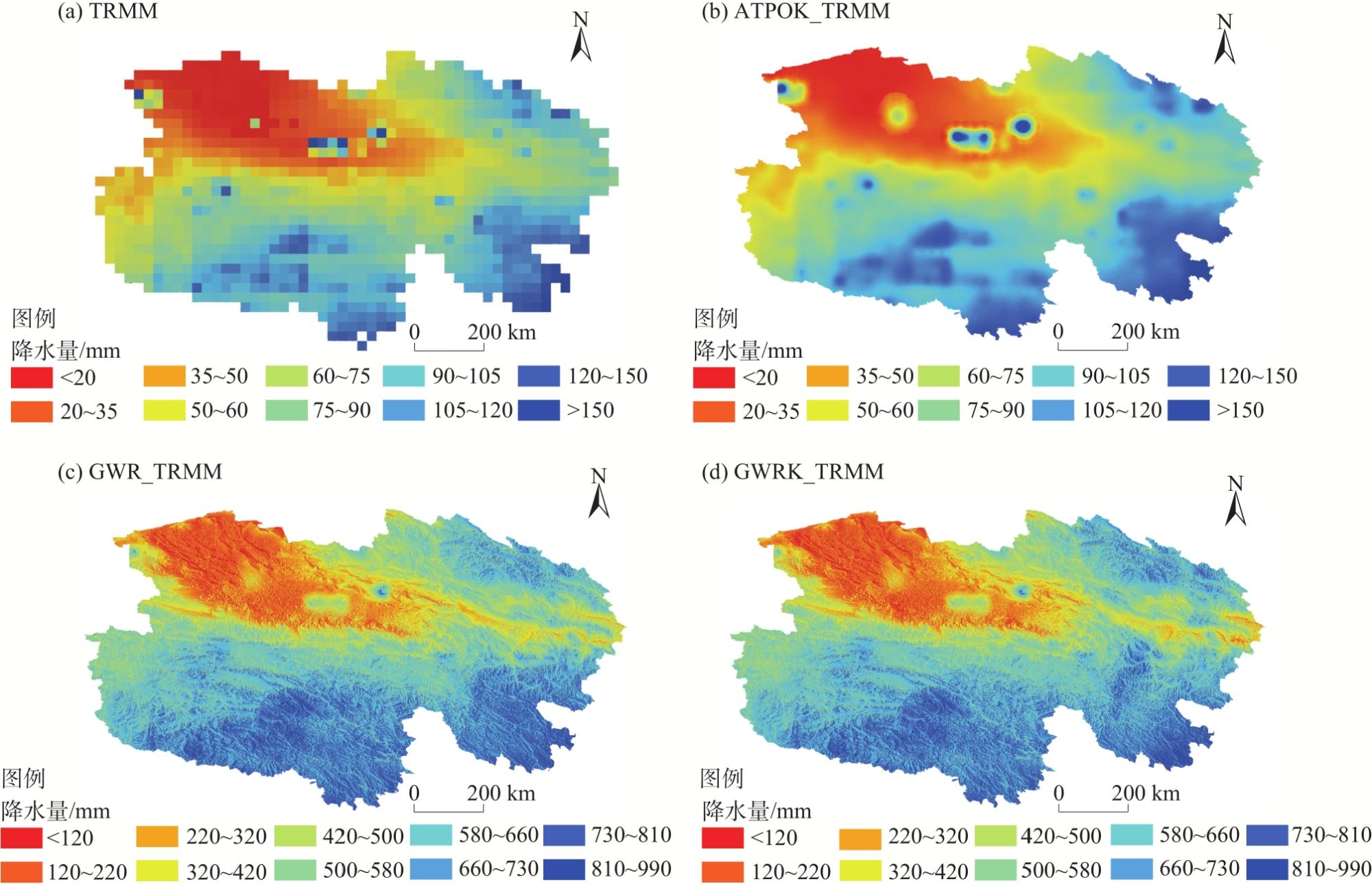
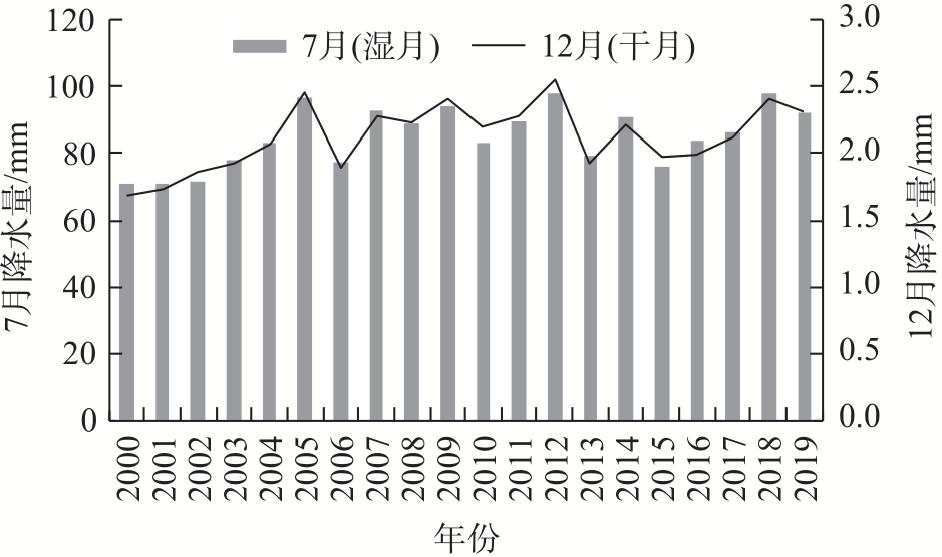
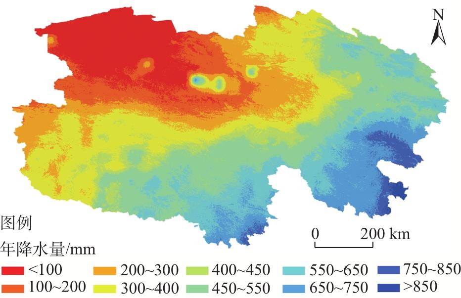
卫星遥感降水产品已广泛应用于估算降水,尤其是在地面观测站点稀少的地区。然而,这些卫星降水产品较低的空间分辨率,限制了其在局部地区的应用。因此,提出一种基于块到点克里金插值算法(ATPOK)与地理权重回归克里金残差校准算法(GWRK)组合的融合降尺度框架,对2000—2019年青海地区TRMM 3B43进行空间降尺度,并结合地面观测站点数据、归一化植被指数(NDVI)、数字高程模型(DEM)、坡度及坡向等辅助因子进行校准,最终得到1 km分辨率的降水产品。结果表明:(1) 本研究所提出的融合降尺度框架能有效提高TRMM 3B43降水数据的降尺度精度,但并不能消除TRMM 3B43降水高估的情况。(2) 与ATPOK算法相比,采用降尺度的TRMM降水数据和辅助因子的GWRK模型能更好地估算年、月降水量。(3) 基于对TRMM 3B43和NDVI相关关系研究,发现NDVI对降水的响应存在0~2个月的延迟。(4) 基于对降尺度降水产品时空变化分析,发现青海地区降水在月尺度上存在显著增长,其中干月年际变化率3.33%,湿月年际变化率1.79%。
王朋 , 石玉立 . 青海地区TRMM 3B43降水产品融合降尺度与时空特征分析[J]. 干旱区地理, 2024 , 47(7) : 1136 -1146 . DOI: 10.12118/j.issn.1000-6060.2023.559
Satellite remote sensing precipitation products have been widely used to estimate precipitation, especially in regions with sparse ground observation stations. However, the lower spatial resolution of these satellite products limits their application in localized regions and watersheds. This study proposes a fused downscaling framework based on the area-to-point kriging (ATPOK) algorithm and geographic weighted regression kriging (GWRK) algorithm to downscale TRMM 3B43 data for the Qinghai region of China from 2000 to 2019. The framework incorporates ground observation station data, normalized difference vegetation index (NDVI), digital elevation model, slope, and auxiliary factors for calibration, ultimately obtaining precipitation products at 1 km resolution. The results showed that: (1) The proposed fused downscaling framework can effectively improve the accuracy of TRMM 3B43 products; however, it cannot eliminate the overestimation of TRMM 3B43. (2) Compared to the ATPOK algorithm, the GWRK algorithm using data TRMM precipitation data and auxiliary factors can better estimate annual/monthly precipitation data. (3) Based on the study of the relationship between TRMM 3B43 and NDVI, it was found that NDVI responds to precipitation with a delay of 0-2 months. (4) Based on the spatiotemporal variation analysis of downscaled precipitation products, significant increases in monthly precipitation were observed in the Qinghai region, with an interannual change rate of 3.33% in dry month (December) and 1.79% in wet month (July).
Key words: spatial downscaling; TRMM 3B43; ATPOK; GWRK; downscaling-integration framework
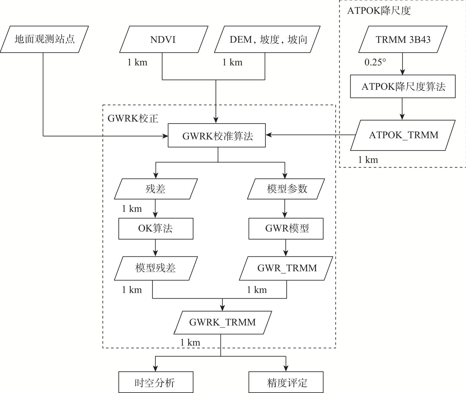
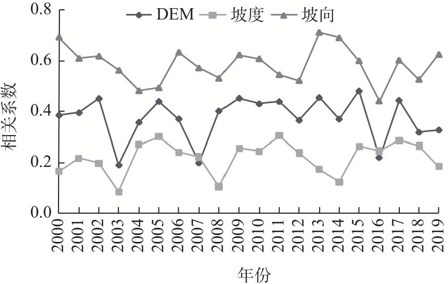
图2 技术路线注:NDVI为归一化植被指数;DEM为数字高程模型;ATPOK降尺度算法为块到点克里金插值算法;GWRK校正算法为地理权重回归克里金残差校准算法;OK算法为普通克里金算法;GWR模型为地理权重回归模型;TRMM 3B43为原始TRMM 3B43降水数据;ATPOK_TRMM为经过ATPOK算法降尺度后的1 km空间分辨率降水数据;GWR_TRMM为ATPOK_TRMM降水数据经GWR回归后的1 km空间分辨率降水数据;GWRK_TRMM为GWR模型残差经OK算法校准后的1 km空间分辨率降水数据。下同。 Fig. 2 Technical route |
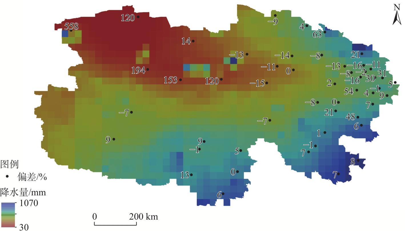
表1 校准前后原始TRMM 3B43在年尺度和月尺度上的精度评价结果Tab. 1 Evaluation results of precipitation data from original and downscaled TRMM 3B43 at annual and monthly scales |
| 时间尺度 | 降水数据 | 精度评价指标 | |||
|---|---|---|---|---|---|
| R2 | Bias/% | RMSE/mm | MAE/mm | ||
| 年尺度 | TRMM 3B43 | 0.86 | 4.93 | 73.16 | 59.50 |
| ATPOK_TRMM | 0.89 | 4.78 | 64.64 | 51.85 | |
| GWR_TRMM | 0.91 | 3.13 | 57.34 | 46.26 | |
| GWRK_TRMM | 0.92 | 3.60 | 55.70 | 45.39 | |
| 月尺度 | TRMM 3B43 | 0.87 | 4.76 | 6.15 | 4.96 |
| ATPOK_TRMM | 0.89 | 4.77 | 5.44 | 4.32 | |
| GWR_TRMM | 0.90 | 3.79 | 4.83 | 3.85 | |
| GWRK_TRMM | 0.91 | 4.32 | 4.68 | 3.78 | |
注:R2为决定系数;Bias为偏差;RMSE为均方根误差;MAE为平均绝对误差;TRMM 3B43为原始TRMM降水数据;ATPOK_TRMM为经过ATPOK降尺度后的降水数据;GWR_TRMM为对ATPOK_ TRMM降水数据经GWR回归后的降水数据;GWRK_TRMM为对GWR_TRMM降水数据经OK降尺度后的降水数据。 |
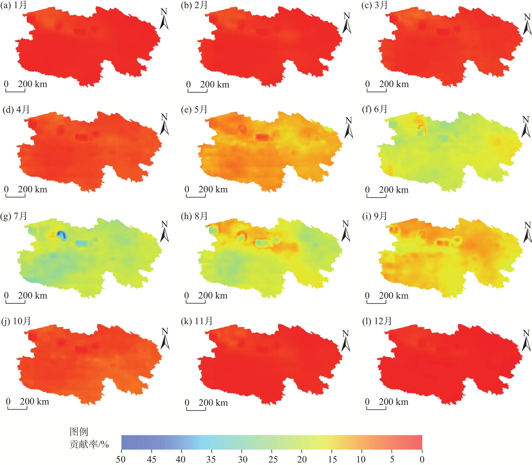
表2 青海地区逐月NDVI与同期、前1月、前2月TRMM 3B43降水的最大相关系数Tab. 2 Max correlation coefficients between monthly NDVI and concurrent, previous 1 month, and previous 2 months TRMM 3B43 in the Qinghai region |
| 月份 | |||
|---|---|---|---|
| 1 | 0.464 | 0.459 | 0.605 |
| 2 | 0.557 | 0.474 | 0.461 |
| 3 | 0.727 | 0.640 | 0.543 |
| 4 | 0.802 | 0.745 | 0.643 |
| 5 | 0.818 | 0.825 | 0.776 |
| 6 | 0.773 | 0.827 | 0.831 |
| 7 | 0.778 | 0.774 | 0.822 |
| 8 | 0.795 | 0.776 | 0.770 |
| 9 | 0.802 | 0.754 | 0.726 |
| 10 | 0.659 | 0.686 | 0.672 |
| 11 | 0.610 | 0.702 | 0.737 |
| 12 | 0.425 | 0.584 | 0.662 |
注: 、 和 分别表示NDVI与当月、前1个月和前2个月的TRMM3B43降水最大相关系数。 |
| [1] |
|
| [2] |
|
| [3] |
|
| [4] |
|
| [5] |
|
| [6] |
|
| [7] |
|
| [8] |
|
| [9] |
|
| [10] |
|
| [11] |
|
| [12] |
|
| [13] |
|
| [14] |
|
| [15] |
|
| [16] |
|
| [17] |
|
| [18] |
|
| [19] |
|
| [20] |
|
| [21] |
|
| [22] |
|
| [23] |
|
| [24] |
|
| [25] |
|
| [26] |
|
| [27] |
|
| [28] |
|
| [29] |
|
| [30] |
|
| [31] |
|
| [32] |
|
| [33] |
|
| [34] |
|
| [35] |
李运龙, 熊立华, 闫磊. 基于地理权重回归克里金的降水数据融合及其在水文预报中的应用[J]. 长江流域资源与环境, 2017, 26(9): 1360-1369.
[
|
| [36] |
|
| [37] |
韩雅, 朱文博, 李双成. 基于GWR模型的中国NDVI与气候因子的相关分析[J]. 北京大学学报(自然科学版), 2016, 52(6): 1125-1133.
[
|
| [38] |
|
| [39] |
|
/
| 〈 |
|
〉 |