
|
闫兆进(1991-),男,博士,预聘副教授,主要从事地学大数据挖掘与空间分析建模等方面的研究. E-mail: yanzhaojin@cumt.edu.cn |
收稿日期: 2023-12-20
修回日期: 2024-01-02
网络出版日期: 2026-03-11
基金资助
新疆维吾尔自治区重点研发计划项目课题(2022B01012-1)
科技部第三次新疆综合科学考察项目课题(2022xjkk1006)
国家自然科学基金项目(42201451)
中国博士后科学基金面上项目(2022M723379)
中央高校基本科研业务费专项(2024ZDPYCH1003)
浙江省社科联项目(2024N085)
Evaluation of land cover data product accuracy in urban agglomeration on the northern slope of Tianshan Mountains in Xinjiang
Received date: 2023-12-20
Revised date: 2024-01-02
Online published: 2026-03-11
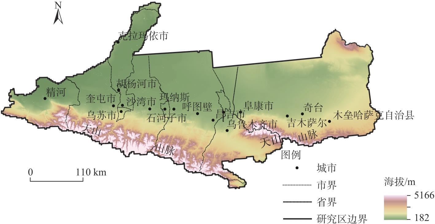
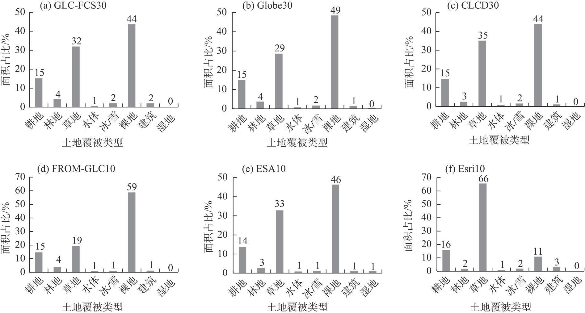
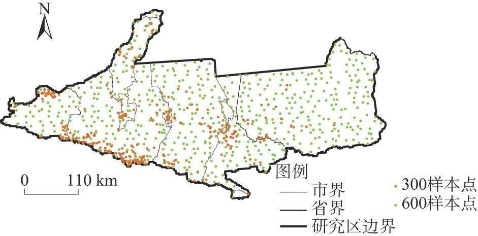
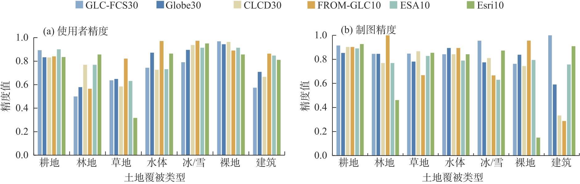
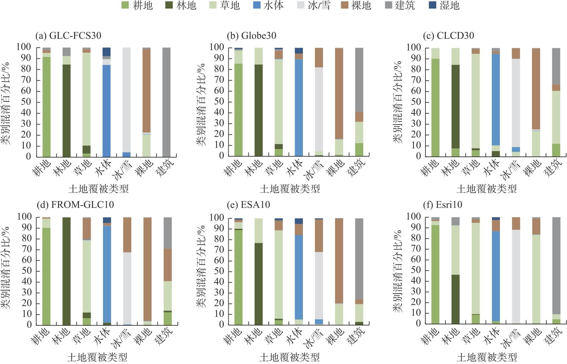
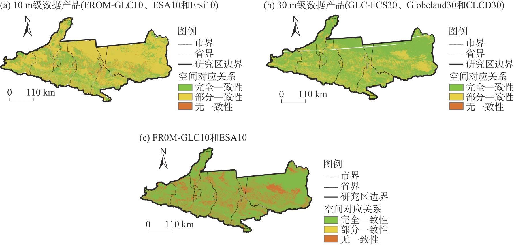
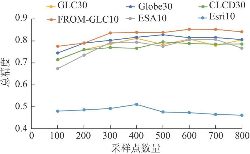
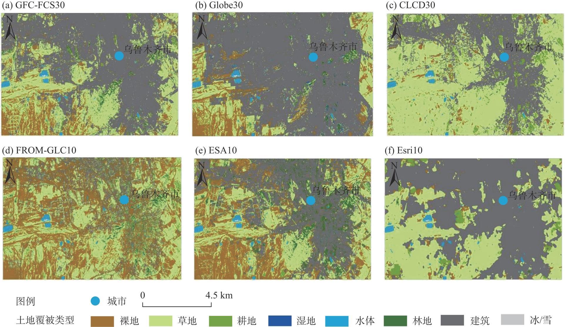
土地覆被产品为全球各种地球系统科学应用提供了重要的地表覆被信息,如CLCD30(30 m)、GlobeLand30(30 m,简称 Globe30)、GLC_FCS30(30 m)、FROM-GLC10(10 m)、Esri_Land_Cover_2020(10 m,简称 Esri10),以及ESAWorldCover2020(10 m,简称 ESA10),然而其在局地的精度和适用性如何尚不明确。基于Sentinel-2影像,通过样本精度评价和类别混淆评价对上述6套土地覆被数据产品在天山北坡城市群的精度及误差情况进行了研究和分析,并探讨了误差成因和不同数据产品的适用性。结果表明:(1)6套数据产品中,除Esri10外,其余5套数据产品的类型构成、面积占比相对一致。(2)GLC-FCS30、Globe30、CLCD30、FROM-GLC10、ESA10、Esri10的总体精度分别为0.8080、0.8147、0.7880、0.8531、0.8047、0.4725。(3)从产品适用性来看,GLC_FCS30适用于对耕地、裸地的分析,CLCD30适用于对林地、裸地的分析,FROM-GLC10适用于对草地、水体、冰/雪以及建筑的分析,ESA10适用于对耕地和草地的分析,Esri10适用于对林地、冰/雪以及建筑的分析,Globe30在各类别精度评价结果上更均衡。(4)类别混淆主要是耕地、林地以及草地之间及与其他类别的相互混淆,尤其是在土地覆被复杂的地区,如城市边缘区域。
闫兆进 , 孙雨晴 , HE Rong , 王冉 , 阮晓光 , 杨慧 , 慈慧 . 新疆天山北坡城市群土地覆被数据产品精度评价[J]. 干旱区地理, 2024 , 47(11) : 1852 -1862 . DOI: 10.12118/j.issn.1000-6060.2023.721
Land cover data products, including CLCD30 (30 m resolution), GlobeLand30 (30 m, referred to as Globe30), GLC_FCS30 (30 m), FROM-GLC10 (10 m), Esri_Land_Cover_2020 (10 m, referred to as Esri10), and ESAWorldCover2020 (10 m, referred to as ESA10), provide essential surface cover information for various earth system science applications globally. However, their accuracy and suitability for specific local areas remain uncertain. This study evaluates the accuracy and errors of these six land cover products in the northern slope of the Tianshan Mountains in Xinjiang, China, based on Sentinel-2 imagery, using sample accuracy assessment and category confusion evaluation. Furthermore, the causes of errors and the applicability of different products were analyzed. The results indicate that: (1) Among the six data product sets, except for Esri10, the composition and area percentages of land cover types are relatively consistent across the other five products. (2) The overall accuracies of these products are: GLC_FCS30 (0.8080), Globe30 (0.8147), CLCD30 (0.7880), FROM-GLC10 (0.8531), ESA10 (0.8047), and Esri10 (0.4725). (3) Regarding product applicability, GLC_FCS30 is effective for analyzing cropland and bareland; CLCD30 is optimal for forest and bareland; FROM-GLC10 excels in representing grassland, water bodies, snow/ice, and built-up areas; ESA10 is suitable for cropland and grassland; Esri10 performs well in forest, snow/ice, and built-up areas; and Globe30 maintains overall stability in accuracy across all categories. (4) Major category confusion occurs between cropland, forest, grassland, and other categories, especially in areas with complex land cover, such as urban fringes.
表1 土地覆被数据产品参数Tab. 1 Parameters of land cover data products |
| 产品名称 | 来源 | 分辨率/m | 区域 | 制图单位 | 生产年份 | 分类方法 | 参考数据 | 分类体系 (类别数量) |
|---|---|---|---|---|---|---|---|---|
| FROM-GLC10 | http://data.ess.tsinghua.edu.cn/fromglc2017v1.html | 10 | 全球 | 清华大学 | 2017 | 随机森林 | Sentinel-2 | LCCS(10) |
| ESA10 | https://viewer.esa-worldcover.org/worldcover | 10 | 全球 | 欧空局及全球多家科研机构 | 2020 | 随机森林 | Sentinel-1 Sentinel-2 | LCCS(8) |
| Esri10 | https://esri.maps.arcgis.com/ | 10 | 全球 | Esri,撞击观测站 | 2020 | 深度学习 | Sentinel-2 | LCCS(11) |
| GLC_FCS30 | http://doi.org/10.5281/zenodo.4280923 | 30 | 全球 | 中国科学院空天信息创新研究院 | 2020 | 监督分类 | Landsat、Sentinel-1 | LCCS(29) |
| Globe30 | https://GlobeLand30/ | 30 | 全球 | 国家基础地理信息中心等 | 2020 | 监督分类 | Landsat | LCCS(10) |
| CLCD30 | https://zenodo.org./ | 30 | 中国 | 武汉大学 | 2020 | 随机森林 | Landsat | LCCS(9) |
注:ESA10、Globe30、Esri10分别为ESAWorldCover2020、GlobeLand30、Esri_Land_2020的简称。下同。 |
表2 6套土地覆被数据产品的分类系统和统一分类系统Tab. 2 Classification system and harmonized classification system for the six land cover data products |
| 产品 | FROM-GLC10 | GLC_FCS30 | CLCD30 | ESA10 | Globe30 | Esri10 | 统一类别 |
|---|---|---|---|---|---|---|---|
| 类型 | 耕地 | 旱作农田、灌溉农田 | 耕地 | 耕地 | 农地 | 耕地 | 耕地 |
| 草地 | 草地、稀疏草丛、稀疏植被、草本覆盖 | 草地 | 草地 | 草地、苔原 | 牧场 | 草地 | |
| 灌木 | 灌木地、常绿灌木地 | 灌木 | 灌木 | 灌丛 | 牧场 | 草地 | |
| 林地 | 开阔常绿阔叶林、封闭落叶阔叶林、开阔常绿针叶林、封闭常绿针叶林、开阔落叶针叶林、封闭落叶针叶林、 | 林地 | 林地 | 森林 | 树木 | 林地 | |
| 湿地 | 地衣苔藓、湿地 | 湿地 | 湿地、苔藓 | 湿地 | 淹没植被 | 湿地 | |
| 水体 | 水体 | 水域 | 永久水体 | 水体 | 水体 | 水体 | |
| 不透水面 | 不透水表面 | 建设用地 | 建筑 | 不透水层 | 建筑 | 建筑 | |
| 裸地 | 裸地、固定裸地、不固定裸地 | 裸地 | 荒漠 | 裸地 | 裸地 | 裸地 | |
| 雪/冰 | 永久冻土/雪原 | 冰川 | 雪和冰 | 冰雪 | 冰/雪 | 冰/雪 | |
| - | - | - | - | - | 云 | - |
表3 6组数据产品的总精度和Kappa系数Tab. 3 Total accuracy and Kappa coefficient of the six land cover data products |
| 精度指标 | GLC-FCS30 | Globe30 | CLCD30 | FROM-GLC10 | ESA10 | Esri10 |
|---|---|---|---|---|---|---|
| 总精度 | 0.8080 | 0.8147 | 0.7880 | 0.8531 | 0.8047 | 0.4725 |
| Kappa系数 | 0.7128 | 0.7142 | 0.6802 | 0.7624 | 0.6986 | 0.3038 |
| [1] |
|
| [2] |
|
| [3] |
|
| [4] |
郭紫燕, 杨康, 刘畅, 等. 巴基斯坦土地覆盖数据产品季节性精度评价[J]. 遥感技术与应用, 2020, 35(3): 567-575.
[
|
| [5] |
|
| [6] |
|
| [7] |
|
| [8] |
|
| [9] |
|
| [10] |
|
| [11] |
|
| [12] |
|
| [13] |
|
| [14] |
|
| [15] |
康军梅. 多源遥感土地覆被产品一致性评价及要素提取分析应用研究[D]. 西安: 长安大学, 2020.
[
|
| [16] |
付东光, 李登秋, 陆灯盛, 等. 基于调查数据的福建省3种30 m全球土地覆盖产品精度评价[J]. 福建师范大学学报(自然科学版), 2023, 39(2): 122-136.
[
|
| [17] |
闫明, 庞勇, 何云玲, 等. 普洱多源土地覆盖产品一致性分析与精度评价[J]. 林业资源管理, 2023(1): 173-182.
[
|
| [18] |
|
| [19] |
侯婉, 侯西勇. 全球海岸带多源土地利用覆盖遥感分类产品一致性分析[J]. 地球信息科学学报, 2019, 21(7): 1061-1073.
[
|
| [20] |
吴宗洋, 蔡卓雅, 郭英, 等. 黄河流域多源遥感土地覆被数据精度评价与一致性分析[J]. 中国生态农业学报, 2023, 31(6): 917-927.
[
|
| [21] |
夏文韬, 王莺, 冯琦胜, 等. 甘南地区MODIS土地覆盖产品精度评价[J]. 草业科学, 2010, 27(9): 11-18.
[
|
| [22] |
|
| [23] |
李美娇, 何凡能, 赵彩杉, 等. 全球历史LUCC数据集新疆地区耕地数据可靠性评估[J]. 生态环境学报, 2022, 31(6): 1215-1224.
[
|
| [24] |
陈逸聪, 邵华, 李杨. 多源土地覆被产品在长三角地区的一致性分析与精度评价[J]. 农业工程学报, 2021, 37(6): 142-150.
[
|
| [25] |
|
| [26] |
黄亚博, 廖顺宝. 首套全球30 m分辨率土地覆被产品区域尺度精度评价——以河南省为例[J]. 地理研究, 2016, 35(8): 1433-1446.
[
|
| [27] |
宋宏利, 张晓楠. 国家尺度异源土地覆被遥感产品精度评价[J]. 国土资源遥感, 2018, 30(3): 26-32.
[
|
| [28] |
黄亚博. 基于多源数据融合的MODIS土地覆被产品精度评价与改进方法研究[D]. 开封: 河南大学, 2017.
[
|
| [29] |
宋宏利, 张晓楠. 基于VGI的土地覆被遥感产品精度验证[J]. 河北工程大学学报(自然科学版), 2016, 33(4): 98-102.
[
|
| [30] |
杨梅花, 程锦涛, 郭佳星, 等. 新疆城市规模分布与自然地理相关性分析[J]. 干旱区地理, 2022, 45(6): 1958-1967.
[
|
| [31] |
|
| [32] |
孙桂丽, 陆海燕, 郑佳翔, 等. 新疆生态脆弱性时空演变及驱动力分析[J]. 干旱区研究, 2022, 39(1): 258-269.
[
|
/
| 〈 |
|
〉 |