
|
邝吉鸿,男,1985年生,高级工程师,从事地质资源与地质工程研究。E-mail:250293547@qq.com |
收稿日期: 2025-02-20
修回日期: 2025-04-10
网络出版日期: 2025-11-06
基金资助
广西壮族自治区国土资源厅(桂国土资办[2013]262号)
广西壮族自治区国土资源厅(桂国土资办[2010]1226号)
Practice and discussion of the induced polarization secondary time difference method in water exploration of carbonaceous argillaceous limestone areas based on integrated geophysical exploration
|
KUANG Jihong,male,born in 1985,senior engineer,focusing on geological resources and geological engineering. E-mail:250293547@qq.com |
Received date: 2025-02-20
Revised date: 2025-04-10
Online published: 2025-11-06
Supported by
Guangxi Zhuang Autonomous Region Department of Land and Resources(桂国土资办[2013]262号)
Guangxi Zhuang Autonomous Region Department of Land and Resources(桂国土资办[2010]1226号)
邝吉鸿 , 马富安 , 张国玮 , 李云超 . 基于综合物探的激电二次时差法在含碳质泥质灰岩区找水探测实践与探讨[J]. 世界核地质科学, 2025 , 42(3) : 596 -606 . DOI: 10.3969/j.issn.1672-0636.2025.03.010
To address the applicability challenges of geophysical water exploration methods in the Carboniferous Huangjin formation of carbonaceous-argillaceous limestone characterized by uneven development of dissolution fissure,complex hydraulic connectivity of argillaceous shale interlayers,concealed groundwater occurrence conditions,scant water resources,and improve the success rate of water well drilling, This paper adopts high-density resistivity and Audio-frequency Magnetotelluric Sounding (AMT) methods to detect low-resistivity anomalies in an area of Shaoshui town,Guilin. By applying the induced polarization (IP) secondary time difference method to analyze and delineate water-induced anomalies within these low-resistivity zones. the spatial distribution and occurrence characteristics of groundwater were identified. Results indicate that the AB/2 positions characterized by low-resistivity anomalies,positive induced polarization secondary time difference values with good continuity correspond to the actual aquifer locations. Meanwhile,areas with single-point values or values below 50 ms and poor continuity exhibit low water-bearing capacity.
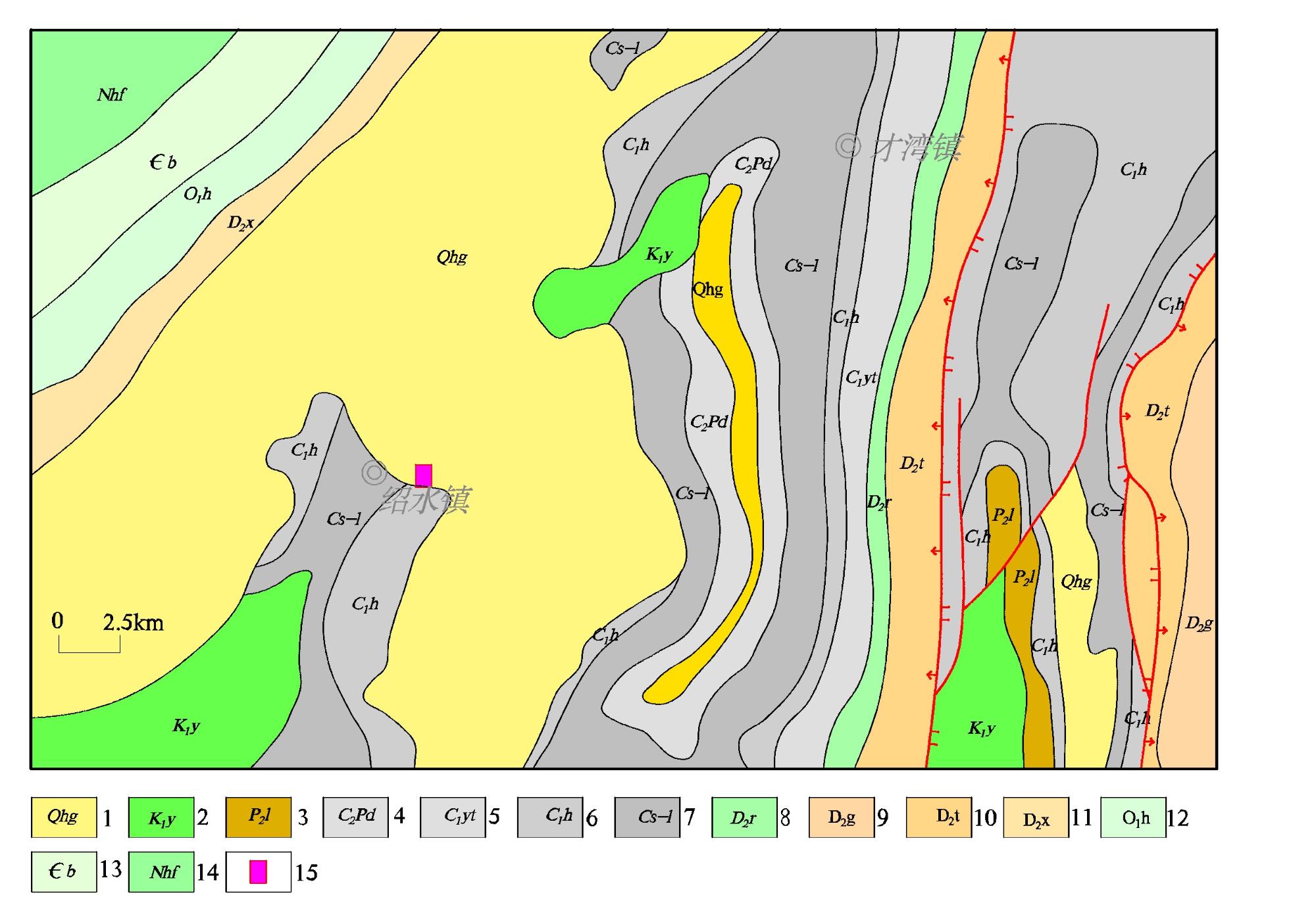
图1 研究区区域水文地质图(据桂林幅1:200 000水文地质图)1—第四系桂平组;2—第四系望高组;3—白垩纪;4—二叠系梁山组;4—石炭系中上段;6—石炭系黄金组;7—松散岩类孔隙水,水量中等;8—松散岩类孔隙水,水量贫乏;9—基岩裂隙水,水量贫乏;10—裸露型碳酸盐岩裂隙溶洞水,水量贫乏;11—裸露型碳酸盐岩、碎屑岩互层溶洞裂隙水,水量贫乏;12—浅覆盖型上层孔隙水、下层岩溶水,水量中等;13—浅覆盖型上层孔隙水、下层岩溶水,水量贫乏;14—研究区位置。 Fig. 1 Hydrogeological map of the study area (Quoted from the 1:200 000 hydrogeological map of Guilin) 1-Quaternary Guiping formation;2-Quaternary Wanggao formation;3-Cretaceous;4-Permian Liangshan formation;5-Middle to Upper Carboniferous; 6-Carboniferous Huangjin formation;7-Porosity water in loose rocks,moderate water volume;8-Porosity water in loose rocks,poor water volume;9-Bedrock fissure water,poor water volume;10-Exposed carbonate rock fissure-karst water,poor water volume;11-Exposed carbonate rock and clastic rock interlayer karst fissure water,poor water volume;12-Shallow overburden type with upper porosity water and lower karst water,moderate water volume;13-Shallow overburden type with upper porosity water and lower karst water,poor water volume;14-Location of the study area. |
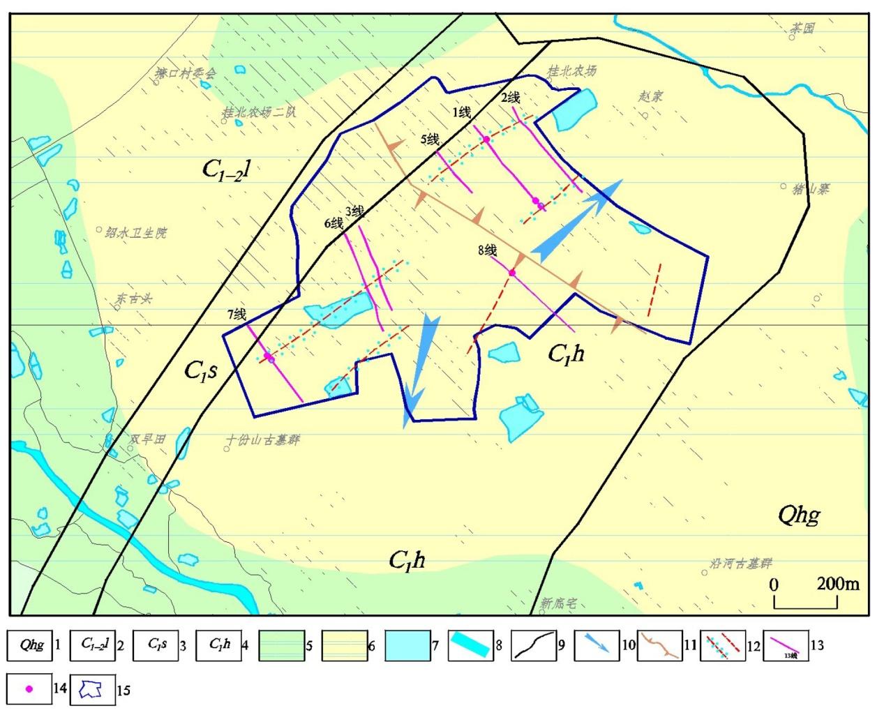
图2 研究区水文地质及物探工作布置图1—第四系桂平组;2—第四系望高组;3—石炭系寺门组;4—石炭系黄金组;5—地质界线;6—松散岩类孔隙水水量中等;7—松散岩类孔隙水水量贫乏;8—裸露型碳酸盐岩、碎屑岩互层溶洞裂隙水水量贫乏;9—季节性地表积水区(塘);10—浅覆盖型上层孔隙水、下层岩溶水,水量中等;11—浅覆盖型上层孔隙水、下层岩溶水,水量贫乏;12—河流及流向;13—地下水流向;14—分水岭;15—推测的含水和不含水破碎带;16—物探测线及编号;17—激电测深点;18—物探工作范围。 Fig. 2 Layout map of hydrogeological and geophysical prospecting work in the study area 1-Quaternary guiping formation;2-Quaternary wanggao formation;3-Carboniferous simen formation;4-Carboniferous huangjin formation;5-Geological boundary;6-Porosity water in loose rocks with moderate water volume;7-Porosity water in loose rocks with poor water volume;8-Exposed carbonate rock and clastic rock interbedded karst fissure water with poor water volume;9-Seasonal surface water accumulation area (Pond);10-Shallow overburden type with upper porosity water and lower karst water,moderate water volume;11-Shallow overburden type with upper porosity water and lower karst water,poor water volume;12-Rivers and flow directions;13-Groundwater flow directions;14-Watershed;15-Inferred aquifer and non-aquifer fractured zones;16-Geophysical prospecting lines and numbers;17-Induced polarization sounding points;18-Scope of geophysical prospecting work. |
表1 研究区电性参数表Table 1 Electrical parameters of the study area |
| 岩石名称称 | 电阻率/Ω·m | 极化率/% |
|---|---|---|
| 地下水 | <100 | 2.2~4.5 |
| 完整灰岩 | 1 000~100 000 | 0.5~1.8 |
| 第四系覆盖层 | 10~500 | 0.3~1.2 |
| 含碳灰岩 | 50~300 | 3.8~8.6 |
| 砂岩 | 100~450 | 0.5~1.3 |
| 含水岩溶构造 | <500 | 3.2~5.1 |
| 泥灰岩 | 10~100 | 0.5~2.1 |
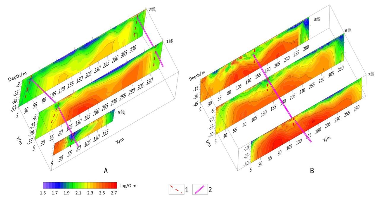
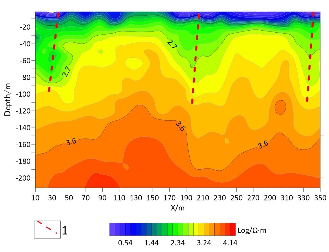
图3 研究区高密度电阻率法反演成果及推测构造图a—2、1和5线;b—3、6和7线。 1—推测破碎带;2—推测导水通道。 Fig. 3 Inversion results of high density resistivity and inferred structures in the study area a-Line 2,1,and 5;b-Line 3,6,and 7. 1-Inferred fracture zone;2-Inferred water conduit. |
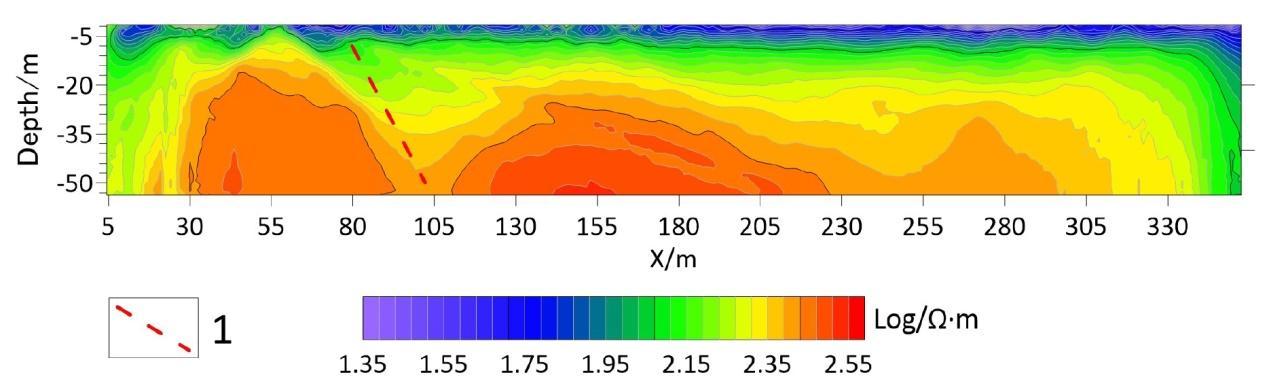
图4 研究区2线音频大地电磁测深电阻率成果图1—推测破碎带。 Fig. 4 Resistivity result profile of AMT line 2 in the study area 1-Inferred fracture zone. |
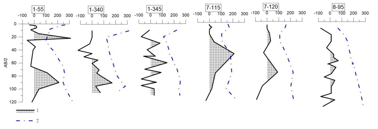
图6 研究区激电二次时差值曲线图a—1线55 m测点;b—1线340 m测点;c—1线345 m测点;d—7线115 m测点;e—7线120 m测点;f—8线95 m测点。 1—激电二次时差值(单位:ms)曲线及正异常;2—视电阻率曲线(单位:Ω·m);3—激电供电极距AB的 (单位:m)。 Fig. 6 Profiles of the IP secondary time difference values in the study area a-Measurement point at 55 m on line 1;b-Measurement point at 340 m on line 1;c-Measurement point at 345 m on line 1;d-Measurement point at 115 m on line 7;e-Measurement point at 120 m on line 7;f-Measurement point at 95 m on line 8. 1-Curve of secondary time difference and positive anomaly;2-Apparent resistivity curve;3-AB/2 of the IP power supply pole distance. |
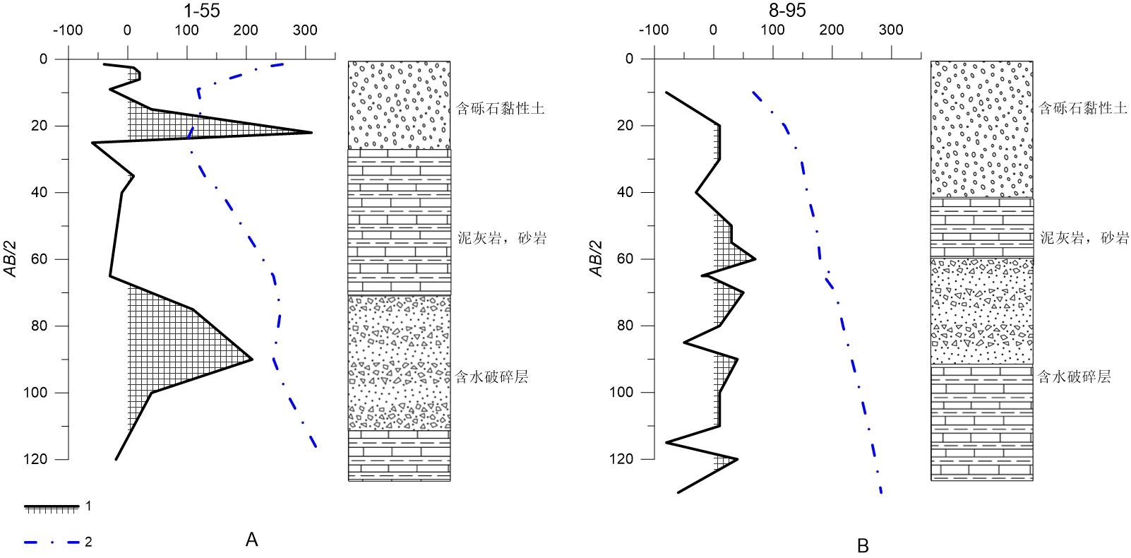
图7 研究区激电二次时差值解释分析图a—1线55 m测点;b—8线95 m测点。 1—激电二次时差值(单位:ms)曲线及正异常;2—视电阻率曲线(单位:Ω·m);3—激电供电极距AB的 (单位:m)。 Fig. 7 Profiles and the lithological interpretation of IP secondary time difference values in the study area a-Measurement point at 55 m on line 1;b-Measurement point at 95 m on line 8. 1-Curve of secondary time difference and positive anomaly;2-Apparent resistivity curve;3-AB/2 of the IP power supply pole distance. |
| 1 |
屈利军, 李波, 周佩. 综合物探方法在湘中贫水山区找水中的应用[J]. 物探与化探, 2017, 41(5): 835-839.
|
| 2 |
张志. 综合物探方法在泾县榔桥地区矿泉水勘查的应用研究[D]. 合肥: 合肥工业大学, 2022
|
| 3 |
杨传伟, 刘启蒙, 王琳琳, 等. 水文地质调查与物探在岩浆岩地区找水中的应用——以田黄镇律庄村地下水勘查为例[J]. 地下水, 2024, 46(1):133-135.
|
| 4 |
刘声凯, 刘海飞, 黄超, 等. 水文地质调查与综合物探在赣南花岗岩地区找水中的应用[J]. 地质与勘探, 2021, 57(3):584-592.
|
| 5 |
郑智杰, 曾洁, 甘伏平, 等. 综合物探方法在碎屑岩地区找水中的应用——以云南宣威大路边村为例[J]. 中国岩溶, 2024, 43(2):432-440.
|
| 6 |
朱文科. 综合物探方法在凤阳石灰岩地区水资源勘查中的应用[J]. 安徽地质, 2022, 32(1):53-55.
|
| 7 |
康方平, 蒋建良, 彭杰, 等. 综合物探方法在湖南某贫水板岩地区找水的应用研究[J]. 工程地球物理学报, 2020, 17(2):258-264.
|
| 8 |
张彪, 刘良志, 倪进鑫, 等. 综合物探方法在花岗岩严重缺水地区找水勘查中的应用[J]. 工程地球物理学报, 2015, 12(4):501-507.
|
| 9 |
黄国民, 李世平, 陶毅, 等. 广西碎屑岩地区电法找水实例[J]. 物探与化探, 2019, 43(1):77-83.
|
| 10 |
李菊红, 孙彦良, 娄佰信. 瞬变电磁法在新疆哈密花岗岩地区寻找地下水资源中的应用[J]. 世界核地质科学, 2024, 41(3): 540-549 (in Chinese).
|
| 11 |
赵俊, 向龙洲, 李忠, 等. 综合物探在水文地质调查中的应用及适用性分析[J]. 云南大学学报(自然科学版), 2017, 39(增刊2):110-115+123.
|
| 12 |
余京. 综合物探在岩溶断层中找水的研究及其应用[J]. 地下空间与工程学报, 2017, 13(增刊1): 442-445.
|
| 13 |
严小丽, 康慧敏, 王光杰, 等. AMT方法在鳌山卫花岗岩地区深部地热构造勘探中的应用[J]. 地球物理学进展, 2019, 34(5):1945-1953.
|
| 14 |
张苗红, 梁庭祥, 陈永东. 云龙县上坪子镍矿小火烧岩体含矿性及找矿方向[J]. 云南地质, 2015, 34(2):185-188.
|
| 15 |
信永水. “二次时差法”原理初探[J]. 煤田地质与勘探, 1987(4):50-54.
|
| 16 |
王程. 基于激电法半衰时探水的可行性研究[J]. 物探化探计算技术, 2023, 45(5):597-603.
|
| 17 |
符海转, 王世军, 黄泽佼, 等. 海南省陵水县高峰地热田水文地球化学特征与成因分析[J]. 世界核地质科学, 2024, 41(3):508-521.
|
| 18 |
谢明魁. 二次时差法探测地下水[J]. 物化探计算技术, 1987(4):331-337.
|
/
| 〈 |
|
〉 |