
|
薛庆,男,1985年生,高级工程师,主要从事环境遥感监测研究。E-mail:122717561@qq.com |
收稿日期: 2025-01-04
修回日期: 2025-01-14
网络出版日期: 2025-11-07
基金资助
河北省航空探测与遥感技术重点实验室自主研发项目(202417)
Study on the distribution characteristics of warm drainage from a nuclear power plant based on satellite remote sensing
|
XUE Qing,male,born in 1985,senior engineer,focusing on remote sensing monitoring of nuclear power thermal discharge and geological hazard investigation technology research. E-mail:122717561@qq.com |
Received date: 2025-01-04
Revised date: 2025-01-14
Online published: 2025-11-07
Supported by
self-developed projects at the Key Laboratory of Airborne Survey and Remote Sensing Technology of Hebei Province(202417)
薛庆 , 姜雪 , 章新益 , 张恩 , 杜继龙 . 基于卫星遥感的某核电站温排水分布特征研究[J]. 世界核地质科学, 2025 , 42(1) : 166 -177 . DOI: 10.3969/j.issn.1672-0636.2025.01.014
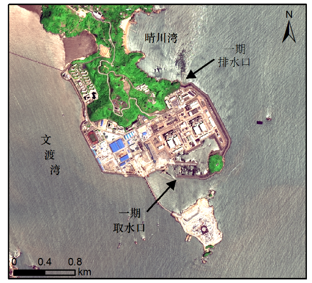
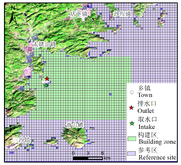
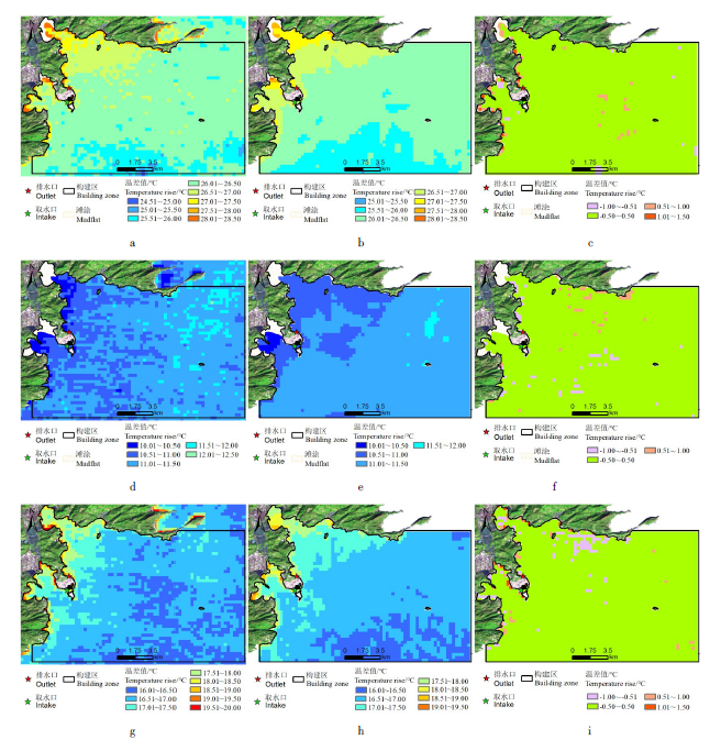
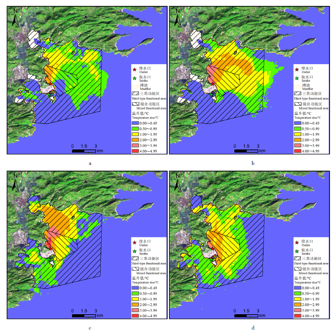
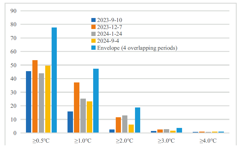
With the rapid development of China’s nuclear power industry,the impact of thermal discharge on the surrounding marine environment is increasingly attracting attention. Objective and accurate background temperatures are crucial for accurately assessing the thermal effects of warm water discharge. In this article, the sea area near a nuclear power plant in Fujian was studied. Based on long-term thermal infrared satellite data before the operation of the first unit,the distribution of sea surface temperature field under different seasons and tidal conditions was obtained through temperature inversion. By using grid method and correlation analysis method,the sub zones with the highest temperature correlation inside and outside the submersible discharge area were determined,and a continuous background temperature field with multi-point temperature coupling was constructed. The temperature rise field was extracted using recent thermal infrared satellite data,and the impact of the operation of four units on the temperature rise in the nearby sea area was evaluated. The results shows that using the multi-point temperature substitution method to extract the reference temperature is effective and reliable. Before the operation of nuclear power,the temperature field in the study area showed significant temperature differences and band like distribution characteristics:in winter,the temperature gradually decreased from offshore to nearshore,while in summer and other months with higher temperatures,the opposite trend was observed. After the operation of the nuclear power plant,there was a significant temperature rise area in the sea area near the discharge outlet. During the ebb tide period,the temperature discharge mainly affected Qingchuan Bay,while during the flood tide period,both Qingchuan Bay and Wendu Bay were affected. The area of temperature rise exceeding 2.0 ℃ is larger in winter than in summer under the same tidal state,and the area during high tide is larger than that during low tide in the same season.
表1 卫星传感器热红外波段特性对比Table 1 Comparison of thermal infrared band characteristics of satellite sensors |
| 数据类型 | 传感器 | 光谱范围/μm | 地面幅宽/km | 空间分辨率/m | 重访周期/d |
|---|---|---|---|---|---|
| HJ-1B | IRS | B8:10.5~12.5 | 720 | 300 | 4 |
| Landsat5 | TM | B6:10.4~12.5 | 185 | 120 | 16 |
| Landsat8 | TIRS1 | B10:10.6-11.2 B11:11.5-12.5 | 185 | 100 | 16 |
| Landsat9 | TIRS2 | B10:10.6-11.2 B11:11.5-12.5 | 185 | 100 | 16 |
表2 卫星数据统计表Table 2 Satellite data statistics table |
| 序号 | 日期 | 卫星类型 | 潮态 | 潮高/cm | 机组运行状况 |
|---|---|---|---|---|---|
| 1 | 2010年12月20日 | HJ-1B | 涨潮 | 203 | 未运行 |
| 2 | 2010年12月27日 | Landsat-5 | 涨潮 | -77 | 未运行 |
| 3 | 2010年12月28日 | HJ-1B | 涨潮 | -147 | 未运行 |
| 4 | 2011年7月23日 | Landsat-5 | 落潮 | -135 | 未运行 |
| 5 | 2011年7月24日 | HJ-1B | 落潮 | -150 | 未运行 |
| 6 | 2011年8月21日 | HJ-1B | 涨潮 | -30 | 未运行 |
| 7 | 2011年12月17日 | HJ-1B | 涨潮 | -147 | 未运行 |
| 8 | 2012年5月5日 | HJ-1B | 落潮 | 220 | 未运行 |
| 9 | 2012年9月29日 | HJ-1B | 落潮 | 174 | 未运行 |
| 10 | 2012年10月3日 | HJ-1B | 涨潮 | 246 | 未运行 |
| 11 | 2012年10月18日 | HJ-1B | 涨潮 | 227 | 未运行 |
| 12 | 2012年12月6日 | HJ-1B | 涨潮 | -92 | 未运行 |
| 13 | 2023年9月10日 | Landsat-8 | 落潮 | -83 | 4台机组运行 |
| 14 | 2023年12月7日 | Landsat-9 | 落潮 | -101 | 4台机组运行 |
| 15 | 2024年1月24日 | Landsat-9 | 涨潮 | 188 | 4台机组运行 |
| 16 | 2024年9月4日 | Landsat-9 | 涨潮 | 238 | 4台机组运行 |
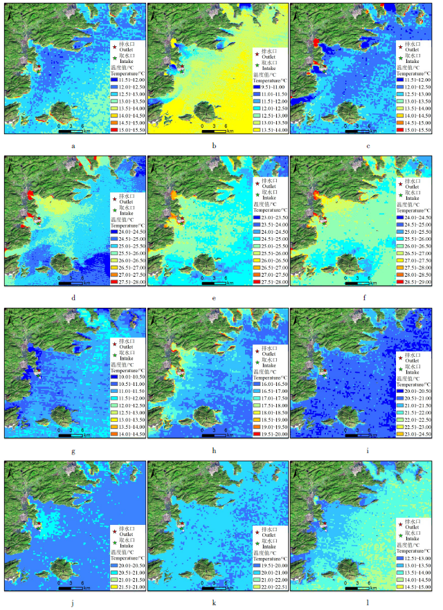
图3 核电站首台机组运行前热红外温度场图Fig. 3 Thermal infrared temperature field diagram of the first unit of the nuclear power plant before operation a—2010-12-20;b—2010-12-27;c—2010-12-28;d—2011-07-23;e—2011-07-24;f—2011-8-21;g—2011-12-17;h—2012-05-05;i—2012-09-29;j—2012-10-03;k—2012-10-18;l—2012-12-06。 |
| 1 |
张建永, 梁春利, 石海岗, 等. 热红外遥感技术在核电站温排水监测中的应用[J]. 铀矿地质, 2021, 37(3):534-540.
|
| 2 |
陈望. 温排水效应对秦山核电厂1号机组的影响及应对措施[J]. 中国核电, 2021, 14(1):114-119.
|
| 3 |
代丽, 姜新舒, 张文杰, 等. 滨海电厂取排水对鱼类资源的影响机制及应对策略[J]. 给水排水, 2023, 59 (增刊1):301-307.
|
| 4 |
叶文琪, 刘翰仁, 李尚鲁, 等. 秦山核电站邻近海域生态环境长期变化[J]. 海洋开发与管理, 2021, 38 (9):80-87.
|
| 5 |
王薇, 何桂萍, 关骁倢, 等. 我国滨海核电厂取排水方式现状及其对海洋生态环境的影响[J]. 浙江大学学报(理学版), 2024, 51(6):769-780.
|
| 6 |
国家海洋局第三海洋研究所,青岛海洋大学. 海水水质标准[S]. 北京: 国家环境保护局,1997.
Third Institute of Oceanography,Ministry of Natural Resources,Ocean University of Qingdao. Sea water quality standard[S]. Beijing: Ministry of Ecology and Environment of the People’s Republic of China,1997 (in Chinese).
|
| 7 |
段四波, 茹晨, 李召良, 等. Landsat卫星热红外数据地表温度遥感反演研究进展[J]. 遥感学报, 2021, 25(8):1591-1617.
|
| 8 |
许静, 朱利, 姜建, 等. 基于HJ-1B与TM热红外数据的大亚湾核电基地温排水遥感调查[J]. 中国环境科学, 2014,(34):1181-1186.
|
| 9 |
陈瀚阅, 朱利, 李家国, 等. 基于Landsat8数据的2种海表温度反演单窗算法对比——以红沿河核电基地海域为例[J]. 国土资源遥感, 2018, 30 (1):45-53.
|
| 10 |
张春雷, 高丽辉, 石海岗, 等. 田湾核电温排水遥感监测与数模一致性分析[J]. 环境监测管理与技术, 2018, 30(3):67-71.
|
| 11 |
张爱玲, 朱利, 陈晓秋, 等. 核电站温排水卫星遥感监测应用研究[J]. 环境监测管理与技术, 2014, 26 (6):12-16.
|
| 12 |
陈小莉, 段亚飞, 赵懿珺, 等. 基于数值模拟和原型观测联合的电厂温排水影响评价[J]. 水利学报, 2023, 54(1):94-104.
|
| 13 |
生态环境部卫星环境应用中心. 滨海核电厂温排水卫星遥感监测技术规范(试行)[S]. 北京: 生态环境部, 2021.
Satellite Application Center for Ecology and Technical specification to thermal discharge monitoring for coastal nuclear power plants based on satellite remote sensing (on trial)[S]. Beijing: Ministry of Ecology and Environment of the People's Republic of China, 2021 (in Chinese).
|
| 14 |
董双发, 范晓, 石海岗, 等. 基于Landsat8和无人机的福清核电温排水分布研究[J]. 自然资源遥感, 2022, 34 (03):112-120.
|
| 15 |
邢梦玲, 王迪峰, 何贤强, 等. 基于Landsat遥感数据的田湾核电站温排水时空特征研究[J]. 海洋学研究, 2020, 38 (4):72-79.
|
| 16 |
隋超, 朱君, 王庆, 等. 基于温度梯度算法的核电温排水遥感影像背景温度提取方法研究[J/OL]. 海洋科学进展, 2024,1-9[2024-12-29]. http://kns.cnki.net/kcms/detail/37.1387.P.20240401.1640.006.html
|
| 17 |
王雅萍, 马秀秀, 李家国, 等. 核电温排水基准温度星地协同提取与分析——以宁德为例[J]. 遥感学报, 2023, 27(8):1899-1913.
|
| 18 |
唐娅菲. 滨海核电运行安全典型致灾生物研究[D]. 上海海洋大学, 2018.
|
| 19 |
陈津乐, 张锦水, 段雅鸣, 等. 中分辨率遥感影像云检测与厚云去除研究综述[J]. 遥感技术与应用, 2023, 38 (1):143-155.
|
| 20 |
温亚飞, 刘宇, 王光辉, 等. Landsat 9数据的地表温度反演算法优化[J]. 测绘通报, 2023(7):74-79.
|
| 21 |
卢响军, 许尘璐, 郭金金. 基于Landsat 8数据的地表温度反演方法对比分析[J]. 干旱环境监测, 2023, 37(3):138-144.
|
| 22 |
石海岗, 薛庆, 章新益, 等. 基于遥感的海域环境变化监测分析[J]. 环境监测管理与技术, 2024, 36(1):53-56.
|
| 23 |
夏盈盈, 刘子铭, 崔宇升, 等. 基于Landsat遥感数据的射阳港电厂温排水时空特征[J]. 江苏海洋大学学报(自然科学版), 2022, 31 (3):42-48.
|
| 24 |
王水石, 杨云汉, 邱骏挺, 等. 银根地区Landsat 8星数据地下水信息反演及其对砂岩型铀矿勘查的指示[J] .世界核地质科学, 2024, 41(2):364-375.
|
| 25 |
余晓磊, 巫兆聪. 利用环境一号卫星热红外影像反演渤海海表温度[J]. 海洋技术, 2011, 30 (2):1-6.
|
/
| 〈 |
|
〉 |