
Ecological sensitivity evaluation of Longfeng Wetland Provincial Nature Reserve based on GIS
Received date: 2024-07-02
Revised date: 2025-03-04
Online published: 2026-03-12
Copyright
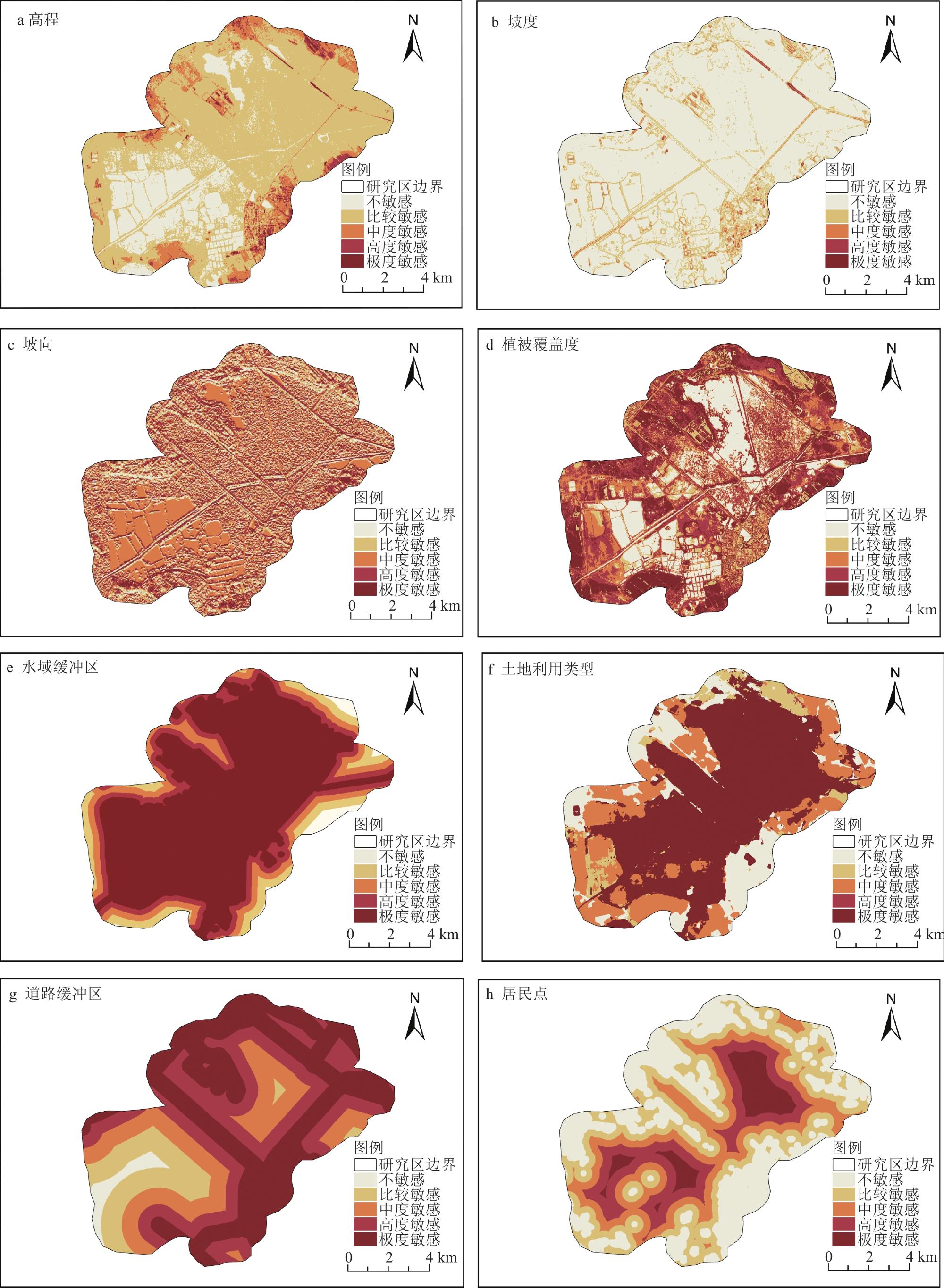
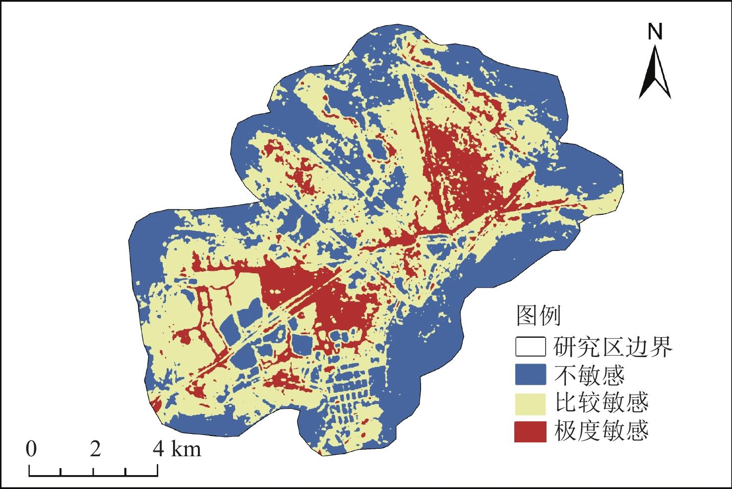
Ecological sensitivity assessment plays a crucial role in regional environmental protection and the formulation of functional zoning. Using GIS, an ecological sensitivity assessment was conducted on the Longfeng Wetland. Eight indicators elevation, slope, slope aspect, vegetation cover, water body buffer zone, land use type, road buffer zone, and settlement were selected to construct an ecological sensitivity evaluation system. The Analytic Hierarchy Process (AHP) and GIS spatial analysis were employed to assess the ecological sensitivity of the study area. The results indicate that the overall ecological sensitivity of the Longfeng Wetland is relatively low, with a predominance of moderately sensitive areas; vegetation cover and water body buffer zones have the greatest influence on ecological sensitivity; non-sensitive, moderately sensitive, and highly sensitive areas account for 39.5%, 46.4%, and 14.1% of the Longfeng Wetland's total area, respectively; highly sensitive areas are concentrated in the northeastern and central parts of the study area, primarily in reed marsh wetlands, with additional concentrations in the southwestern part's bog wetlands. Moderately sensitive areas are distributed around the periphery of highly sensitive areas, while the remaining areas are non-sensitive, primarily located along the edges of the study area. The basic spatial pattern of sensitivity is a gradual decrease from the central water body of the protected area outward. Based on the evaluation results, relevant recommendations for environmental protection and ecological construction are proposed to provide reference for the protection of wetland ecology and the planning of wetland landscapes.
Zhu Mianxuan , Zhang Ting , Hu Haihui . Ecological sensitivity evaluation of Longfeng Wetland Provincial Nature Reserve based on GIS[J]. Wetland Science, 2025 , 23(5) : 878 -887 . DOI: 10.13248/j.cnki.wetlandsci.20240181
1 Ecological sensitivity evaluation index system生态敏感性评价指标体系 |
| 目标层 | 准则层 | 指标层 |
| 生态敏感性评价 | 地理因素 | 高程 |
| 坡度 | ||
| 坡向 | ||
| 环境因素 | 植被覆盖度 | |
| 水域缓冲区 | ||
| 人为因素 | 土地利用类型 | |
| 道路缓冲区 | ||
| 居民点 |
2 Criteria layer weights准则层权重 |
| 环境因素 | 地理因素 | 人为因素 | 权重值(Wj) | 一致性比例(CR) | λmax | |
| 环境因素 | 1.000 0 | 1.900 0 | 1.6 | 0.465 2 | 0.000 5 | 3.000 5 |
| 地理因素 | 0.526 3 | 1.000 0 | 0.9 | 0.250 4 | ||
| 人为因素 | 0.625 0 | 1.111 1 | 1.0 | 0.284 4 |
3 Indicator layer weights指标层权重 |
| 高程 | 坡度 | 坡向 | 植被覆盖度 | 水域缓冲区 | 土地利用类型 | 道路缓冲区 | 居民点 | 权重值(Wj) | 一致性比例(CR) | λmax | |
| 注:“\”表示非同一准则层的单因子无法进行比对。 | |||||||||||
| 高程 | 1.0 | 0.333 3 | 2 | \ | \ | \ | \ | \ | 0.249 3 | 0.051 6 | 3.053 6 |
| 坡度 | 3.0 | 1.000 0 | 3 | \ | \ | \ | \ | \ | 0.593 6 | ||
| 坡向 | 0.5 | 0.333 3 | 1 | \ | \ | \ | \ | \ | 0.157 1 | ||
| 植被覆盖度 | \ | \ | \ | 1.00 | 0.8 | \ | \ | \ | 0.444 4 | 0.000 0 | 2.000 0 |
| 水域缓冲区 | \ | \ | \ | 1.25 | 1.0 | \ | \ | \ | 0.555 6 | ||
| 土地利用类型 | \ | \ | \ | \ | \ | 1.000 0 | 2.3 | 0.8 | 0.384 9 | 0.014 1 | 3.014 7 |
| 道路缓冲区 | \ | \ | \ | \ | \ | 0.434 1 | 1.0 | 0.5 | 0.188 9 | ||
| 居民点 | \ | \ | \ | \ | \ | 1.250 0 | 2.0 | 1.0 | 0.426 3 | ||
4 Ecological sensitivity grading assignment table生态敏感性分级赋值表 |
| 敏感性因子 | 敏感性等级及其赋值 | ||||
| 不敏感 | 比较敏感 | 中度敏感 | 高度敏感 | 极度敏感 | |
| 1 | 3 | 5 | 7 | 9 | |
| 高程/m | [130,142) | [142,145) | [145,147) | [147,150) | [150,171) |
| 坡度/° | [0,1) | [1,3) | [3,6) | [6,12) | [12,18) |
| 坡向 | 正南 | 东南、西南 | 正东、正西、平面 | 东北、西北 | 正北 |
| 植被覆盖度 | [0,0.2) | [0.2,0.4) | [0.4,0.6) | [0.6,0.8) | [0.8,1) |
| 水域缓冲区/m | [2000, | [ | [600, | [200,600) | [0,200) |
| 土地利用类型 | 建设用地 | 耕地 | 林地 | 草地 | 湿地 |
| 道路缓冲区/m | [ | [1850, | [ | [400, | [0,400) |
| 居民点/m | [0,150) | [150,450) | [450,800) | [800, | [ |
5 Proportion of ecologically sensitive areas in the Longfeng Wetland Provincial Nature Reserve龙凤湿地省级自然保护区单因子生态敏感性面积占比 |
| 单因子面积占比/% | 不敏感 | 比较敏感 | 中度敏感 | 高度敏感 | 极度敏感 |
| 高程 | 20.9 | 65.3 | 10.7 | 2.5 | 0.6 |
| 坡度 | 82.2 | 15.3 | 2.2 | 0.2 | 0.1 |
| 坡向 | 13.2 | 22.3 | 29.3 | 22.5 | 12.8 |
| 植被覆盖度 | 18.4 | 12.2 | 18.2 | 28.2 | 23.0 |
| 水域缓冲区 | 0.2 | 2.8 | 9.0 | 18.2 | 69.8 |
| 道路缓冲区 | 38.9 | 26.6 | 19.6 | 12.1 | 12.8 |
| 土地利用类型 | 15.2 | 5.4 | 23.6 | 0.1 | 55.7 |
| 居民点 | 33.2 | 26.6 | 19.0 | 14.2 | 7.0 |
| 1 |
| 2 |
| 3 |
| 4 |
| 5 |
| 6 |
| 7 |
| 8 |
| 9 |
| 10 |
| 11 |
| 12 |
| 13 |
| 14 |
| 15 |
| 16 |
| 17 |
| 18 |
| 19 |
| 20 |
| 21 |
| 22 |
| 23 |
| 24 |
| 25 |
| 26 |
| 27 |
| 28 |
| 29 |
| 30 |
| 31 |
| 32 |
| 33 |
| 34 |
| 35 |
| 36 |
| 37 |
| 38 |
| 39 |
| 40 |
| 41 |
| 42 |
| 43 |
/
| 〈 |
|
〉 |