
Prediction of potential distribution of Spartina alterniflora in warm temperate coastal areas of China based on Sentinel-1/2 and MaxEnt model
Received date: 2024-04-03
Revised date: 2024-06-02
Online published: 2026-03-12
Copyright
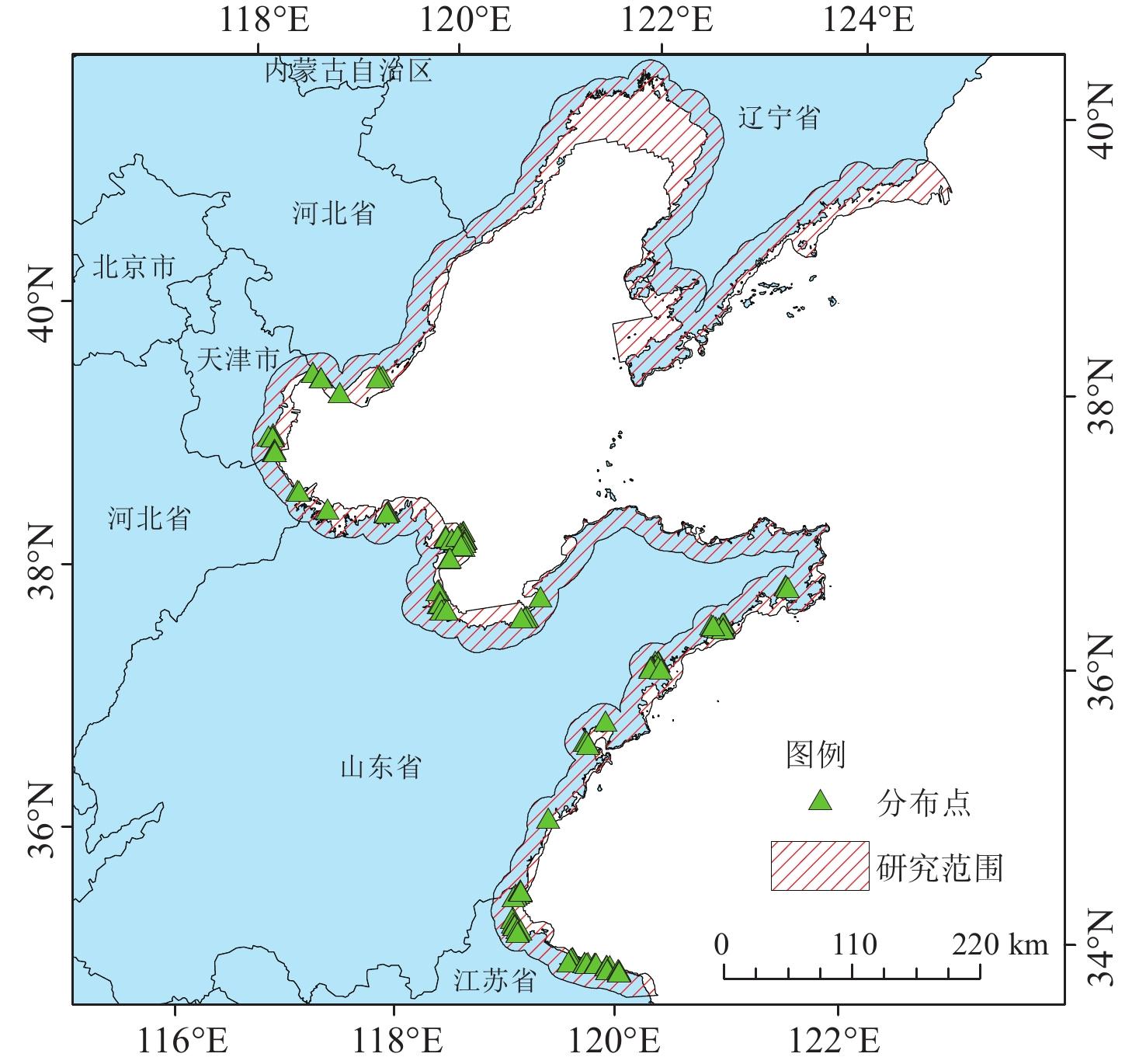
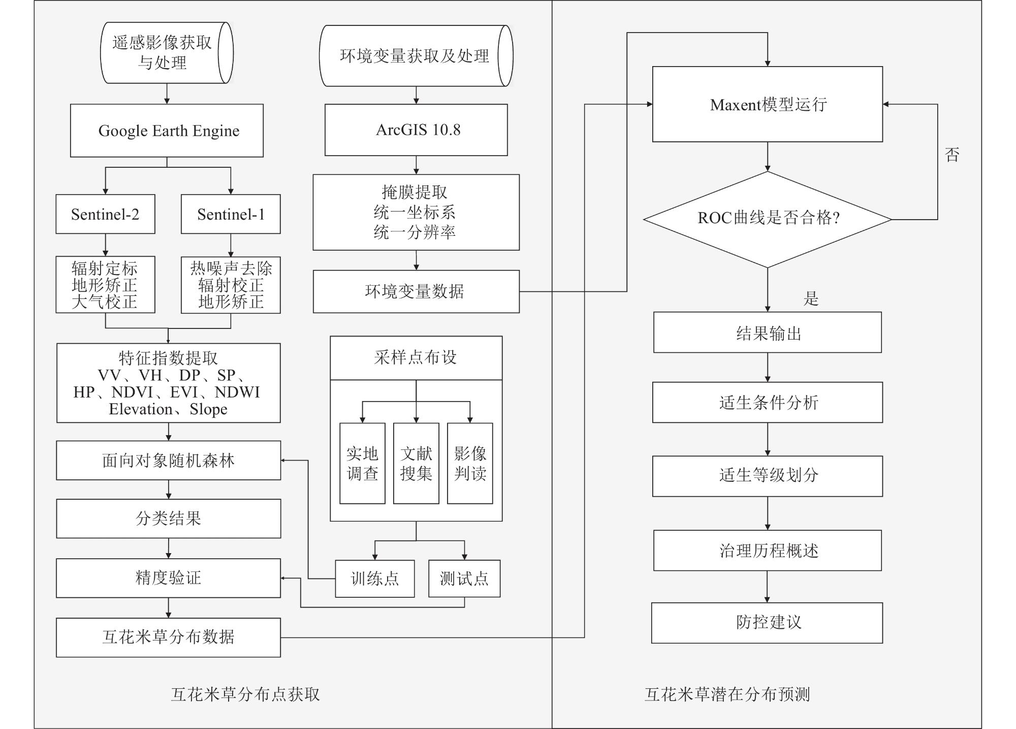
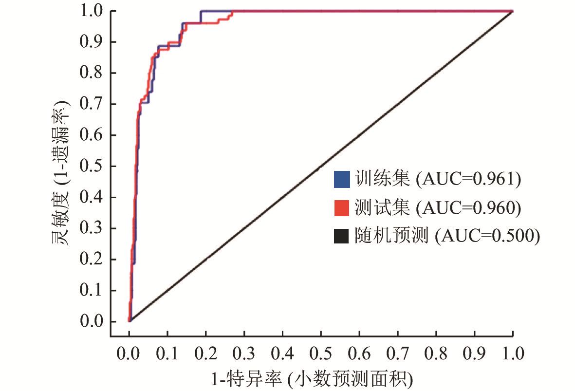
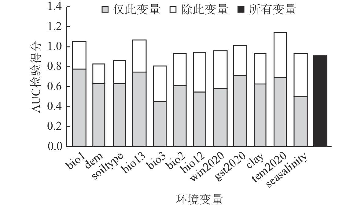
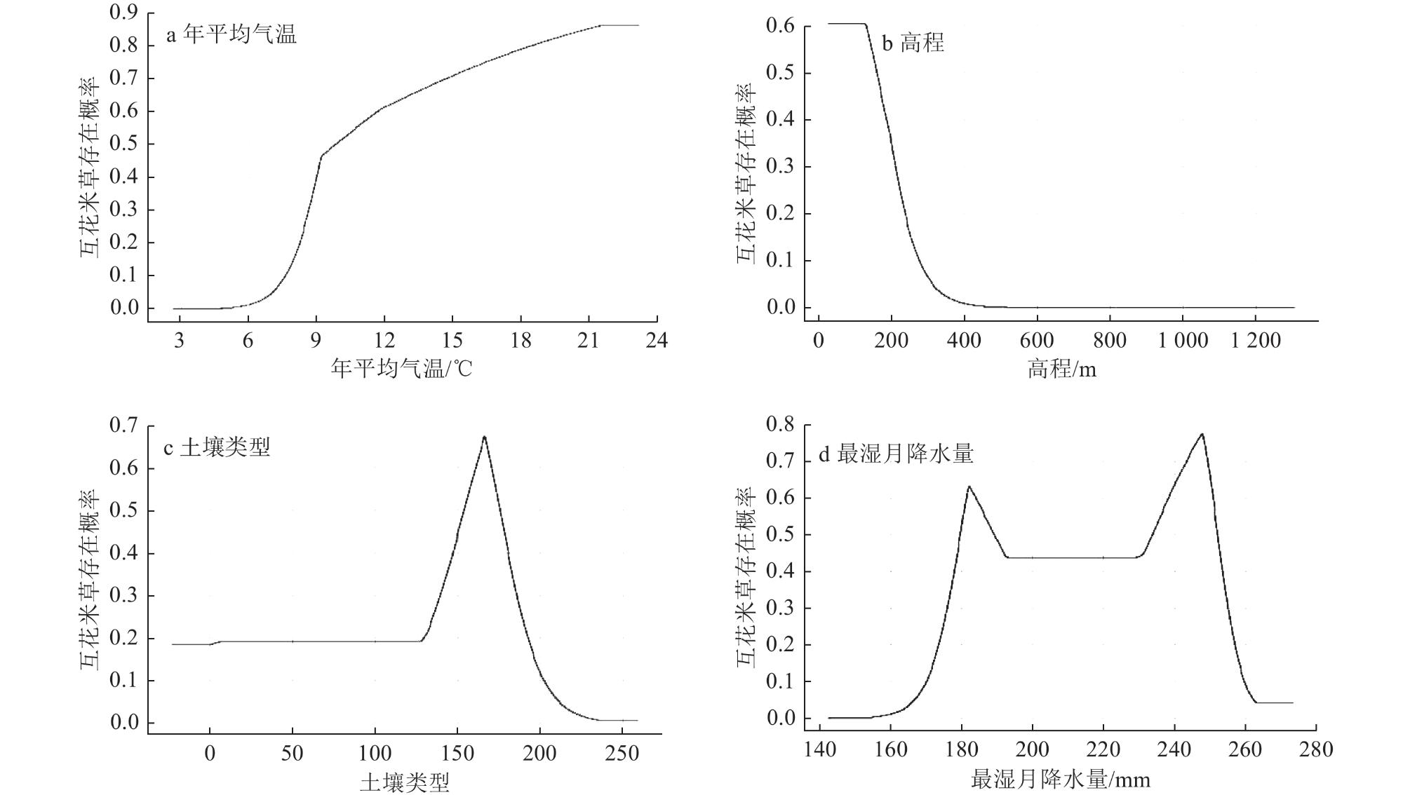
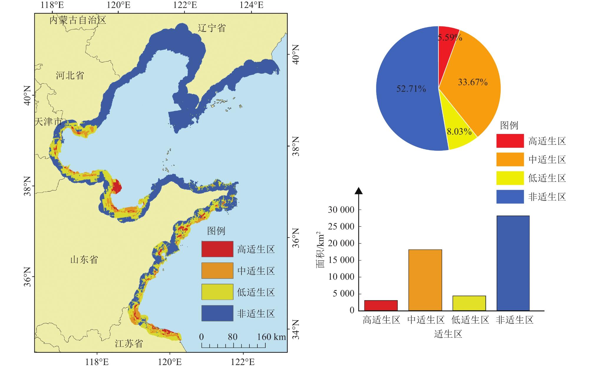
As an invasive species, Spartina alterniflora has widely spread along China's coastal areas, posing a severe threat to coastal ecological security. Due to its rapid expansion and strong adaptability to intertidal zones, it has become one of the most aggressive invasive plant species in China’s coastal ecosystems. The warm-temperate coastal region, as an essential economic, political, and cultural zone in China, plays a crucial role in national development. Maintaining the ecological stability of this region is therefore of great significance. Understanding the current distribution and potential spread of Spartina alterniflora is essential for implementing effective control strategies. This study utilized Sentinel-1/2 remote sensing images and the Google Earth Engine (GEE) platform to obtain the distribution points of Spartina alterniflora in the warm-temperate coastal region of China in 2023. Based on these data, along with 35 environmental variables, the MaxEnt model was employed to predict the potential distribution of Spartina alterniflora in the study area. The model achieved high classification accuracy, with an overall accuracy of 90.1% and a Kappa coefficient of 0.885. The results revealed that the total distribution area of Spartina alterniflora in the warm-temperate coastal zone of China in 2023 was approximately 74.83 km². Among the provinces, Shandong province exhibited the most extensive distribution, covering about 62 km². Jiangsu province and Hebei province followed with distribution areas of approximately 6.86 km² and 4.25 km², respectively, while Tianjin had the smallest distribution area at approximately 1.72 km². The suitability analysis categorized the study area into four zones: highly suitable (5.59%), moderately suitable (33.67%), lowly suitable (8.03%), and unsuitable (52.71%). The suitable regions were mainly concentrated in the southern part of Hebei Province, Tianjin, Shandong Province, Jiangsu Province, and the coastal mudflat regions of Dalian and Dandong in Liaoning Province. The key environmental variables influencing Spartina alterniflora growth were mean annual temperature (bio1), elevation (dem), soil type (soiltype), and precipitation in the wettest month (bio13). The optimal conditions for Spartina alterniflora growth in the warm-temperate coastal region include a mean annual temperature between 11.0 and 21.5 °C, low-lying coastal mudflat areas, coastal saline soil, and wettest-season precipitation ranging from 180-190 mm and 230-250 mm. The results indicate that Spartina alterniflora has a vast potential distribution area in the warm-temperate coastal region of China, with a notable trend of northward expansion. This continued spread poses a significant ecological threat by altering native wetland ecosystems, reducing biodiversity, and disrupting coastal hydrodynamics. If left unmanaged, the invasion of Spartina alterniflora could lead to severe degradation of wetland habitats and loss of ecosystem services. Therefore, it is critical to strengthen monitoring, prevention, and control measures to mitigate the invasion of Spartina alterniflora. Additionally, further research should focus on evaluating the effectiveness of different eradication strategies and assessing the long-term ecological impacts of its spread.
Xing Junfeng , Wang Qi , Liu Haojie , Cui Guoli , Jia Mingming , Yu Hao , Xiao Yihua , Li Huiying . Prediction of potential distribution of Spartina alterniflora in warm temperate coastal areas of China based on Sentinel-1/2 and MaxEnt model[J]. Wetland Science, 2025 , 23(2) : 227 -237 . DOI: 10.13248/j.cnki.wetlandsci.20240095
1 Feature dataset特征数据集 |
| 数据来源 | 特征子集 | 变量简称 |
| Sentinel-1 | 雷达特征 | VV、VH、DP、SP、HP |
| Sentinel-2 | 物候特征 | NDVI、EVI |
| Sentinel-2 | 时间特征 | NDWI |
| SRTM | 地形特征 | Elevation、Slope |
2 Environmental variable dataset环境变量数据集 |
| 数据集 | 环境变量 | 描述 | 单位 | 数据集 | 环境变量 | 描述 | 单位 | |
| 生物气候 | bio1 | 年平均气温 | ℃ | 生物气候 | bio18 | 最热季降水量 | mm | |
| bio2 | 平均日较差 | ℃ | bio19 | 最冷季降水量 | mm | |||
| bio3 | 等温性 | 无量纲 | gst2020 | 年平均地温 | ℃ | |||
| bio4 | 温度季节性变动系数 | 无量纲 | ssd2020 | 年日照时数 | h | |||
| bio5 | 最热月的最高温度 | ℃ | tem2020 | 年平均气温 | ℃ | |||
| bio6 | 最冷月的最低温度 | ℃ | win2020 | 年平均风速 | km/h | |||
| bio7 | 温度年较差 | ℃ | maxwin | 年最高风速 | km/h | |||
| bio8 | 最湿季平均温度 | ℃ | 土壤 | soiltype | 土壤类型 | 无量纲 | ||
| bio9 | 最干季平均温度 | ℃ | ece | 土壤电导率 | dS/m | |||
| bio10 | 最热季平均温度 | ℃ | teb | 交换性盐基 | % | |||
| bio11 | 最冷季平均温度 | ℃ | esp | 可交换钠盐 | % | |||
| bio12 | 年降水量 | mm | CaSO4 | 硫酸盐含量 | % | |||
| bio13 | 最湿月降水量 | mm | CaCO3 | 碳酸盐含量 | % | |||
| bio14 | 最干月降水量 | mm | OC | 有机碳含量 | % | |||
| bio15 | 降水季节性变动系数 | 无量纲 | clay | 黏土含量 | % | |||
| bio16 | 最湿季降水量 | mm | 海洋 | seatemp | 海表温度 | ℃ | ||
| bio17 | 最干季降水量 | mm | seasalinity | 海洋盐度 | % | |||
| 地形 | dem | 高程 | m |
3 Analysis results of environmental variable contribution and importance环境变量贡献度和重要性分析结果 |
| 变量编号 | 环境变量 | 贡献率/% | 排列重要性/% |
| bio1 | 年平均气温 | 33.3 | 1.5 |
| dem | 高程 | 23.0 | 12.5 |
| soiltype | 土壤类型 | 13.3 | 6.1 |
| bio13 | 最湿月降水量 | 5.0 | 7.0 |
| bio3 | 季节等温性 | 3.3 | 2.1 |
| bio2 | 平均日较差 | 3.3 | 18.9 |
| bio12 | 年降水量 | 2.0 | 2.2 |
| win2020 | 平均风速 | 2.0 | 8.0 |
| seatemp | 海表温度 | 1.8 | 4.5 |
| clay | 黏土含量 | 1.6 | 2.2 |
| maxwin | 最大风速 | 1.2 | 0.6 |
| seasalinity | 海洋盐度 | 1.1 | 0.9 |
| 1 |
| 2 |
| 3 |
| 4 |
| 5 |
| 6 |
| 7 |
| 8 |
| 9 |
| 10 |
| 11 |
| 12 |
| 13 |
| 14 |
| 15 |
| 16 |
| 17 |
| 18 |
| 19 |
| 20 |
| 21 |
| 22 |
| 23 |
| 24 |
| 25 |
| 26 |
| 27 |
| 28 |
| 29 |
| 30 |
| 31 |
| 32 |
| 33 |
| 34 |
| 35 |
| 36 |
| 37 |
| 38 |
| 39 |
| 40 |
| 41 |
| 42 |
| 43 |
| 44 |
| 45 |
| 46 |
| 47 |
| 48 |
/
| 〈 |
|
〉 |