LIU Jing-Shuang, YU Jun-Bao, WANG Jin-Da, LIU Shu-Xia
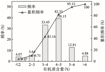
The spatial variation law of soil organic carbon(SOC) and the content variation of SOC in different tillage periods in typical black soil distribution area of China were studied. The results show that, with the increase of latitude, the average total black soil organic carbon content increases from 11.43 g/kg to 20.83 g/kg, the organic carbon compositions content and HA/FA ratio show a increased trend. With soil profile depth increased, the black soil total organic carbon and HA-C, FA-C, HU-C contents are decreased, the black soil total organic carbon contents in A, AB and C layers are 16.04-40.28 g/kg, 8.04-13.82 g/kg, 4.84-9.13 g/kg, respectively. The ratio changes of FA-C/SOC, HA-C/SOC and HU-C/SOC are different in soil profiles from A to B layer, the ratio of HA-C/SOC is to reduce gradually with soil profile depth increased, and the ratios of FA-C/SOC and HU-C/SOC are to increase gradually with soil profile depth increased, HA-C is substituted for FA-C and HU-C gradually. It is shown that ability of humus wholly decayed is to reduce with soil profile depth change. Black soil total organic carbon and its compositions content decrease rapidly before 50 years tillage, then decrease slowly. After 130 years tillage, the soil organic carbon content is relative stable basically.