Guangdong-Hong Kong-Macao greater bay area (GBA)
The high-speed railways network provides rapid transit service for inter-city passenger movements. The integration between high-speed railways (HSR) station and urban (intra-city) public transport plays a vital role in regional formation. Based on the passengers' travel experience, this study developed a theoretical framework of passenger-centered integrated transport. Moreover, this framework was tested with results of observational surveys conducted at three important HSR stations along the Hong Kong-Shenzhen-Guangzhou HSR line. With regard to the proposal of fostering the Guangdong-Hong Kong-Macao Greater Bay Area, the findings underline the importance of fostering seamless intermodal integration in enabling the formation of the Greater Bay Area. The results show that the Hong Kong HSR station distinguishes itself by scoring high in the "lowest level integration of information" in a cosmopolitan setting. In terms of the "moderate level integration of facilities and services," both Hong Kong and Shenzhen HSR stations are well connected to nearby shopping malls to enhance the passenger experience. In terms of the "highest level of integration of ticketing and fares," Shenzhen and Guangzhou HSR stations have made better use of information and communication technologies in ticketing; yet, none of the three stations offer any fare integration. Based on the research findings, specific suggestions on improving intermodal transfers are put forward based on the three levels of the transport integration ladder.
The Guangdong-Hong Kong-Macao Greater Bay Area is one of the most urbanized city regions in the world. This study aimed to understand the development of the Guangdong-Hong Kong-Macao Greater Bay Area by applying the theoretical framework of mega-city region. We regarded the Guangdong-Hong Kong-Macao Greater Bay Area as a mega-city region and analyzed its spatial structure from four dimensions: intraregional boundaries, functional network, core area, and regional infrastructure integration. Four development trends were identified: (1) Boundary effect is reducing remarkably and border areas will grow rapidly inside the Greater Bay Area. (2) Industrial clusters become functional areas in a functional network, replacing cities to be the basic unit in global competition. (3) Two core areas can be identified, including the Guangzhou-Foshan core area and the Hong Kong-Shenzhen core area. (4) Rail transit station density tends to increase and a global transportation hub is emerging, which make it convenient for people in the Greater Bay Area to share transportation hub and public service facilities. In the end, the article presents a vision of spatial structure for the Guangdong-Hong Kong-Macao Greater Bay Area, concluding that this mega-city region will form a new structure of 'two cores and functional areas.'
Urban population data are the basic data in various social and economy fields, and high-resolution spatialized urban population data are of great importance for the research in such fields. In this article, multi-source remote sensing data were used to extract the urban impervious surface changes in the Guangdong-Hong Kong-Macao (GHM) Greater Bay Area at a spatial resolution of 30 meters from 2007 to 2015. The Dasymetric mapping method was used to spatialize the population at different times to a resolution of 30 meters. We finally estimated the gridded population density distribution of 30 meters resolution, and analyzed the spatiotemporal changes of the urban population in the GHM Greater Bay Area from 2007 to 2015. Validated with Google Earth time series high-resolution images, the accuracy of the derived urban impervious surfaces in GHM is generally above 80%. Using the county-level demographic data, the consistency between the estimated population and the statistical data in the GHM Greater Bay Area was analyzed, and the correlation coefficient (R2) was generally above 0.7. Finally, according to the spatial distribution of urban population and the change of population density, urban expansion and population increase patterns of different cities in the GHM Greater Bay Area were analyzed. The research shows that the urban population of the GHM has special spatiotemporal characteristics: (1) Stable population distribution is observed for Hong Kong and Macao, but other urban areas have experienced expansion of population to different extents and in different directions. The population expansion of Guangzhou, Shenzhen, and Dongguan is most obvious. (2) The spatial distribution of urban population in GHM shows multi-scale and multi-center characteristics. In general, the population of GHM is concentrated in the core area centered at the Pearl River Estuary. The Zhaoqing, Jiangmen, and Huizhou areas are sparsely populated. In the core area, the distribution of urban population shows the characteristics of multi-center distribution on both urban and metropolitan scales. Hong Kong and Guangzhou have multiple urban centers, while Hong Kong, Macao, Shenzhen, and Guangzhou are the centers of the GHM. These four centers can drive the overall development of the GHM Greater Bay Area.
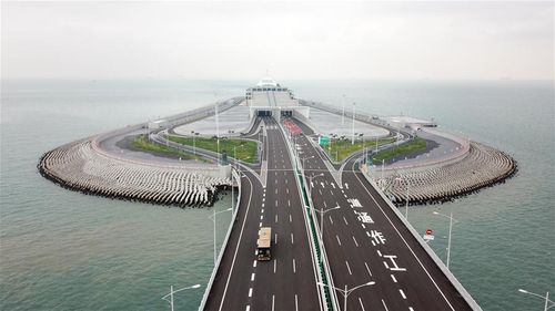
The concept of megalopolis, since its original inception six decades ago, has inspired many new terms that mainly describe large-scale urbanized forms such as megaregions and polycentric urban regions. However, recent studies have increasingly focused on the two key functions that megalopolises act as an incubator of new ideas and trends and as a hub that articulates knowledge exchange at the megalopolitan, national, and global scales. While the recent studies have mainly analyzed the functional aspects of megalopolis based on China's Yangtze River Delta region, this paper investigates the evolving process and mechanisms of knowledge collaboration within and beyond Guangdong-Hong Kong-Macao Greater Bay Area (GBA) - one of the most promising and vibrant megalopolises in China. In addition, the GBA megalopolis is unique because it contains Hong Kong and Macao, which have a different political system from China's mainland. Drawing upon a dataset of publications that were indexed in Web of Science Core Collection during the 1990-2016 period, this paper uses the Gini coefficient to measure the degree of knowledge polycentricity of the GBA megalopolis. Here, knowledge polycentricity is further classified into attribute polycentricity of knowledge production and functional polycentricity of knowledge collaboration within and beyond the GBA megalopolis. Whereas the attribute polycentricity refers to the distribution inequality of the total publications of GBA cities, the functional polycentricity represents the distribution inequality of GBA cities' knowledge collaboration at different geographical scales. Our empirical results show: (1) knowledge production of the GBA megalopolis as a whole has experienced a robust and continuous growth. The degrees of both attribute polycentricity and functional polycentricity have also been on the increase in general, although there are some fluctuations in early years and some deviations in recent years. During the ten years after Hong Kong and Macao returned to China (the 2000-2010 period), the degree of knowledge polycentricity of the GBA megalopolis especially enjoyed the fastest rise; (2) The degree of functional polycentricity decreased with the expansion in the geographical scales at which it is measured, confirming the findings of previous studies that functional polycentricity is scale-dependent. Moreover, we find that the degree of functional polycentricity becomes more fluctuated at the global scale while it tends to increase continuously at the megalopolitan scale; (3) The evolving process of knowledge polycentricity of the GBA megalopolis is influenced by institutional proximity, geographical proximity and status proximity between cities. Specifically, the mobility of researchers, the collaboration of universities and research institutes, and the coordination of local governments are three major forces promoting the evolution of knowledge polycentricity of the GBA megalopolis. Overall, the increasing knowledge polycentricity would be of significance for the GBA megalopolis to form a knowledge-driven region of collective collaboration.
The Guangdong-Hong Kong-Macao Greater Bay Area is a new geographical concept arising from the enhanced cooperation of the Pearl River Delta Economic Zone under China's Belt and Road Initiative. As a new global bay area, how to make a theoretical breakthrough in neoliberalism framework and explore the development pathway in line with the socialist market economic system is an important issue that policymakers and planners need to think about. Based on a systematic review of the existing theories in urban agglomeration, regional growth pole theory, the cluster theory in new economic geography, and the global production network theory, this article seeks for a theoretical framework and grounding for understanding the development issues in the Greater Bay Area. In line with the existing advantages of the Greater Bay Area, this article identifies the strategic positioning and development pathway for the area, and argues that creating a new development model of endogenous growth with indigenous innovation is the first development priority for the Greater Bay Area. That is, through deepening the cooperation between Guangdong, Hong Kong, and Macau under "one country, two systems, three tariff zone," the Greater Bay Area could first achieve the transformation and upgrading in advanced manufacturing industry and secure a strategic position as an important regional hub in the global production network. Second, the Greater Bay Area should also use its own strengths in education, scientific research, and international financial services to develop China's innovation hub and global financial center with strong property rights, compliance, and rule-based economic system.
Most recently, China has proposed the Belt and Road initiative in an effort to establish a form of multilateral trade cooperation mechanism. This initiative is meaningful for the construction of a healthy global economic structure and the breaking of US-initiated hegemony global economic structure. The notion of "Guangdong-Hong Kong-Macao Greater Bay Area" is a refresh regional concept developed exactly in such a context. In this sense, this notion is inevitably imbued with the meaning of political geography. This article therefore argues that studies related to the Guangdong-Hong Kong-Macao Greater Bay Area should not be limited to discussions within segregated practical disciplines, but considered on the macro-level, such as with the perspectives of political geography. In so doing, this article puts forward some suggestions from the lens of modern "vertical-horizontal" spatial management system, the integration of geo-cultures, and geo-economy. First, this article insists that the proposal of the concept of bay economy itself is a type of spatial management thoughts that stresses "upscaling." The development of the Guangdong-Hong Kong-Macao Greater Bay Area is under a rather complex and multi-scale space structure that should pay attention to the competitive and cooperative relations among different cities and regions. It is important to adjust the scale, in particular to the national scale to tackle problems faced in the process of integrating the development of the whole area. Second, this article argues that there is a potential for weakening the integration of various geo-cultures in the process of developing the Guangdong-Hong Kong-Macao Greater Bay Area. It is very important to discuss how to deal with the "identity crisis" between Hong Kong and the mainland of China, which, to a significant extent, provides stable social environment for the development of the Guangdong-Hong Kong-Macao Greater Bay Area. Third, this article argues that it is important to put the development of the Guangdong-Hong Kong-Macao Greater Bay Area into the framework of geo-economy, which underlines the importance of the requirement of the state power on economic development as well as the importance of economic development on power exercises. Finally, this article proposes an agenda to generate suggestions on the scientific development of the Guangdong-Hong Kong-Macao Greater Bay Area from multiple perspectives in other disciplines in the future.
The Guangdong-Hong Kong-Macao Greater Bay Area with economic geographical advantages is deemed to be the growth point that captivated the world for its impetus to the global economy. This article focuses on the nine main cities of the Pearl River Delta, analyzing the mutual influences among industry-population-space during the rapid development process of this urban agglomeration by constructing a vector auto regressive model and impulse response function and variance decomposition analysis. The results show that: The absorption effect for population in the development of industry in the urban agglomeration of the Pearl River Delta faded in the late stage. The acceleration that industry benefitted from population aggregation weakened in the middle and late periods. The spatial expansion effects on population aggregation were limited and have become negative in the late period. It concludes that in general a short-term mutual promoting development mechanism between industry-population-space was formed, but a long-term mechanism is yet to be developed. In order to promote the development of the Greater Bay Area of Guangdong-Hong Kong-Macao, the urban agglomeration of the Pearl River Delta should attract highly-qualified workforce on the basis of industrial upgrading, plan spatial growth according to the population aggregation, and construct a multilevel synergistic industrial space with complementary products and services. With these measures, the overall aims are to strengthen the synergistic development among industry, population, and space and promote the development of the Greater Bay Area of Guangdong-Hong Kong-Macao.
To study the coupling between construction land expansion and urban heat island(UHI)expansion in Guangdong-Hong Kong-Macao Greater Bay, it is of great significance and scientific value to improve the ecological environment of the Greater Bay and realize the healthy development of urbanization. In this paper, the Guangdong-Hong Kong-Macao Greater Bay was used as the research area. We selected remote sensing image data and surface temperature data in 2000, 2008 and 2016 to extract construction land in the Greater Bay, classify heat island intensity level and identify UHI regions. Then this paper used overall coupling model and spatial coupling model to reveal the coupling relationship between the construction land expansion and UHI expansion of the Greater Bay in different periods. The overall coupling situation was reflected by measuring the spatial overlap and change track consistency of land expansion and UHI expansion. And the spatial coupling relationship between the land expansion and UHI expansion was studied by using the revised coordination coefficient model. The results showed that: (1) From 2000 to 2016, the trend of construction land expansion and UHI expansion in the Greater Bay was synchronous. And the expansion rate between 2008 and 2016 was faster than that from 2000 to 2008; (2) The area of UHI increased constantly, and multiple UHI centers appeared. On the two sides of the Pearl River Estuary, an inverted "U" shaped UHI belt has been formed, which linked Zhongshan, Foshan, Guangzhou, Dongguan, Shenzhen and Hongkong; (3) The overall coupling situation of the construction land expansion and UHI in the Greater Bay was constantly strengthening. By 2016, the distance between the gravity center of the two types of indexes reached the nearest distance in the study period, and the overall coupling situation was also the greatest at this time. (4) During the research period, there was no serious imbalance of construction land expansion and UHI expansion in the Greater Bay. In the two types of index coupling types in the Greater Bay area, the space coupling categories of construction land expansion and UHI expansion were mainly coupling category, approximate coupling category and slightly uncoupling category. The degree of space coupling was high. And there was little change in the number of each category, but the number of "double high" coupled units was greatly increased.