
土地覆盖分类体系分析和总结
|
臧明润(2001-),男,博士研究生,主要从事生态学、地理信息科学研究。Email: zangmr@foxmail.com。 |
Copy editor: 陈庆
收稿日期: 2022-09-15
修回日期: 2023-06-19
网络出版日期: 2026-06-03
基金资助
国家重点研发计划项目“面向开放科学的国际地球观测系统互操作体系研究与示范”(2019YFE0126400)
Analysis and summary of land cover classification systems
Received date: 2022-09-15
Revised date: 2023-06-19
Online published: 2026-06-03
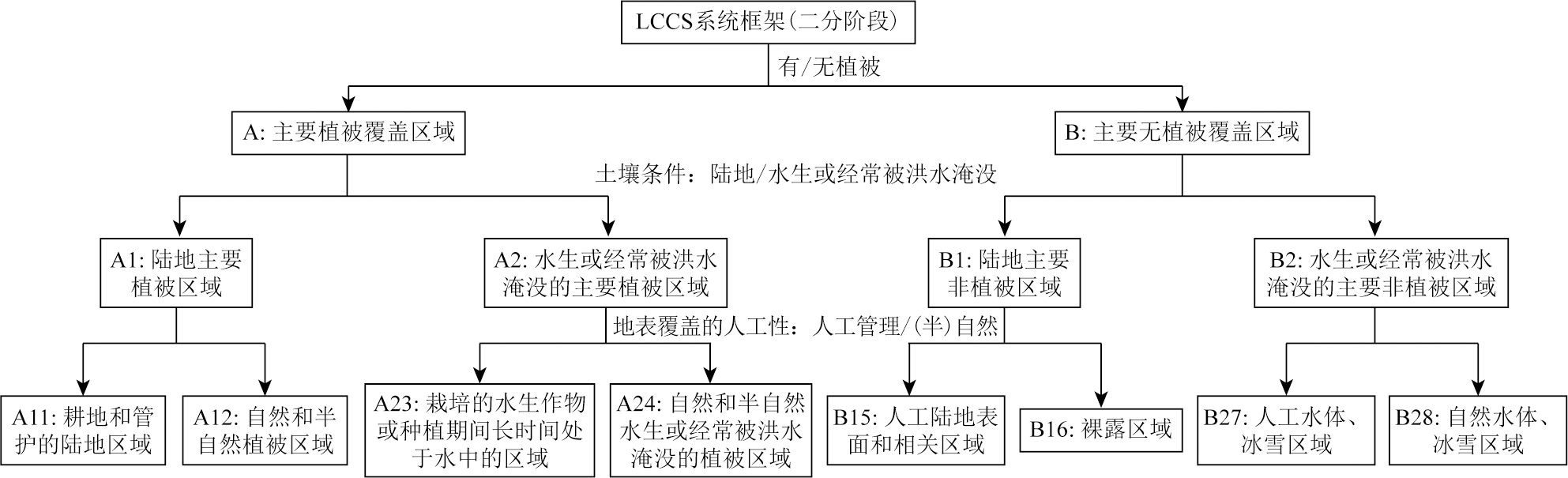
土地覆盖分类体系是土地覆盖研究中的重要内容。该文总结了9种主要土地覆盖分类体系,展示了分类体系和相应数据产品,分析了体系之间的区别和联系,讨论了土地覆盖分类体系精细程度,以及分类体系、空间分辨率、空间覆盖范围的关系,讨论了分类体系之间的语义一致性。论文认为土地覆盖分类体系(land cover classification system,LCCS)和全球土地覆盖精细分辨率观测与监测数据(finer resolution observation and monitoring of global land cover,FROM-GLC)分类体系在精细化分类方面具有优势,高空间分辨率精细分类存在较大技术挑战和实现难度; 目前分类体系之间在逻辑关系、精细分类、名称定义、代码等多方面,存在明显的语义不一致现象; 最后总结指出全球土地覆盖分类研究存在全球化和区域化并存、分类更加精细、产品精度更高、时间间隔和空间分辨率更加细致的发展趋势,数据产品的语义不一致性还需改进,未来需在加强分类体系的兼容性、实现数据产品的共享互操作方面提出解决方案。
臧明润 , 廖远鸿 , 陈舟 , 白玉琪 . 土地覆盖分类体系分析和总结[J]. 自然资源遥感, 2025 , 37(6) : 22 -40 . DOI: 10.6046/zrzyyg.2022367
Land cover classification systems constitute a significant aspect of land cover research. This study summarized nine major land cover classification systems. It presented these classification systems along with their relevant data products and analyzed the differences and connections between them. Moreover, this study discussed the relationship of their fineness with spatial resolution and coverage, as well as their semantic consistency. The results indicate that LCCS and Finer Resolution Observation and Monitoring of Global Land Cover(FROM-GLC) excel in fine-scale classification but face technical challenges and implementation difficulties in fine-scale classification based on high spatial resolution data. Current classification systems exhibit significant semantic inconsistencies in logical relationships, fine-scale classification, nomenclature, and code. Global land cover classification research shows the following development trends: the coexistence of globalization and regionalization, finer-scale classification, higher product accuracy, and more detailed temporal and spatial resolution. The semantic consistency of data products needs to be enhanced by strengthening the compatibility of classification systems and finding solutions to data product sharing and interoperability.
表1 USGS Anderson土地覆盖分类体系Tab.1 USGS Anderson land cover classification system |
| 一级类 | 二级类(编码+类型名) | |
|---|---|---|
| 编码 | 类型名 | |
| 1 | 城镇或建成区(urban or built-up land) | 11住宅用地,12商服用地,13工业用地,14交通、通信和公共设施用地,15工商综合体,16城镇或建成区混合体,17其他城镇或建成区 |
| 2 | 农业用地(agricultural land) | 21耕地和牧场,22果园、园林、葡萄园、苗圃和园艺用地,23圈养场,24其他农用地 |
| 3 | 草地(rangeland) | 31草本草地,32灌木和灌丛草地,33混合草地 |
| 4 | 林地(forest land) | 41落叶林地,42常绿林地,43混合林地 |
| 5 | 水体(water) | 51河流和沟渠,52湖泊,53水库,54海湾和河口 |
| 6 | 湿地(wetlands) | 61有林地覆盖的湿地,62无林地覆盖的湿地 |
| 7 | 荒地(barren land) | 71干旱盐碱地,72海滩,73沙地(不包括海滩),74裸岩,75露天矿、采石场和采砂场,76过渡带,77混合荒地 |
| 8 | 苔原(tundra) | 81灌木与灌丛苔原,82草本苔原,83裸地苔原,84湿苔原,85混合苔原 |
| 9 | 冰川或永久积雪(perennial snow or ice) | 91永久积雪,92冰川 |
表2 NLCD 2019美国国家土地覆盖分类体系Tab.2 NLCD 2019 U.S. national land cover classification system |
| 一级类(编码+类型名) | 二级类(编码+类型名) |
|---|---|
| 1水体(water) | 11开阔水域,12永久冰川/积雪 |
| 2开发用地(developed) | 21已开发的、开放空间,22发达的、低强度的,23发达的、中等强度的,24发达的、高强度的 |
| 3贫瘠土地(barren) | 31贫瘠土地(裸岩/沙地/裸土) |
| 4森林(forest) | 41落叶林,42常绿森林,43混交林 |
| 5灌丛地(shrubland) | 51矮生灌丛,52灌木/灌木丛 |
| 7草本植被(herbaceous) | 71草地/草本植物,72灌木/草本植物,73地衣,74苔藓 |
| 8种植/栽培地(planted/cultivated) | 81牧场/干草,82栽培作物 |
| 9湿地(wetlands) | 90有林湿地,95草洲 |
表3 GeoCover LC全球土地覆盖分类体系Tab.3 GeoCover LC global land cover classification system |
| 编码 | 类型名 |
|---|---|
| 1 | 落叶林(forest, deciduous) |
| 2 | 常绿森林(forest, evergreen) |
| 3 | 灌木/灌木丛(shrub/scrub) |
| 4 | 草原(>10%地面覆盖)(grassland (>10% ground cover)) |
| 5 | 贫瘠/极少植被(<10%地面覆盖)(barren/minimal vegetation (<10% ground cover)) |
| 6 | 人造的其他城市建成地(man made-other, urban/built up) |
| 7 | 一般农业(agriculture, general) |
| 8 | 稻米/稻谷农业(agriculture rice/paddy) |
| 9 | 永久/草本湿地(wetland, permanent/herbaceous) |
| 10 | 红树林湿地(wetland, mangrove) |
| 11 | 水体(water) |
| 12 | 永久或几乎永久的冰和/或雪(permanent or nearly permanent ice and/or snow) |
| 13 | 云/云影/无数据(cloud/cloud shadow/no data) |
表4 CORINE CLC土地覆盖分类体系Tab.4 CORINE CLC land cover classification system |
| 一级类 | 二级类 | 三级类 |
|---|---|---|
| 1人工表面(artificial surfaces) | 1.1城镇建筑物 | 1.1.1连续的城市结构,1.1.2不连续的城市结构 |
| 1.2工业、商业和交通运输用地 | 1.2.1工业或商业单位,1.2.2公路和铁路网络及相关土地,1.2.3港口区,1.2.4机场 | |
| 1.3矿山、垃圾场和建筑工地 | 1.3.1矿物提取点,1.3.2垃圾场,1.3.3建筑工地 | |
| 1.4人工非农业用地 | 1.4.1绿色城市地区,1.4.2运动和休闲设施 | |
| 2农业用地(agricultural areas) | 2.1耕地 | 2.1.1非灌溉耕地,2.1.2永久灌溉土地,2.1.3稻田 |
| 2.2多年生作物 | 2.2.1葡萄园,2.2.2果树和浆果种植园,2.2.3橄榄园 | |
| 2.3牧场 | 2.3.1牧草 | |
| 2.4其他农业 用地 | 2.4.1与长期作物相关的一年生作物,2.4.2.复合栽培,2.4.3土地主要用于农业、自然植被面积很大,2.4.4农林区 | |
| 3林地和半自然用地(forests and semi-natural areas) | 3.1林地 | 3.1.1阔叶林,3.1.2针叶林,3.1.3混交林 |
| 3.2灌木或草本植物 | 3.2.1自然草场,3.2.2沼泽和荒地,3.2.3硬叶植物,3.2.4过渡性林地灌木 | |
| 3.3少植被或无植被覆盖的空地 | 3.3.1海滩、沙丘和沙地或没有植被,3.3.2裸岩,3.3.3植被稀疏的地区,3.3.4烧毁区域,3.3.5冰川和永久的雪 | |
| 4湿地(wetlands) | 4.1内陆湿地 | 4.1.1内陆沼泽,4.1.2泥炭沼泽 |
| 4.2沿海湿地 | 4.2.1盐沼,4.2.2盐碱地,4.2.3潮间带 | |
| 5水体(water bodies) | 5.1内陆水体 | 5.1.1水道,5.1.2水体 |
| 5.2海水 | 5.2.1沿海潟湖,5.2.2河口,5.2.3海和洋 |
表5 IGBP和UMD全球土地覆盖分类体系Tab.5 IGBP and UMD global land cover classification systems |
| 编码 (IGBP) | 类型名 | |
|---|---|---|
| IGBP | UMD | |
| 0 | 水体(water bodies) | 水体(water bodies) |
| 1 | 常绿针叶林(evergreen needleleaf forests) | 常绿针叶林(evergreen needleleaf forests) |
| 2 | 常绿阔叶林(evergreen broadleaf forests) | 常绿阔叶林(evergreen broadleaf forests) |
| 3 | 落叶针叶林(deciduous needleleaf forests) | 落叶针叶林(deciduous needleleaf forests) |
| 4 | 落叶阔叶林(deciduous broadleaf forests) | 落叶阔叶林(deciduous broadleaf forests) |
| 5 | 混交林(mixed forests) | 混交林(mixed forests) |
| 6 | 郁闭灌木林(closed shrublands) | 郁闭丛林或灌木林(closed bushlands or shrubland) |
| 7 | 稀疏灌木林(open shrublands) | 稀疏灌木林(open shrublands) |
| 8 | 有林草原(woody savannas) | 林地(woodlands) |
| 9 | 稀树草原(savannas) | 有林草原/灌木林(wooded grasslands/shrublands) |
| 10 | 草原(grasslands) | 草原(grasslands) |
| 11 | 永久湿地(permanent wetlands) | — |
| 12 | 农田(croplands) | 农田(croplands) |
| 13 | 城镇与建成区(urban and built-up) | 城镇与建成区(urban and built-up) |
| 14 | 农田/自然植被混合区(cropland natural vegetation mosaics) | — |
| 15 | 永久冰雪(snow and ice) | — |
| 16 | 裸地或稀疏植被(barren or sparsely vegetated) | 裸地(barren) |
表6 基于IGBP,UMD,LAI,BGC和PFT的MODIS土地覆盖分类体系Tab.6 MODIS land cover classification system based on IGBP, UMD, LAI, BGC, PFT |
| IGBP | UMD | LAI | BGC | PFT | ||||||
|---|---|---|---|---|---|---|---|---|---|---|
| 编码 | 类型名 | 编码 | 类型名 | 编码 | 类型名 | 编码 | 类型名 | 编码 | 类型名 | |
| 0/17① | 水体(water bodies) | 0 | 水体(water bodies) | 0 | 水体(water bodies) | 0 | 水体(water bodies) | 0 | 水体(water bodies) | |
| 1 | 常绿针叶林(evergreen needleleaf forests) | 1 | 常绿针叶林(evergreen needleleaf forests) | 7 | 常绿针叶林(evergreen needleleaf forests) | 1 | 常绿针叶林(evergreen needleleaf forests) | 1 | 常绿针叶林(evergreen needleleaf forests) | |
| 2 | 常绿阔叶林(evergreen broadleaf forests) | 2 | 常绿阔叶林(evergreen broadleaf forests) | 5 | 常绿阔叶林(evergreen broadleaf forests) | 2 | 常绿阔叶林(evergreen broadleaf forests) | 2 | 常绿阔叶林(evergreen broadleaf forests) | |
| 3 | 落叶针叶林(deciduous needleleaf forests) | 3 | 落叶针叶林(deciduous needleleaf forests) | 8 | 落叶针叶林(deciduous needleleaf forests) | 3 | 落叶针叶林(deciduous needleleaf forests) | 3 | 落叶针叶林(deciduous needleleaf forests) | |
| 4 | 落叶阔叶林(deciduous broadleaf forests) | 4 | 落叶阔叶林(deciduous broadleaf forests) | 6 | 落叶阔叶林(deciduous broadleaf forests) | 4 | 落叶阔叶林(deciduous broadleaf forests) | 4 | 落叶阔叶林(deciduous broadleaf forests) | |
| 5 | 混交林(mixed forests) | 5 | 混交林(mixed forests) | — | — | — | — | — | — | |
| — | — | — | — | 2 | 灌木林(shrublands) | — | — | 5 | 灌木(shrub) | |
| 6 | 郁闭灌木林(closed shrublands) | 6 | 郁闭灌木林(closed shrublands) | — | — | — | — | — | — | |
| 7 | 稀疏灌木林(open shrublands) | 7 | 稀疏灌木林(open shrublands) | — | — | — | — | — | — | |
| 8 | 有林草原(woody savannas) | 8 | 有林草原(woody savannas) | — | — | — | — | — | — | |
| 9 | 稀树草原(savannas) | 9 | 稀树草原(savannas) | 4 | 稀树草原(savannas) | — | — | — | — | |
| 10 | 草原(grasslands) | 10 | 草原(grasslands) | 1 | 草原(grasslands) | — | — | 6 | 草(grass) | |
| — | — | — | — | — | — | 5 | 一年生阔叶植被(annual broadleaf vegetation) | — | — | |
| — | — | — | — | — | — | 6 | 一年生草本植被(annual grass vegetation) | — | — | |
| 11 | 永久湿地(permanent wetlands) | 11 | 永久湿地(permanent wetlands) | — | — | — | — | — | — | |
| 12 | 农田(croplands) | 12 | 农田(croplands) | — | — | — | — | — | — | |
| — | — | — | — | — | — | — | — | 7 | 谷物农田(cereal croplands) | |
| — | — | — | — | 3 | 阔叶农田(broadleaf croplands) | — | — | 8 | 阔叶农田(broadleaf croplands) | |
| 13 | 城镇与建成区(urban and built-up lands) | 13 | 城镇与建成区(urban and built-up lands) | 10 | 城镇与建成区(urban and built-up lands) | 8 | 城镇与建成区(urban and built-up lands) | 9 | 城镇与建成区(urban and built-up lands) | |
| 14 | 农田/自然植被混合区(cropland/natural vegetation mosaics) | 14 | 农田/自然植被混合区(cropland/natural vegetation mosaics) | — | — | — | — | — | — | |
| 15 | 永久冰雪(permanent snow and ice) | — | — | — | — | — | — | 10 | 永久冰雪(permanent snow and ice) | |
| 16 | 裸地(barren) | 15 | 无植被土地(non-vegetated lands) | 9 | 无植被土地(non-vegetated lands) | 7 | 无植被土地(non-vegetated lands) | 11 | 裸地(barren) | |
| 255 | 无类别的(unclassified) | 255 | 无类别的(unclassified) | 255 | 无类别的(unclassified) | 255 | 无类别的(unclassified) | 255 | 无类别的(unclassified) | |
①“水体”地类在MCD12Q1数据产品中代码为17,在MCD12C1数据产品中代码为0。 |
表7 基于LCCS分类体系的GLC2000 土地覆盖分类体系Tab.7 GLC2000 land cover classification system based on LCCS classification system |
| 编码 | 类型名 |
|---|---|
| 1 | 树木覆盖,阔叶的,常绿的(tree cover, broadleaved, evergreen) |
| 2 | 树木覆盖,阔叶的,落叶的,郁闭的(tree cover, broadleaved, deciduous, closed) |
| 3 | 树木覆盖,阔叶的,落叶的,稀疏的(tree cover, broadleaved, deciduous, open) |
| 4 | 树木覆盖,针叶的,常绿的(tree cover, needle-leaved, evergreen) |
| 5 | 树木覆盖,针叶的,落叶的(tree cover, needle-leaved, deciduous) |
| 6 | 树木覆盖,混合叶型(tree cover, mixed leaf type) |
| 7 | 树木覆盖,经常被淹没,淡水和半咸水(tree cover, regularly flooded, fresh and brackish water) |
| 8 | 树木覆盖,经常被淹没,咸水(ree cover, regularly flooded, saline water) |
| 9 | 混合的:树木覆盖/其他自然植被(mosaic: tree cover/other natural vegetation) |
| 10 | 树木覆盖,烧毁的(tree cover, burnt) |
| 11 | 灌木覆盖,郁闭-稀疏,常绿的(shrub cover, closed-open, evergreen) |
| 12 | 灌木覆盖,密闭-稀疏,落叶的(shrub cover, closed-open, deciduous) |
| 13 | 草本植物覆盖,密闭-稀疏(herbaceous cover, closed-open) |
| 14 | 稀疏草本植被或稀疏灌木覆盖(sparse herbaceous or sparse shrub cover) |
| 15 | 经常淹没的灌木和/或草本植物覆盖(regularly flooded shrub and/or herbaceous cover) |
| 16 | 耕地和管护地(cultivated and managed areas) |
| 17 | 混合的:耕地/树木覆盖/其他自然植被(mosaic: cropland/tree cover/other natural vegetation) |
| 18 | 混合的:耕地/灌木或草地覆盖(mosaic: cropland/shrub or grass cover) |
| 19 | 裸地(bare areas) |
| 20 | 水体(water bodies) |
| 21 | 冰雪(snow and ice) |
| 22 | 人造表面和相关区域(artificial surfaces and associated areas) |
表8 基于LCCS分类体系的GLCNMO土地覆盖分类体系Tab.8 GLCNMO land cover classification system based on LCCS classification system |
| 编码 | 类别名称 |
|---|---|
| 1 | 阔叶常绿林(broadleaf evergreen forest) |
| 2 | 阔叶落叶林(broadleaf deciduous forest) |
| 3 | 针叶常绿林(needleleaf evergreen forest) |
| 4 | 针叶落叶林(needleleaf deciduous forest) |
| 5 | 混交林(mixed forest) |
| 6 | 疏林(tree open) |
| 7 | 灌木(shrub) |
| 8 | 草本(herbaceous) |
| 9 | 疏树/灌木草本(herbaceous with sparse tree/shrub) |
| 10 | 稀疏植被(sparse vegetation) |
| 11 | 农田(cropland) |
| 12 | 稻田(paddy field) |
| 13 | 农田/其他植被混合(cropland /other vegetation mosaic) |
| 14 | 红树林(mangrove) |
| 15 | 湿地(wetland) |
| 16 | 裸露区域,固结(砾石,岩石)(bare area, consolidated (gravel, rock)) |
| 17 | 裸露区域,未固结(沙)(bare area, unconsolidated (sand)) |
| 18 | 城市(urban) |
| 19 | 冰雪(snow/ice) |
| 20 | 水体(water bodies) |
表9 基于LCCS的MODIS土地覆盖分类体系Tab.9 MODIS land cover classification system based on LCCS |
| 类别名 | 编码 (LCCS1) | 编码 (LCCS2) | 编码 (LCCS3) |
|---|---|---|---|
| 裸地(barren) | 1 | 1 | 1 |
| 永久冰雪(permanent snow and ice) | 2 | 2 | 2 |
| 水体(water bodies) | 3 | 3 | 3 |
| 城镇用地和建成区用地(urban and built-up lands) | — | 9 | — |
| 茂密的森林(dense forests) | — | 10 | 10 |
| 常绿针叶林(evergreen needleleaf forests) | 11 | — | — |
| 常绿阔叶林(evergreen broadleaf forests) | 12 | — | — |
| 落叶针叶林(deciduous needleleaf forests) | 13 | — | — |
| 落叶阔叶林(deciduous broadleaf forests) | 14 | — | — |
| 阔叶/针叶混交林(mixed broadleaf/needleleaf forests) | 15 | — | — |
| 常绿/落叶阔叶混交林(mixed broadleaf evergreen/deciduous forests) | 16 | — | — |
| 开阔的森林(open forests) | — | 20 | 20 |
| 开阔的森林(open forests) | 21 | — | — |
| 稀疏的森林(sparse forests) | 22 | — | — |
| 森林/农田混合区(forest/cropland mosaics) | — | 25 | — |
| 有林湿地(woody wetlands) | — | — | 27 |
| 天然草本(grasslands) | — | 30 | 30 |
| 茂密的草本(dense herbaceous) | 31 | — | — |
| 稀疏草本(sparse herbaceous) | 32 | — | — |
| 天然草本/农田混合(natural herbaceous/croplands mosaics) | — | 35 | — |
| 草本耕地(herbaceous croplands) | — | 36 | — |
| 灌木丛地(shrublands) | — | 40 | 40 |
| 茂密的灌木(dense shrublands) | 41 | — | — |
| 灌木/草原混合区(shrubland/grassland mosaics) | 42 | — | — |
| 稀疏的灌木(sparse shrublands) | 43 | — | — |
| 草本湿地(herbaceous wetlands) | — | — | 50 |
| 苔原(tundra) | — | — | 51 |
| 无类别的(unclassified) | 255 | 255 | 255 |
表10 基于LCCS分类体系的CCI-LC全球年度土地覆盖图分类体系Tab.10 CCI-LC global annual land cover map classification system based on LCCS classification system |
| 一级类(编码+地类) | 二级类(编码+地类) | |
|---|---|---|
| 0无数据(no data) | ||
| 10耕地,雨水灌溉(cropland, rainfed) | 11草本植物覆盖; 12树叶或灌木覆盖 | |
| 20耕地,灌溉的或洪水后的耕地(cropland, irrigated or postflooding) | — | |
| 30混合式耕地(>50%)/自然植被(树木、灌木、草本植物覆盖)(<50%)(mosaic cropland (>50%) / natural vegetation (tree, shrub, herbaceous cover) (<50%)) | — | |
| 40混合式自然植被(树木、灌木、草本植物覆盖)(>50%)/耕地(<50%)(mosaic natural vegetation (tree, shrub, herbaceous cover) (>50%) / cropland (<50%)) | — | |
| 50树木覆盖,阔叶树,常绿,郁闭至稀疏(>15%)(tree cover, broadleaved, evergreen, closed to open (>15%)) | — | |
| 60树木覆盖,阔叶树,落叶树,郁闭至稀疏(>15%)(tree cover, broadleaved, deciduous, closed to open (>15%)) | 61树木覆盖,阔叶树,落叶树,郁闭的(>40%); 62树木覆盖,阔叶树,落叶,稀疏的(15-40%) | |
| 70树木覆盖,针叶树,常绿,郁闭的(>40%)(tree cover, needleleaved, evergreen, closed to open (>15%)) | 71树木覆盖,针叶树,常绿,郁闭的(>40%); 72树木覆盖,针叶树,落叶树,郁闭的(>40%) | |
| 80树木覆盖,针叶树,落叶树,郁闭至稀疏(>15%)(tree cover, needleleaved, deciduous, closed to open (>15%)) | 81树木覆盖,针叶树,落叶树,郁闭的(>40%); 82树木覆盖,针叶,落叶树,稀疏的(15-40%) | |
| 90树木覆盖,混合叶子类型(阔叶和针叶)(tree cover, mixed leaf type (broadleaved and needleleaved)) | — | |
| 100混合的树木和灌木(<>50%)/草本植物覆盖(<50%)(mosaic tree and shrub (>50%) / herbaceous cover (<50%)) | — | |
| 110混合的草本植物覆盖率(>50%)/树木和灌木(<50%)(mosaic herbaceous cover (>50%) / tree and shrub (<50%)) | — | |
| 120灌木丛地(shrubland) | 121常绿灌木丛地; 122落叶灌木丛地 | |
| 130草地(grassland) | — | |
| 140地衣和苔藓(lichens and mosses) | — | |
| 150稀疏的植被(树木、灌木、草本植物覆盖)(<15%)(sparse vegetation (tree, shrub, herbaceous cover) (<15%)) | 151稀疏的树(<15%); 152稀疏的灌木(<15%); 153稀疏的草本植物覆盖(<15%) | |
| 160树木覆盖,被淹没,淡水或半咸水(tree cover, flooded, fresh or brakish water) | — | |
| 170树木覆盖,被淹没,咸水(tree cover, flooded, saline water) | — | |
| 180灌木或草本植物覆盖,淹没,淡水/咸水/半咸水(shrub or herbaceous cover, flooded, fresh/saline/brakish water) | — | |
| 190城市地区(urban areas) | — | |
| 200裸露区城(bare areas) | 201固结的裸露区域; 202未固结的裸露区域 | |
| 210水体(water bodies) | — | |
| 220永久性的冰雪(permanent snow and ice) | — | |
表11 基于LCCS分类体系的GlobCover土地分类体系Tab.11 GlobCoverland classification system based on LCCS classification system |
| 编码 | 类型名 |
|---|---|
| 11 | 洪水后或灌溉后的耕地(post-floodin or irrigated croplands) |
| 14 | 雨水灌溉的耕地(rainfed croplands) |
| 20 | 混合耕地(50%~70%)/植被(草地、灌木丛、森林)(20%~50%)mosaic cropland (50%~70%) / vegetation (grassland, shrubland, forest) (20%~50%) |
| 30 | 混合植被(草地、灌丛、森林)(50%~70%)/耕地(20%~50%)(mosaic vegetation (grassland, shrubland, forest) (50%~70%) / cropland (20%~50%)) |
| 40 | 郁闭到稀疏的(>15%)常绿阔叶林和/或半落叶林(>5 m)(closed to open (>15%) broadleaved evergreen and/or semi-deciduous forest (>5 m)) |
| 50 | 郁闭的(>40%)阔叶落叶林(>5 m)(closed (>40%) broadleaved deciduous forest (>5 m)) |
| 60 | 稀疏的(15%~40%)阔叶落叶林(>5 m)(open (15%~40%) broadleaved deciduous forest (>5 m)) |
| 70 | 郁闭的(>40%)常绿针叶林(>5 m)(closed (>40%) needleleaved evergreen forest (>5 m)) |
| 90 | 稀疏的(15%~40%)针叶落叶或常绿林(>5 m)(open (15%~40%) needleleaved deciduous or evergreen forest (>5 m)) |
| 100 | 郁闭到稀疏(>15%)阔叶和针叶混交林(>5 m)(closed to open (>15%) mixed broadleaved and needleleaved forest (>5 m) |
| 110 | 混交林:灌丛(50%~70%)/草地(20%~50%)(mosaic forest/shrubland (50%~70%)/grassland (20%~50%)) |
| 120 | 混交林:草原(50%~70%)/森林-灌丛(20%~50%)(mosaic grassland(50%~70%)/forest/shrubland (20%~50%)) |
| 130 | 郁闭到稀疏(>15%)灌木丛(<5 m)(closed to open (>15%) shrubland (<5 m)) |
| 140 | 郁闭到稀疏(>15%)草地(closed to open (>15%) grassland) |
| 150 | 稀疏(>15%)植被(木本植被、灌木、草地)(sparse (>15%) vegetation (woody vegetation, shrubs, grassland)) |
| 160 | 郁闭(>40%)阔叶林经常被洪水淹没-淡水(closed (>40%) broadleaved forest regularly flooded - fresh water) |
| 170 | 郁闭(>40%)半落叶阔叶林和/或常绿阔叶林经常被洪水淹没-咸水(closed (>40%) broadleaved semi-deciduous and/or evergreen forest regularly flooded - saline water) |
| 180 | 郁闭至稀疏(> 15%)植被(草原,灌木地,木本植被)的定期泛滥或含水土壤-淡水,半咸水或盐水)(closed to open (>15%) vegetation (grassland, shrubland, woody vegetation) on regularly flooded or waterlogged soil -fresh, brackish or saline water) |
| 190 | 人造表面和相关区域(城市区域>50%)(artificial surfaces and associated areas (urban areas >50%)) |
| 200 | 裸地(bare areas) |
| 210 | 水体(water bodies) |
| 220 | 永久冰雪(permanent snow and ice) |
表12 基于LCCS分类体系的CGLS-LC100土地覆盖分类体系Tab.12 CGLS-LC100 land cover classification system based on LCCS classification system |
| 编码 | 类型名 |
|---|---|
| 0 | 没有可用输入数据 |
| 111 | 郁闭的森林,常绿针叶林(closed forest, evergreen needle leaf) |
| 113 | 郁闭的森林,落叶针叶林(closed forest, deciduous needle leaf) |
| 112 | 郁闭的森林,常绿阔叶林(closed forest, evergreen, broad leaf) |
| 114 | 郁闭的森林,落叶阔叶林(closed forest, deciduous broad leaf) |
| 115 | 郁闭的森林,混交林(closed forest, mixed) |
| 116 | 郁闭的森林,未知(closed forest, unknown) |
| 121 | 稀疏的森林,常绿针叶林(open forest, evergreen needle leaf) |
| 123 | 稀疏的森林,落叶针叶林(open forest, deciduous needle leaf) |
| 122 | 稀疏的森林,常绿阔叶林(open forest, evergreen broad leaf) |
| 124 | 稀疏的森林,落叶阔叶林(open forest, deciduous broad leaf) |
| 125 | 稀疏的森林,混交林(open forest, mixed) |
| 126 | 稀疏的森林,未知(open forest, unknown) |
| 20 | 灌木(shrubs) |
| 30 | 草本植被(herbaceous vegetation) |
| 90 | 草本湿地(herbaceous wetland) |
| 100 | 苔藓及地衣植物(moss and lichen) |
| 60 | 裸地/稀疏植被(bare / sparse vegetation) |
| 40 | 种植和管护的植被/农业(耕地)(cultivated and managed vegetation/agriculture (cropland)) |
| 50 | 城市/建成区(urban / built up) |
| 70 | 冰雪(snow & ice) |
| 80 | 永久性水体(permanent water bodies) |
| 200 | 开阔海域(open sea) |
表13 基于LCCS分类体系的GLC_FCS30-2015土地覆盖精细分类体系Tab.13 GLC_FCS30 2015 land cover fine classification system based on LCCS classification system |
| 0级分类体系 | LCCS分类体系 | 精细分类体系 | ||
|---|---|---|---|---|
| 编码 | 类型名 | 编码 | 类型名 | |
| 农田(cropland) | 10 | 雨养农田 | 10 | 雨养农田 |
| 11 | 草本植被 | |||
| 12 | 树木或灌木覆盖物(果园) | |||
| 20 | 灌溉农田 | 20 | 灌溉农田 | |
| 森林(forest) | 50 | 常绿阔叶林 | 50 | 常绿阔叶林 |
| 60 | 落叶阔叶林 | 60 | 落叶阔叶林 | |
| 61 | 郁闭的落叶阔 叶林 | |||
| 62 | 稀疏的落叶阔 叶林 | |||
| 70 | 常绿针叶林 | 70 | 常绿针叶林 | |
| 71 | 郁闭的的常绿针叶林 | |||
| 72 | 稀疏的常绿针叶林 | |||
| 80 | 落叶针叶林 | 80 | 落叶针叶林 | |
| 81 | 郁闭的的落叶针叶林 | |||
| 82 | 稀疏的落叶针叶林 | |||
| 90 | 混交林 | 90 | 混交林 | |
| 灌木丛(shrubland) | 120 | 灌木丛 | 120 | 灌木丛 |
| 121 | 常绿灌丛 | |||
| 122 | 落叶灌丛 | |||
| 草原(grassland) | 130 | 草原 | 130 | 草原 |
| 湿地(wetlands) | 180 | 湿地 | 180 | 湿地 |
| 不透水面(impervious surfaces) | 190 | 不透水面 | 190 | 不透水面 |
| 裸露区域(bare areas) | 140 | 地衣和苔藓 | 140 | 地衣和苔藓 |
| 150 | 稀疏植被 | 150 | 稀疏植被 | |
| 152 | 稀疏的灌丛 | |||
| 153 | 稀疏的草本 覆盖 | |||
| 200 | 裸露区域 | 200 | 裸露区域 | |
| 201 | 固结的裸露区域 | |||
| 202 | 未固结的裸露区域 | |||
| 水体(water body) | 210 | 水体 | 210 | 水体 |
| 永久冰雪(permanent ice and snow) | 220 | 永久冰雪 | 220 | 永久冰雪 |
表14 基于LCCS分类体系的GLC_FCS30-2020土地覆盖精细分类体系Tab.14 GLC_FCS30-2020 land cover fine classification system based on LCCS classification system |
| 编码 | 精细分类体系 |
|---|---|
| 10 | 雨养农田(rainfed cropland) |
| 11 | 草本植被(herbaceous cover) |
| 12 | 树木或灌木覆盖物(果园)(tree or shrub cover (orchard)) |
| 20 | 灌溉农田(irrigated cropland) |
| 51 | 稀疏的常绿阔叶林(open evergreen broadleaved forest) |
| 52 | 郁闭的常绿阔叶林(closed evergreen broadleaved forest) |
| 61 | 稀疏的落叶阔叶林(open deciduous broadleaved forest) |
| 62 | 郁闭的落叶阔叶林(closed deciduous broadleaved forest) |
| 71 | 稀疏的常绿针叶林(open evergreen needle-leaved forest) |
| 72 | 郁闭的常绿针叶林(closed evergreen needle-leaved forest) |
| 81 | 稀疏的落叶针叶林(open deciduous needle-leaved forest) |
| 82 | 郁闭的落叶针叶林(closed deciduous needle-leaved forest) |
| 91 | 稀疏的混交林(阔叶和针叶)(open mixed leaf forest (broadleaved and needle-leaved)) |
| 92 | 郁闭的混交林(阔叶和针叶)(closed mixed leaf forest (broadleaved and needle-leaved)) |
| 120 | 灌木丛(shrubland) |
| 121 | 常绿灌丛(evergreen shrubland) |
| 122 | 落叶灌丛(deciduous shrubland) |
| 130 | 草原(grassland) |
| 140 | 地衣和苔藓(lichens and mosses) |
| 150 | 稀疏植被(sparse vegetation) |
| 152 | 稀疏的灌丛(sparse shrubland) |
| 153 | 稀疏的草本覆盖(sparse herbaceous) |
| 180 | 湿地(wetlands) |
| 190 | 不透水面(impervious surfaces) |
| 200 | 裸露区域(bare areas) |
| 201 | 固结的裸露区域(consolidated bare areas) |
| 202 | 未固结的裸露区域(unconsolidated bare areas) |
| 210 | 水体(water body) |
| 220 | 永久冰雪(permanent ice and snow) |
| 250 | 填充值(filled value) |
表15 基于LCCS分类体系的iMap World 1.0土地覆盖制图分类体系Tab.15 iMap World 1.0 land cover mapping classification system based on LCCS classification system |
| 一级类(编码+地类) | 二级类(编码+地类) |
|---|---|
| 10耕地和管理地(cultivated and managed areas) | 10耕地和管理地 |
| 20树(tree) | 21常绿阔叶 |
| 22落叶阔叶,郁闭,有叶 | |
| 23落叶阔叶,郁闭,落叶 | |
| 24落叶阔叶,稀疏,有叶 | |
| 25落叶阔叶,稀疏,落叶 | |
| 26常绿针叶 | |
| 27落叶针叶,有叶 | |
| 28落叶针叶,落叶 | |
| 29混合叶型,有叶 | |
| 30混叶型,落叶 | |
| 31树木覆盖,烧毁(tree cover, burnt) | 31树木覆盖,烧毁 |
| 40灌木或草本覆盖(shrub cover or herbaceous) | 41常绿灌木 |
| 42落叶灌木 | |
| 43落叶灌木 | |
| 44草本,有叶 | |
| 45草本,落叶 | |
| 50湿地(wetland) | 51树木覆盖,定期淹没,淡水和半咸水 |
| 52树木覆盖,定期淹没,咸水 | |
| 53经常被淹的灌木和/或草本覆盖,有叶 | |
| 54经常被淹的灌木和/或草本覆盖,落叶 | |
| 60混合的植被(mosaic-vegetation) | 61树木/其他自然植被 |
| 62作物/树木/其他自然植被 | |
| 63作物/灌木或草本 | |
| 64落叶植被 | |
| 65作物/树木/其他自然植被,落叶 | |
| 66作物/灌木或草本,落叶 | |
| 70非植被(non-vegetation) | 71裸露区域 |
| 72水体 | |
| 73人造表面和相关区域 | |
| 74冰雪 | |
| 80稀疏草本或稀疏灌木覆盖(sparse herbaceous or sparse shrub cover) | 80稀疏草本或稀疏灌木覆盖 |
表16 基于LCCS分类体系的WorldCover 10 m土地覆盖分类体系Tab.16 WorldCover 10 m land cover classification system based on LCCS classification system |
| 编码 | 土地覆盖类型 |
|---|---|
| 10 | 树木覆盖(tree cover) |
| 20 | 灌木(shrubland) |
| 30 | 草地(grassland) |
| 40 | 农田(cropland) |
| 50 | 建成区(built-up) |
| 60 | 裸地/稀疏植被(bare / sparse vegetation) |
| 70 | 冰雪(snow and ice) |
| 80 | 永久性水体(permanent water bodies) |
| 90 | 草本湿地(herbaceous wetland) |
| 95 | 红树林(mangroves) |
| 100 | 苔藓及地衣植物(moss and lichen) |
表17 基于LCCS分类体系的GLC-SHARE全球土地覆盖汇总类别Tab.17 GLC-SHARE global land cover summary categories based on LCCS classification system |
| 编码 | 类型 |
|---|---|
| 01 | 人工地表(artificial surfaces) |
| 02 | 耕地(cropland) |
| 03 | 草地(grassland) |
| 04 | 树木覆盖区(tree covered areas) |
| 05 | 灌木覆盖区(shrubs covered areas) |
| 06 | 草木植被、水生或定期淹没(herbaceous vegetation, aquatic or regularly flooded) |
| 07 | 红树林(mangroves) |
| 08 | 稀疏植被(sparse vegetation) |
| 09 | 裸土(baresoil) |
| 10 | 雪和冰川(snow and glaciers) |
| 11 | 水体(water bodies) |
表18 基于LCCS的GeoWiki Hybrid土地覆盖分类体系Tab.18 GeoWiki Hybrid land cover classification system based on LCCS |
| 编码 | 类别 |
|---|---|
| 1 | 树木覆盖(tree cover) |
| 2 | 灌木覆盖(shrub cover) |
| 3 | 草本植被/草地(herbaceous vegetation/grassland) |
| 4 | 栽培和管理的植被(cultivated and managed) |
| 5 | 栽培和管理/自然植被的镶嵌(mosaic of cultivated and managed/natural vegetation) |
| 6 | 洪泛/湿地(flooded/wetland) |
| 7 | 城市(urban) |
| 8 | 雪和冰(snow and ice) |
| 9 | 裸地(barren) |
| 10 | 地表水(open water) |
表19 GlobeLand30土地覆盖分类体系Tab.19 GlobeLand30 land cover classification system |
| 编码 | 类型 |
|---|---|
| 10 | 耕地(cultivated land) |
| 20 | 林地(forest) |
| 30 | 草地(grassland) |
| 40 | 灌木地(shrubland) |
| 50 | 湿地(wetland) |
| 60 | 水体(water bodies) |
| 70 | 苔原(4个亚类型: 71灌木苔原、72禾本苔原、73湿苔原与74裸地苔原)(tundra) |
| 80 | 人造地表(artificial surfaces) |
| 90 | 裸地(bare land) |
| 100 | 冰川和永久积雪(permanent snow and ice) |
表20 AGLC土地覆盖分类体系Tab.20 AGLC land cover classification system |
| 编码 | 类型 |
|---|---|
| 10 | 耕地(cultivated land) |
| 20 | 林地(forest) |
| 30 | 草地(grassland) |
| 40 | 灌木地(shrubland) |
| 50 | 湿地(wetland) |
| 60 | 水体(water bodies) |
| 70 | 苔原(tundra) |
| 80 | 不透水面(artificial surfaces) |
| 90 | 裸地(bare land) |
| 100 | 永久冰雪(permanent snow and ice) |
表21 FROM-GLC 2010土地覆盖分类体系Tab.21 FROM-GLC 2010 land cover classification system |
| 一级类(编码+地类) | 二级类(编码+地类) |
|---|---|
| 10农地(croplands) | 11水稻田,12温室,13其他农地 |
| 20森林(forest) | 21阔叶林,22针叶林,23混交林,24果园 |
| 30草地(grasslands) | 31牧草地,32其他草地 |
| 40灌丛(shurblands) | — |
| 50湿地(wetland) | 51沼泽地,52泥滩 |
| 60水体(waterbodies) | 61湖,62水库/池塘,63河流,64海洋 |
| 70苔原(tundra) | 71灌丛和灌丛苔原(= 40灌丛),72草本苔原 |
| 80不透水面(impervious) | 81不透水层-高反照率,82不透水层-低反照率 |
| 90裸地(barren land) | 91干盐滩,92沙区,93裸露的岩石,94裸露的草本耕地,95干湖/河床,96其他荒地 |
| 100冰雪(snow and ice) | 101雪,102冰 |
| 999云(cloud) | — |
表22 FROM-GLC 2015土地覆盖分类体系Tab.22 FROM-GLC 2015 land cover classification system |
| 一级类(编码+地类) | 二级类(编码+地类) |
|---|---|
| 10农地(cropland) | 11水稻田; 12温室; 13其他农地; 14果园; 15裸农地 |
| 20森林(forest) | 21阔叶,有叶; 22阔叶,落叶; 23针叶,有叶; 24针叶,落叶; 25混交,有叶; 26混交,落叶 |
| 30草地(grassland) | 31牧草地; 32自然草地; 33自然草地,落叶 |
| 40灌丛(shrubland) | 41灌丛,有叶; 42灌丛,落叶 |
| 50湿地(wetland) | 51沼泽地,有叶; 52泥滩; 53沼泽地,落叶 |
| 60水体(water) | — |
| 70苔原(tundra) | 71灌丛苔原; 72草本苔原 |
| 80不透水面(impervious surface) | — |
| 90裸地(bareland) | — |
| 100冰雪(snow/ice) | 101雪; 102冰 |
| 120云(cloud) | — |
表23 FROM-GLC 2017土地覆盖分类体系Tab.23 FROM-GLC 2017 land cover classification system |
| 编码 (FROM-GLC30) | 编码 (FROM-GLC10) | 地类 |
|---|---|---|
| 1 | 10 | 农地(cropland) |
| 2 | 20 | 森林(forests) |
| 3 | 30 | 草地(grasslands) |
| 4 | 40 | 灌丛(shrublands) |
| 5 | 50 | 湿地(wetland) |
| 6 | 60 | 水体(water) |
| 7 | 70 | 苔原(tundra) |
| 8 | 80 | 不透水面(impervious) |
| 9 | 90 | 裸地(barelands) |
| 10 | 100 | 冰雪(snow/ice) |
表24 FROM-GLC-seg土地覆盖分类体系Tab.24 FROM-GLC-seg land cover classification system |
| 一级类 | 二级类 |
|---|---|
| 农地(cropland) | 水稻田,温室,其他农地 |
| 森林(forest) | 阔叶林,针叶林,混交林,果园 |
| 草地(grassland) | 人工,自然,湿地-草原,苔原-草原 |
| 灌丛(shrubland) | 灌丛,苔原-灌丛 |
| 水体(water) | 湖,池塘,河流,海洋 |
| 裸地(bareland) | 碱土,沙,岩石,裸露的耕地,河床,其他裸地 |
| 冰雪(snow/ice) | 雪,冰 |
表25 FROM-GLC-agg土地覆盖分类体系Tab.25 FROM-GLC-agg land cover classification system |
| 一级类 | 二级类 |
|---|---|
| 农地(cropland) | 水稻田,温室,其他农地 |
| 森林(forests) | 阔叶林,针叶林,混交林,果园 |
| 草地(grasslands) | 人工,自然,湿地-草原,苔原-草原 |
| 灌丛(shrublands) | 灌丛,苔原-灌丛 |
| 水体(water) | 陆地水,海水 |
| 不透水面(impervious) | 高反照率,低反照率 |
| 裸地(barelands) | 碱土,沙,岩石,裸露的耕地,河床,其他裸地 |
| 冰雪(snow/ice) | 雪,冰 |
| 云(cloud) | — |
表26 基于FROM-GLC第二版分类体系的GLASS-GLC土地覆盖分类体系Tab.26 GLASS-GLC land cover classification system based on FROM-GLC version 2 classification system |
| 类别 | 子类别 |
|---|---|
| 农田(cropland) | 稻田,温室,其他农田,果园,裸地 |
| 森林(forest) | 阔叶树、有叶,阔叶树、落叶,针叶树、有叶,针叶树、落叶,混交树种、有叶,混交树种、落叶 |
| 草地(grassland) | 牧场、有叶,天然草地、有叶,草原、有叶 |
| 灌丛(shrubland) | 灌木、有叶,灌木、落叶 |
| 苔原(tundra) | 灌丛和矮树苔原,草本苔原 |
| 荒地(barren land) | 荒地 |
| 冰雪(snow/ice) | 雪,冰 |
表27 基于FROM-GLC分类体系的iMap World 1.0土地覆盖制图分类体系Tab.27 iMap World 1.0 land cover mapping classification system based on the FROM-GLC classification system |
| 一级类(编码+地类) | 二级类(编码+地类) |
|---|---|
| 10农地(cropland) | 11水稻田,12温室,13其他农地,14果园,15裸农地 |
| 20森林(forest) | 21阔叶、有叶, 22阔叶、落叶,23针叶、有叶,24针叶、落叶,25混交、有叶, 26混交、落叶 |
| 30草地(grassland) | 31牧草地、有叶,32自然草地、有叶, 33自然草地、落叶 |
| 40灌丛(shrublands) | 41灌丛、有叶,42灌丛、落叶 |
| 50湿地(wetland) | 51沼泽地、有叶,52泥滩,53沼泽地、 落叶 |
| 60水体(water body) | 61湖,62水库/池塘,63河流,64海洋 |
| 70苔原(tundra) | 71灌丛和灌丛苔原,72草本苔原 |
| 80不透水面(impervious) | 80不透水层 |
| 90裸地(barren land) | 90裸地 |
| 100冰雪(snow/ice) | 101雪,102冰 |
表28Tab.28 Esri 10 m land cover classification system |
| 编码 | 类型 |
|---|---|
| 1 | 水体(water) |
| 2 | 树木(trees) |
| 4 | 被淹没的植被(flooded vegetation) |
| 5 | 作物(crops) |
| 7 | 建成区(built area) |
| 8 | 裸地(bare ground) |
| 9 | 冰雪(snow/ice) |
| 10 | 云(clouds) |
| 11 | 天然草地(rangeland) |
表29 Dynamic World分类体系Tab.29 Dynamic World classification system |
| 编码 | LULC类型 |
|---|---|
| 0 | 水(water) |
| 1 | 树木(trees) |
| 2 | 草(grass) |
| 3 | 被淹没的植被(flooded vegetation) |
| 4 | 作物(crops) |
| 5 | 灌木和灌丛(shrub and scrub) |
| 6 | 建成区(built area) |
| 7 | 裸露的地面(bare ground) |
| 8 | 冰雪(snow and ice) |
表30 土地覆盖分类体系汇总Tab.30 Summary of land cover classification systems |
| 最高空间 分辨率/m | 分类体系 | 分类产品 | 类别总数量 | 数据对应时间 | 空间覆 盖范围 |
|---|---|---|---|---|---|
| 5 000 | FROM-GLC | GLASS-GLC | 7 | 1982—2015 | 全球 |
| 1 000 | IGBP | DISCover | 17 | 1992年4月—1993年3月 | 全球 |
| 1 000 | IGBP | UMD | 14 | 1992年4月—1993年3月 | 全球 |
| 1 000 | LCCS | GLC2000 | 22 | 2000 | 全球 |
| 1 000 | LCCS | GLC-SHARE | 11 | 2013 | 全球 |
| 500 | LCCS | GLCNMO | 20 | 2003(1km),2008(1km),2013 | 全球 |
| 500 | IGBP,UMD,LAI,BGC,PFT,LCCS | MCD12Q1 | 18,17,12,10,13,17/12/11 | 2001—2020 | 全球 |
| 500 | IGBP,UMD,LAI | MCD12C1 | 18,17,12 | 2001—2020 | 全球 |
| 300 | LCCS | CCI-LC | 23+15 | 1992—2020 | 全球 |
| 300 | LCCS | GlobCover | 22 | 2005—2009 | 全球 |
| 100 | CORINE | CLC | 5+15+44 | 1990,2000,2006,2012,2018 | 欧洲部分区域 |
| 100 | LCCS | CGLS-LC100 | 23 | 2015—2019 | 全球 |
| 30 | LCCS | GLC_FCS30-2015 | 9+16+30 | 2015 | 全球 |
| 30 | LCCS | GLC_FCS30-2020/GLC_FCS30-1985-2020 | 30 | 2020/1985—2020 | 全球 |
| 30 | LCCS | GeoWiki Hybrid | 10 | 2005 | 全球 |
| 30 | LCCS,FROM-GLC | iMap World 1.0 | 8+33,10+29 | 1985—2020 | 全球 |
| 30 | GlobeLand30 | GlobeLand30 | 10+4(苔原) | 2000,2010,2020 | 全球 |
| 30 | AGLC | AGLC-2000-2015 | 10 | 2010—2015 | 全球 |
| 30 | FROM-GLC | FROM-GLC30 (2010) | 11+27 | 2010 | 全球 |
| 30 | FROM-GLC | FROM-GLC30 (2015) | 11+23 | 2015 | 全球 |
| 30 | FROM-GLC | FROM-GLC30 (2017) | 10 | 2017 | 全球 |
| 30 | FROM-GLC | FROM-GLC-seg | 7+27 | 2010 | 全球 |
| 30 | FROM-GLC | FROM-GLC-agg | 9+25 | 2010 | 全球 |
| 30 | USGS | NLCD 2019 | 8+20 | 2001,2004,2006,2008,2011,2013,2016,2019 | 美国 |
| 28.5 | USGS | GeoCover LC | 13 | 1990 | 全球部分地区 |
| 10 | FROM-GLC | FROM-GLC10 | 10 | 2017 | 全球 |
| 10 | LCCS | WorldCover 10 m | 11 | 2020,2021 | 全球 |
| 10 | Esri 10m Land Cover | Esri 10m Land Cover | 9 | 2017—2021 | 全球 |
| 10 | Dynamic World | Dynamic World | 9 | 2015年后(每2~5 d) | 全球 |
附表1 本文相关的各土地覆盖数据产品的下载链接Appendix Tab.1 Download links for each land cover data product relevant to this paper |
| [1] |
陈军, 陈晋, 宫鹏, 等. 全球地表覆盖高分辨率遥感制图[J]. 地理信息世界, 2011(2):12-14.
|
| [2] |
|
| [3] |
陈军, 陈晋. GlobeLand30遥感制图创新与大数据分析[J]. 中国科学:地球科学, 2018, 48(10):1391-1392.
|
| [4] |
|
| [5] |
陈军, 廖安平, 陈晋, 等. 全球30 m地表覆盖遥感数据产品-Globe Land30[J]. 地理信息世界, 2017(1):1-8.
|
| [6] |
|
| [7] |
张景华, 封志明, 姜鲁光. 土地利用/土地覆被分类系统研究进展[J]. 资源科学, 2011, 33(6):1195-1203.
|
| [8] |
|
| [9] |
|
| [10] |
岳健, 张雪梅. 关于我国土地利用分类问题的讨论[J]. 干旱区地理, 2003, 26(1):78-88.
|
| [11] |
王人潮. 试论土地分类[J]. 浙江大学学报(农业与生命科学版), 2002, 28(4):355-361.
|
| [12] |
|
| [13] |
|
| [14] |
吕玉霞, 张玉贤, 马聪丽, 等. IPCC与我国土地利用分类的对比分析[J]. 地理空间信息, 2022, 20(7):22-25.
|
| [15] |
|
| [16] |
|
| [17] |
|
| [18] |
|
| [19] |
|
| [20] |
|
| [21] |
|
| [22] |
|
| [23] |
|
| [24] |
|
| [25] |
|
| [26] |
|
| [27] |
|
| [28] |
何宇华, 谢俊奇, 孙毅. FAO/UNEP土地覆被分类系统及其借鉴[J]. 中国土地科学, 2005, 19(6):45-49.
|
| [29] |
|
| [30] |
|
| [31] |
|
| [32] |
|
| [33] |
|
| [34] |
|
| [35] |
|
| [36] |
|
| [37] |
|
| [38] |
|
| [39] |
|
| [40] |
|
| [41] |
|
| [42] |
|
| [43] |
|
| [44] |
|
| [45] |
|
| [46] |
|
| [47] |
|
| [48] |
许晓聪, 李冰洁, 刘小平, 等. 全球2000年—2015年30 m分辨率逐年土地覆盖制图[J]. 遥感学报, 2021, 25(9):1896-1916.
|
| [49] |
|
| [50] |
|
| [51] |
|
| [52] |
|
| [53] |
|
| [54] |
|
| [55] |
|
| [56] |
|
| [57] |
|
| [58] |
|
| [59] |
|
| [60] |
|
/
| 〈 |
|
〉 |