
基于神经网络的InSAR/GNSS深度融合尾矿库坝体时序监测及预测研究
|
吕林伟(2003-),男,主要从事尾矿库形变监测研究。Email:719519920@qq.com。 |
Copy editor: 李瑜
收稿日期: 2024-08-16
修回日期: 2025-01-03
网络出版日期: 2026-06-03
基金资助
国家自然科学基金项目“UAV/InSAR深度融合采动区地表形变损坏信息提取关键技术研究”(52364018)
江西省应急管理科学研究院自主研发计划项目“InSAR技术多因素扰动离子型稀土原地浸矿边坡失稳动态监测研究”(YKY-ZY-2024-01)
Time-series monitoring and prediction of tailings dams through neural network-based deep infusion of InSAR and GNSS data
Received date: 2024-08-16
Revised date: 2025-01-03
Online published: 2026-06-03
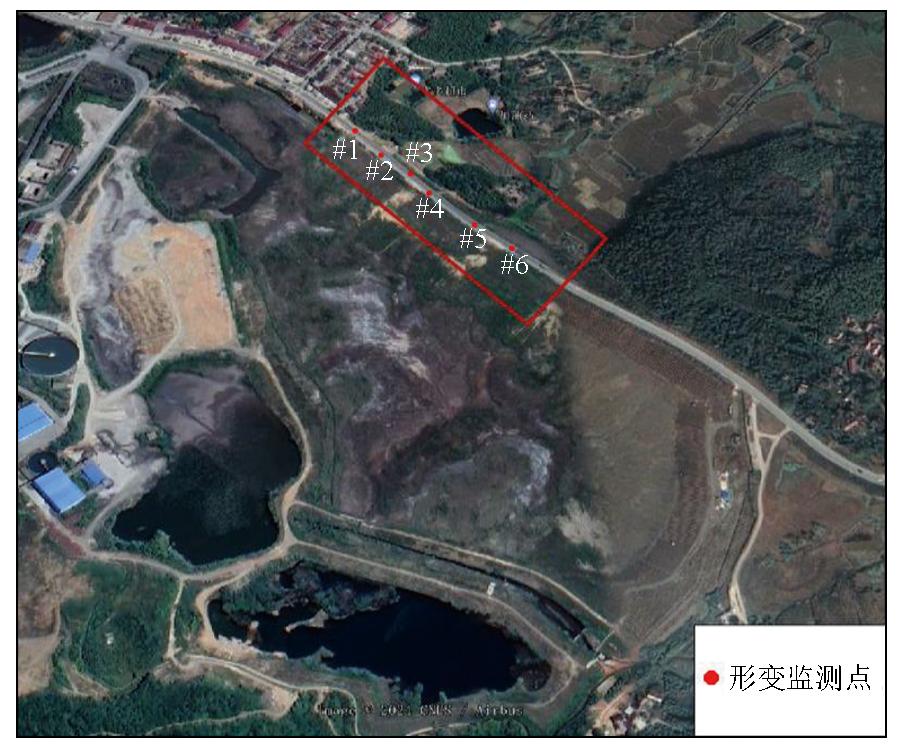
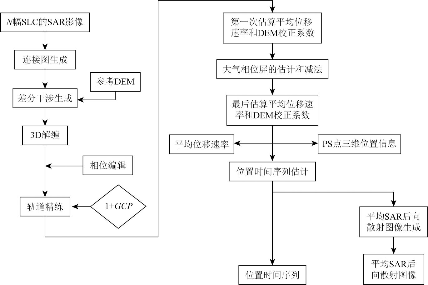
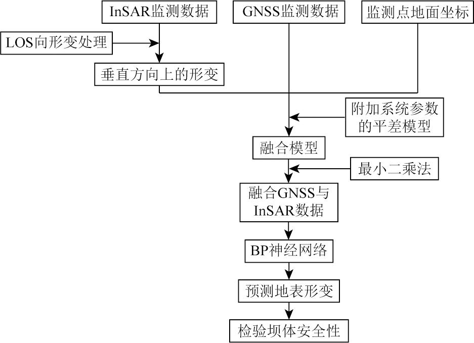
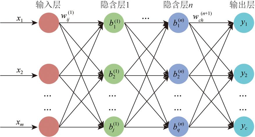
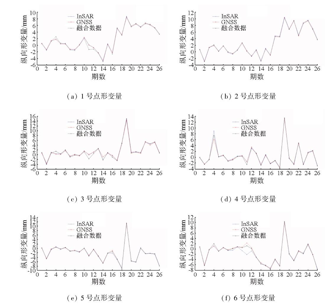
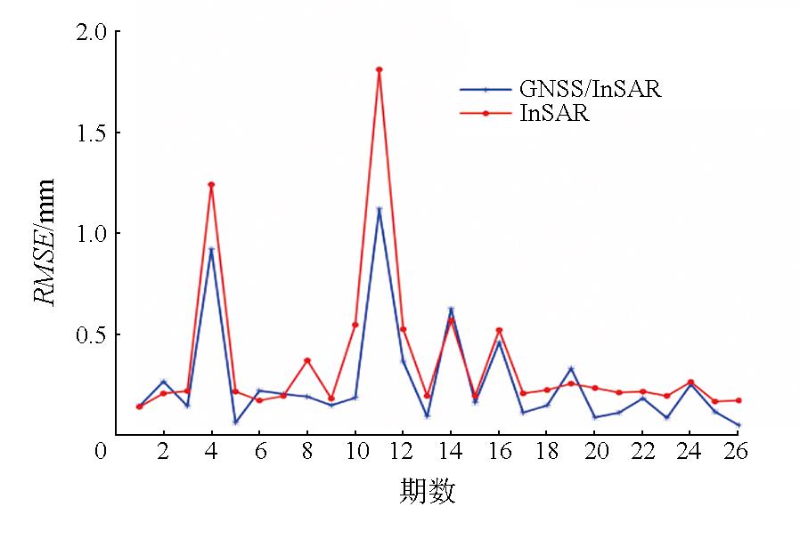
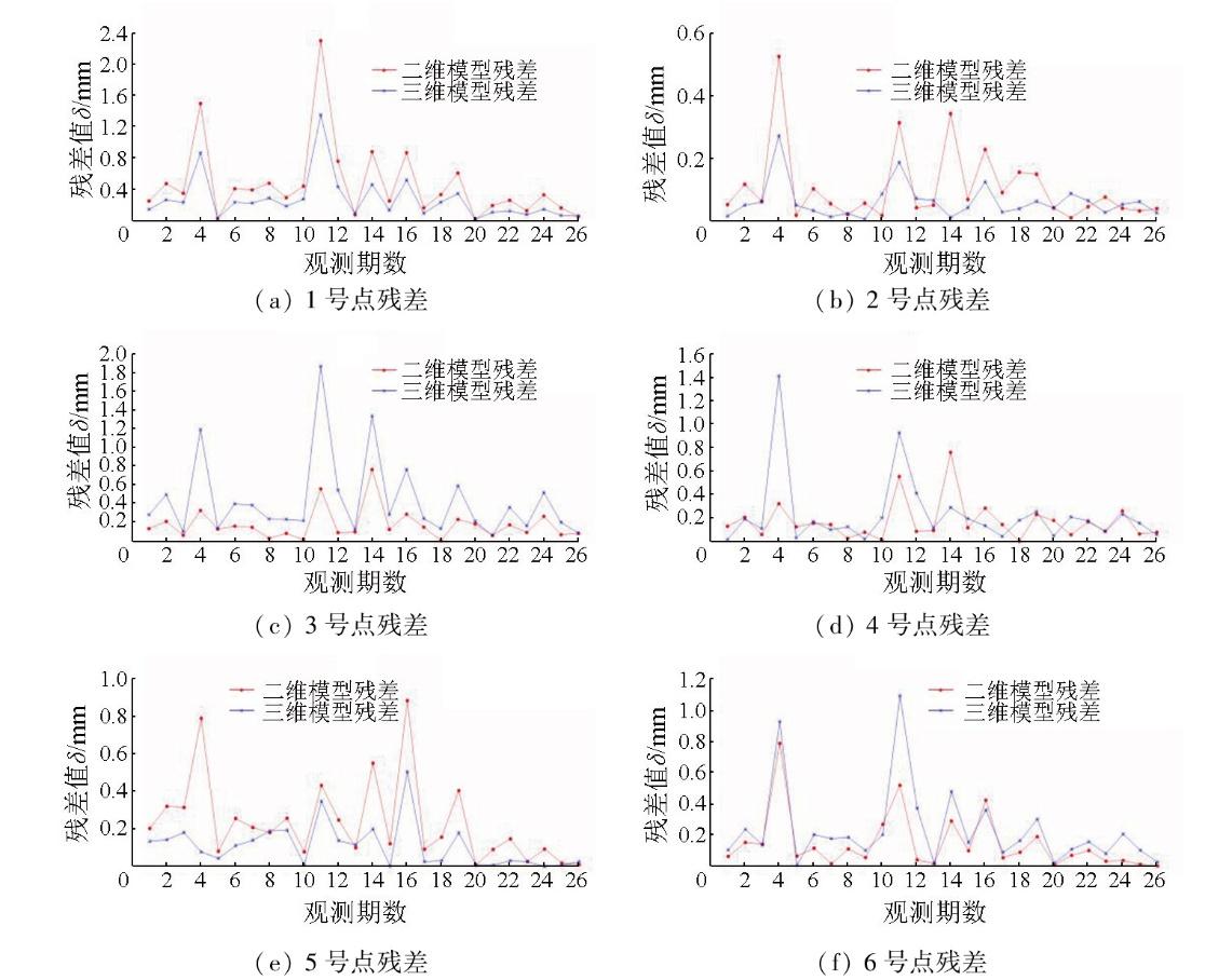
尾矿库坝体稳定性时序监测及预测一直都是我国矿山产业安全方面研究重点。该文利用InSAR与GNSS技术获取安徽省某尾矿库坝体表面6个特征监测点的26期纵向形变数据,通过建立附有限制参数的平差模型,以监测点的初始三维坐标作为多项式改正参数,对合成孔径雷达干涉测量技术(interferometric synthetic aperture Radar,InSAR)数据与全球导航卫星定位系统(global navigation satellite system,GNSS)数据进行融合以提高数据精度,并利用BP神经网络对监测点的形变数据进行时序预测,从而得到监测点的未来形变数据。实验结果表明,GNSS与InSAR数据融合后以均方根误差(root mean square error,RMSE)作为精度评定标准,计算并比较融合前、后每一期形变数据与形变真值的RMSE,得到融合后RMSE较融合前下降最多70.61%,平均下降25.91%。采用神经网络模型对融合后的1~22期InSAR数据反复训练,以23~26期InSAR形变数据作为测试集,最后输出各点23~26期数据。通过与GNSS数据计算各点网络输出值RMSE<1.5 mm。研究成果能够为尾矿库坝体时序稳定性监测及预测提供可靠技术支撑。
关键词: 尾矿库; SBASInSAR; 附有限制参数的平差模型; BP
吕林伟 , 王瑞 , 许林涛 , 黄诗乔 , 黄帅帅 , 林敏 , 贺一波 , 何倩 , 晏慧能 , 陈尚波 . 基于神经网络的InSAR/GNSS深度融合尾矿库坝体时序监测及预测研究[J]. 自然资源遥感, 2025 , 37(5) : 162 -171 . DOI: 10.6046/zrzyyg.2024271
The time-series monitoring and prediction of tailings dam stability have always been a major concern in China’s mine safety research. Focusing on a tailings dam in Anhui province,this study obtained 26 periods of longitudinal deformation data from six characteristic monitoring points on the dam surface,using InSAR and GNSS technologies. Based on the data,a least-squares adjustment model with restricted parameters was established. Combined with the initial three-dimensional coordinates of the monitoring points as polynomial correction parameters,the InSAR and GNSS data were fused to improve the data accuracy. Then,time-series prediction of deformation data was conducted for the monitoring points using the back propagation (BP) neural network,thus obtaining their future deformation data. Experiments were carried out to compute and compare the deformation data and corresponding root mean square error (RMSE) of each period before and after fusion,wherein the fused GNSS and InSAR data were evaluated with the root mean square error (RMSE) as the accuracy standard. The results showed that the post-fusion RMSE decreased by up to 70.61% and by at least 4.34% (average:25.91%),compared to pre-fusion data. Furthermore,the neural network model was used to repeatedly train the fused InSAR data from periods 1 to 22,with periods 23 to 26 serving as the test set,ultimately outputting the data of each point for periods 23 to 26. Compared to the GNSS data,the RMSE of the outputs were less than 1.5 mm. These results can provide reliable technical support for the time-series monitoring and prediction of tailings dam stability.
表1 观测点三维空间坐标数据Tab.1 3D spatial coordinate data of observation points |
| 观测点 | X | Y | Z |
|---|---|---|---|
| #1 | 4 695.661 | 5 138.075 | 30.438 |
| #2 | 4 667.625 | 5 166.371 | 30.377 |
| #3 | 4 639.355 | 5 194.903 | 30.446 |
| #4 | 4 611.383 | 5 223.137 | 30.502 |
| #5 | 4 583.200 | 5 251.577 | 30.466 |
| #6 | 4 554.937 | 5 280.115 | 30.271 |
表2 各点InSAR数据与GNSS融合后的数据Tab.2 Data after InSAR data and GNSS fusion at each point |
| 期数 | 形变量/mm | 期数 | 形变量/mm | ||||||||||
|---|---|---|---|---|---|---|---|---|---|---|---|---|---|
| #1 | #2 | #3 | #4 | #5 | #6 | #1 | #2 | #3 | #4 | #5 | #6 | ||
| 1 | 0.637 1 | 0.615 5 | 0.979 5 | -0.082 2 | 0.234 0 | 0.803 0 | 14 | -4.956 4 | -2.788 8 | -2.134 8 | -2.791 1 | -6.699 8 | -5.676 9 |
| 2 | -1.460 7 | -2.950 4 | -3.993 2 | -2.491 5 | -4.643 6 | -6.334 6 | 15 | 0.427 4 | 0.842 5 | 0.981 6 | 0.797 3 | -2.098 1 | -6.149 1 |
| 3 | 1.273 6 | 1.239 1 | 0.801 0 | -0.811 3 | -0.381 7 | -0.333 6 | 16 | -2.615 4 | -1.124 9 | -0.962 9 | -2.236 6 | -1.405 7 | -7.558 9 |
| 4 | 2.658 6 | 2.072 8 | 1.490 7 | 7.412 5 | 0.520 3 | 2.025 0 | 17 | 5.109 2 | 4.628 5 | -2.439 1 | -1.143 9 | -4.825 7 | -3.887 0 |
| 5 | 0.474 9 | 0.049 4 | 0.335 2 | 0.169 2 | -0.244 7 | -0.795 4 | 18 | 3.069 5 | 4.539 3 | 4.668 6 | -3.581 6 | -8.931 5 | -6.462 6 |
| 6 | 0.629 5 | 1.733 3 | 2.096 4 | 0.672 0 | 0.412 4 | 0.601 5 | 19 | 8.841 9 | 10.362 4 | 15.089 3 | 13.455 7 | 11.380 1 | 10.399 6 |
| 7 | -1.319 0 | -0.113 3 | -0.880 3 | -1.401 8 | -1.241 2 | -0.475 0 | 20 | 5.687 2 | 6.759 1 | 0.908 7 | -0.348 7 | -5.607 8 | -1.784 0 |
| 8 | -1.484 2 | -0.624 5 | -0.133 0 | -0.926 9 | -0.990 5 | 0.117 2 | 21 | 6.497 3 | 9.412 2 | 1.143 2 | -2.409 3 | -6.108 6 | -4.407 3 |
| 9 | 0.121 5 | 0.494 8 | -0.430 2 | 0.221 7 | -1.595 3 | 0.800 5 | 22 | 5.618 1 | 4.864 5 | 0.958 5 | 4.878 0 | 0.231 5 | -0.646 1 |
| 10 | 2.128 4 | 2.686 0 | 1.283 6 | 0.297 1 | 0.091 0 | 0.500 9 | 23 | 6.627 7 | 8.626 6 | 5.340 9 | -2.485 7 | -2.274 1 | -1.678 8 |
| 11 | -1.245 6 | 0.287 7 | -1.665 7 | -2.530 0 | -3.448 7 | 1.209 5 | 24 | 6.440 3 | 9.453 2 | 4.616 0 | 1.632 2 | -2.200 9 | 1.804 0 |
| 12 | -1.126 7 | -1.372 2 | 0.561 0 | 3.087 9 | -0.439 2 | 0.131 3 | 25 | 5.362 4 | 6.862 3 | 5.398 5 | 2.257 3 | -2.408 6 | -2.099 4 |
| 13 | -2.288 3 | 0.465 3 | 2.618 1 | 1.317 1 | -3.416 0 | -3.081 8 | 26 | 3.346 7 | 3.626 3 | 0.785 0 | -2.959 6 | -7.874 3 | -7.624 1 |
表3 网络预测输出值与融合值的RMSETab.3 RMSE of the network prediction output value and the fusion value (mm) |
| 点号 | #1 | #2 | #3 | #4 | #5 | #6 |
|---|---|---|---|---|---|---|
| RMSE | 0.610 5 | 0.962 5 | 1.290 4 | 0.648 8 | 0.764 1 | 1.199 8 |
表4 由神经网络预测的第27期监测点形变值Tab.4 Deformation value of the 27th monitoring point predicted by the neural network (mm) |
| 点号 | #1 | #2 | #3 | #4 | #5 | #6 |
|---|---|---|---|---|---|---|
| 神经网络输出第27期形变数据 | 3.503 5 | 7.264 9 | 4.717 8 | 3.492 5 | 2.992 9 | -13.474 3 |
| [1] |
李如仁, 孙加瑶. 融合SBAS-InSAR与GS-LSTM的尾矿库沉降监测与预测[J]. 金属矿山, 2023(1):102-109.
|
| [2] |
马东升. 基于GNSS形变监测技术的尾矿库安全在线监测系统在司家营北区尾矿库的应用[J]. 中国金属通报, 2019(11):140-141.
|
| [3] |
陈娅男. 基于时序InSAR尾矿坝(库区)监测及灾害识别[D]. 昆明: 昆明理工大学, 2020.
|
| [4] |
朱建军, 杨泽发, 李志伟. InSAR矿区地表三维形变监测与预计研究进展[J]. 测绘学报, 2019, 48(2):135-144.
|
| [5] |
许才军, 王华, 黄劲松. GPS与INSAR数据融合研究展望[J]. 武汉大学学报(信息科学版), 2003, 28(s1):58-61,78.
|
| [6] |
刘国林, 张连蓬, 成枢, 等. 合成孔径雷达干涉测量与全球定位系统数据融合监测矿区地表沉降的可行性分析[J]. 测绘通报, 2005(11):10-13.
|
| [7] |
曹海坤, 赵丽华, 张勤, 等. 利用附加系统误差参数的升降轨InSAR-GPS数据融合方法建立三维形变场[J]. 武汉大学学报(信息科学版), 2018, 43(9):1362-1368.
|
| [8] |
王洲. GNSS与InSAR地面形变监测深度融合[D]. 兰州: 兰州交通大学, 2021.
|
| [9] |
熊威, 孙志杰, 张必昌. 升降轨时序InSAR技术监测天津市地面沉降[J]. 地理空间信息, 2021, 19(12):45-49.
|
| [10] |
|
| [11] |
|
| [12] |
赵华伟, 周林, 谭明伦, 等. 基于光学遥感和SBAS-InSAR的川渝输电网滑坡隐患早期识别[J]. 自然资源遥感, 2023, 35(4):264-272 doi:10.6046/zrzyyg.2022321.
|
| [13] |
周定义, 左小清, 赵志芳, 等. 基于SBAS-InSAR和改进BP神经网络的城市地面沉降预测[J]. 地质通报, 2023, 42(10):1774-1783.
|
| [14] |
易邦进, 黄成, 傅涛, 等. 基于SBAS-InSAR 技术的中缅边境山区地质灾害隐患探测[J]. 自然资源遥感, 2023, 35(4):186-191.doi:10.6046/zrzyyg.2022261.
|
| [15] |
刘青利, 隋立芬. 附加系统参数的平差模型研究[J]. 测绘学院学报, 2004, 21(1):5-7,10.
|
| [16] |
魏飞, 谭志祥, 邓喀中. 附加系统参数平差在二维控制网平差中的应用[J]. 煤炭技术, 2017, 36(3):139-141.
|
| [17] |
陈映彬, 文逸彦, 董国祥, 等. 基于BP人工神经网络与遗传算法的航速优化[J]. 舰船科学技术, 2024, 46(1):82-87.
|
| [18] |
|
| [19] |
张焱飞, 李荣宗, 文逸彦, 等. 基于人工神经网络的实船航行主机能耗预估自学习模型[J]. 上海船舶运输科学研究所学报, 2019, 42(2):34-37.
|
| [20] |
王瑞. 开采沉陷监测多源数据融合技术及应用研究[D]. 徐州: 中国矿业大学, 2022.
|
/
| 〈 |
|
〉 |
