
基于多源遥感时序特征和卷积神经网络的露天矿区土地利用分类
|
刘 昊(2001-),男,硕士研究生,主要从事遥感智能解译方面的研究。Email: liuhao07515@163.com。 |
Copy editor: 陈昊旻
收稿日期: 2024-02-27
修回日期: 2024-10-16
网络出版日期: 2026-06-03
基金资助
自然资源要素耦合过程与效应重点实验室开放课题“多源数据融合的矿区精细用地分类与生态环境质量评价”(2022KFKTC001)
Land use classification of open-pit mining areas based on multi-source remote sensing time series features and convolutional neural networks
Received date: 2024-02-27
Revised date: 2024-10-16
Online published: 2026-06-03
刘昊 , 杜守航 , 邢江河 , 李军 , 高天琳 , 尹程弘 . 基于多源遥感时序特征和卷积神经网络的露天矿区土地利用分类[J]. 自然资源遥感, 2025 , 37(4) : 99 -107 . DOI: 10.6046/zrzyyg.2024080
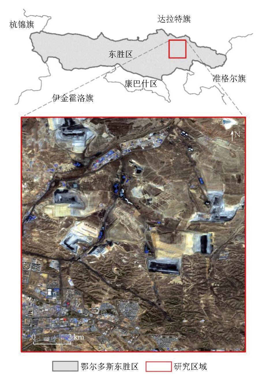
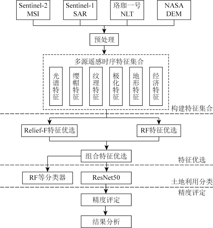
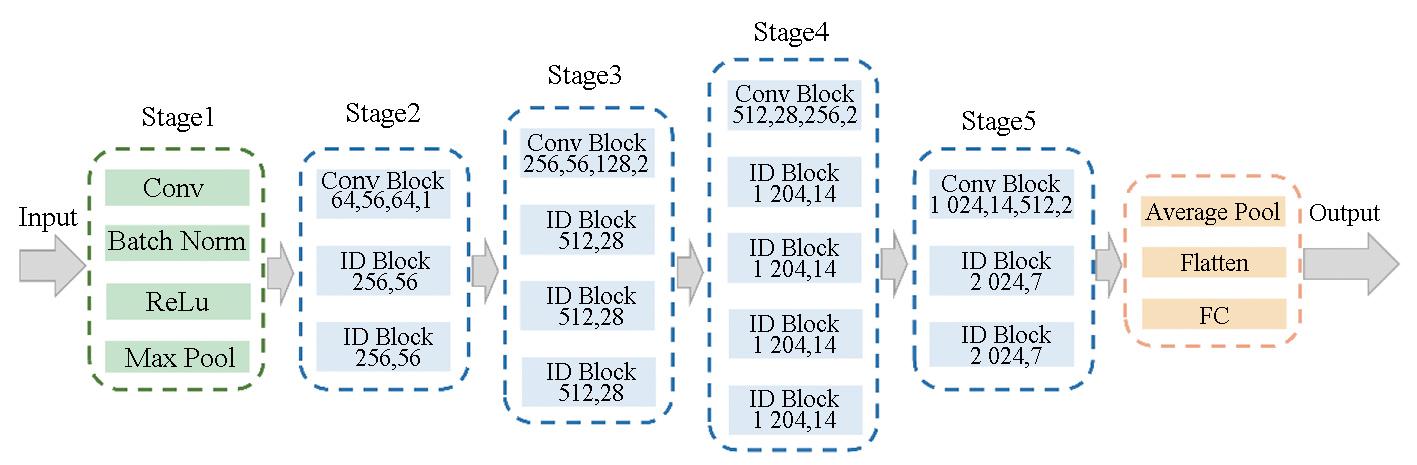
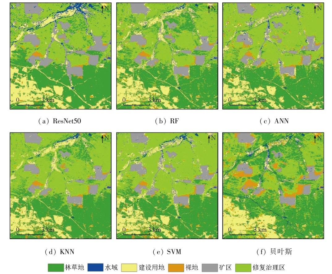
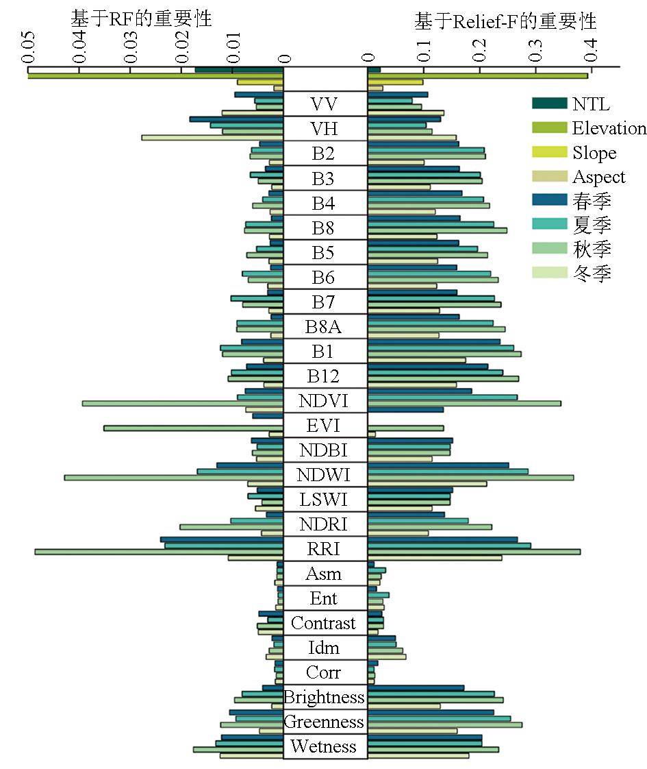
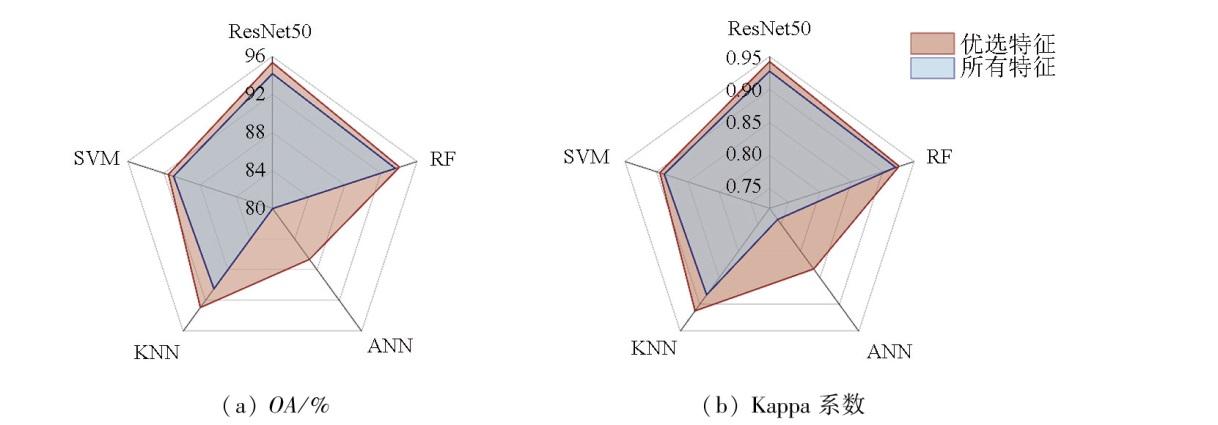
Resource development in mining areas alters land use patterns and causes ecological damage. This renders land use identification crucial to ecological restoration and management in mining areas. Although remote sensing imagery is widely used for land use classification, the use of a single data source has limitations in the classification for mining areas. Additionally, it is difficult for conventional machine learning algorithms to effectively perform the classification. To improve classification accuracy, this study investigated the eastern part of Dongsheng District, Ordos City as an example to conduct land use classification for mining areas using a convolutional neural network (CNN) combined with multi-source remote sensing data. First, a multi-source remote sensing time series feature set was developed using data from Sentinel-1/2, Luojia-1 01, and the NASA digital elevation model (DEM). Next, optimal features were selected using the Relief-F algorithm combined with a random forest algorithm. Finally, information on surface features was extracted using the ResNet50 CNN model. This facilitated land use classification in the mining area. The results show that the proposed method achieved an overall land use classification accuracy of 95.36% and a Kappa coefficient of 0.942 1, outperforming conventional methods such as the random forest approach. Furthermore, selecting optimal features using Relief-F combined with the random forest approach enhanced the classification accuracy of various classifiers. This study offers a methodological reference for land use classification of mining areas.
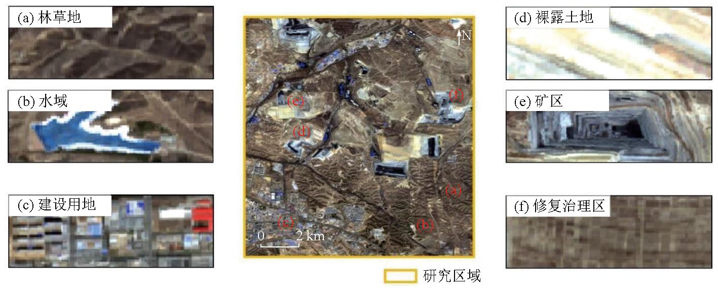
表1 分类方案、样本点及图像特征Tab.1 Classification scheme, sample points and image feature |
| 类别 | 定义 | 样本点/个 |
|---|---|---|
| 林草地 | 林地、草地等植被区域 | 600 |
| 水域 | 自然陆地水域、水利设施、积水塘 | 200 |
| 建设用地 | 城乡居民点及交通用地 | 670 |
| 裸露土地 | 地表覆盖为土壤或岩石的区域 | 200 |
| 矿区 | 矿坑及开采矿物堆积区域 | 600 |
| 修复治理区 | 停止开采后,进行生态修复的区域 | 600 |
表2 特征来源、类别和分辨率Tab.2 Source, category and resolution of features |
| 编码 | 数据源 | 类别 | 特征 | 分辨率/m |
|---|---|---|---|---|
| 1-17 | Sentinel-2 | 光谱 | blue; green; red; NIR; red edge 1-4; SWIR1-2; NDVI; EVI; NDWI; LSWI; NDBI; RRI; NDRI | 10/20 |
| 18-20 | Sentinel-2 | 缨帽 | Brightness; Greenness; Wetness | 10 |
| 21-25 | Sentinel-2 | 纹理 | Asm; Ent; Contrast; Idm; Corr | 10 |
| 26-27 | Sentinel-1 | 极化 | VV; VH; | 10 |
| 28-30 | NASA DEM | 地形 | Elevation; Slope; Aspect | 30 |
| 31 | 珞珈一号 | 经济 | NTL | 130 |
表4 特征优选结果Tab.4 Feature selection results |
| 类型 | 优选特征 |
|---|---|
| 经济 | NTL |
| 地形 | Elevation,Slope |
| 纹理 | 春季: Contrast; 秋季: Contrast; 冬季: Contrast |
| 缨帽 | 春季: Brightness,Greenness,Wetness |
| 夏季: Brightness,Greenness,Wetness | |
| 秋季: Brightness,Greenness,Wetness | |
| 冬季: Brightness,Greenness,Wetness | |
| 极化 | 春季: VV,VH; 夏季: VV,VH |
| 秋季: VV,VH; 冬季: VV,VH | |
| 光谱 | 春季: B2,B3,B4,B8,B5,B6,B7,B8A,B11,B12,NDVI,EVI,NDBI,NDWI,LSWI,NDRI,RRI |
| 夏季: B2,B3,B4,B8,B5,B6,B7,B8A,B11,B12,NDVI,NDBI,NDWI,LSWI,NDRI,RRI | |
| 秋季: B2,B3,B4,B8,B5,B6,B7,B8A,B11,B12,NDVI,EVI,NDBI,NDWI,LSWI,NDRI,RRI | |
| 冬季: B4,B8,B5,B6,B7,B8A,B11,B12,NDVI,NDBI,NDWI,LSWI,NDRI,RRI |
表5 综合特征优选的有效性Tab.5 Effectiveness of comprehensive feature selection |
| 特征 | OA/% | Kappa系数 |
|---|---|---|
| 所有特征 | 94.20 | 0.927 6 |
| RF | 94.97 | 0.937 1 |
| Relief-F | 95.10 | 0.939 0 |
| 综合优选 | 95.36 | 0.942 1 |
| [1] |
|
| [2] |
|
| [3] |
|
| [4] |
张伟, 吴艳民, 刘吉凯. Landsat系列影像支持下的凤阳县石英砂矿区土地利用动态监测[J]. 测绘通报, 2018(6):91-97.
|
| [5] |
|
| [6] |
|
| [7] |
王德军, 姜琦刚, 李远华, 等. 基于Sentinel-2A/B时序数据与随机森林算法的农耕区土地利用分类[J]. 国土资源遥感, 2020, 32(4):236-243.doi:10.6046/gtzyyg.2020.04.29.
|
| [8] |
|
| [9] |
|
| [10] |
|
| [11] |
|
| [12] |
|
| [13] |
|
| [14] |
胡云锋, 商令杰, 张千力, 等. 基于GEE平台的1990年以来北京市土地变化格局及驱动机制分析[J]. 遥感技术与应用, 2018, 33(4):573-583.
|
| [15] |
|
| [16] |
毛丽君, 李明诗. GEE环境下联合Sentinel主被动遥感数据的国家公园土地覆盖分类[J]. 武汉大学学报(信息科学版), 2023, 48(5):756-764.
|
| [17] |
陈彦四, 黄春林, 侯金亮, 等. 基于多时相Sentinel-2影像的黑河中游玉米种植面积提取研究[J]. 遥感技术与应用, 2021, 36(2):324-331.
|
| [18] |
|
| [19] |
|
| [20] |
|
| [21] |
|
| [22] |
吴宏安, 蒋建军, 张海龙, 等. 比值居民地指数在城镇信息提取中的应用[J]. 南京师大学报(自然科学版), 2006, 29(3):118-121.
|
| [23] |
张晓伦, 甘淑. 基于NDRI像元二分模型的石漠化信息提取研究[J]. 新技术新工艺, 2014(1):72-75.
|
| [24] |
霍轩琳, 牛振国, 张波, 等. 高寒湿地分类的遥感特征优选研究[J]. 遥感学报, 2023, 27(4):1045-1060.
|
| [25] |
刘吉超, 王锋. 基于Relief-F的半监督特征选择算法[J]. 郑州大学学报(理学版), 2021, 53(1):42-46,53.
|
| [26] |
|
| [27] |
|
| [28] |
张立亭, 夏文生, 罗亦泳, 等. 改进双重注意力机制结合ResNet50的遥感图像分类[J]. 测绘科学, 2023, 48(4):98-105.
|
| [29] |
|
| [30] |
|
/
| 〈 |
|
〉 |