
基于SBAS-InSAR技术的中老铁路沿线地表形变空间分布研究——以景洪段为例
|
靳婷婷(1999-),女,硕士,主要研究方向为雷达干涉测量。Email: 2323130106@ynnu.edu.cn。 |
Copy editor: 张仙
收稿日期: 2024-05-27
修回日期: 2024-08-26
网络出版日期: 2026-06-03
基金资助
云南省重大科技专项“面向云南自然资源生态环境监测及技术治理的关键技术研究”(202202AD080010)
云南师范大学研究生科研创新基金(YJSJJ25-B148)
Exploring the spatial distribution of surface deformations along the China-Laos railway based on SBAS-InSAR technology: Taking the Jinghong section as an example
Received date: 2024-05-27
Revised date: 2024-08-26
Online published: 2026-06-03
关键词: SBAS-InSAR; 地表形变; 中老铁路; 空间分布
靳婷婷 , 喜文飞 , 钱堂慧 , 郭峻杞 , 洪文玉 , 丁子天 , 桂富羽 . 基于SBAS-InSAR技术的中老铁路沿线地表形变空间分布研究——以景洪段为例[J]. 自然资源遥感, 2025 , 37(4) : 232 -240 . DOI: 10.6046/zrzyyg.2024186
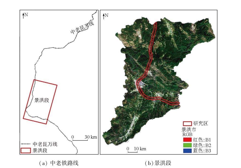
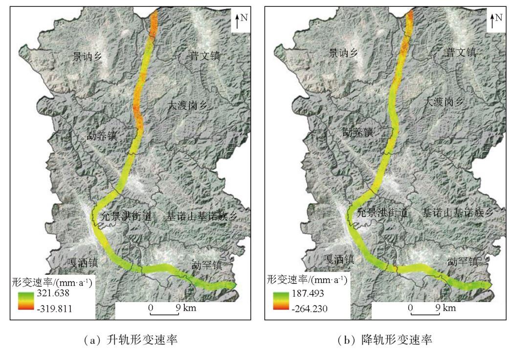
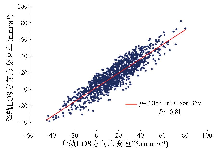
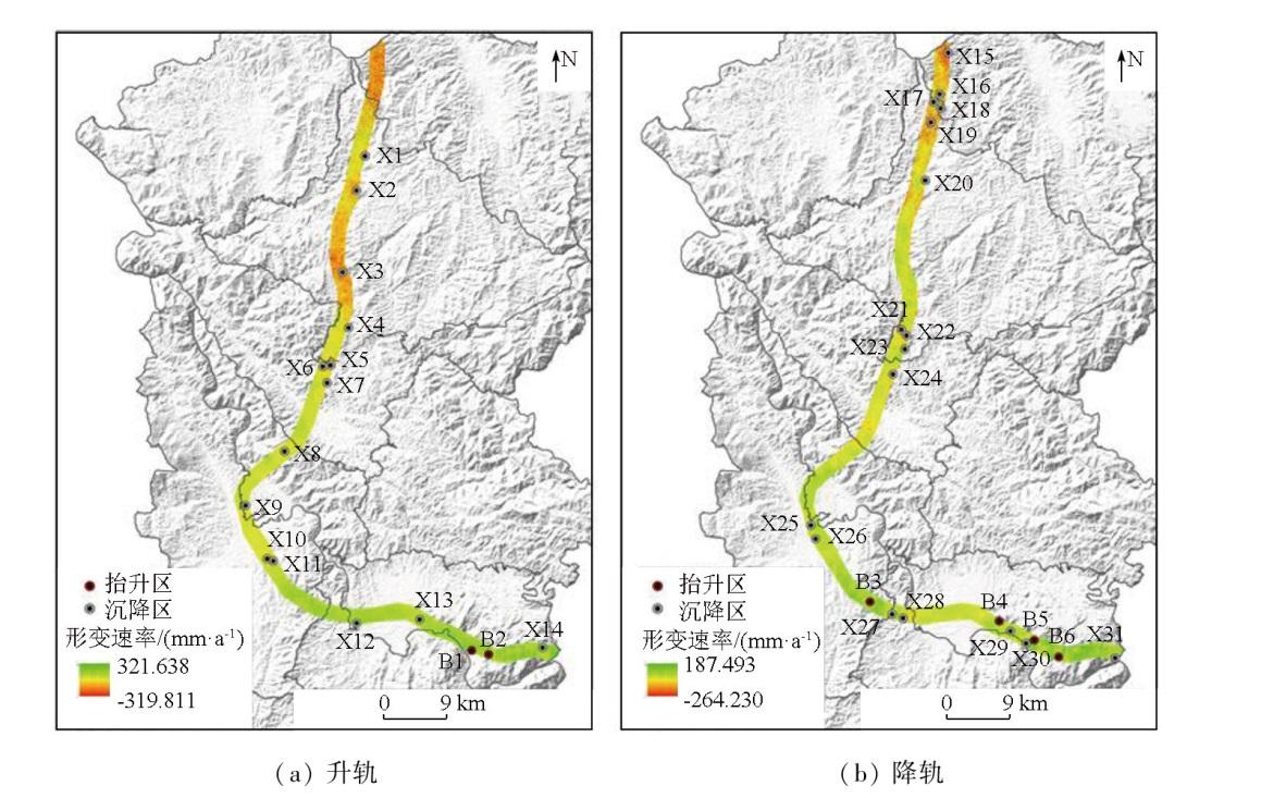
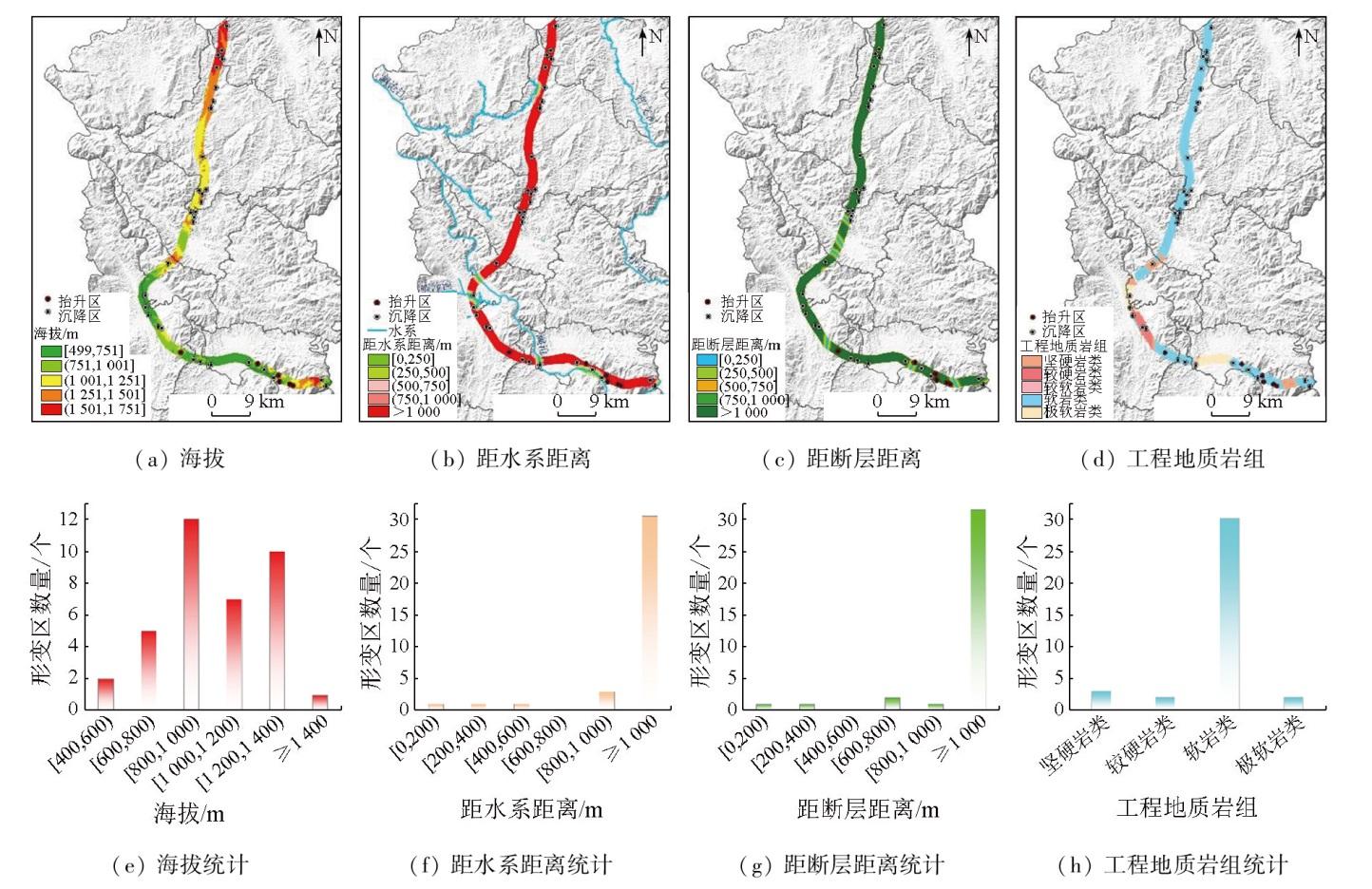
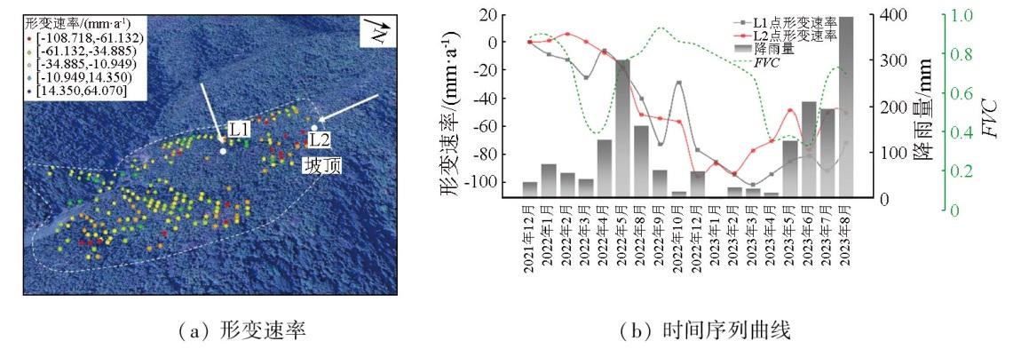
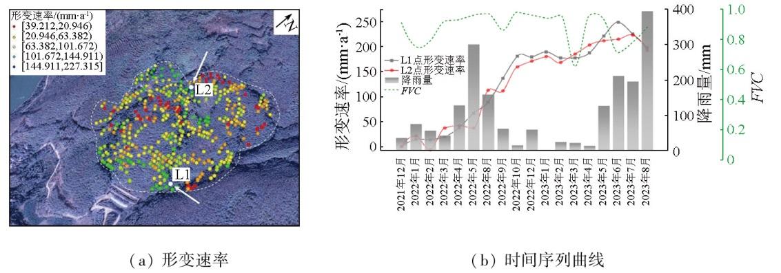
Surface deformations pose significant threats to the normal operation of railways. Investigating the spatial distribution of surface deformations along the China-Laos railway holds great significance for disaster prevention and mitigation. Based on 36 scenes of ascending orbit and 50 scenes of descending orbit images from Sentinel-1A satellite from December 2021 to August 2023, this study conducted deformation inversion using the small baseline subset interferometric synthetic aperture Radar (SBAS-InSAR) technique. Besides, this study conducted spatial distribution statistics and analysis of surface deformations along the Jinghong section of the China-Laos railway. The results indicate that the overall deformation along the railway exhibits a heterogeneous distribution, with multiple potential hazards in the northern mountainous area. Among the selected typical deformation zones, the maximum subsidence rate in the northern mountainous area reaches -108.718 mm/a, whereas the southern plain area shows significant uplift with a rate of 227.315 mm/a. Along the railway, the surface deformation rates in the line of sight (LOS) direction ranged from -319.811 mm/a to 321.638 mm/a. Obvious subsidence occurred in Puwen Town and Dadugang Township. Conversely, minor subsidence was observed in urban areas like Mengyang town, Yunjinghong subdistrict, and Gasa town, with pronounced uplifts in the southeastern part of Menghan town. Along the railway, deformations in mountainous areas were primarily concentrated at elevations ranging from 800 m to 1400 m, with soft rocks prevailing in these deformed areas. InSAR-based analysis of the spatial distribution of the surface deformations along the railway is of significant value for the safe operation of the railway.
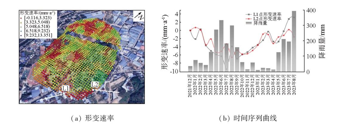
表1 形变区统计Tab.1 Statistics of the deformation areas |
| 因子 | 分级 | 形变区数量/个 | 占比/% |
|---|---|---|---|
| 海拔 | [400,600) m | 2 | 5.4 |
| [600,800) m | 5 | 13.5 | |
| [800,1 000) m | 12 | 32.4 | |
| [1 000,1 200) m | 7 | 18.9 | |
| [1 200,1 400) m | 10 | 27.0 | |
| ≥1 400 m | 1 | 2.7 | |
| 距水系距离 | <1 000 m | 6 | 16.2 |
| ≥1 000 m | 31 | 83.8 | |
| 距断层距离 | <1 000 m | 5 | 13.5 |
| ≥1 000 m | 32 | 86.5 | |
| 工程地质 岩组 | 坚硬岩类 | 3 | 5.4 |
| 较硬岩类 | 2 | 8.1 | |
| 软岩类 | 30 | 81.1 | |
| 极软岩类 | 2 | 5.4 |
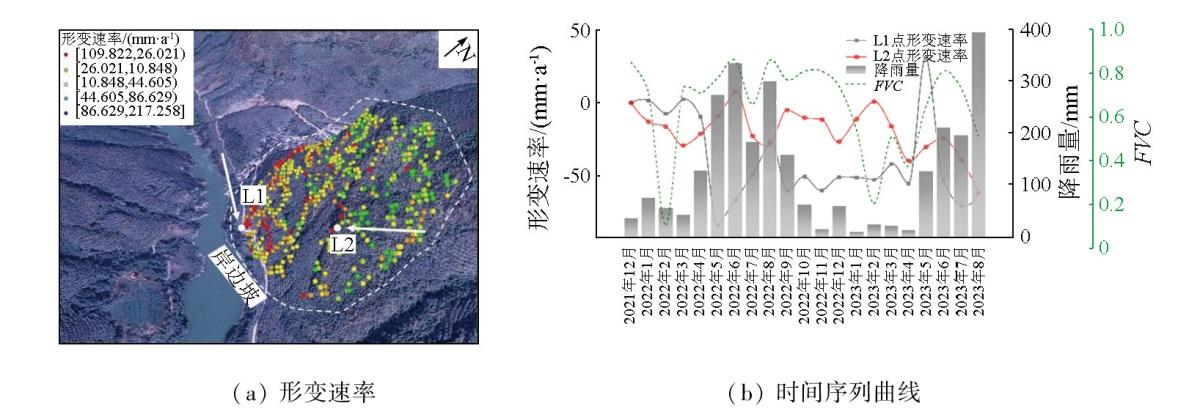
表2 典型区形变特征Tab.2 Description of deformation characteristics |
| 形变区 | 位置 | 地理环境 | 形变特点 |
|---|---|---|---|
| X7 | 勐养镇 | 海拔1 250 m以上,岩体为硅质碎屑岩沉积岩 | 整体呈现沉降趋势 |
| B1 | 勐罕镇 | 海拔800 m以下,属于软岩类岩体,土质疏松 | 整体以抬升为主 |
| X25 | 嘎洒镇 | 左侧存在耕地与绿植区,右侧多为不透水面,下部主要为软岩 | 整体形变程度较小,呈现上下波动状态 |
| X30 | 勐罕镇 | 属于构造剥蚀中山地貌,节理裂隙发育,岩石破碎,发育多组纵向节理 | 整体以沉降为主,2023年4—5月形变急剧 |
| [1] |
刘凯斯, 宫辉力, 陈蓓蓓. 基于InSAR数据的北京地铁6号线地面沉降监测分析[J]. 地球信息科学学报, 2018, 20(1):128-137.
|
| [2] |
罗三明, 杜凯夫, 万文妮, 等. 利用PSInSAR方法反演大时空尺度地表沉降速率[J]. 武汉大学学报(信息科学版), 2014, 39(9):1128-1134.
|
| [3] |
赵国堂, 赵如锋, 刘俊飞. 高速铁路路基工后沉降变形源、变形传递与轨道不平顺控制方法[J]. 铁道学报, 2020, 42(12):127-134.
|
| [4] |
刘春雷, 张媛静, 陆晨明, 等. 基于时序InSAR的九龙江河口地区地面沉降时空演变规律及成因分析[J]. 应用海洋学学报, 2024, 43(1):116-125.
|
| [5] |
范军, 左小清, 李涛, 等. PS-InSAR和SBAS-InSAR技术对昆明主城区地面沉降监测的对比分析[J]. 测绘工程, 2018, 27(6):50-58.
|
| [6] |
朱军桃, 兰荣添, 李海林, 等. 基于时序InSAR的厦门市地面沉降监测与分析[J]. 海洋测绘, 2023, 43(5):56-60,66.
|
| [7] |
曹景峰, 刘洪铖. 基于Quickbird影像的水库库岸滑坡遥感解译研究[J]. 吉林水利, 2017(12):4-6,10.
|
| [8] |
朱怡飞, 姚鑫, 姚磊华, 等. 基于InSAR和光学遥感的贵州鬃岭采煤滑坡识别与危险性评价[J]. 地质力学学报, 2022, 28(2):268-280.
|
| [9] |
卫达宁, 王世杰. 基于时序InSAR技术的西安地铁沿线沉降监测及预测分析[J]. 地球物理学进展, 2024, 39(2):498-509.
|
| [10] |
王艳, 廖明生, 李德仁, 等. 利用长时间序列相干目标获取地面沉降场[J]. 地球物理学报, 2007, 50(2):598-604.
|
| [11] |
葛鹏飞, 刘辉, 陈蜜, 等. 时序InSAR监测京雄城际铁路河北段地面沉降[J]. 测绘通报, 2022(7):64-70.
|
| [12] |
陈宝山, 张立峰, 何毅, 等. 兰新高速铁路军马场-民乐段地表形变监测及成因[J]. 兰州大学学报(自然科学版), 2022, 58(2):222-228,238.
|
| [13] |
|
| [14] |
张学东, 葛大庆, 肖斌, 等. 多轨道集成PS-InSAR监测高速公路沿线地面沉降研究——以京沪高速公路(北京—河北)为例[J]. 测绘通报, 2014(10):67-69,104.
|
| [15] |
|
| [16] |
|
| [17] |
陈有东, 何毅, 张立峰, 等. 联合升降轨Sentinel-1A的地表形变监测技术研究[J]. 海洋测绘, 2020, 40(4):59-64.
|
| [18] |
王文辉, 何毅, 张立峰, 等. 基于PS-InSAR和GeoDetector的兰州主城区地表变形监测与驱动力分析[J]. 兰州大学学报(自然科学版), 2021, 57(3):382-388,394.
|
| [19] |
张诗茄, 蒋建军, 缪亚敏, 等. 基于SBAS技术的岷江流域潜在滑坡识别[J]. 山地学报, 2018, 36(1):91-97.
|
| [20] |
李凌婧, 姚鑫, 张永双, 等. 基于SBAS-InSAR技术的中巴公路(公格尔—墓士塔格段)地质体缓慢变形识别研究[J]. 工程地质学报, 2014, 22(5):921-927.
|
| [21] |
|
| [22] |
何清, 魏路, 肖永红. 基于SBAS-InSAR技术的安徽亳州市地面沉降时空分布特征与影响因素分析[J]. 中国地质灾害与防治学报, 2023, 34(5):81-90.
|
| [23] |
|
/
| 〈 |
|
〉 |