
FY-3D卫星微波资料反演湖南地区强降水
|
王陶然(2001-),女,学士,助理工程师,主要从事大气探测与卫星遥感研究。Email: 1079144967@qq.com。 |
Copy editor: 陈昊旻
收稿日期: 2024-05-27
修回日期: 2024-09-27
网络出版日期: 2026-06-03
基金资助
国家自然科学基金联合基金项目“风云卫星产品对数值预报同化应用支撑的关键技术及应用效益评估研究”(U2242212)
Inversion of heavy precipitation in Hunan based on FY-3D/MWRI data
Received date: 2024-05-27
Revised date: 2024-09-27
Online published: 2026-06-03
关键词: FY-3D/MWRI; PCT-SI算法; 强降水; 降水率反演
王陶然 , 吴莹 , 马靖雯 , 黄媛媛 , 付琪嘉 . FY-3D卫星微波资料反演湖南地区强降水[J]. 自然资源遥感, 2025 , 37(4) : 212 -219 . DOI: 10.6046/zrzyyg.2024179
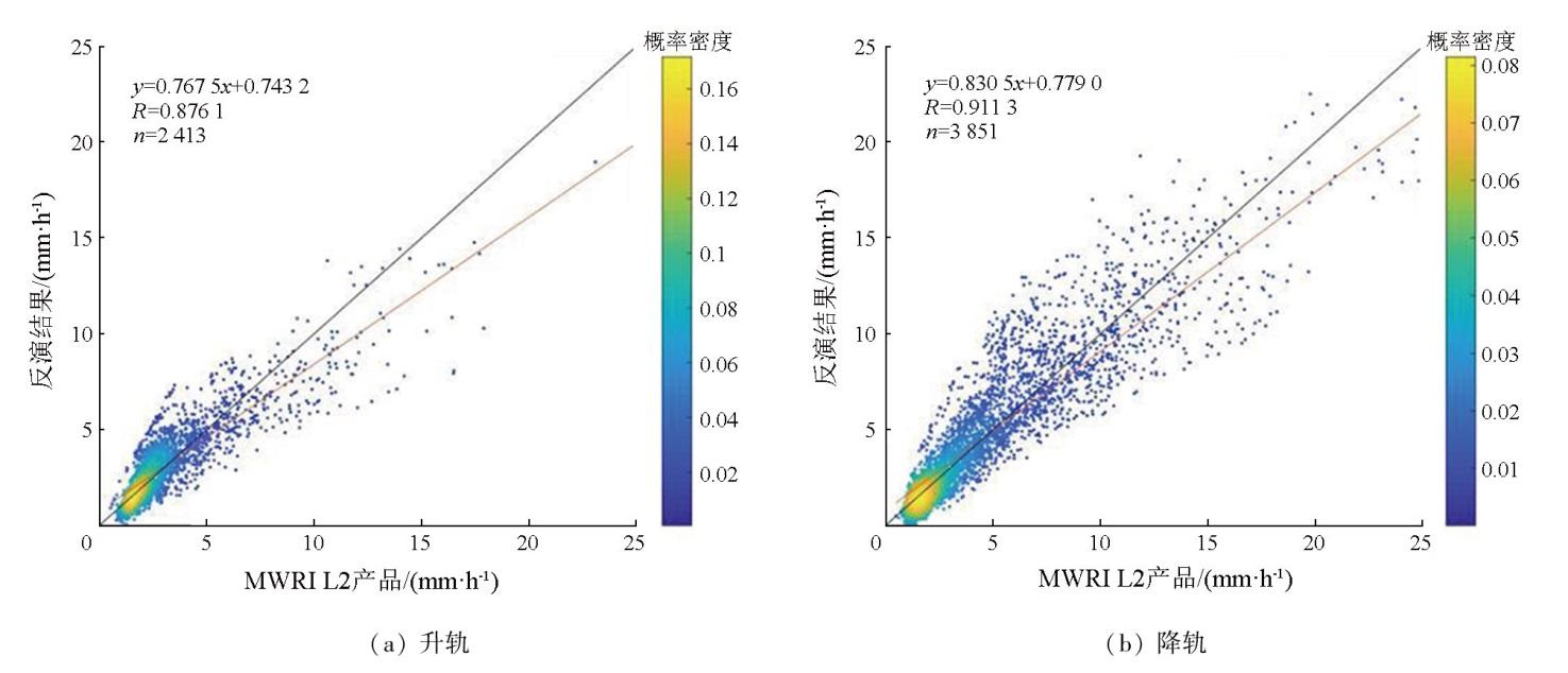
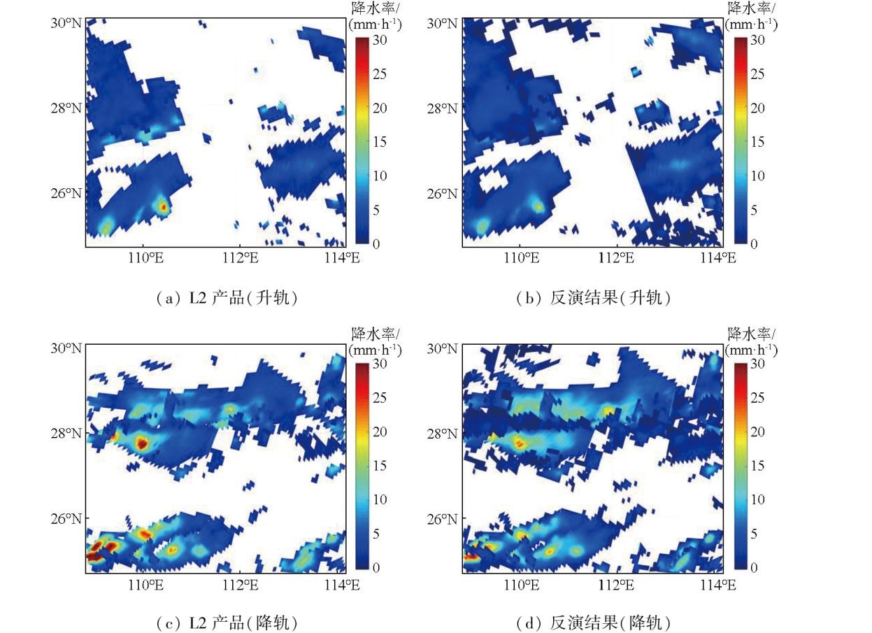
Using level-1 (L1) brightness temperature data from the Microwave Radiation Imager (MWRI) on board Fengyun-3D (FY-3D) satellite and the corresponding Level-2 (L2) precipitation products, this study established a precipitation rate inversion model for land surface heavy precipitation in Hunan Province based the polarization corrected temperature (PCT) and scatter index (SI). The proposed model was validated using individual examples. The results indicate that the precipitation rates retrieved from the L1 brightness temperature data of the FY-3D satellite were generally consistent with the results obtained from the L2 precipitation products. Compared to actual data, the retrieved precipitation rates were slightly higher in low precipitation areas but smaller in centers of high precipitation areas. The ascending orbit-based inversion model exhibited a correlation coefficient, mean absolute error (MAE), and root mean square error (RMSE) of 0.876 1, 0.771 1, and 1.151 4 mm/h, respectively. Conversely, the descending orbit-based inversion model presented a correlation coefficient, MAE, and RMSE of 0.911 3, 1.130 4, and 1.832 2 mm/h, respectively. The inversion results showed a larger precipitation distribution range than that of L2 products. Compared to the measurements at ground meteorological stations, the inversion model demonstrated higher accuracy than L2 products. This study successfully determined the distribution of land surface heavy precipitation in Hunan through inversion. The results of this study can provide a reference for investigating the relationship between microwave brightness temperature and precipitation and estimating land surface heavy precipitation.
表1 模型精度评价指标Tab.1 Model precision evaluation indicators |
| 个例 | 数据 量/个 | R | MAE/ (mm·h-1) | RMSE/ (mm·h-1) |
|---|---|---|---|---|
| 2022年6月1—10日升轨 | 241 3 | 0.876 1 | 0.771 1 | 1.151 4 |
| 2022年6月1—10日降轨 | 385 1 | 0.911 3 | 1.130 4 | 1.832 2 |
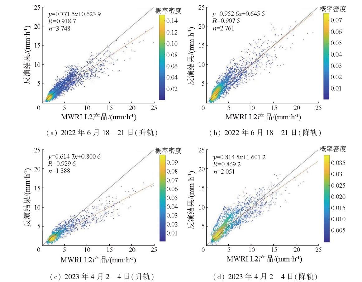
| 2022年6月18—21日升轨 | 374 8 | 0.918 7 | 0.822 4 | 1.299 5 |
| 2022年6月18—21日降轨 | 276 1 | 0.907 5 | 1.086 7 | 1.476 1 |
| 2023年4月2—4日升轨 | 138 8 | 0.929 6 | 1.319 7 | 2.117 7 |
| 2023年4月2—4日降轨 | 205 1 | 0.869 2 | 1.461 3 | 1.906 4 |
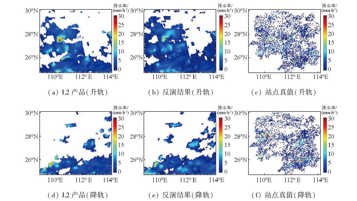
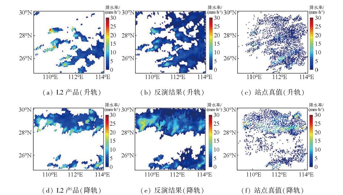
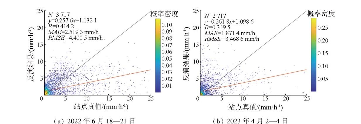
图4 2022年6月18—21日反演降水率与FY-3D卫星L2产品、站点数据对比Fig.4 Comparison of retrieved rain rate with FY-3D satellite L2 products and station data from 18 to 21, June, 2022 |
图5 2023年4月2—4日反演降水率与FY-3D卫星L2产品、站点数据对比Fig.5 Comparison of retrieved rain rate with FY-3D satellite L2 products and station data from 2 to 4, April, 2023 |
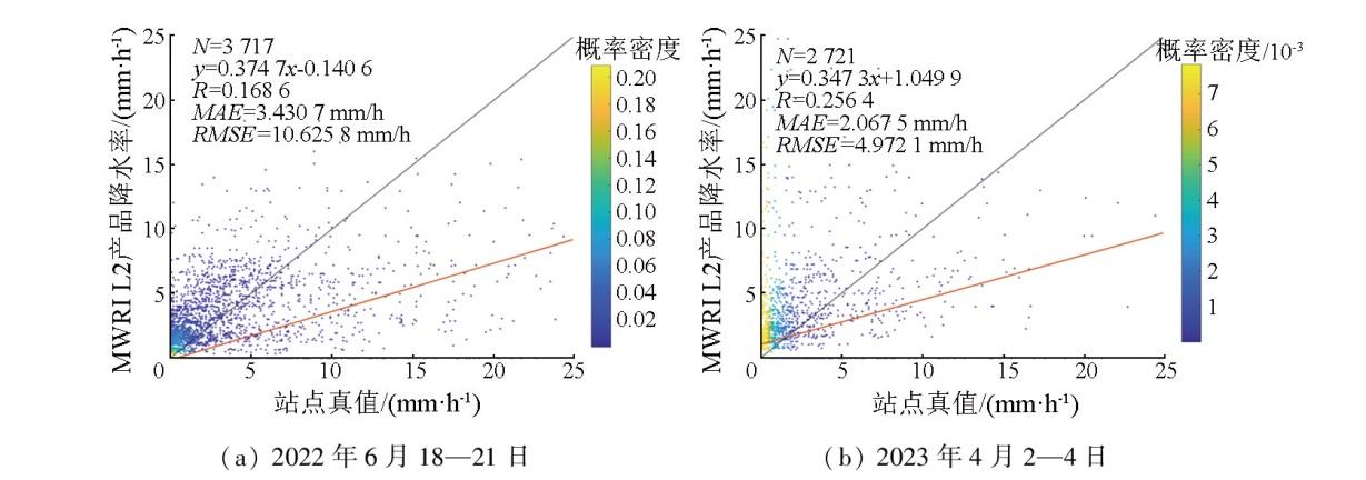
图6 2个降水个例L2产品与站点真值拟合概率密度散点图(升轨)Fig.6 The L2 products of two precipitation cases fitted to the scatter plot of the station data (ascending orbits) |
| [1] |
李莹, 赵珊珊. 2001—2020年中国洪涝灾害损失与致灾危险性研究[J]. 气候变化研究进展, 2022, 18(2):154-165.
|
| [2] |
马铮, 王国复, 张颖娴. 1961—2019年中国区域连续性暴雨过程的危险性区划[J]. 气候变化研究进展, 2022, 18(2):142-153.
|
| [3] |
|
| [4] |
|
| [5] |
杜方洲, 石玉立, 盛夏. 基于深度学习的TRMM降水产品降尺度研究——以中国东北地区为例[J]. 国土资源遥感, 2020, 32(4):145-153.doi:10.6046/gtzyyg.2020.04.19.
|
| [6] |
|
| [7] |
|
| [8] |
何会中, 崔哲虎, 程明虎, 等. TRMM卫星及其数据产品应用[J]. 气象科技, 2004, 32(1):13-18.
|
| [9] |
唐国强, 万玮, 曾子悦, 等. 全球降水测量(GPM)计划及其最新进展综述[J]. 遥感技术与应用, 2015, 30(4) :607-615.
|
| [10] |
谷松岩, 张鹏, 陈林, 等. 中国首颗降水测量卫星(风云三号G星)的探测能力概述与展望[J]. 暴雨灾害, 42(5):489-498.
|
| [11] |
|
| [12] |
|
| [13] |
|
| [14] |
|
| [15] |
|
| [16] |
|
| [17] |
|
| [18] |
|
| [19] |
|
| [20] |
李万彪, 陈勇, 朱元竞, 等. 利用热带降雨测量卫星的微波成像仪观测资料反演陆地降水[J]. 气象学报, 2001, 59(5):591-601.
|
| [21] |
李世伟, 赖格英, 盛盈盈, 等. PCT-SI综合指数法反演陆面雨强[J]. 气象与环境科学, 2015, 38(2):102-107.
|
| [22] |
闵爱荣, 游然, 卢乃锰, 等. TRMM卫星微波成像仪资料的陆面降水反演[J]. 热带气象学报, 2008, 24(3):265-272.
|
| [23] |
邓欣柔, 吴莹. 基于GPM探测资料的台风降水水平结构分析[J]. 地球物理学进展, 2022, 37(5):1799-1806.
|
| [24] |
闵爱荣, 张翠荣, 王晓芳. 基于微波成像仪资料反演陆面降水[J]. 气象科技, 2008, 36(4):495-498.
|
/
| 〈 |
|
〉 |