
基于不透水面与夜间灯光的城市建成区时空演变分析
|
牟凤云(1979-),女,博士,研究方向为国土资源遥感、智慧城市建设、3S技术集成与应用方面研究。Email: mfysd@cqjtu.edu.cn。 |
Copy editor: 李瑜
收稿日期: 2024-03-08
修回日期: 2024-06-25
网络出版日期: 2026-06-03
基金资助
教育部人文社会科学研究规划基金项目“居民出行视角下智慧交通抗灾韧性及提升策略研究”(24YJAZH107)
重庆市教育委员会科学技术研究计划重点项目“居民出行视角下山地城市公路-轨道交通网络智慧协同抗洪涝灾害韧性优化方法研究”(KJZD-K202300707)
重庆交通大学研究生科研创新项目“城市绿色发展背景下成渝城市群碳储量与生态系统服务价值时空演变分析”(2024S0158)
重庆市研究生导师团队建设项目(JDDSTD2022002)
Spatiotemporal evolution analysis of urban built-up areas based on impervious surface and nighttime light
Received date: 2024-03-08
Revised date: 2024-06-25
Online published: 2026-06-03
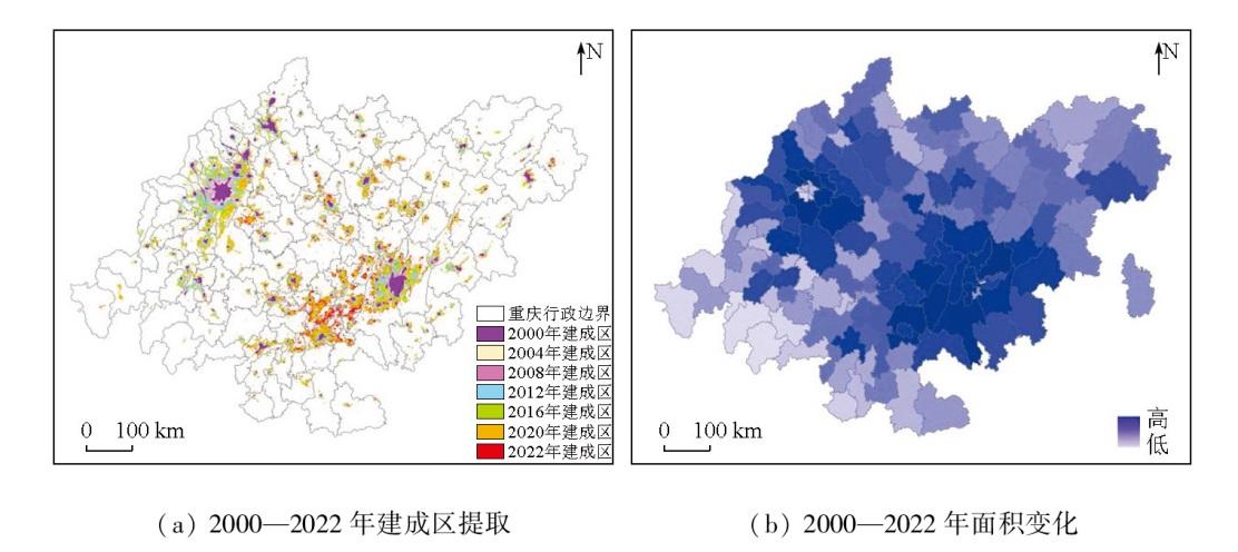
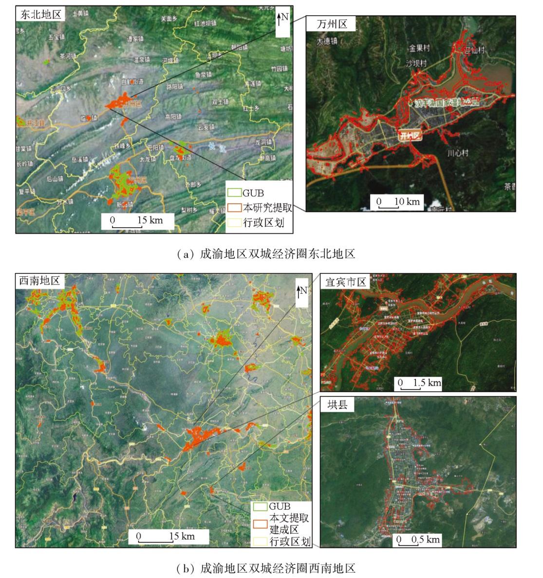
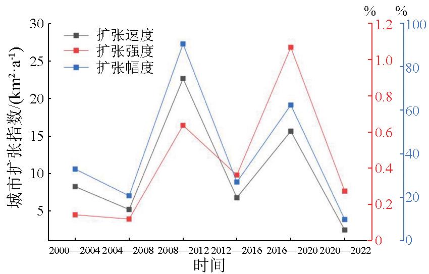
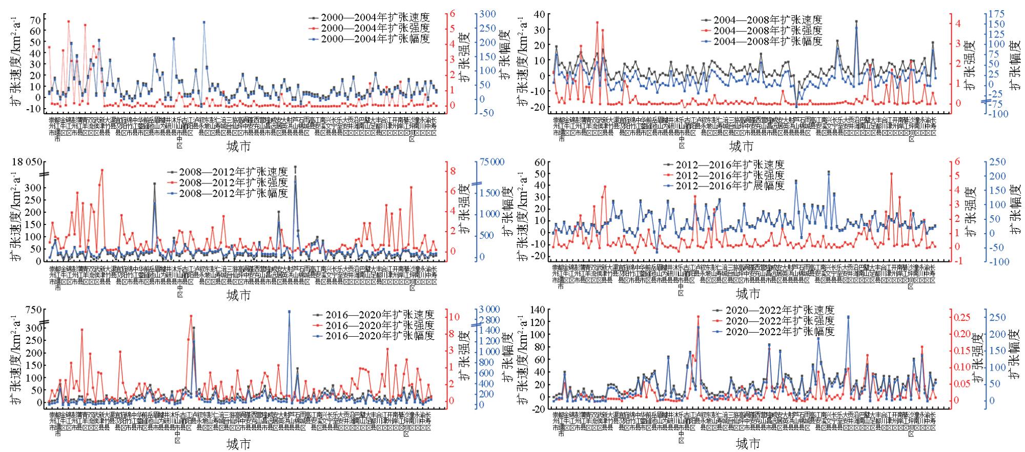
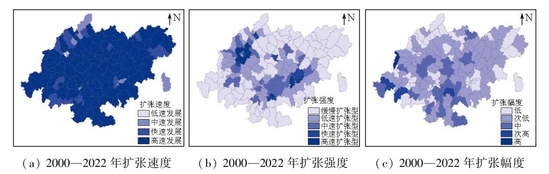
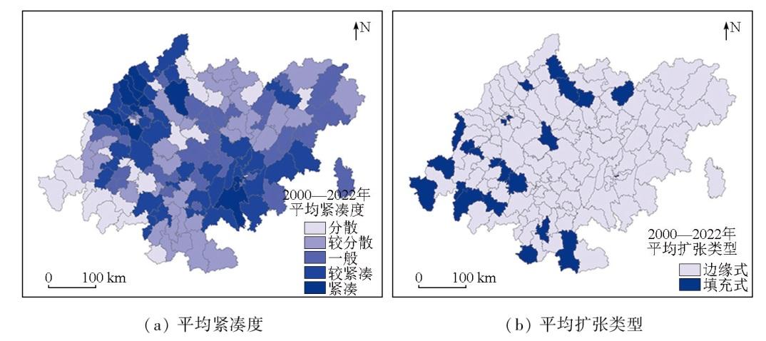
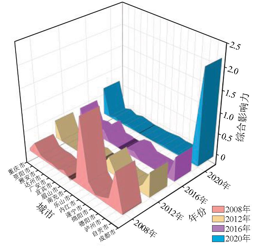
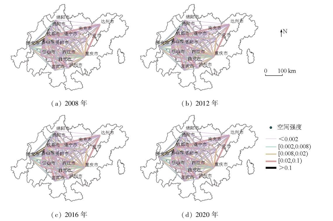
明晰城市扩张与空间变化特征,是优化城市空间结构、抑制城市用地无序扩张的前提。该研究以成渝地区双城经济圈为研究区,结合多源数据融合方法提取2000—2020年城市建成区; 从城市扩张特征、空间变化和城市间空间强度等方面对整体与县域2个尺度进行城市扩张时空演化分析。研究结果表明: ①将不透水面纳入多源数据融合能够提高建成区提取精度,总体分类精度98%,平均Kappa系数为0.75; ②2000—2020年城市扩张经历了低速-中速、高速-低速的变化过程,扩张类型主要是边缘式,空间紧凑度下降; ③成渝地区双城经济圈城市间空间强度最大为成都市与重庆市,城市空间形态表现为“双中心-两翼”格局,以成都市、重庆市为中心带动周边城市发展的作用凸显。研究结果揭示了成渝地区双城经济圈城市发展规律与空间变化特征,有助于土地利用与国土空间格局合理优化,促进城乡协调发展。
牟凤云 , 朱诗柔 , 左丽君 . 基于不透水面与夜间灯光的城市建成区时空演变分析[J]. 自然资源遥感, 2025 , 37(4) : 108 -117 . DOI: 10.6046/zrzyyg.2024087
Understanding the characteristics of urban expansion and corresponding spatial changes serves as a prerequisite for optimizing urban spatial structure and resisting disorderly urban land expansion. This study focuses on the Chengdu-Chongqing economic circle. Using multi-source data fusion, this study extracted information on urban built-up areas from 2000 to 2020. From the aspects of urban expansion characteristics, spatial changes, and intercity spatial interaction intensity, this study analyzed the spatiotemporal evolution during urban expansion at both the regional and county scales. The results indicate that incorporating impervious surface information into multi-source data fusion improved the information extraction accuracy of built-up areas, achieving an overall classification accuracy of 98% and an average Kappa coefficient of 0.75. Urban expansion from 2000 to 2020 transitioned from low to medium-high speed and then to low speed. The dominant expansion type was edge expansion, accompanied by decreased spatial compactness. Within the Chengdu-Chongqing economic circle, the strongest spatial interaction intensity occurred between Chengdu and Chongqing. The urban spatial pattern exhibited a “dual cores with two wings” pattern, highlighting the pivotal role of Chengdu and Chongqing in driving the development of surrounding cities. These findings reveal the urban development patterns and spatial change characteristics within the Chengdu-Chongqing economic circle. They will facilitate the rational optimization of land use and territorial spatial patterns, promoting coordinated urban-rural development.
表1 数据来源Tab.1 Data sources |
| 数据名称 | 格式 | 分辨率/m | 来源 |
|---|---|---|---|
| 不透水面数据 | 栅格 | 30 | 武汉大学遥感院遥感信息处理研究所黄昕教授团队[15]和宫鹏教授研究团队[16] |
| 夜间灯光数据 | 栅格 | 1 000 | 国防卫星气象计划[17] |
| NDVI | 栅格 | 1 000 | https://search.-earthdata.nasa.gov/search |
| 参考建成区 | 矢量 | - | GUB数据集[18] |
| 统计数据 | 矢量 | - | 统计年鉴 |
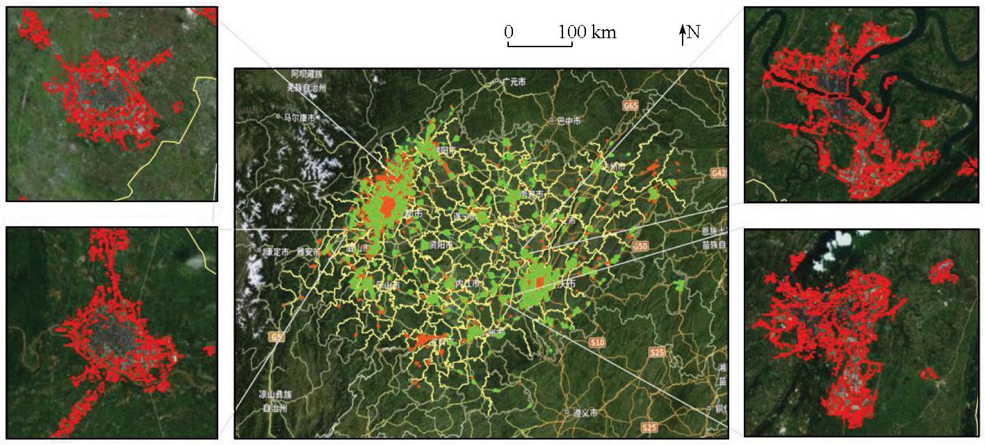
图1 成渝地区双城经济圈建成区2000—2022年空间扩张演变Fig.1 Spatial expansion evolution of the built-up area of Shuangcheng Economic Circle in Chengdu-Chongqing region from 2000 to 2022 |
| [1] |
张扬, 郑凤娇, 刘艳芳, 等. 基于POI与不透水表面指数的城市建成区提取[J]. 地理科学, 2022, 42(3):506-514.
|
| [2] |
|
| [3] |
省委、省政府印发《美丽四川建设战略规划纲要(2022—2035年)》- 四川省人民政府网站[EB/OL].[2024-01-01]. https://www.sc.gov.cn/10462/10464/10797/2022/8/29/493ddce2b-17f47fb9a2dd951abe0cb96.shtml.
The Provincial Party Committee and the provincial government issued the Outline of the Strategic Plan for the Construction of Beautiful Sichuan (2022-2035) - Sichuan Provincial People’s Government Website [EB/OL].[2024-01-01]. https://www.sc.gov.cn/10462/10464/10797/2022/8/29/493ddce2b-17f47fb9a2dd951abe0cb96.shtml.
|
| [4] |
重庆市人民政府关于印发《重庆市自然资源保护和利用“十四五”规划(2021—2025年)》的通知_重庆市人民政府网[EB/OL].[2024-01-01]. https://www.cq.gov.cn/zwgk/zfxxgkml/szfwj/xzgfxwj/szf/202201/t20220124_10360585.html.
Notice of Chongqing Municipal People’s Government on Issuing the 14th Five-Year Plan for the Protection and Utilization of Natural Resources of Chongqing (2021-2025).[2024-01-01]. https://www.cq.gov.cn/zwgk/zfxxgkml/szfwj/xzgfxwj/szf/202201/t20220124_10360585.html.
|
| [5] |
陈星星. 基于夜间灯光数据的武汉市城镇用地扩张识别与空间分布特征研究[J]. 西南师范大学学报(自然科学版), 2019, 44(1):70-78.
|
| [6] |
王敏, 李景保, 梁莉莉, 等. 基于夜间灯光数据的长沙市城市建成区提取结果对比分析[J]. 湖南师范大学自然科学学报, 2021, 44(4):45-52.
|
| [7] |
|
| [8] |
刘清云, 范俊甫, 陈政, 等. 夜间灯光遥感数据一致性校正下成渝城市群扩张分析[J]. 测绘科学, 2022, 47(6):99-108.
|
| [9] |
唐霞, 汤军, 李外宾, 等. 珞珈一号融合多源数据的建成区提取[J]. 遥感信息, 2023, 38(1):78-87.
|
| [10] |
尹旭, 魏慧, 李裕瑞. 基于不透水面的中国县城建成区识别与时空演变研究[J]. 地理研究, 2023, 42(6):1492-1505.
|
| [11] |
李广东, 戚伟. 中国建设用地扩张对景观格局演化的影响[J]. 地理学报, 2019, 74(12):2572-2591.
|
| [12] |
张亚萍, 张平, 孙丹峰, 等. 成渝城市群城市建设用地扩张格局及规模体系分析[J]. 测绘通报, 2020(7):103-107.
|
| [13] |
王亚楠, 苏明明, 王玉萍. 黄河流域城市扩张时空特征与区域差异——基于资源型城市与非资源型城市的对比[J]. 中国农业资源与区划, 2024, 45(6):223-233.
|
| [14] |
林钦贤, 林以恒, 真诗泳, 等. 建设用地扩张规律及其与道路网络的空间自相关分析——以福州市为例[J]. 科学技术与工程, 2023, 23(7):3001-3010.
|
| [15] |
|
| [16] |
|
| [17] |
|
| [18] |
|
| [19] |
许泽宁, 高晓路. 基于电子地图兴趣点的城市建成区边界识别方法[J]. 地理学报, 2016, 71(6):928-939.
|
| [20] |
郑洪晗, 桂志鹏, 栗法, 等. 夜间灯光数据和兴趣点数据结合的建成区提取方法[J]. 地理与地理信息科学, 2019, 35(2):25-32.
|
| [21] |
马歆, 和舒敏, 黄婷婷, 等. 城市用地扩张的时空格局特征及驱动因素分析——以中原城市群为例[J]. 生态经济, 2020, 36(3):105-111,167.
|
| [22] |
张娜, 张会霞, 李艾琴. 基于夜间灯光影像的太原市城市扩张特征及驱动力分析[J]. 测绘通报, 2022(11):79-83,105.
|
| [23] |
胡苗苗, 闫庆武, 李建辉. 基于DMSP/OLS和NPP/VIIRS夜光影像的中原城市群城市扩张的时空演变及驱动力分析[J]. 自然资源遥感, 2024(1):189-199.doi:10.6046/zrzyyg.2022410.
|
| [24] |
俞艳, 童艳, 胡珊珊, 等. 武汉城市圈城市空间相互作用时空演变分析[J]. 长江流域资源与环境, 2017, 26(11):1784-1794.
|
| [25] |
赵东卉, 刘勇, 刘秀华. 基于引力模型的多中心城市地价空间结构分析——以重庆市为例[J]. 西南大学学报(自然科学版), 2017, 39(7):130-135.
|
| [26] |
李春, 王金柱, 刘勇, 等. 成渝地区双城经济圈的城市扩张时空演变特征[J]. 现代城市研究, 2023(11):34-41,50.
|
| [27] |
刘小波, 王海力, 刘颖, 等. 成渝城市群中心城市空间扩展特征及驱动机制[J]. 重庆师范大学学报(自然科学版), 2024, 41(3):121-132.
|
/
| 〈 |
|
〉 |