
遥感主流教学科研软件在复杂矿山场景土地利用分类中的对比研究
|
张成业(1991-),男,博士,副教授、博导,主要从事矿区生态遥感监测等研究。Email: czhang@cumtb.edu.cn。 |
Office editor: 陈昊旻
收稿日期: 2023-12-20
修回日期: 2024-02-29
网络出版日期: 2026-06-03
基金资助
国家自然科学基金项目“露天煤矿区植被扰动过程遥感提取方法与全国分区时空规律挖掘”(42371347)
教育部产学合作协同育人项目“面向PIE首套实践教材的遥感数字图像处理体验式课程建设与共享”(202101162010)
Comparative study of popular remote sensing teaching and research software for land use classification in a complex mine scene
Received date: 2023-12-20
Revised date: 2024-02-29
Online published: 2026-06-03
张成业 , 李梦圆 , 邢江河 , 邱宇航 . 遥感主流教学科研软件在复杂矿山场景土地利用分类中的对比研究[J]. 自然资源遥感, 2025 , 37(3) : 9 -16 . DOI: 10.6046/zrzyyg.2023394
The performance of remote sensing image processing software directly influences the effectiveness and efficiency of teaching and research activities conducted by related workers. Focusing on land use classification in a complex mine scene, this study comparatively investigated the performance of popular remote sensing software including Pixel Information Expert (PIE), Environment for Visualizing Images (ENVI), ERDAS IMAGINE (ERDAS), and eCognition Developer (eCognition), and the self-developed deep learning algorithm. The results show that ENVI yielded the highest overall accuracy (OA) and Kappa coefficient but the lowest classification efficiency in conventional pixel-oriented classification. In contrast, ERDAS exhibited the highest operational efficiency while maintaining relatively high accuracy. eCognition achieved the optimal OA and Kappa coefficient and relatively high operational efficiency in conventional object-oriented classification. The deep convolutional neural network algorithm demonstrated superior accuracy over the classification results of conventional methods. Overall, this study quantitatively revealed the performance of various software on different strategies and methods, providing a scientific basis for related workers to choose appropriate image processing software and improve teaching effect and research efficiency.
表1 不同土地利用类型的样本数量Tab.1 Number of samples for different land use types(个) |
| 土地利用类型 | 训练集样本 | 测试集样本 | 总计 |
|---|---|---|---|
| 露天采场 | 331 | 116 | 447 |
| 排土场 | 218 | 108 | 326 |
| 复垦区 | 240 | 107 | 347 |
| 建筑 | 200 | 120 | 320 |
| 植被 | 344 | 175 | 519 |
| 裸地 | 201 | 102 | 303 |
| 总计 | 1 534 | 728 | 2 262 |
表2 面向像元分类的对比实验Tab.2 Comparative experiments on pixel-oriented classification |
| 面向像元 分类方法 | PIE- Basic | PIE- Engine AI | ENVI | ERDAS | eCognition |
|---|---|---|---|---|---|
| 最小距离法 | √ | × | √ | √ | × |
| 最大似然法 | √ | × | √ | √ | × |
| 支持向量机法 | √ | × | √ | √ | × |
| Attention_UNet | × | √ | × | × | × |
表3 面向对象分类的对比实验Tab.3 Comparative experiments on object-oriented classification |
| 面向对象 分类方法 | PIE-SIAS | ENVI | ERDAS | eCognition | Python+ PyCharm |
|---|---|---|---|---|---|
| 最小距离法 | √ | √ | × | √ | × |
| 最大似然法 | √ | × | × | √ | × |
| 支持向量机法 | √ | √ | × | √ | × |
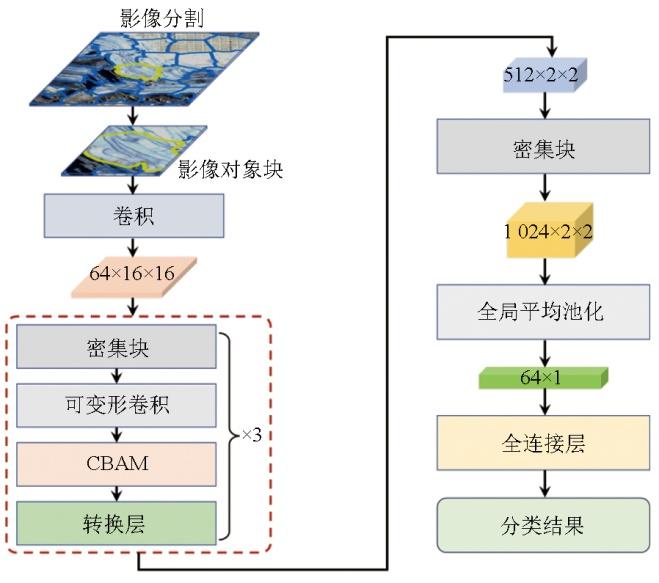
| ODCC | × | × | × | × | √ |
表4 不同方法参数设置Tab.4 Parameter settings for different methods |
| 处理方法 | 参数设置 |
|---|---|
| 最小距离法 | — |
| 最大似然法 | — |
| 支持向量机法 | 核函数: Radial Basis Function;惩罚系数: 20 |
| 深度卷积神经网络法 | 学习率: 0.000 1;迭代次数: 300;批次大小: 16;优化器:随机梯度下降 |
| 面向对象分类前处理 | 多尺度分割,分割尺度: 50;形状因子权重: 0.3;紧致度权重: 0.5 |
表5 面向像元分类的精度和运行时间对比Tab.5 Comparison of accuracy and runtime for pixel-oriented classification |
| 分类方法 | 软件 | OA/% | Kappa | 时间/s |
|---|---|---|---|---|
| 最小距离法 | PIE-Basic | 63.09 | 0.551 | 12 |
| ENVI | 67.19 | 0.601 | 51 | |
| ERDAS | 61.99 | 0.539 | 9 | |
| 最大似然法 | PIE-Basic | 70.03 | 0.632 | 47 |
| ENVI | 69.24 | 0.622 | 64 | |
| ERDAS | 67.08 | 0.596 | 15 | |
| 支持向量机法 | PIE-Basic | 67.67 | 0.607 | 68 |
| ENVI | 73.34 | 0.673 | 162 | |
| ERDAS | 71.14 | 0.647 | 36 | |
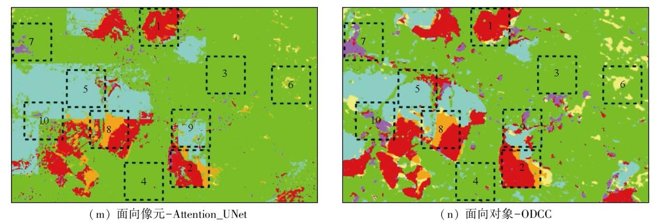
| Attention_UNet | PIE-Engine AI | 85.65 | 0.825 | — |
表6 面向对象分类的精度和运行时间对比Tab.6 Comparison of accuracy and runtime for object-oriented classification |
| 分类方法 | 软件 | OA/% | Kappa | 分割时间/s | 分类时间/s | 总时间/s |
|---|---|---|---|---|---|---|
| 最小距离法 | PIE-SIAS | 72.60 | 0.664 | 53 | 9 | 62 |
| ENVI | 73.66 | 0.679 | 96 | 22 | 118 | |
| eCognition | 75.87 | 0.706 | 89 | 4 | 93 | |
| 最大似然法 | PIE-SIAS | 74.29 | 0.686 | 53 | 38 | 91 |
| eCognition | 76.66 | 0.716 | 89 | 4 | 93 | |
| 支持向量机法 | PIE-SIAS | 73.50 | 0.677 | 53 | 56 | 109 |
| ENVI | 75.39 | 0.700 | 96 | 211 | 307 | |
| eCognition | 78.39 | 0.737 | 89 | 5 | 94 | |
| ODCC | Python+Pycharm | 93.95 | 0.940 | — | — | — |
| [1] |
刘东升, 廖通逵, 孙焕英, 等. 中国遥感软件研制进展与发展方向——以像素专家PIE为例[J]. 中国图象图形学报, 2021, 26(5):1169-1178.
|
| [2] |
|
| [3] |
闫琰, 董秀兰, 李燕. 基于ENVI的遥感图像监督分类方法比较研究[J]. 北京测绘, 2011, 25(3):14-16.
|
| [4] |
|
| [5] |
郝容, 屈鸿钧, 文学虎. eCognition(易康)软件在地理国情普查地表覆盖解译中的应用[J]. 测绘通报, 2014(4):134-135.
|
| [6] |
张成业, 李军, 赵恒谦, 等. PIE系列遥感软件在测绘类专业体验式教学中的应用[J]. 北京测绘, 2023, 37(9):1320-1325.
|
| [7] |
张成业, 李飞跃, 李军, 等. 基于DeepLabv3+与GF-2高分辨率影像的露天煤矿区土地利用分类[J]. 煤田地质与勘探, 2022, 50(6):94-103.
|
| [8] |
张成业, 邢江河, 李军, 等. 基于U-Net网络和GF-6影像的尾矿库空间范围识别[J]. 自然资源遥感, 2021, 33(4):252-257.doi:10.6046/zrzyyg.2021017.
|
| [9] |
|
| [10] |
陈蕊, 张继超. 基于eCognition的遥感图像面向对象分类方法研究[J]. 测绘与空间地理信息, 2020, 43(2):91-95.
|
| [11] |
王海芹, 杨燕, 汪生燕. 国外四大遥感软件影像分类过程及效果比较[J]. 地理空间信息, 2009, 7(5):153-155.
|
| [12] |
陈理, 张仙, 李伟, 等. 基于分层次多尺度分割的缅甸达贡山镍矿矿区信息提取与动态变化监测[J]. 自然资源遥感, 2024, 36(4):55-61.doi:10.6046/zrzyyg.2023182.
|
| [13] |
邵亚琴, 王佳佳, 银玉霞. 基于ENVI软件对忻州窑矿土地类型识别及精度评价[J]. 内蒙古科技大学学报, 2022, 41(1):66-75.
|
| [14] |
郄晨龙, 卞正富, 杨德军, 等. 鄂尔多斯煤田高强度井工煤矿开采对土壤物理性质的扰动[J]. 煤炭学报, 2015, 40(6):1448-1456.
|
| [15] |
|
| [16] |
|
| [17] |
|
| [18] |
|
| [19] |
|
| [20] |
|
| [21] |
|
| [22] |
|
| [23] |
|
| [24] |
|
/
| 〈 |
|
〉 |