
“三查”体系在高植被山区地质灾害隐患识别与监测中的应用——以四川省乐山市为例
|
周胜森(1997-),男,博士研究生,主要从事地质灾害早期识别与监测研究。Email: zhoushengsen@stu.cdut.edu.cn。 |
Office editor: 李瑜
收稿日期: 2024-01-10
修回日期: 2024-06-11
网络出版日期: 2026-06-03
基金资助
国家重点研发计划“重大崩滑灾害危险源识别指标体系研究”(2021YFC3000401)
四川省重点研发项目“山区重大地质灾害智能识别与动态风险评价关键技术研究”(2023YFS0435)
四川省自然资源厅 “四川省地质灾害隐患遥感识别监测(2022年)和高分遥感应用服务项目”(N5100012022001470)
Application of the space-air-ground investigation system in the identification and monitoring of geohazards in highly vegetation-covered mountain areas: A case study of Leshan City, Sichuan Province
Received date: 2024-01-10
Revised date: 2024-06-11
Online published: 2026-06-03
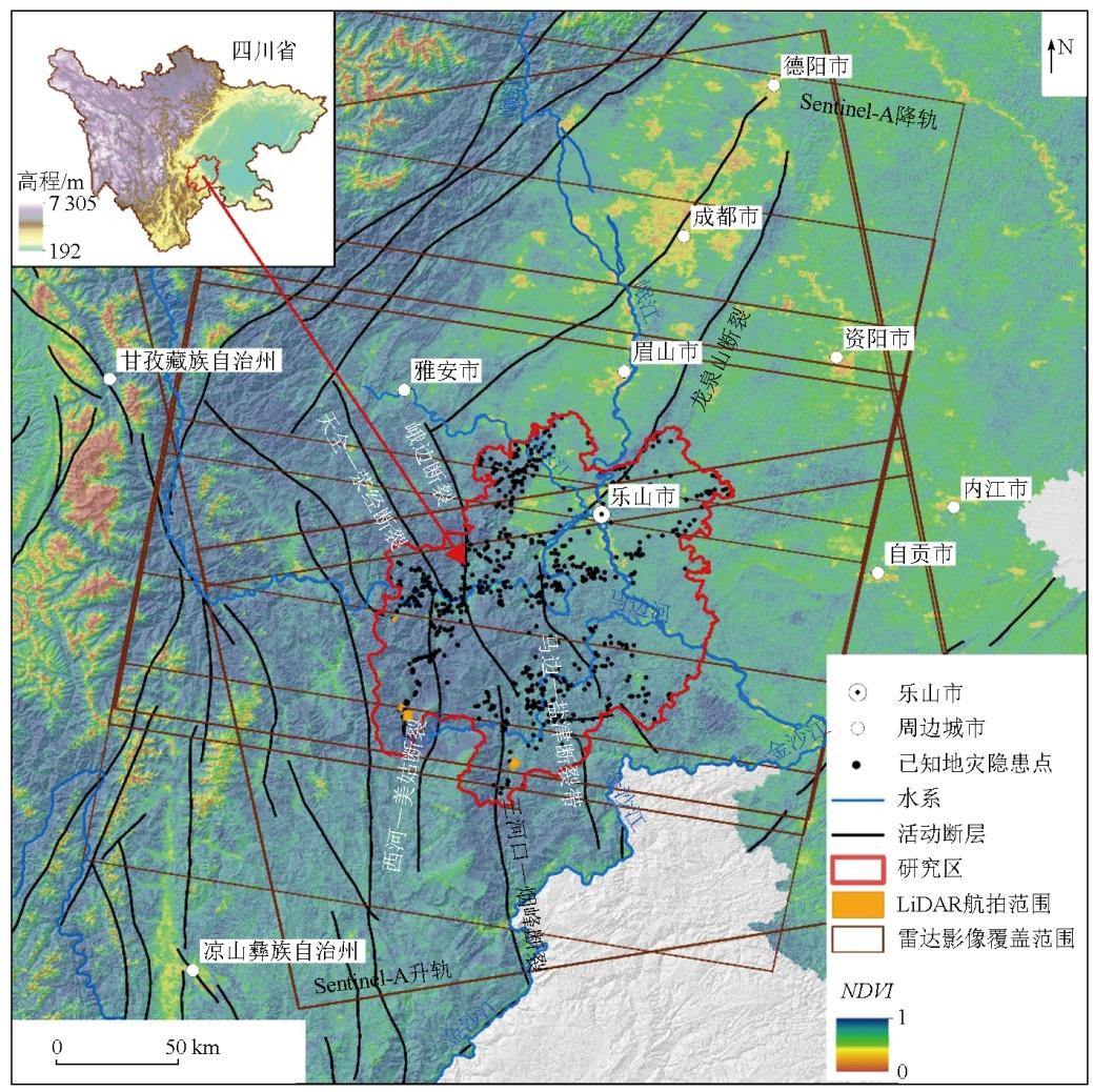
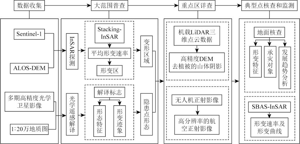
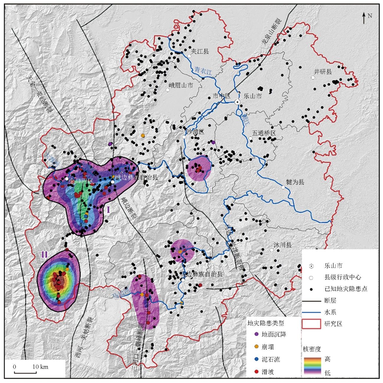
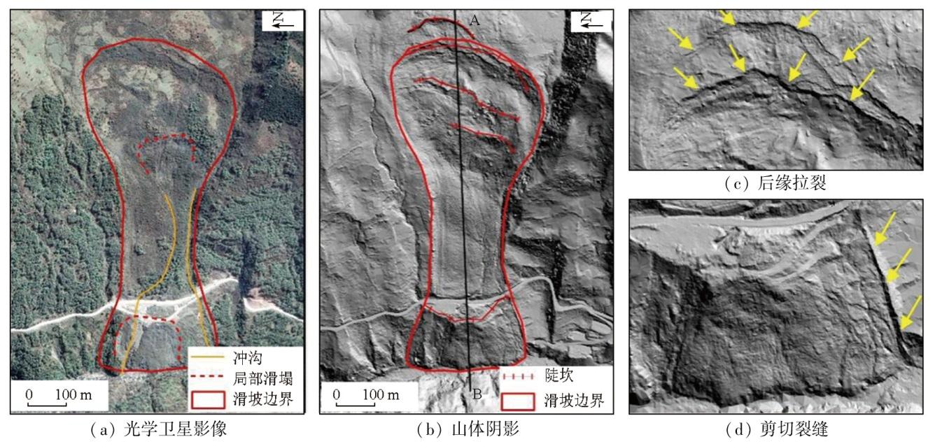
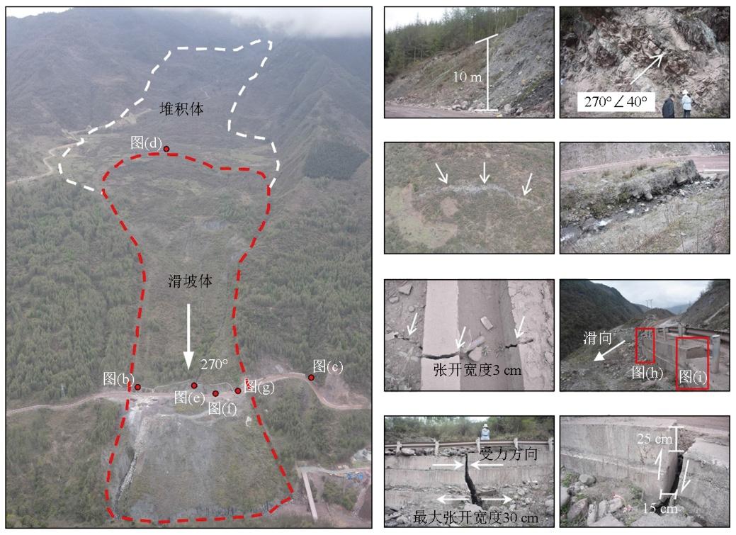
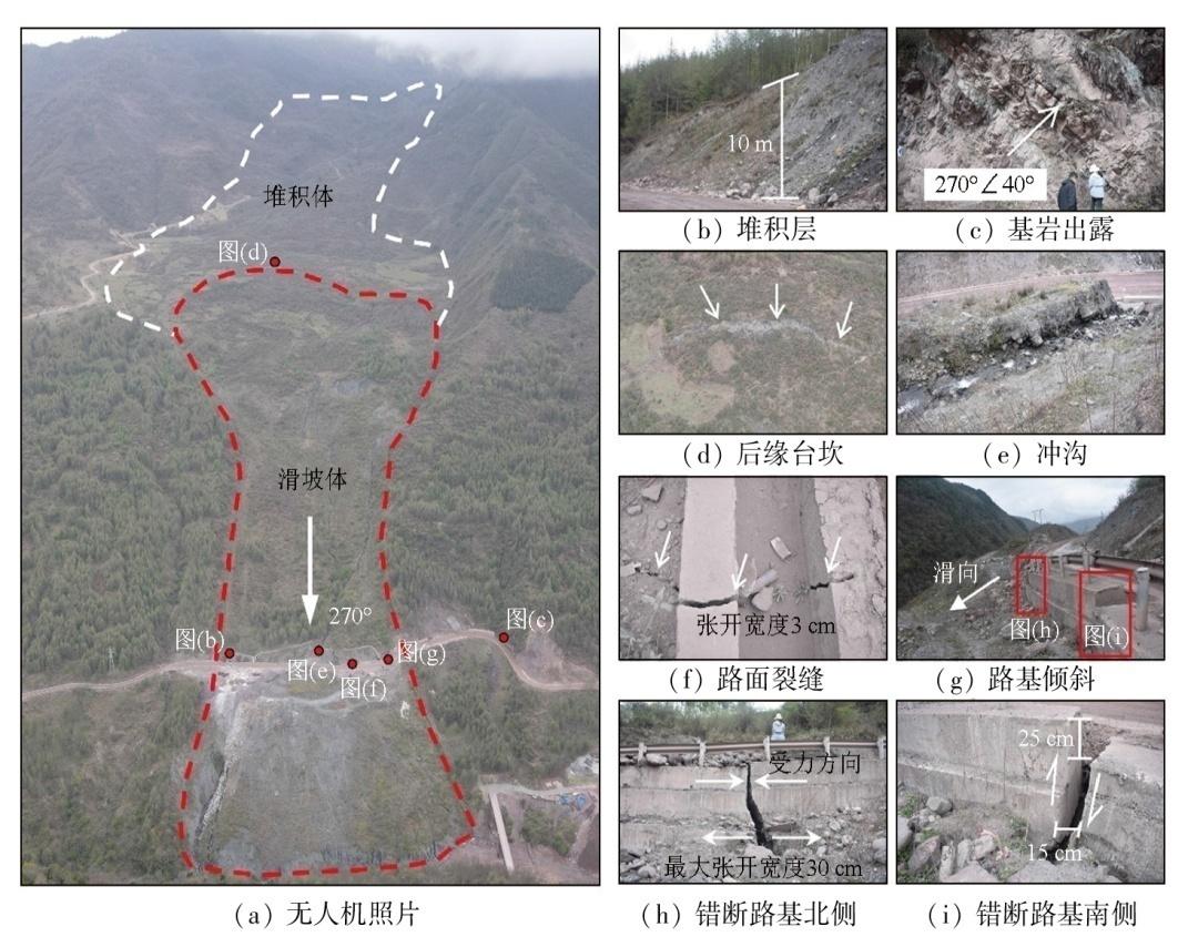
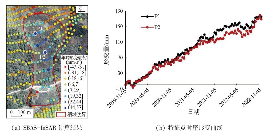
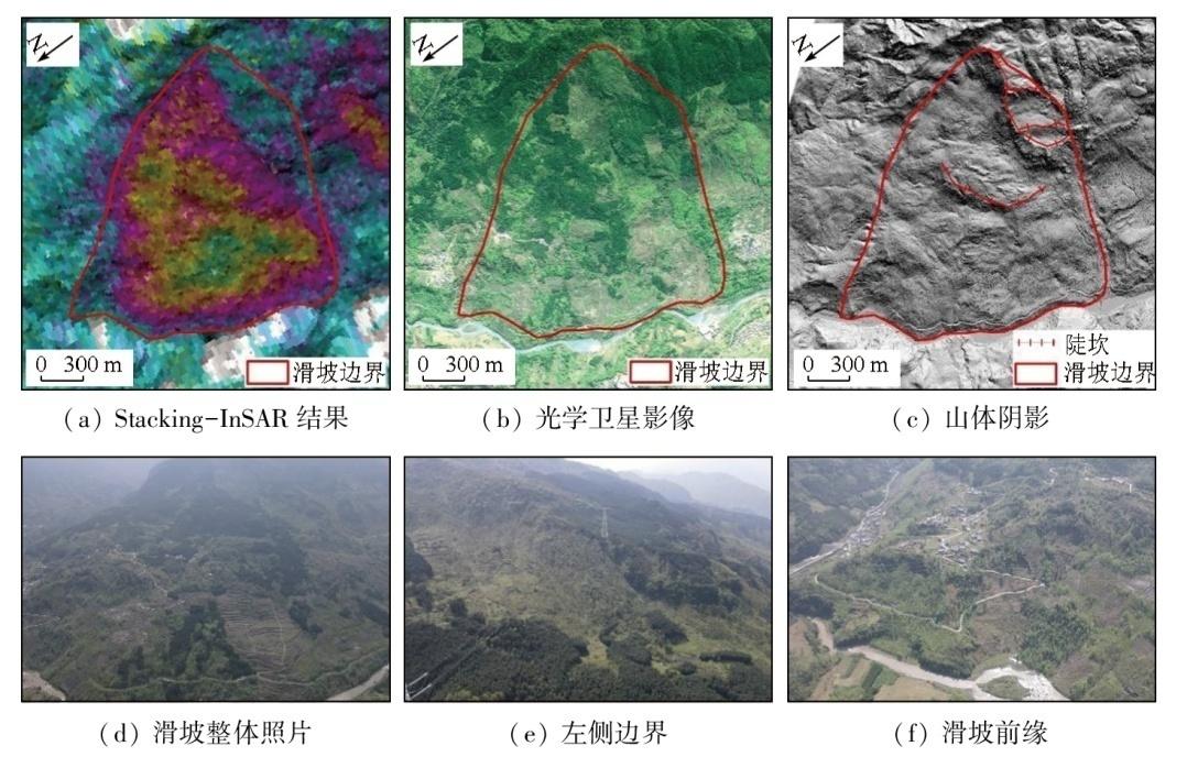
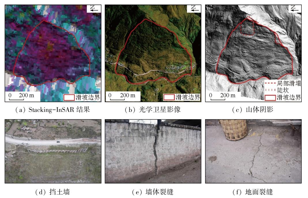
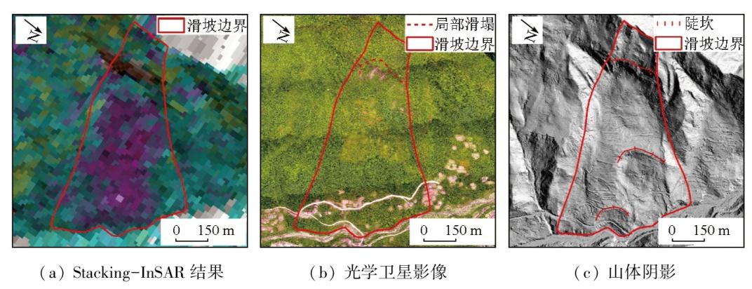
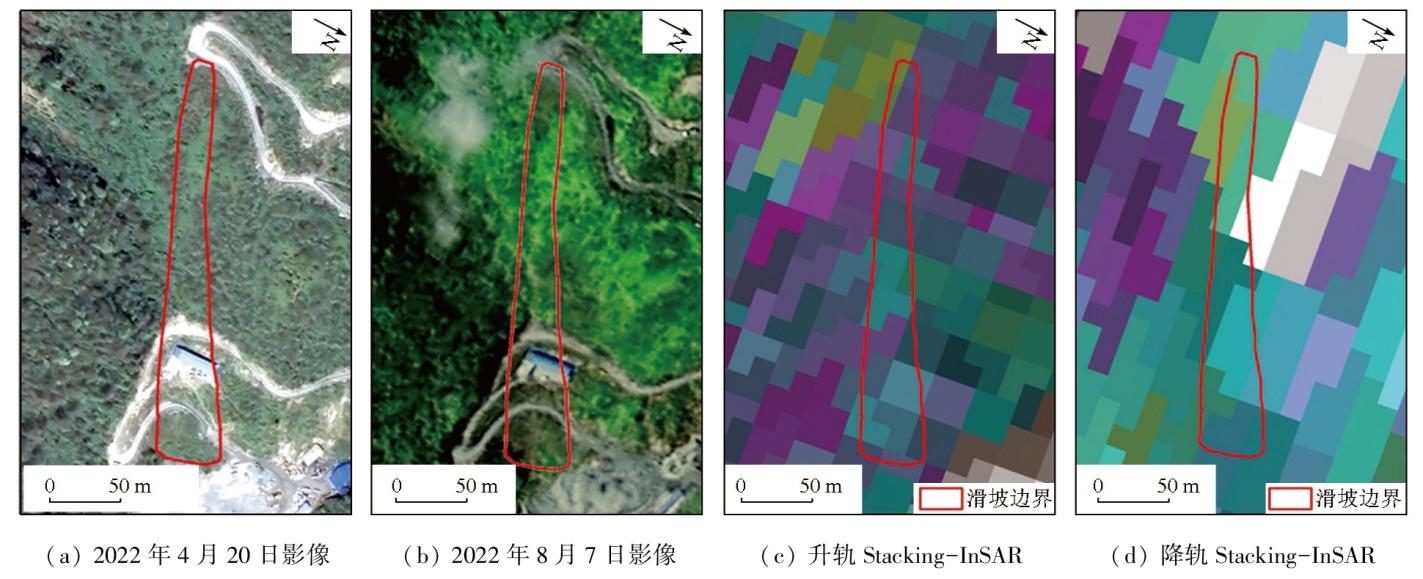
自天-空-地一体化的“三查”体系提出以来,地质灾害隐患识别与监测示范性工作取得显著成效。四川省乐山市是示范区中的地质灾害重点防治区,高植被覆盖率和集中降雨导致地质灾害具有高位隐蔽和突发性。该文以乐山市为研究区,采用天-空-地一体化的“三查”技术体系,开展高植被山区地质灾害隐患识别与监测应用研究。主要得出以下结论: ①研究区共识别地质灾害隐患75处,通过现场核查确认地质灾害隐患解译数为51处,识别准确率为68%,新识别隐患点36处; ②地质灾害隐患主要集中分布在2个区域,集中区内识别地质灾害隐患37处,占研究区地质灾害隐患的72.5%; ③Stacking-InSAR可以作为斜坡初始变形阶段的地质灾害识别手段; 斜坡处于显著变形阶段且在InSAR探测能力范围内时,Stacking-InSAR、高分辨率光学卫星影像、LiDAR均能作为地质灾害识别的技术手段; ④在高植被覆盖的山区,可利用LiDAR技术去除地表植被的影响,结合一定的专家经验开展地质灾害隐患识别工作; ⑤目前利用遥感手段很难对“非显性地质灾害隐患”进行有效识别。
周胜森 , 李为乐 , 陆会燕 , 任娟 , 付豪 , 李雪清 , 王新程 , 李雨森 , 韦春豪 . “三查”体系在高植被山区地质灾害隐患识别与监测中的应用——以四川省乐山市为例[J]. 自然资源遥感, 2025 , 37(3) : 221 -232 . DOI: 10.6046/zrzyyg.2024020
The space-air-ground investigation system has achieved remarkable results in the identification and monitoring demonstration work of geohazards. Leshan City in Sichuan Province, China, is a key zone for preventing and controlling geohazards within the demonstration area. The high vegetation cover and concentrated rainfall lead to the high concealment and sudden occurrence of geohazards in Leshan City, necessitating the identification and monitoring of geohazards in this city. Hence, under the guidance of the space-air-ground investigation system, this study explored the identification and monitoring of geohazards in the highly vegetation-covered mountain areas within Leshan City. The results indicate that 75 geohazards were identified in the study areas, with 51 confirmed through field verification, suggesting an identification accuracy rate of 68 %. Among them, 36 geohazards were newly identified. The geohazards were primarily concentrated in two areas, where 37 were identified, representing 72.5 % of the total geohazards in the study areas. Concerning techniques for identifying geohazards at different deformation stages of slopes, stacking-interferometric synthetic aperture radar (InSAR) can be employed to detect geohazards at the initial deformation stage of slopes. For slopes experiencing significant deformation within the detection range of InSAR, techniques like stacking-InSAR, high-resolution optical satellite imagery, and light detection and ranging (LiDAR) can all be used for geohazard identification. For highly vegetation-covered mountain areas, the LiDAR technique, which can be utilized to remove the effects of surface vegetation, combined with expert knowledge, can be used for geohazard identification. Additionally, remote sensing techniques face challenges in effectively identifying concealed geohazards.
表1 地质灾害隐患县域识别准确率统计表Tab.1 Accuracy rate of identification of potential geohazards |
| 县域 | 识别 总数/处 | 确认为隐患 数/处 | 准确率/% |
|---|---|---|---|
| 峨边彝族自治县 | 40 | 34 | 85.0 |
| 峨眉山市 | 2 | 2 | 100.0 |
| 金口河区 | 8 | 3 | 37.5 |
| 马边彝族自治县 | 15 | 9 | 60.0 |
| 沐川县 | 2 | 0 | 0.0 |
| 沙湾区 | 8 | 3 | 37.5 |
| 合计 | 75 | 51 | 68.0 |
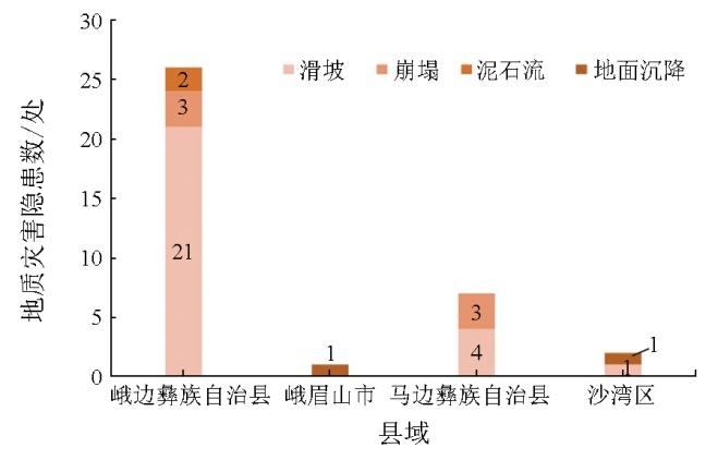
表2 地质灾害隐患统计表Tab.2 Number of potential geohazards(处) |
| 县域 | 地质灾害隐患类型 | 合计 | |||
|---|---|---|---|---|---|
| 滑坡 | 崩塌 | 泥石流 | 地面沉降 | ||
| 峨边彝族自治县 | 29 | 3 | 2 | — | 34 |
| 峨眉山市 | — | 1 | — | 1 | 2 |
| 金口河区 | 3 | — | — | — | 3 |
| 马边彝族自治县 | 6 | 3 | — | — | 9 |
| 沙湾区 | 2 | — | — | 1 | 3 |
| 合计 | 39 | 7 | 2 | 3 | 51 |
感谢成都理工大学郁文龙、单云锋、余淙蔚、许善淼、张攀、李维敏等同学在数据处理、地质灾害隐患识别和野外调查中对本文的帮助。
| [1] |
|
| [2] |
葛大庆. 地质灾害早期识别与监测预警中的综合遥感应用[J]. 城市与减灾, 2018(6):53-60.
|
| [3] |
徐红. 地质灾害:由群防到技防——访自然资源部地质灾害防治技术指导中心首席科学家殷跃平[J]. 中国测绘, 2020(7):8-11.
|
| [4] |
梁京涛, 赵聪, 马志刚. 多源遥感技术在地质灾害早期识别应用中的问题探讨——以西南山区为例[J]. 中国地质调查, 2022, 9(4):92-101.
|
| [5] |
陈舒. 点面双控探寻护佑生命之路[N]. 中国自然资源报,2023-05-08(003).
|
| [6] |
许强. 对地质灾害隐患早期识别相关问题的认识与思考[J]. 武汉大学学报(信息科学版), 2020, 45(11):1651-1659.
|
| [7] |
|
| [8] |
|
| [9] |
梁京涛, 成余粮, 王军, 等. 2013年7月10日四川省都江堰三溪村五里坡特大滑坡灾害遥感调查及成因机制浅析[J]. 工程地质学报, 2014, 22(6):1194-1203.
|
| [10] |
|
| [11] |
|
| [12] |
刘传正. 浙江遂昌县苏村崩塌滑坡灾害[J]. 中国地质灾害与防治学报, 2016, 27(4):12.
|
| [13] |
|
| [14] |
李华, 史文兵, 朱要强, 等. 贵州省水城县“7·23”灾难性滑坡形成机制研究[J]. 自然灾害学报, 2020, 29(6):188-198.
|
| [15] |
许强, 董秀军, 李为乐. 基于天-空-地一体化的重大地质灾害隐患早期识别与监测预警[J]. 武汉大学学报(信息科学版), 2019, 44(7):957-966.
|
| [16] |
陈舒. 地灾隐患识别:寻找大地上的“潜伏者”[N]. 中国自然资源报,2021-05-10(003).
|
| [17] |
李永建, 唐得胜, 马志刚. 四川省地质灾害防治形势及对策研究[J]. 四川地质学报, 2020, 40(4):676-679.
|
| [18] |
虎啸天, 娜子布林, 彭旭东, 等. 乐山市地质灾害发育特征及其防治形势分析[J]. 四川建材, 2017, 43(5):200-201.
|
| [19] |
乔建平. 四川乐山地区红层滑坡特点研究[C]// 自然边坡稳定性分析暨华蓥山边坡变形趋势研讨会论文集. 重庆,1991:176-183.
|
| [20] |
严映峰, 何朝阳, 解明礼, 等. 乐山市张村沟泥石流工程地质特征及成因机制分析[J]. 人民长江, 2021, 52(10):152-158.
|
| [21] |
王昌强. 乐山五通桥区滑坡破坏特征与演化机制研究[J]. 西部探矿工程, 2020, 32(12):20-23.
|
| [22] |
赵娜, 钟家彬. 乐山市金口河区大渡河沿岸崩塌地质灾害发育特征[J]. 地质灾害与环境保护, 2017, 28(4):26-30.
|
| [23] |
张德, 钟家彬. 乐山市金口河区大渡河沿岸泥石流地质灾害发育特征[J]. 地质灾害与环境保护, 2017, 28(4):17-21.
|
| [24] |
赵娜, 钟家彬, 杨东明. 乐山市金口河区大渡河沿岸滑坡地质灾害发育特征[J]. 地质灾害与环境保护, 2016, 27(2):10-14.
|
| [25] |
付豪, 李为乐, 陆会燕, 等. 基于“三查”体系的丹巴县滑坡隐患早期识别与监测[J]. 武汉大学学报(信息科学版), 2024, 49(5):734-746.
|
| [26] |
刘国祥, 陈强, 罗小军, 等. InSAR原理与应用[M]. 北京: 科学出版社, 2019.
|
| [27] |
王治华. 滑坡遥感[M]. 北京: 科学出版社, 2012.
|
| [28] |
卓宝熙. 工程地质遥感判释与应用(第2版)[M]. 北京: 中国铁道出版社, 2011.
|
| [29] |
|
| [30] |
|
/
| 〈 |
|
〉 |
