
基于多源遥感影像的西藏白格滑坡失稳前后全过程形变监测研究
|
杨成生(1982-),男,教授,主要从事地质灾害监测与机理反演相关研究。Email: yangchengsheng@chd.edu.cn。 |
Office editor: 陈庆
收稿日期: 2024-01-09
修回日期: 2024-04-10
网络出版日期: 2026-06-03
基金资助
国家重点研发计划项目“广域重大地质灾害隐患综合遥感识别技术研发”(2021YFC3000404)
国家自然科学基金项目“高分时序InSAR技术解译地裂缝时空形变与反演研究”(42174032)
长安大学中央高校基本科研业务费专项资金项目“青藏高原冰冻圈灾害监测技术研究”(CHD300102262206)
Whole-process deformation monitoring of the Baige landslide in Tibet before and after instability based on multisource remote sensing images
Received date: 2024-01-09
Revised date: 2024-04-10
Online published: 2026-06-03
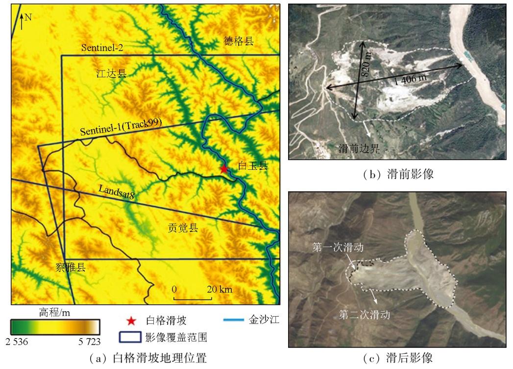
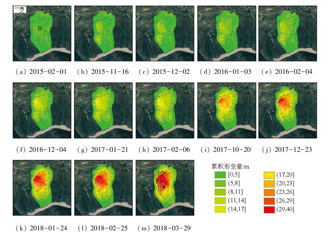
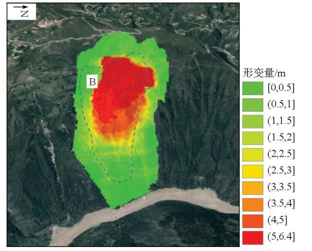
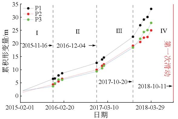
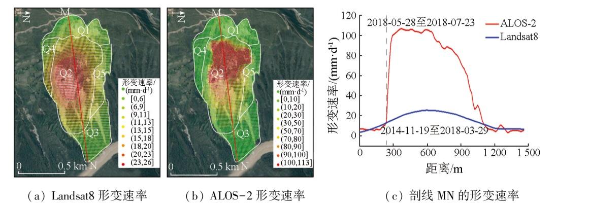
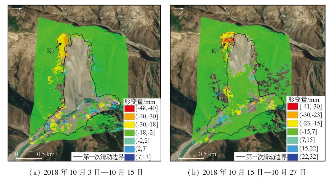
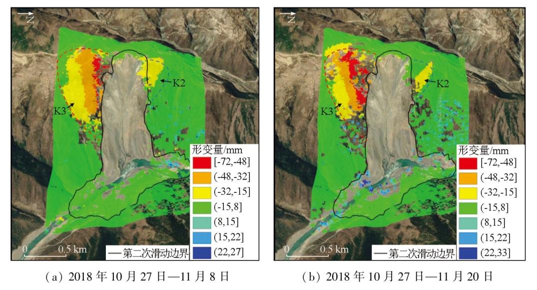
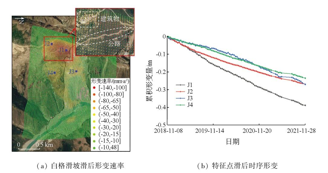
西藏白格滑坡于2018年10月和11月先后发生2次崩滑,造成了巨大的经济损失和广泛的社会影响。利用多源数据开展滑坡各阶段活动特征监测对理解此次滑坡事件的破坏机理具有重要意义。该文采用Sentinel-1,ALOS-2和Landsat8 3种数据源,通过短基线集合成孔径雷达干涉测量技术(small baseline subset interferometric synthetic aperture Radar,SBAS-InSAR)和SAR偏移量以及光学偏移量跟踪技术获取了白格滑坡滑前、2次滑动和滑后的形变特征。光学偏移量计算结果表明,白格滑坡在2014年11月—2018年3月29日的滑前阶段,累积位移量达到40 m,其形变区为滑坡中部。SAR偏移量结果也表明该滑坡在滑前2018年5月与7月的累积位移量达到了6.4 m,其形变区同样为滑坡中部。基于InSAR技术的监测结果揭示了白格滑坡2018年10月—11月2次失稳后,在滑坡后缘和滑坡左上侧仍存在明显的残余形变。白格滑坡在2018年11月—2021年11月滑后阶段,在滑坡的后缘高位处仍存在-140 mm/a的形变,且滑坡左上侧形变范围在持续扩大。该研究成果恢复了白格滑坡大量级位移的滑动全过程,为滑坡监测及预警研究提供了参考。
关键词: 白格滑坡; SBAS-InSAR; 偏移量跟踪技术; 全过程; 形变监测
杨成生 , 魏春蕊 , 魏云杰 , 李祖锋 , 丁慧兰 . 基于多源遥感影像的西藏白格滑坡失稳前后全过程形变监测研究[J]. 自然资源遥感, 2025 , 37(3) : 203 -211 . DOI: 10.6046/zrzyyg.2024015
The Baige landslide occurred twice in October and November 2018, causing huge economic losses and extensive social impact. Monitoring the activity characteristics of the Baige landslide in various stages based on multisource data is significant for understanding the failure mechanism of this landslide. With Sentinel-1, ALOS-2, and Landsat8 data as data sources, this study derived the deformation characteristics of the Baige landslide before, during, and after two slide events using techniques, such as small baseline subset-interferometric synthetic aperture radar (SBAS-InSAR), SAR offset tracking, and optical offset tracking. The optical offset calculation results show that from November 2014 to March 29, 2018 in the pre-sliding stage, the cumulative displacement of the Baige landslide reached 40 m, with deformation concentrated in the middle of the landslide. The SAR offset results indicate that the cumulative displacement of the landslide reached 6.4 m in May and July 2018 in the pre-sliding stage, with deformation also concentrated in the middle of the landslide. The InSAR-based monitoring results reveal that after the two failures of the Baige landslide in October and November 2018, significant residual deformation remained in the trailing edge and upper left side of the landslide. From November 2018 to November 2021 in the post-sliding stage, the Baige landslide exhibited a deformation rate of -140 mm/y at the high trailing edge of the landslide, and the deformation range on the upper left side continued to expand. All the results of this study reconstructed the whole sliding process of the Baige landslide subjected to large displacements, providing a valuable reference for the monitoring and early warning of landslides.
表1 采用的SAR数据集主要参数Tab.1 Main parameters of the SAR dataset used |
| SAR数据 | Sentinel-1 | ALOS-2 |
|---|---|---|
| 轨道方向 | 升轨 | 升轨 |
| 轨道号 | 99 | — |
| 入射角/(°) | 33.9 | 36.2 |
| 方位角/(°) | -10.1 | 90 |
| 成像模式 | IW宽幅模式 | PALSAR2 |
| 极化方式 | VV | HH |
| 影像数量/景 | 85 | 2 |
| 影像时间间隔/d | 12 | 56 |
| 影像时间范围 | 2018年11月— 2021年11月 | 2018年5月28日, 2018年7月23日 |
表2 采用的光学数据集主要参数Tab.2 Main parameters of the optical dataset used |
| 序号 | 数据源 | 影像 | 太阳高 度角/(°) | 太阳方 位角/(°) | 序号 | 数据源 | 影像 | 太阳高 度角/(°) | 太阳方 位角/(°) |
|---|---|---|---|---|---|---|---|---|---|
| 1 | Landsat8 | 2014-11-29 | 33.838 3 | 158.818 0 | 8 | Landsat8 | 2017-01-21 | 33.256 1 | 152.079 2 |
| 2 | Landsat8 | 2015-02-01 | 35.408 1 | 150.056 2 | 9 | Landsat8 | 2017-02-06 | 36.815 7 | 149.023 3 |
| 3 | Landsat8 | 2015-11-16 | 36.762 2 | 158.626 6 | 10 | Landsat8 | 2017-10-20 | 44.497 5 | 154.835 2 |
| 4 | Landsat8 | 2015-12-02 | 33.341 8 | 158.725 2 | 11 | Landsat8 | 2017-12-23 | 31.108 4 | 156.833 1 |
| 5 | Landsat8 | 2016-01-03 | 31.180 0 | 155.324 6 | 12 | Landsat8 | 2018-01-24 | 33.748 1 | 151.531 9 |
| 6 | Landsat8 | 2016-02-04 | 36.098 4 | 149.556 6 | 13 | Landsat8 | 2018-02-25 | 42.578 0 | 145.266 3 |
| 7 | Landsat8 | 2016-12-04 | 32.900 5 | 158.631 4 | 14 | Landsat8 | 2018-03-29 | 54.207 2 | 137.820 0 |
表3 各类数据应用的描述与总结Tab.3 Description and summary of various data applications |
| 数据 | 监测时间 | 处理方法 | 观测类型 | 方法描述与适用性 | 白格滑坡应用阶段 |
|---|---|---|---|---|---|
| Sentinel-1 | 2018年11月8日—2021年11月28日 | SBAS-InSAR技术 | 雷达影像 | 重点区域定性/定量分析; 长时期观测序列,小量级形变监测; 结果为距离向和方位向形变量 | 第一次滑动和第二次滑动引起的后缘变形区监测; 滑后的长时序监测 |
| ALOS-2 | 2018年5月28日和2018年7月23日 | SAR偏移量 跟踪技术 | 雷达影像 | 大量级的形变监测; 较高分辨率雷达影像使结果精度 更高; 结果为距离向和方位向偏移量 | 滑前的大量级位移 获取 |
| Landsat8 | 2014年11月29日—2018年3月29日 | 光学偏移量跟踪技术 | 光学影像 | 大量级的形变监测; 可利用数据量较多的光学影像; 结果为东西向和南北向偏移量 | 滑前的大量级长时间序列位移的获取 |
图4 2014年11月29日至不同日期的白格滑坡滑前光学偏移量时序累积形变结果Fig.4 Time series cumulative deformation results of optical offset before sliding of Baige landslide from November 29,2014 to different dates |
| [1] |
许强, 郑光, 李为乐, 等. 2018年10月和11月金沙江白格两次滑坡-堰塞堵江事件分析研究[J]. 工程地质学报, 2018, 26(6):1534-1551.
|
| [2] |
|
| [3] |
|
| [4] |
|
| [5] |
范景辉, 邱阔天, 夏耶, 等. 三峡库区范家坪滑坡地表形变InSAR监测与综合分析[J]. 地质通报, 2017, 36(9):1665-1673.
|
| [6] |
朱同同, 史绪国, 周超, 等. 利用2016—2020年Sentinel-1数据监测与分析三峡库区树坪滑坡稳定性[J]. 武汉大学报(信息科学版) 2021, 46(10):1560-1568.
|
| [7] |
冯文凯, 顿佳伟, 易小宇, 等. 基于SBAS-InSAR技术的金沙江流域沃达村巨型老滑坡形变分析[J]. 工程地质学报, 2020, 28(2):384-393.
|
| [8] |
|
| [9] |
|
| [10] |
|
| [11] |
王群, 张蕴灵, 范景辉, 等. 基于PS-InSAR和offset tracking技术的金沙江白格滑坡形变监测[J]. 大地测量与地球动力学, 2020, 40(4):340-345.
|
| [12] |
柳林, 宋豪峰, 杜亚男, 等. 联合哨兵2号和Landsat8估计白格滑坡时序偏移量[J]. 武汉大学学报(信息科学版), 2021, 46(10):1461-1470.
|
| [13] |
徐小波, 马超, 单新建, 等. 联合DInSAR与Offset-tracking技术监测高强度采区开采沉陷的方法[J]. 地球信息科学学报, 2020, 22(12):2425-2435.
|
| [14] |
孙军, 张锦. 基于SBAS-InSAR和偏移追踪技术的露天煤矿地面形变监测[J]. 煤矿安全, 2022, 53(3):162-169.
|
| [15] |
黄洁慧, 谢谟文, 王立伟. 基于SBAS-InSAR技术的白格滑坡形变监测研究[J]. 人民长江, 2019, 50(12):101-105.
|
| [16] |
莫玉娟, 吴洋, 刘学武. 基于SBAS技术的四川阿坝州小金县地表形变监测[J]. 测绘工程, 2018, 27(11):46-50.
|
| [17] |
高文锦. 基于SBAS-InSAR技术的深圳西部地区地表形变研究[D]. 西安: 西安科技大学, 2021.
|
| [18] |
|
| [19] |
|
| [20] |
贺礼家, 冯光财, 冯志雄, 等. 哨兵-2号光学影像地表形变监测:以2016年MW7.8新西兰凯库拉地震为例[J]. 测绘学报, 2019, 48(3):339-351.
|
| [21] |
|
| [22] |
|
/
| 〈 |
|
〉 |
