
级联改进DexiNed和DeepLabv3+网络的坡耕地提取
|
刘超兵(1999-),男,硕士研究生,主要研究方向为三维激光点云技术应用。Email: 1433065161@qq.com。 |
Copy editor: 张仙
收稿日期: 2023-11-03
修回日期: 2024-04-02
网络出版日期: 2026-06-03
基金资助
国家自然科学基金项目“禄丰环状构造的UAV数字地貌建模及地表特征测量模拟分析”(62266026)
Extracting the information on sloping arable land based on improved DexiNed and DeepLabv3+ networks in a cascade connection
Received date: 2023-11-03
Revised date: 2024-04-02
Online published: 2026-06-03
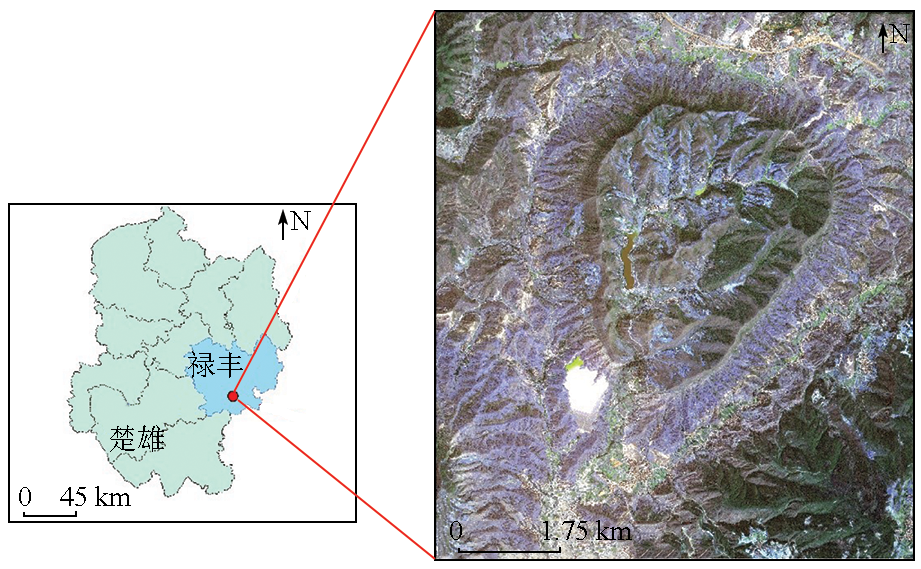
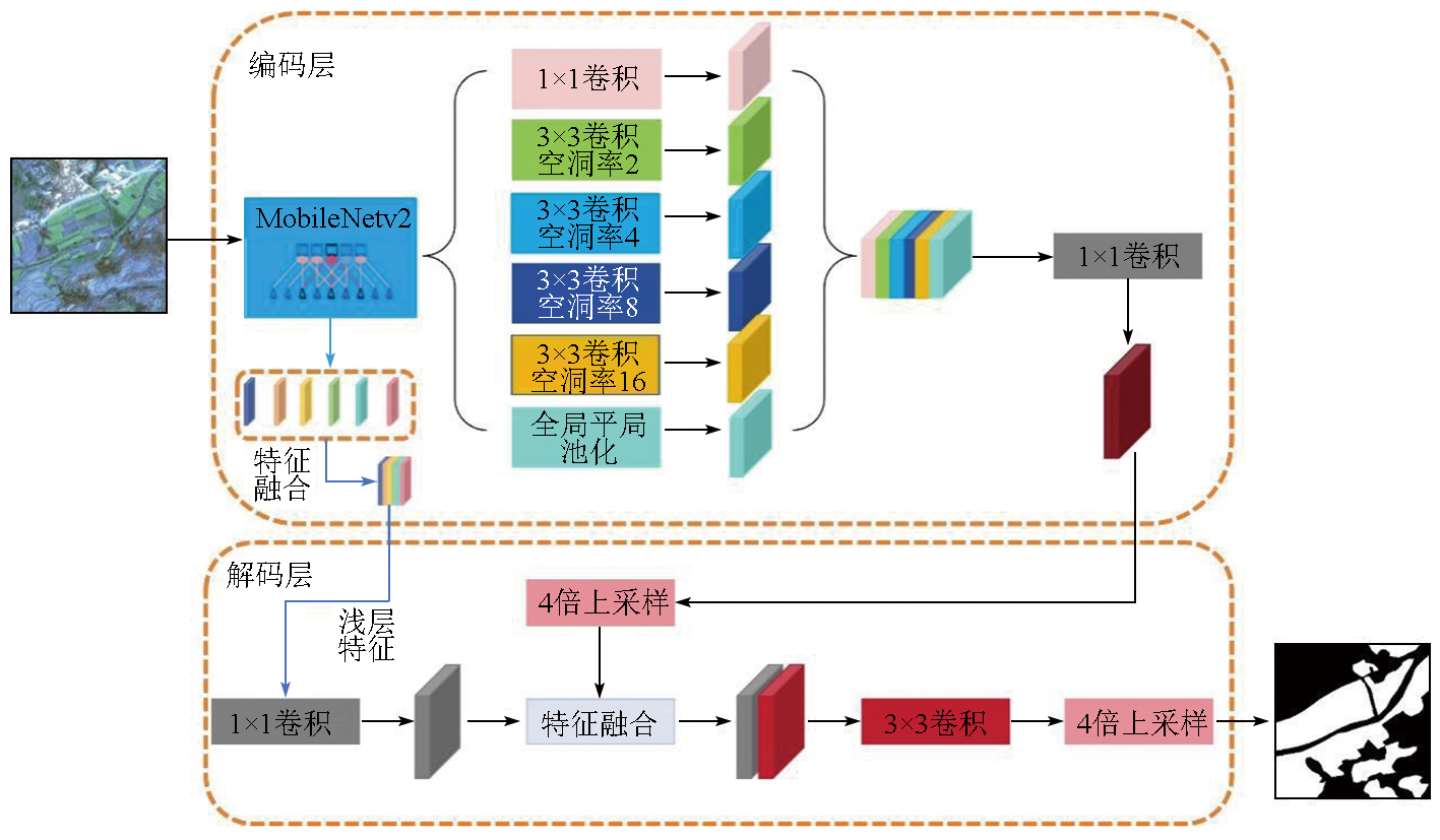
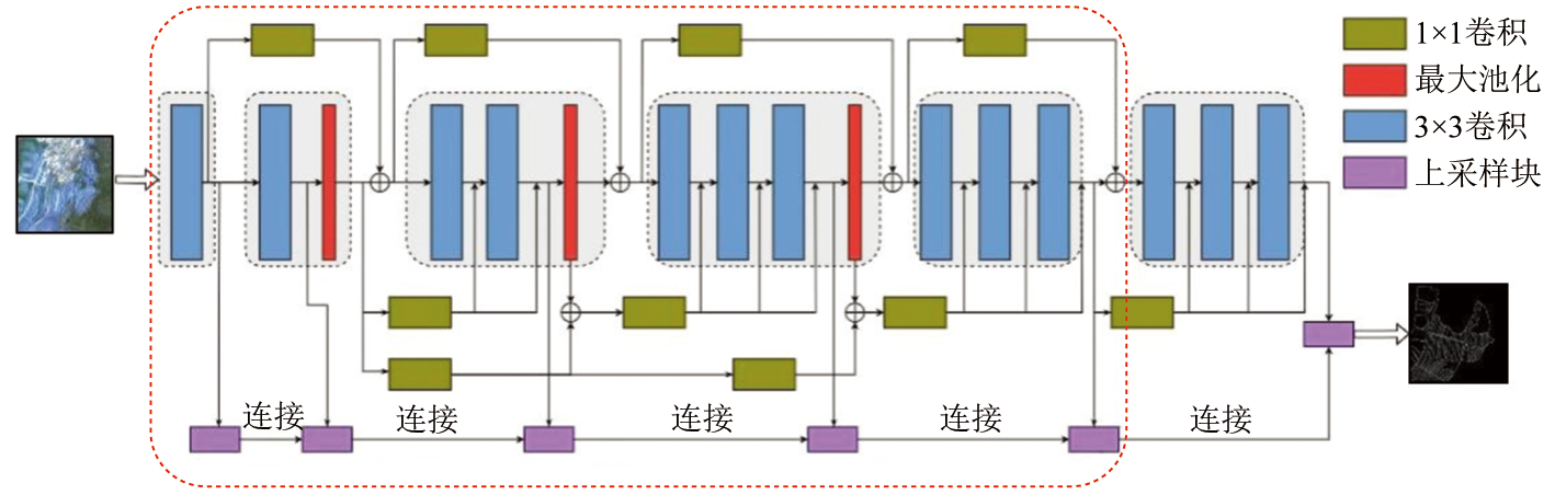
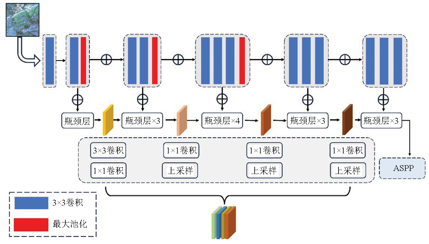
丘陵山地区域耕地细小狭窄、结构复杂且边界模糊,使得耕地信息难以迅速、准确地获取。针对上述问题,提出一种级联改进DexiNed和DeepLabv3+网络的坡耕地信息提取模型。首先,采用MobileNetv2替换原有的Xception模型作为DeepLabv3+模型主干网络,并提出一种联系较为紧密的低层次信息提取方法,将较低层次信息和较高层次信息初步融合来作为原低层次信息的输入; 其次,将原DeepLabv3+模型空洞空间金字塔池化(atrous spatial pyramid pooling,ASPP)模块的空洞率值优化为空洞率值分别为2,4,8,16的空洞卷积操作; 最后,采用级联边缘检测技术实现耕地地块边缘和语义特征的互联互通。该文以GF-2影像为数据源,云南禄丰恐龙谷为试验区进行耕地提取。实验结果表明,通过改进后的模型架构和算法,能更准确地识别耕地区域,提取结果与真实耕地标注的图像更为接近,漏提和误提区域减少,整体精度和稳定性提高。
关键词: 耕地信息提取; 边缘检测; DeepLabv3+; 丘陵山地
刘超兵 , 甘淑 , 袁希平 , 尚华胜 . 级联改进DexiNed和DeepLabv3+网络的坡耕地提取[J]. 自然资源遥感, 2025 , 37(2) : 49 -55 . DOI: 10.6046/zrzyyg.2023332
Arable land in hilly and mountainous areas exhibits small, narrow, and complex structures with blurred boundaries, posing challenges in extracting arable land information quickly and accurately. Hence, this study proposed a model for extracting the information on sloping arable land based on improved DexiNed and DeepLabv3+ networks in a cascade connection. First, the backbone network of the DeepLabv3+ model uses MobileNetV2 to replace the original Xception model. A closely related low-level information extraction method preliminarily fuses the lower- and higher-level information as the input of the original low-level information. Second, the original atrous spatial pyramid pooling (ASPP) module of the DeepLabv3+ model is optimized through dilated convolution, with dilation rate values of 2, 4, 8, and 16. Third, cascaded edge detection technology enables the interconnection of arable land edges and semantic features. The proposed model was applied to extract information on arable land in the Lufeng Dinosaur Valley in Yunnan Province using the GF-2 image as the data source. The results show that the proposed model with an improved architecture and algorithm identified the arable land more accurately, with the extraction results closely matching the image with real arable land annotated. With reduced extraction missing and errors, the proposed model exhibits enhanced accuracy and stability overall.
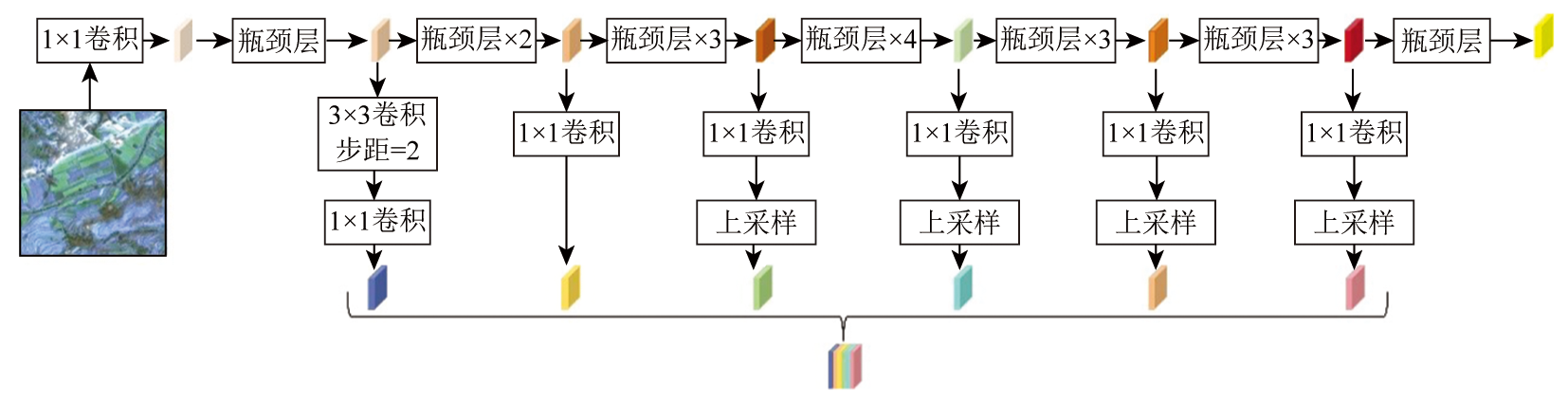
表1 MobileNetv2网络模块参数Tab.1 Parameters of MobileNetv2 network module |
| 输入 | 操作 | 通道数 | 瓶颈层重 复次数 | 步幅 |
|---|---|---|---|---|
| 512×512×3 | 卷积 | 32 | 1 | 2 |
| 256×256×32 | 瓶颈层 | 16 | 1 | 1 |
| 256×256×16 | 瓶颈层 | 24 | 2 | 2 |
| 128×128×24 | 瓶颈层 | 32 | 3 | 2 |
| 64×64×32 | 瓶颈层 | 64 | 4 | 2 |
| 32×32×64 | 瓶颈层 | 96 | 3 | 1 |
| 32×32×96 | 瓶颈层 | 160 | 3 | 2 |
| 16×16×160 | 瓶颈层 | — | 1 | 1 |
表2 山地区耕地提取结果对比分析图Tab.2 Comparative analysis of cultivated land extraction results in mountainous areas |
| 序号 | 遥感图像 | 真实标注 | 本文方法 | 级联未 改进方法 | DeepLabv3+ 方法 | 本文方法 提取结果 | 级联未改 进提取结果 | DeepLabv3+ 提取结果 |
|---|---|---|---|---|---|---|---|---|
| 1 | 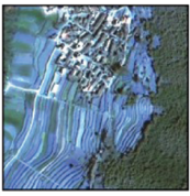 | 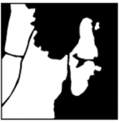 | 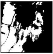 | 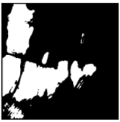 | 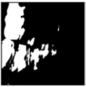 | 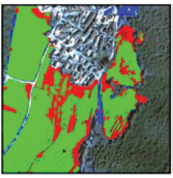 | 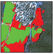 | 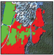 |
| 2 | 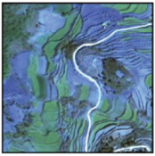 | 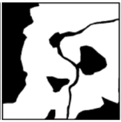 | 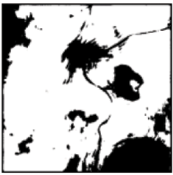 | 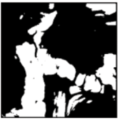 | 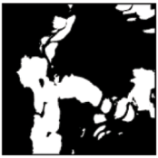 | 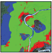 | 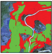 | 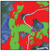 |
| 3 | 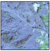 |  | 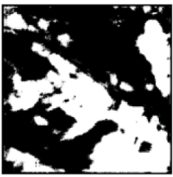 | 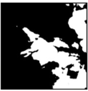 | 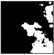 |  | 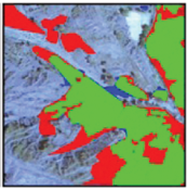 | 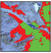 |
| 图例 |  | |||||||
表3 山地区耕地误提、漏提面积统计表Tab.3 Misextraction and omitting of cultivated land in mountainous areas |
| 山地区 | 真实耕地 面积/ hm2 | 误提面 积/hm2 | 误提 率/% | 漏提面 积/ hm2 | 漏提 率/% |
|---|---|---|---|---|---|
| 级联改进模型 | 340.19 | 28.44 | 8.36 | 23.61 | 6.94 |
| 级联未改进模型 | 29.39 | 8.64 | 30.51 | 8.97 | |
| DeepLabv3+模型 | 30.48 | 8.96 | 32.93 | 9.68 |
| [1] |
吴炳方, 张峰, 刘成林, 等. 农作物长势综合遥感监测方法[J]. 遥感学报, 2004, 8(6):498-514.
|
| [2] |
陈仲新, 任建强, 唐华俊, 等. 农业遥感研究应用进展与展望[J]. 遥感学报, 2016, 20(5):748-767.
|
| [3] |
史舟, 梁宗正, 杨媛媛, 等. 农业遥感研究现状与展望[J]. 农业机械学报, 2015, 46(2):247-260.
|
| [4] |
刘大伟, 韩玲, 韩晓勇. 基于深度学习的高分辨率遥感影像分类研究[J]. 光学学报, 2016, 36(4):0428001.
|
| [5] |
张新长, 黄健锋, 宁婷. 高分辨率遥感影像耕地提取研究进展与展望[J]. 武汉大学学报(信息科学版), 2023, 48(10):1582-1590.
|
| [6] |
熊曦柳, 胡月明, 文宁, 等. 耕地遥感识别研究进展与展望[J]. 农业资源与环境学报, 2020, 37(6):856-865.
|
| [7] |
李爱农, 边金虎, 张正健, 等. 山地遥感主要研究进展、发展机遇与挑战[J]. 遥感学报, 2016, 20(5):1199-1215.
|
| [8] |
周楠, 杨鹏, 魏春山, 等. 地块尺度的山区耕地精准提取方法[J]. 农业工程学报, 2021, 37(19):260-266.
|
| [9] |
|
| [10] |
|
| [11] |
刘巍, 吴志峰, 骆剑承, 等. 深度学习支持下的丘陵山区耕地高分辨率遥感信息分区分层提取方法[J]. 测绘学报, 2021, 50(1):105-116.
|
| [12] |
|
| [13] |
|
| [14] |
|
| [15] |
|
| [16] |
|
| [17] |
|
| [18] |
|
| [19] |
|
| [20] |
高莎, 袁希平, 甘淑, 等. 基于无人机成像点云的禄丰恐龙谷南缘环状地貌空间特征探测实验分析[J]. 地质科技通报, 2021, 40(6):283-292.
|
| [21] |
陈佳俊. 基于GF-2卫星影像的川东丘陵地区耕地信息提取[D]. 成都: 成都理工大学, 2017.
|
| [22] |
|
| [23] |
|
| [24] |
|
/
| 〈 |
|
〉 |