
基于GEE平台多源遥感数据的海南岛红树林碳储量估算
|
李尉尉(1985-),女,硕士,工程师,主要从事海洋遥感应用研究。Email: rikki0909@163.com。 |
Copy editor: 陈昊旻
收稿日期: 2023-12-04
修回日期: 2024-03-05
网络出版日期: 2026-06-03
基金资助
海南省重点研发计划资助项目“南海珊瑚礁空天地海一体化监测关键技术研究与应用示范”(ZDYF2023GXJS023)
Estimating the carbon stocks of mangrove forests in Hainan Island based on multisource remote sensing data and Google Earth Engine
Received date: 2023-12-04
Revised date: 2024-03-05
Online published: 2026-06-03
关键词: 红树林; 碳储量; 生物量; Google Earth Engine; 海南岛
李尉尉 , 薛志泳 , 朱建华 , 田震 . 基于GEE平台多源遥感数据的海南岛红树林碳储量估算[J]. 自然资源遥感, 2025 , 37(2) : 220 -227 . DOI: 10.6046/zrzyyg.2023368
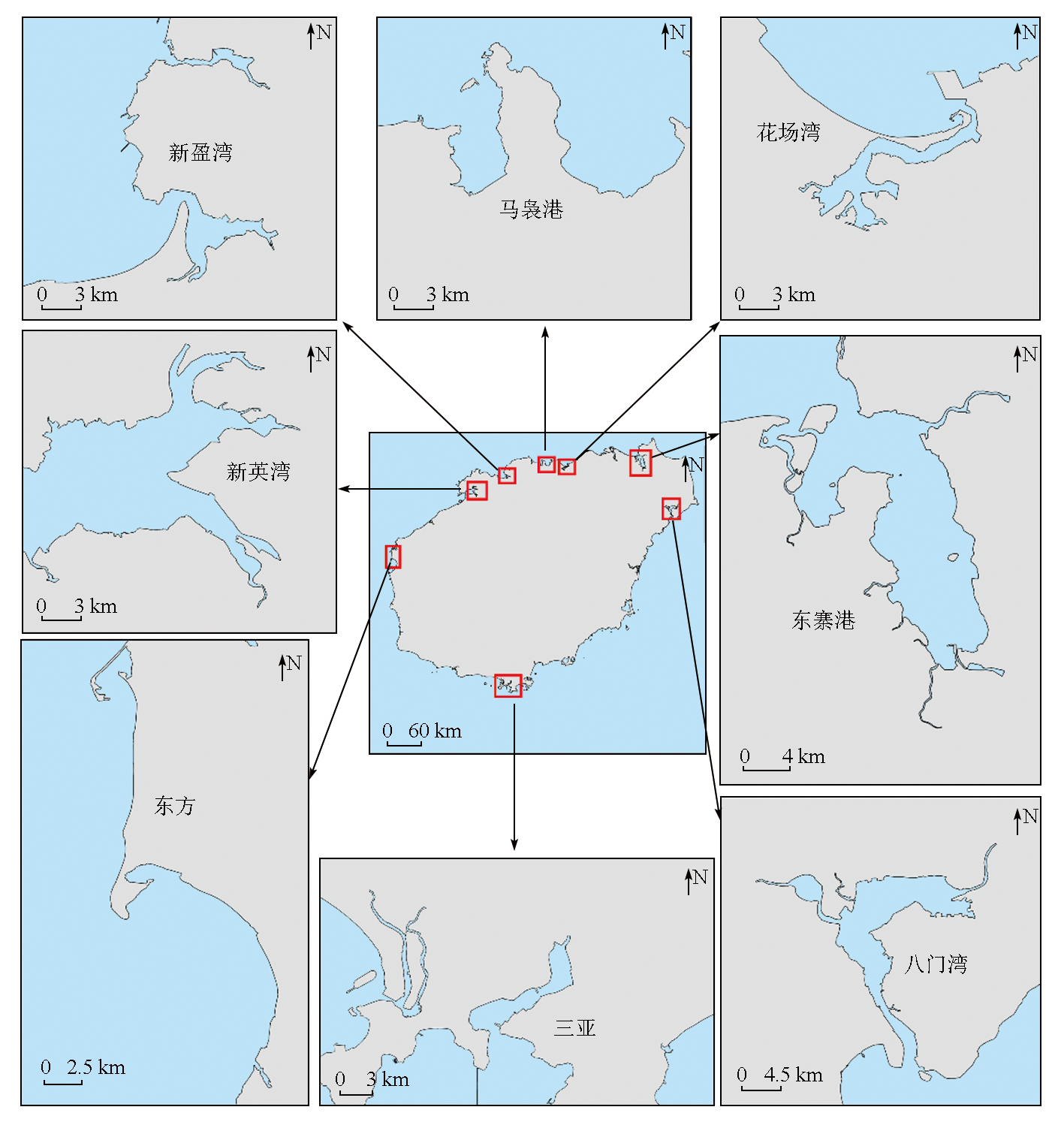
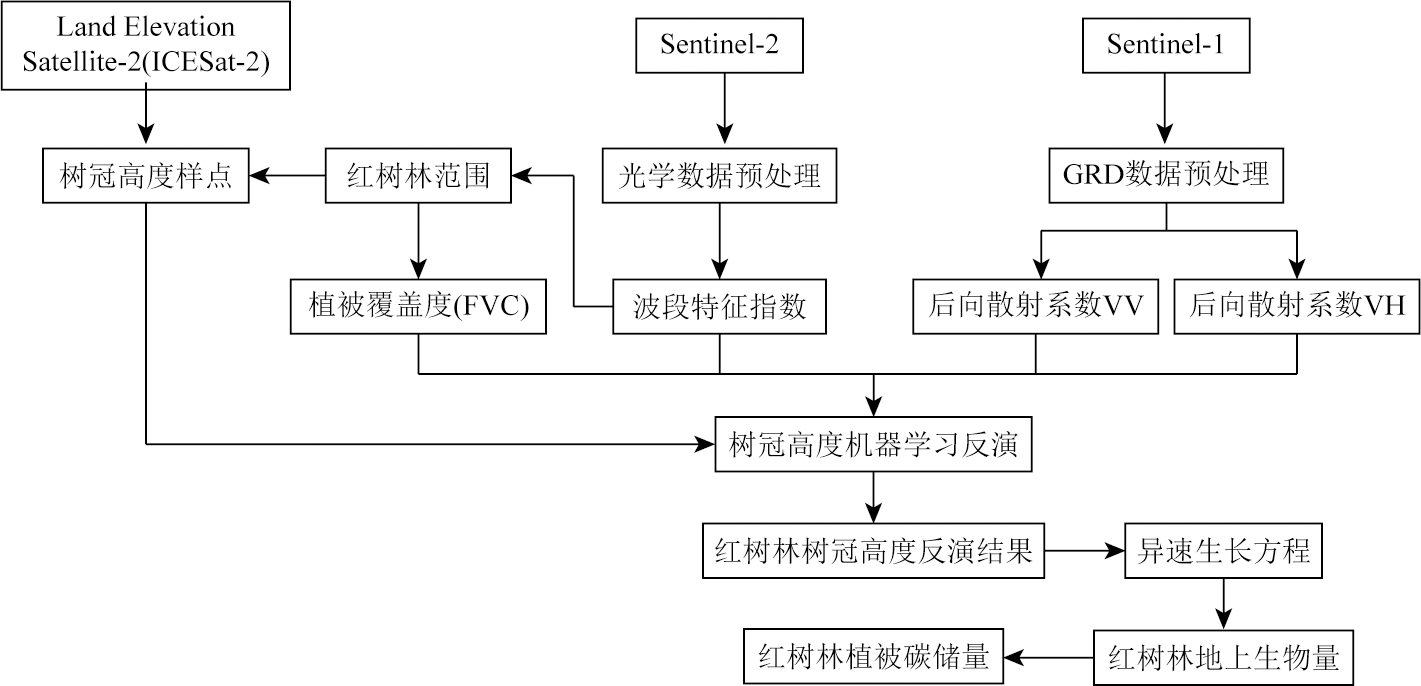
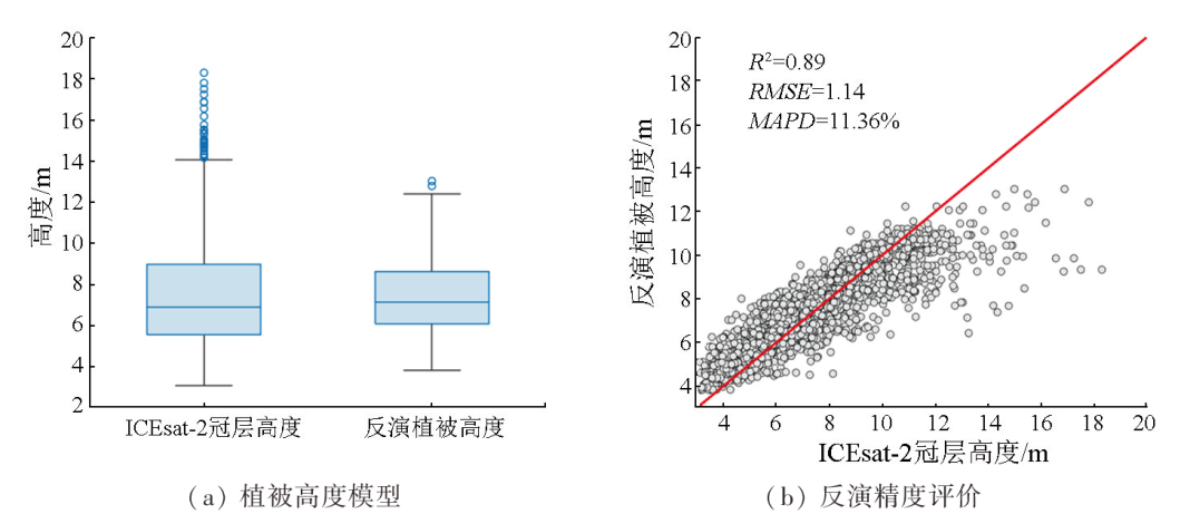
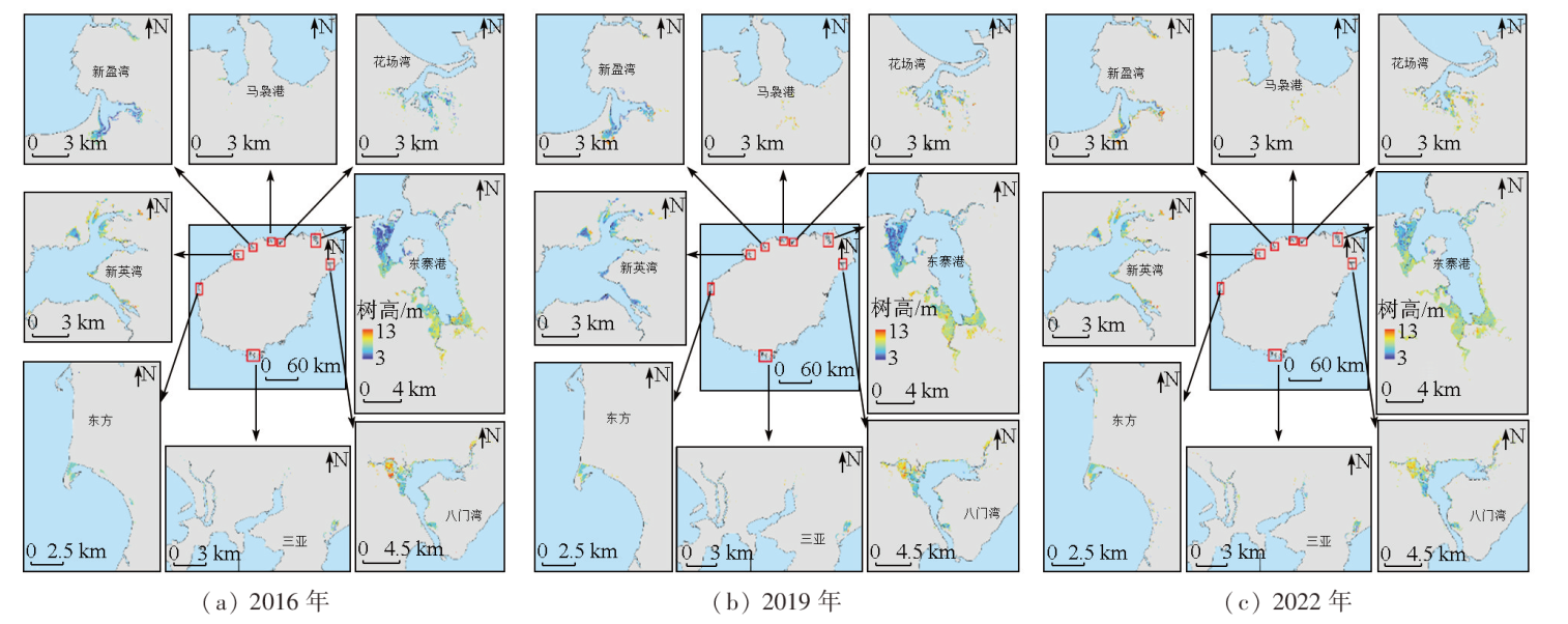
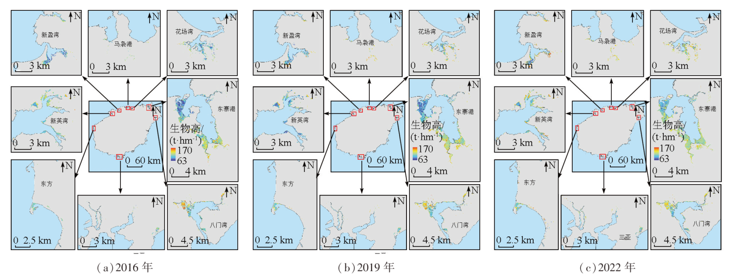
The change in carbon stocks is recognized as an important indicator of the carbon pool function. The effective, accurate assessment of carbon stocks is of great significance for research on regional carbon cycle and carbon source/sink dynamics, climate change mitigation, and regional sustainable development. Based on multi-time series remote sensing images (Sentinel-1 and Sentinel-2) and the Google Earth Engine (GEE) cloud computing platform, this study matched the photon point data of ICESat-2-derived vegetation canopy for the inversion of mangrove forest heights. Then, the inversion of the biomass of mangrove forests was conducted using a large-scale tree height-biomass model. Consequently, the heights, above-ground biomass, and carbon stocks of mangrove forests in Hainan Island were obtained, and their distribution and variations were further analyzed. The results indicate that in 2016, 2019, and 2022, mangrove forests in Hainan Island exhibited average heights of 6.99 m, 7.26 m, and 7.71 m, respectively, with an increasing trend observed in the highlights across all regions in the three years. Their total above-ground biomass was 400 939.48 t, 411 928.64 t, and 458 759.02 t, respectively, with average densities of 110.23 t/hm2, 114.61 t/hm2, and 120.02 t/hm2, respectively. The above-ground biomass of Dongzhai Port and the Bamenwan area, both located in the northeastern part of Hainan, accounted for about 80% of the total. The carbon stocks of mangrove forests exhibited rates of increase ranging from 1% to 4.45% over the three years, with the top two growth rates occurring in Dongzhai Port and the Bamenwan area, respectively (4.45% and 3.17%). The results of this study can provide foundational data and a methodological reference for assessing carbon stocks of large-scale mangrove forests and serve as important parameters for mangrove forest management and protection in Hainan Island, holding THE value of widespread applications.
Key words: mangrove forest; carbon stock; biomass; Google Earth Engine; Hainan Island
表1 海南岛红树林重点研究区域2016年、2019年和2022年地上生物量Tab.1 Aboveground biomass of mangroves in the main distribution areas of Hainan Island in 2016, 2019 and 2022 (t) |
| 区域 | 2016年 | 2019年 | 2022年 |
|---|---|---|---|
| 东寨港 | 199 271.30 | 219 478.22 | 258 811.84 |
| 八门湾 | 86 243.73 | 87 071.20 | 104 017.41 |
| 新英湾 | 37 282.54 | 33 981.76 | 39 778.56 |
| 花场湾 | 25 147.34 | 23 679.41 | 29 617.70 |
| 新盈港 | 23 761.44 | 21 411.70 | 27 759.74 |
表2 海南岛红树林重点研究区域2016年、2019年、2022年植被碳储量变化Tab.2 Changes of vegetation carbon storage in key distribution areas of mangrove forests in Hainan Island in 2016, 2019 and 2022 (t) |
| 区域 | 2016年 | 2019年 | 2022年 | 年均变化率/% |
|---|---|---|---|---|
| 东寨港 | 99 635.65 | 109 739.11 | 129 405.92 | 4.45 |
| 八门湾 | 43 121.86 | 43 535.60 | 52 008.71 | 3.17 |
| 新英湾 | 18 641.27 | 16 990.88 | 19 889.28 | 1.09 |
| 花场湾 | 12 573.67 | 11 839.71 | 14 808.85 | 2.76 |
| 新盈港 | 11 880.72 | 10 705.85 | 13 879.87 | 2.62 |
| [1] |
自然资源部海洋预警监测司. 红树林生态系统碳储量调查与评估技术规程[S]. 北京: 自然资源部, 2023.
Marine Warning and Monitoring Department,Ministry of Natural Resources. Technical specification for investigation and assessment of carbon stocks in mangrove ecosystem[S]. Beijing: Ministry of Natural Resources, 2023.
|
| [2] |
陈光程, 陈顺洋, 陈彬, 等. 红树林生态修复手册[R]. 厦门: 自然资源部第三海洋研究所, 2021.
|
| [3] |
|
| [4] |
|
| [5] |
贾凯, 陈水森, 蒋卫国. 粤港澳大湾区红树林长时间序列遥感监测[J]. 遥感学报, 2022, 26(6):1096-1111.
|
| [6] |
|
| [7] |
|
| [8] |
|
| [9] |
|
| [10] |
李尉尉, 朱建华, 赵文璇, 等. 基于遥感的红树林地上生物量估算研究进展[J]. 海洋技术学报, 2023, 42(5):1-9.
|
| [11] |
|
| [12] |
|
| [13] |
徐芳. 基于Sentinel-2的红树林提取及碳储量估算研究[D]. 兰州: 兰州交通大学, 2020.
|
| [14] |
董佳臣, 倪文俭, 张志玉, 等. ICESat-2植被冠层高度和地表高程数据产品用于森林高度提取的效果评价[J]. 遥感学报, 2021, 25(6):1294-1307.
|
| [15] |
|
| [16] |
|
| [17] |
赵阳, 田震, 李尉尉, 等. 基于Sentinel-2 MSI影像与面向对象相结合的红树林树种精细化分类方法研究[J]. 海洋通报, 2023, 42(3):352-360.
|
| [18] |
|
| [19] |
邓皓天. 基于光学和SAR多源遥感数据的中国东北地区森林参数反演[D]. 长春: 吉林大学, 2022.
|
| [20] |
|
| [21] |
|
| [22] |
|
| [23] |
吴培强, 任广波, 张程飞, 等. 无人机多光谱和LiDAR的红树林精细识别与生物量估算[J]. 遥感学报, 2022, 26(6):1169-1181.
|
| [24] |
朱远辉, 柳林, 刘凯, 等. 红树林植物生物量研究进展[J]. 湿地科学, 2014, 12(4):515-526.
|
| [25] |
闻馨, 刘凯, 曹晶晶, 等. 基于森林冠层高度和异速生长方程的中国红树林地上生物量估算[J]. 热带地理, 2023, 43(1):1-11.
|
| [26] |
|
| [27] |
|
| [28] |
|
| [29] |
张莉. 海南清澜港红树林土壤有机碳及其与土壤因子关系研究[D]. 洛阳: 河南科技大学, 2013.
|
| [30] |
|
/
| 〈 |
|
〉 |