
基于图谱耦合的高寒湿地土地类型识别与分类
|
聂诗音(2000-),女,硕士研究生,主要从事第四纪地质学、遥感地质研究。Email: 2022020124@stu.cdut.edu.cn。 |
Copy editor: 李瑜
收稿日期: 2023-10-31
修回日期: 2024-01-25
网络出版日期: 2026-06-03
基金资助
国家自然科学基金项目“低山丘陵区土壤元素空间运移与沉积对景观格局与过程的响应规律研究”(41971226)
四川省自然资源厅基金项目“大渡河区域金矿成矿带地质找矿关键科学技术难题研究与示范”(KJ-2016-07)
甘肃省教育厅高校教师创新基金项目“铅锌矿稀散元素含量的高光谱反演研究”(2023A-253)
四川省教育厅基金项目“基于元素迁移的矿区重金属污染快速填图方法研究与示范”(18ZB0065)
Identification and classification of land types of alpine wetlands based on spectral coupling
Received date: 2023-10-31
Revised date: 2024-01-25
Online published: 2026-06-03
聂诗音 , 刘严松 , 李会玲 , 薛凯伦 , 沈杜衡 , 何博宇 . 基于图谱耦合的高寒湿地土地类型识别与分类[J]. 自然资源遥感, 2025 , 37(2) : 204 -211 . DOI: 10.6046/zrzyyg.2023321
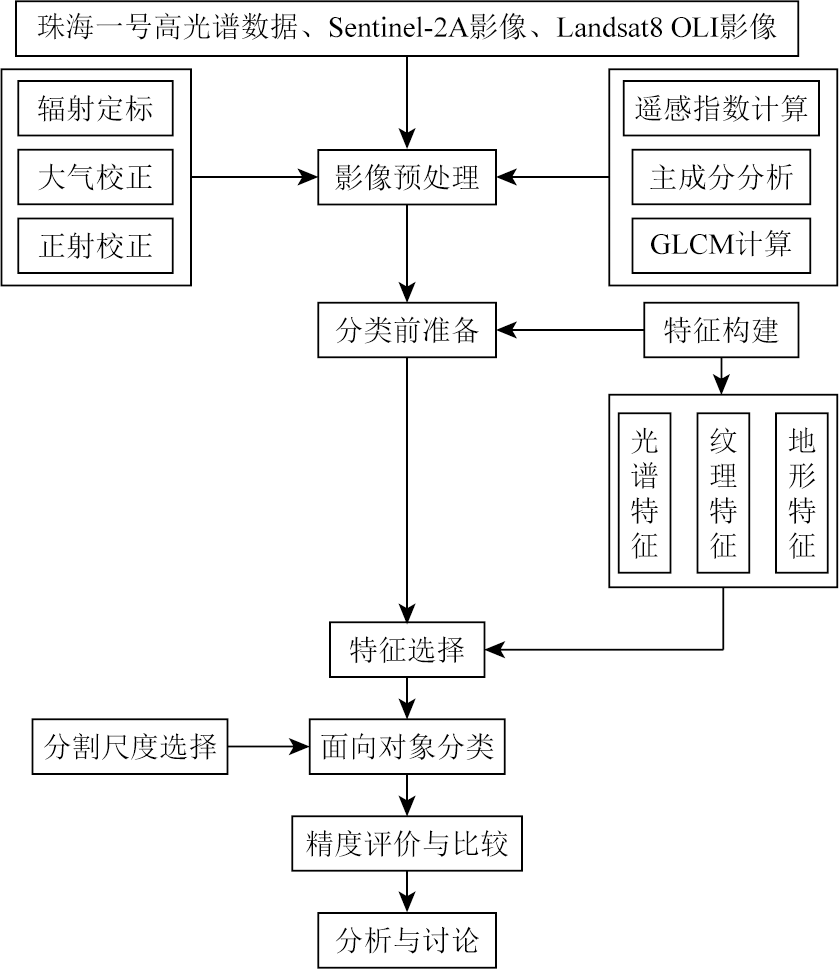
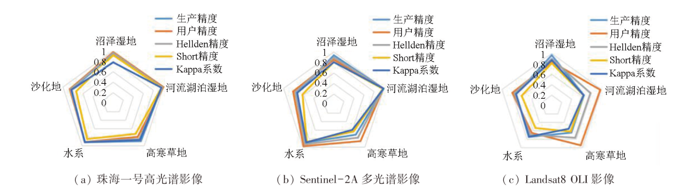
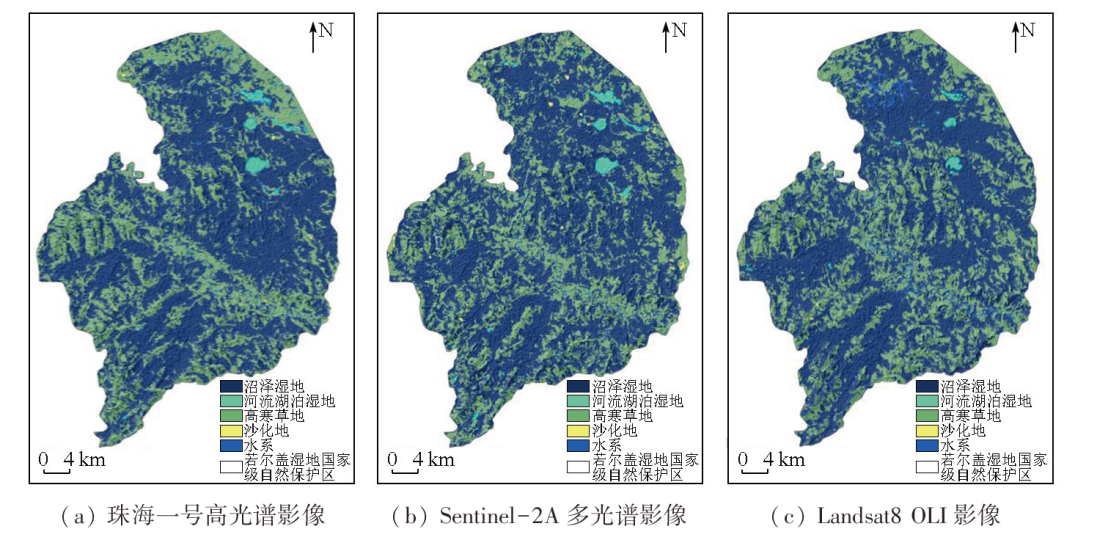
Alpine wetlands, a critical part of the natural ecosystem in the Qinghai-Tibet Plateau, serve as extremely significant water conservation and climate regulation areas in China. Accurately extracting land cover information of alpine wetlands is crucial for local ecological security monitoring and protection. This study performed object-oriented classification of the data from the Zoige wetland, including the Zhuhai-1 hyperspectral remote sensing image, Sentinel-2A remote sensing image, and Landsat-8 OLI image, integrated with spectral, textural, and topographic features. The results show that the overall data classification accuracy of the three images exceeded 85 %, with a Kappa coefficient above 68 %. The optimal classification result was observed in the Zhuhai-1 hyperspectral remote sensing image. The three images showed generally consistent data classification results, with marsh wetlands being the dominant land type. They indicated roughly the same distribution of riverine and lacustrine wetlands and slightly varying distributions of alpine grasslands, with minor area differences. Additionally, they displayed minimally different distributions of desertified land and almost the same hydrographic net distribution except for slightly different tributary distributions. This study fully explores the combinations of spectral features favorable for image classification, improving the identification accuracy of remote sensing images and providing technical support for the conservation of alpine wetlands.
表1 分类特征变量表Tab.1 Classification feature variable table |
| 特征类型 | 特征名称 | 计算方法或描述 | |
|---|---|---|---|
| 光谱特征 | 光谱波段 | 波段 | 蓝、绿、红、近红外、短波红外 |
| 光谱指数 | NDVI | NDVI = (NIR-Red) / (NIR+Red) | |
| RVI | RVI=NIR / Red | ||
| DVI | DVI=NIR-Red | ||
| MCARI | MCARI =[(NIR-Red)-0.2×(NIR-Green)]×(NIR / Red) | ||
| NDWI | NDWI=(Green-NIR) / (Green+NIR) | ||
| MNDWI | MNDWI = (Green-Mir) / (Green-Mir) | ||
| SWI | SWI = Blue+Red-NIR | ||
| 纹理特征 | 均值(Mean) | ||
| 方差(Variance) | |||
| 协同性(Homogeneity) | |||
| 对比度(Contrast) | |||
| 相异性(Dissimilarity) | |||
| 信息熵(Entropy) | |||
| 二阶矩(Second Moment) | |||
| 相关性(Correlation) | |||
| 地形特征 | 海拔 | ASTER GDEM V2数据集 | |
| 坡度 | ASTER GDEM V2数据集 | ||
| 坡向 | ASTER GDEM V2数据集 | ||
表2 地物分割参数表Tab.2 Feature segmentation parameter table |
| 分类对象 | 分割参数 | |||
|---|---|---|---|---|
| 分割尺度 | 异质性标准 | |||
| 光谱权重 | 形状标准 | |||
| 光滑度 | 紧致度 | |||
| 沼泽湿地 | 80 | 1 | 0.3 | 0.5 |
| 河流湖泊湿地 | 80 | 1 | 0.3 | 0.5 |
| 高寒草地 | 80 | 1 | 0.3 | 0.5 |
| 沙化地 | 40 | 1 | 0.3 | 0.5 |
| 水系 | 40 | 1 | 0.3 | 0.5 |
表3 珠海一号高光谱影像土地类型光谱特征值Tab.3 Spectral characteristic value of land type in Zhuhai-1 hyperspectral remote sensing image |
| 类型/光谱特征 | NIR | Red | Green | Blue | SWIR | NDVI | RVI | DVI | MCARI | NDWI | MNDWI | SWI |
|---|---|---|---|---|---|---|---|---|---|---|---|---|
| 沼泽湿地 | 1 837 | 1 043 | 1 078 | 1 146 | 1 735 | 0.21 | 1.54 | 563.81 | 823.68 | -0.20 | -0.24 | 558.41 |
| 河流湖泊湿地 | 1 677 | 4 455 | 6 977 | 4 836 | 1 164 | -0.45 | 0.38 | -2 778.75 | -603.66 | 0.61 | 0.73 | 7 238.84 |
| 高寒草地 | 2 305 | 1 471 | 1 406 | 1 425 | 2 076 | 0.22 | 1.57 | 833.77 | 793.09 | -0.24 | -0.21 | 678.85 |
| 水系 | 1 274 | 1 364 | 1 680 | 1 510 | 1 338 | -0.03 | 0.93 | -90.77 | 28.10 | 0.14 | 0.09 | 1 563.29 |
| 沙化地 | 1 922 | 1 630 | 1 741 | 1 413 | 2 181 | 0.08 | 1.18 | 291.46 | 274.52 | -0.04 | -0.08 | 1 062.31 |
表4 遥感影像面向对象分类精度验证结果Tab.4 Object-oriented classification accuracy verification results of remote sensing images |
| 遥感影像 | 总体精度/% | Kappa系数 |
|---|---|---|
| 珠海一号高光谱影像 | 93.14 | 0.83 |
| Sentinel-2A多光谱影像 | 85.95 | 0.70 |
| Landsat8 OLI影像 | 85.66 | 0.68 |
表5 影像识别土地类型面积统计Tab.5 Land type area of image recognition (km2) |
| 土地覆盖类型 | 珠海一号 高光谱影像 | Sentinel-2A 多光谱影像 | Landsat8 OLI影像 |
|---|---|---|---|
| 沼泽湿地 | 1 087.32 | 1 106.52 | 1 096.49 |
| 河流湖泊湿地 | 15.79 | 19.18 | 8.86 |
| 高寒草地 | 576.36 | 549.28 | 571.37 |
| 沙化地 | 5.93 | 11.01 | 2.27 |
| 水系 | 15.70 | 13.65 | 23.36 |
| [1] |
侯蒙京, 殷建鹏, 葛静, 等. 基于随机森林的高寒湿地地区土地覆盖遥感分类方法[J]. 农业机械学报, 2020, 51(7):220-227.
|
| [2] |
郭长庆. 基于多目标遗传算法的若尔盖高原高寒湿地生态修复优化研究[D]. 北京: 北京林业大学, 2021.
|
| [3] |
韦玮, 李增元, 谭炳香. 高光谱遥感技术在湿地研究中的应用[J]. 世界林业研究, 2010, 23(3):18-23.
|
| [4] |
庞一剑. 基于遥感技术的若尔盖高原湿地生态系统的评价及其监测[D]. 武汉: 武汉大学, 2019.
|
| [5] |
王利花. 基于遥感技术的若尔盖高原地区湿地生态系统健康评价[D]. 长春: 吉林大学, 2007.
|
| [6] |
李京, 蒋卫国. 高光谱遥感在湿地监测与分类中的应用[C]// 第十届全国光电技术学术交流会论文集, 2012:152-153.
|
| [7] |
王诗洋. 基于多时相遥感影像的辽宁双台河口湿地信息提取研究[D]. 成都: 成都理工大学, 2016.
|
| [8] |
高永攀, 陈书文. 基于遥感影像的湖泊湿地识别研究[J]. 地理空间信息, 2014, 12(5):85-86,10.
|
| [9] |
阮仁宗, 冯学智. 基于多时相遥感和GIS技术的湿地识别研究[J]. 遥感信息, 2005, 20(2):20-23,69.
|
| [10] |
张磊, 宫兆宁, 王启为, 等. Sentinel-2影像多特征优选的黄河三角洲湿地信息提取[J]. 遥感学报, 2019, 23(2):313-326.
|
| [11] |
常文涛, 王浩, 宁晓刚, 等. 融合Sentinel-2红边波段和Sentinel-1雷达波段影像的扎龙湿地信息提取[J]. 湿地科学, 2020, 18(1):10-19.
|
| [12] |
乔雯钰. 基于高光谱遥感影像的黄河入海口湿地分类方法研究[D]. 青岛: 山东科技大学, 2020.
|
| [13] |
姚杰鹏, 杨磊库, 陈探, 等. 基于Sentinel-1,2和Landsat8时序影像的鄱阳湖湿地连续变化监测研究[J]. 遥感技术与应用, 2021, 36(4):760-776.
|
| [14] |
张晓斌, 石佳, 欧明武, 等. 基于Landsat8遥感数据的东洞庭湖湿地变化监测与分析[J]. 上海国土资源, 2021, 42(1):24-28.
|
| [15] |
于新菊. 图谱耦合的高分辨率城市精细不透水面提取方法研究[D]. 北京: 中国科学院大学(中国科学院遥感与数字地球研究所), 2016.
|
| [16] |
左丹丹, 罗鹏, 杨浩, 等. 保护地空间邻近效应和保护成效评估——以若尔盖湿地国家级自然保护区为例[J]. 应用与环境生物学报, 2019, 25(4):854-861.
|
| [17] |
费世民, 崔丽娟, 何亚平, 等. 若尔盖高寒湿地生态系统定位站的背景研究——若尔盖高寒湿地研究概述[J]. 四川林业科技, 2006, 27(2):21-29.
|
| [18] |
武高洁, 林海晏, 宁宇, 等. 近12年若尔盖自然保护区各功能区景观格局动态分析[J]. 西部林业科学, 2017, 46(5):6-12.
|
| [19] |
张振勇, 王萍, 朱鲁, 等. eCognition技术在高分辨率遥感影像信息提取中的应用[J]. 国土资源信息化, 2007(2):15-17,33.
|
| [20] |
郭霞. 基于Landsat8 OLI遥感数据的随机森林分类优化研究[D]. 秦皇岛: 燕山大学, 2021.
|
| [21] |
郑淑丹, 郑江华, 石明辉, 等. 基于分形和灰度共生矩阵纹理特征的种植型药用植物遥感分类[J]. 遥感学报, 2014, 18(4):868-886.
|
| [22] |
陈云浩, 冯通, 史培军, 等. 基于面向对象和规则的遥感影像分类研究[J]. 武汉大学学报(信息科学版), 2006, 31(4):316-320.
|
/
| 〈 |
|
〉 |
