
面向条带状航测区域的无人机曲线航线设计方法探索
|
孙鑫超(2000-),男,硕士研究生,主要从事无人机摄影测量与遥感研究。Email: sxc123@my.swjtu.edu.cn。 |
Copy editor: 陈昊旻
收稿日期: 2023-09-22
修回日期: 2023-12-31
网络出版日期: 2026-06-03
基金资助
四川省科技厅重点研发计划项目“国土空间规划三维智能管控关键技术研究与示范应用”(2022YFS0449)
Exploration of curved UAV flight path design methods for banded aerial survey areas
Received date: 2023-09-22
Revised date: 2023-12-31
Online published: 2026-06-03
孙鑫超 , 骆奇峰 , 何宗友 , 张奥丽 , 蔡国林 . 面向条带状航测区域的无人机曲线航线设计方法探索[J]. 自然资源遥感, 2025 , 37(1) : 68 -75 . DOI: 10.6046/zrzyyg.2023291
To improve the efficiency of UAV aerial surveys in complex banded areas, this study explored and proposed a design method for curved flight paths. This method included planning algorithms for both horizontal and variable-altitude curved flight paths for banded areas, as well as a detection algorithm for flight path safety based on a digital elevation model (DEM). First, a simulation system for UAV aerial surveys was constructed, and the method was tested for planar aerial surveys, variable altitude aerial surveys, and safety detection through simulation experiments. Then, the quality of the aerial photography production data was verified using actual aerial photography experiments. The results indicate that design algorithms for horizontal and variable-altitude flight paths can automatically generate reasonable flight paths for complex banded areas and that the detection algorithm for flight path safety can ensure route safety. Compared to conventional flight paths, the quality of aerial photography data from curved flight paths can also meet the requirements of existing regulations. In other words, for aerial surveys in complex banded areas, the method presented in this study allows for the automatic design of reasonable, safe flight paths and, thus, can effectively improve the operational efficiency of UAV aerial photography.
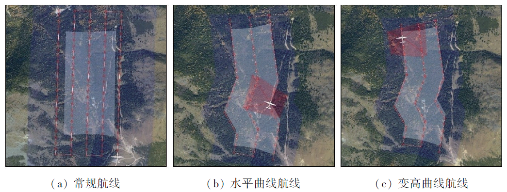
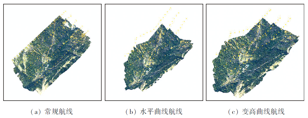
图6 不同航线单镜头航拍仿真Fig.6 Simulation of single lens aerial photography of different routes |
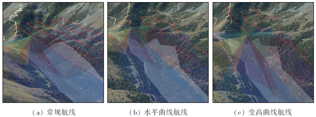
图7 不同航线五镜头倾斜航摄仿真Fig.7 Simulation of five-shot tilt aerial photography of different routes |
表1 生成不同航线参数Tab.1 Generating different route parameters |
| 镜头 | 航线类型 | 航程/m | 影像数量/张 |
|---|---|---|---|
| 单镜头 | 常规航线 | 6 452.60 | 130 |
| 水平曲线航线 | 3 062.15 | 70 | |
| 变高曲线航线 | 3 153.34 | 70 | |
| 五镜头 | 常规航线 | 6 453.30 | 650 |
| 水平曲线航线 | 3 062.10 | 350 | |
| 变高曲线航线 | 3 151.50 | 350 |
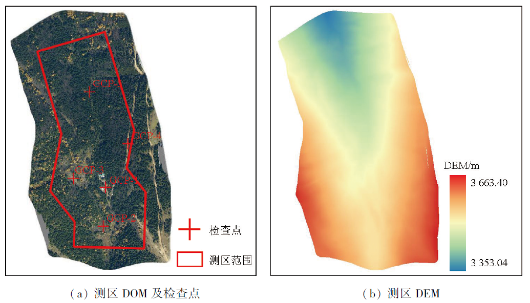
表2 不同航线DOM数据检查点误差Tab.2 Error of DOM data control points of different routes (m) |
| 检查点 | 常规航线 | 水平曲线航线 | 变高曲线航线 | |||
|---|---|---|---|---|---|---|
| △x | △y | △x | △y | △x | △y | |
| GCP-1 | -0.002 1 | 0.001 3 | 0.001 2 | -0.003 0 | 0.001 8 | 0.000 0 |
| GCP-2 | -0.002 2 | 0.001 8 | -0.004 2 | 0.001 5 | 0.004 3 | -0.002 2 |
| GCP-3 | 0.004 2 | 0.003 9 | 0.004 1 | 0.002 4 | 0.005 2 | 0.003 8 |
| GCP-4 | 0.005 9 | 0.001 8 | -0.004 4 | -0.004 4 | 0.003 4 | 0.003 6 |
| GCP-5 | -0.002 3 | -0.001 8 | 0.001 9 | 0.003 3 | -0.002 1 | 0.001 6 |
表3 不同航线DEM数据误差对比Tab.3 Error comparison of DEM data of different routes (m) |
| 航线类型 | DEM平均误差 | DEM中误差 |
|---|---|---|
| 常规航线 | 0.465 9 | 0.711 6 |
| 水平曲线航线 | 0.486 5 | 0.717 0 |
| 变高曲线航线 | 0.326 4 | 0.422 7 |
| [1] |
毕凯, 李英成, 丁晓波, 等. 轻小型无人机航摄技术现状及发展趋势[J]. 测绘通报, 2015(3):27-31,48.
|
| [2] |
|
| [3] |
顾广杰, 张坤鹏, 刘志超, 等. 浅谈无人机倾斜摄影测量技术标准[J]. 测绘通报, 2017(s1):210-213.
|
| [4] |
于广瑞, 王欣滔, 黄兴明. 无人机测绘任务方案设计与应用[J]. 测绘通报, 2017(s1):216-219.
|
| [5] |
|
| [6] |
盛辉, 李凌昊, 刘树生, 等. 面向城市复杂区域的无人机倾斜摄影航线规划方法[J]. 测绘通报, 2021(1):47-52.
|
| [7] |
毕瑞, 甘淑, 袁希平, 等. 不同地形环境下无人机航线规划及三维建模分析[J]. 测绘通报, 2022(4):83-89,129.
|
| [8] |
魏铼, 胡卓玮, 陈天博, 等. 单机倾斜摄影方式的无人机航线设计[J]. 测绘科学, 2018, 43(6):147-155.
|
| [9] |
王炳乾, 陈超, 王华军, 等. 基于等高线构建无人机航线的新型仿地飞行策略[J]. 测绘通报, 2020(11):104-107,115.
|
| [10] |
李天烁, 邓非, 万方. 实景三维模型辅助下小型多旋翼无人机航线设计[J]. 遥感信息, 2017, 32(1):40-43.
|
| [11] |
|
| [12] |
徐博, 陈立平, 谭彧, 等. 基于无人机航向的不规则区域作业航线规划算法与验证[J]. 农业工程学报, 2015, 31(23):173-178.
|
| [13] |
李秀丽. 基于Google地图数据的可视化无人机航线规划研究[J]. 测绘通报, 2014(1):74-76.
|
/
| 〈 |
|
〉 |