
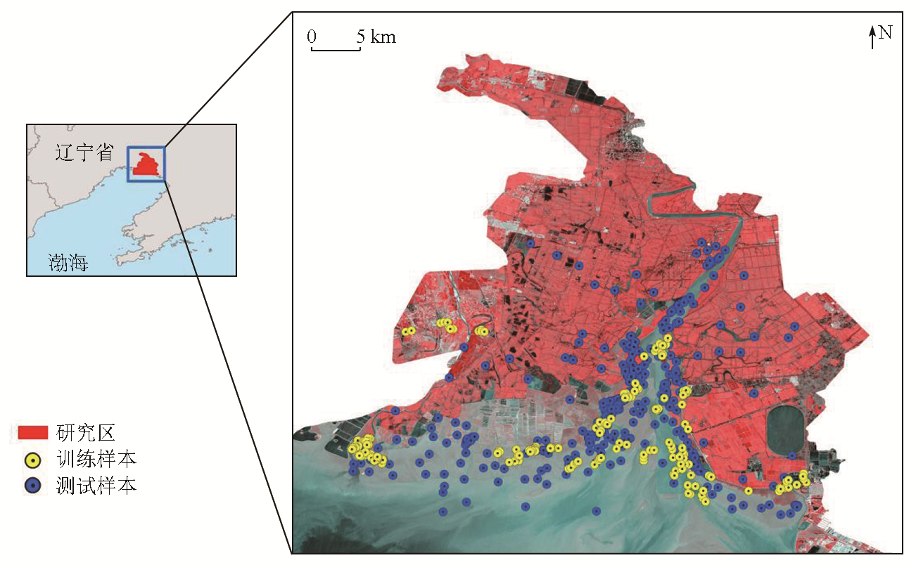
辽河口盐地碱蓬时空动态遥感监测及其识别机理研究
|
李钰彬(1999-),男,硕士研究生,研究方向为滨海湿地遥感。Email: 18636183172@163.com。 |
Copy editor: 陈昊旻
收稿日期: 2023-09-22
修回日期: 2024-03-11
网络出版日期: 2026-06-03
基金资助
国家重点研发计划青年科学家项目“地上植被生物量广域精细多模观测技术与装备”(2022YFF1302000)
国家自然科学基金青年基金项目“基于样本扩增方法与多源卫星影像的无瓣海桑扩散进程监测方法研究”(42201422)
“基于Sentinel光学和雷达遥感影像的泥炭沼泽识别方法研究”(42101399)
第五批吉林省青年科技人才托举工程“泥炭沼泽的信息提取研究”(QT202101)
Remote sensing-based monitoring and identification mechanisms of the spatiotemporal dynamics of Suaeda salsa in the Liaohe estuary, China
Received date: 2023-09-22
Revised date: 2024-03-11
Online published: 2026-06-03
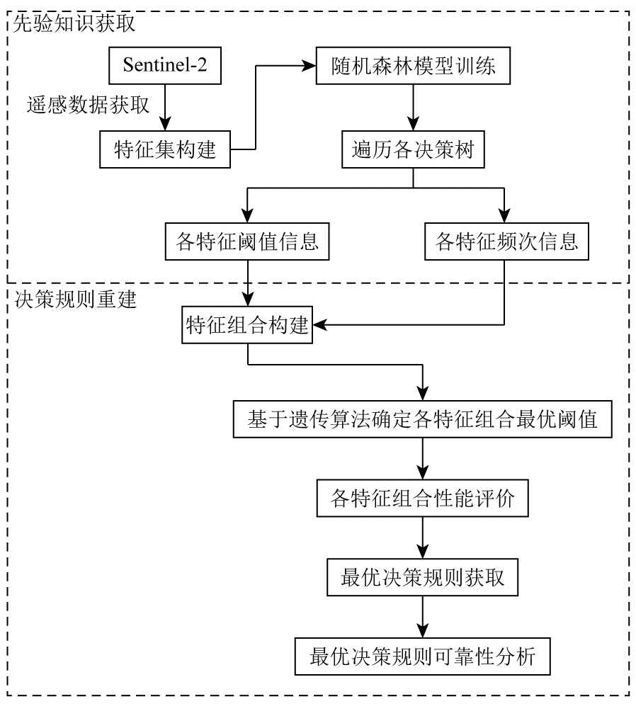
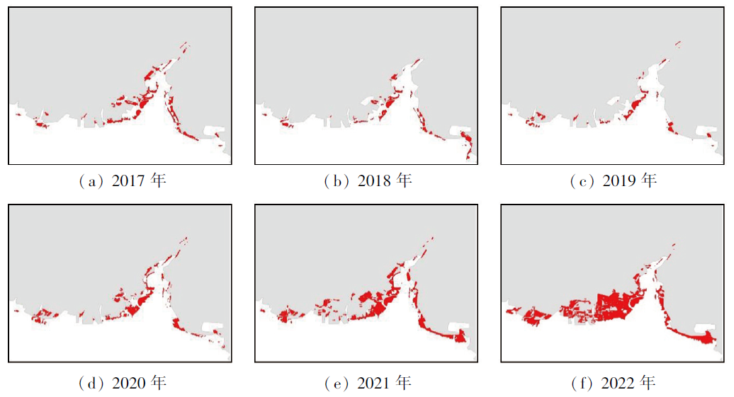
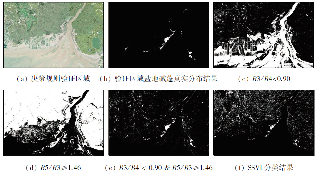
作为全球面积最大的红海滩景观,监测辽河口盐地碱蓬的时空动态变化对揭示其“退养还湿”等保护措施成效具有重要意义。目前,卫星遥感技术已广泛应用于包括盐地碱蓬在内的滨海植被识别与制图,但现有分类方法依赖于难以解释的黑箱模型,忽视了对识别机理的探究,制约了相关方法的改进和发展。可解释人工智能的发展为黑箱算法的解析指出了新的方向。考虑到构成随机森林的决策规则具有可解释性,本研究构建了一套从已训练随机森林模型中抽取最优决策规则的新方法,最终重构得到识别盐地碱蓬的最优决策规则,即B3/B4<0.90且B5/B3≥1.46,数据整体精度优于90%; 以2017—2022年的Sentinel-2影像为数据源,实现了对辽河口盐地碱蓬的逐年动态提取,并结合质心迁移法,分析了“退养还湿”工程实施后盐地碱蓬时空变化,揭示了该区域盐地碱蓬呈现快速恢复的现状。
李钰彬 , 王宗明 , 赵传朋 , 贾明明 , 任春颖 , 毛德华 , 于皓 . 辽河口盐地碱蓬时空动态遥感监测及其识别机理研究[J]. 自然资源遥感, 2025 , 37(1) : 195 -203 . DOI: 10.6046/zrzyyg.2023293
The Liaohe estuary of China boasts the largest red beach landscape in the world. Monitoring the spatiotemporal dynamics of Suaeda salsa in this region is of great significance for revealing the performance of conservation measures such as returning aquaculture to wetlands. Currently, satellite remote sensing technology has been widely applied to the mapping and identification of coastal vegetation including Suaeda salsa. However, existing classification methods rely on black-box models, which are difficult to interpret, while overlooking exploring identification mechanisms. This has hindered the improvement and development of related methods. Fortunately, the advancement in explainable artificial intelligence (XAI) has provided new directions for analyzing the black-box models. Considering that the decision rules in random forests are interpretable, this study developed a new method to extract the optimal decision rules from trained random forest models. Using this method, this study ultimately reconstructed the optimal decision rules used to identify Suaeda salsa, i.e., B3/B4<0.90 & B5/B3≥1.46, with an overall data accuracy exceeding 90%. Using annual Sentinel-2 images from 2017 to 2022 as a data source, the study successfully extracted the annual dynamics of Suaeda salsa in the Liaohe Estuary. Accordingly, by combining the centroid migration method, this study analyzed the spatiotemporal changes in the Suaeda salsa following the implementation of returning aquaculture to wetlands, revealing the current status that the Suaeda salsa in this region is undergoing rapid restoration.
表1 选中的2017—2022年卫星影像Tab.1 Selected satellite images during 2017 and 2022 |
| 时间 | 产品类型 | 云量/% |
|---|---|---|
| 2017-09-29 | Level-1C | 0 |
| 2018-09-04 | Level-1C | 1.08 |
| 2019-09-14 | Level-2A | 0.51 |
| 2020-09-18 | Level-2A | 0.01 |
| 2021-09-23 | Level-2A | 0 |
| 2022-09-18 | Level-2A | 0 |
表2 Sentinel-2影像特征介绍Tab.2 Features derived from the Sentinel-2 Images |
| 特征类型 | 特征 | |
|---|---|---|
| 光谱 特征 | B2,B3,B4,B5,B6,B7,B8,B8A,B11,B12,VV,VH | |
| 波段比 值特征 组 | B2/B4,B3/B4,B3/B8,B4/B2,B4/B3,B4/B5,B4/B8,B5/B3,B5/B4,B6/B3,B6/B5,B7/B3,B7/B4,B8/B2,B8/B3,B8/B4,B8/B5,B8/B11,B8/B12,B8A/B5,B11/B8,B11/B12,B12/B4,B12/B8,B12/B11,VV/VH,VH/VV | |
| 指数特 征组① | 归一化植被指数(normalized difference vegetation index, NDVI) | |
| 增强植被指数(enhanced vegetation index, EVI) | ||
| 植被衰减指数(plant senescence reflectance index, PSRI) | ||
| 归一化差异红色变异指数(normalized difference red edge, NDRE) | ||
| 地表水分指数(land surface water index, LSWI) | ||
| 归一化水分指数(normalized difference water index, NDWI) | ||
| 修正的归一化差异水体指数(modified normalized difference water index, mNDWI) | ||
| 植被近红外反射指数(near-infrared reflectance of vegetation, NIRv) | ||
①SWIR表示B11和B12这2个波段; RE表示B5, B6, B7, B8A这4个波段。 |
表3 混淆矩阵与精度分析Tab.3 Classification confusion matrix and precision analysis |
| 类别 | 碱蓬 | 非碱蓬 |
|---|---|---|
| 碱蓬 | 199 | 23 |
| 非碱蓬 | 1 | 177 |
| UA/% | 89.6 | 99.4 |
| PA/% | 99.5 | 89.0 |
| OA/% | 94.0 | |
表4 不同年份对应决策规则的分类精度结果Tab.4 Classification accuracy results of decision rules in different years |
| 时间 | 阈值信息 | OA/% |
|---|---|---|
| 2017-09-29 | B3/B4<0.98 & B5/B3≥1.16 | 86.0 |
| 2018-09-04 | B3/B4<1.0 & B5/B3≥1.20 | 92.5 |
| 2020-09-18 | B3/B4<0.88 & B5/B3≥1.46 | 96.8 |
| 2021-09-23 | B3/B4<0.83 & B5/B3≥1.46 | 97.3 |
| 2022-09-18 | B3/B4<0.96 & B5/B3≥1.26 | 98.5 |
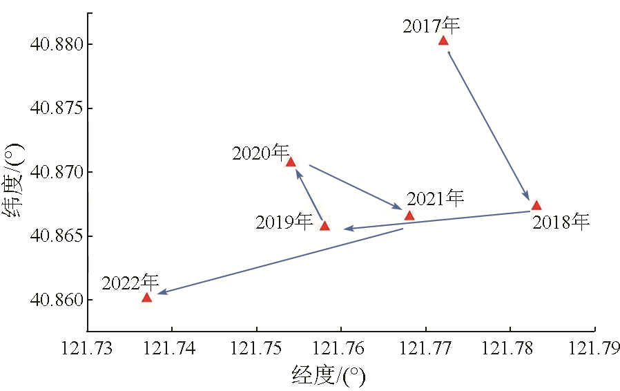
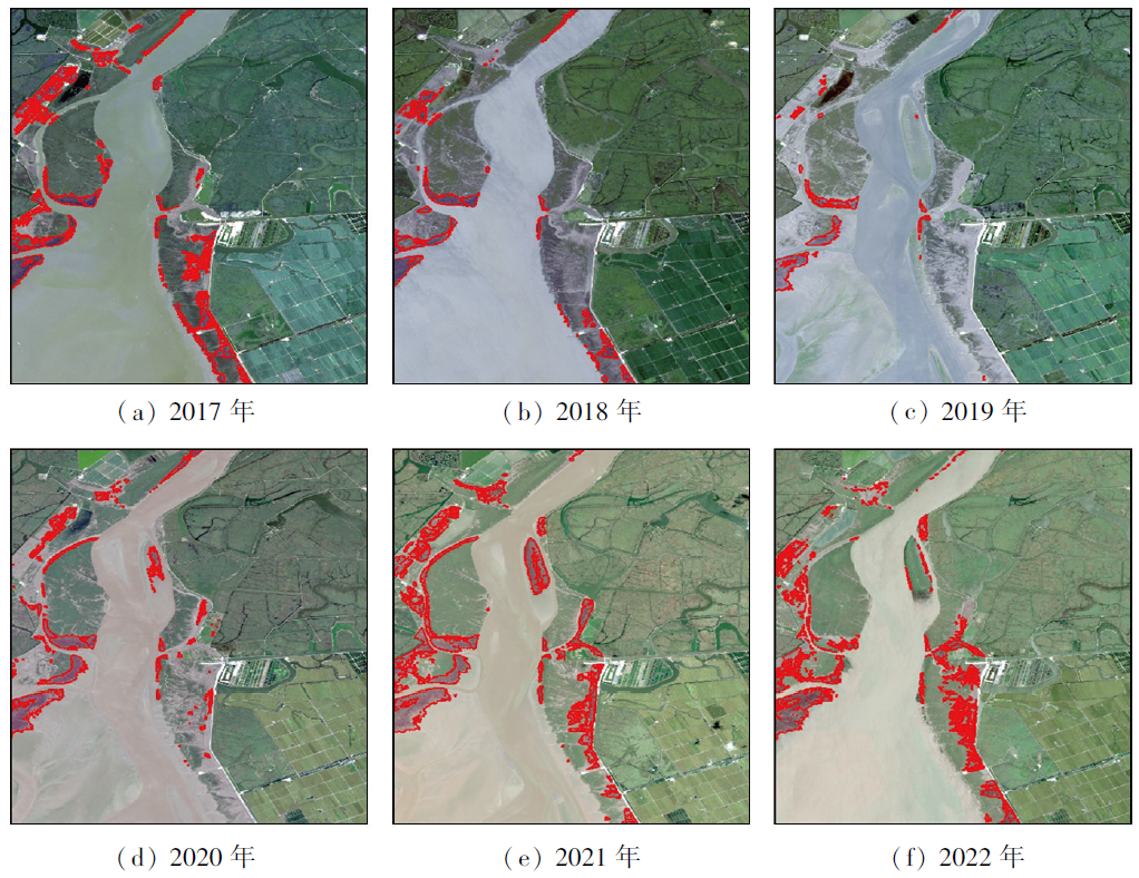
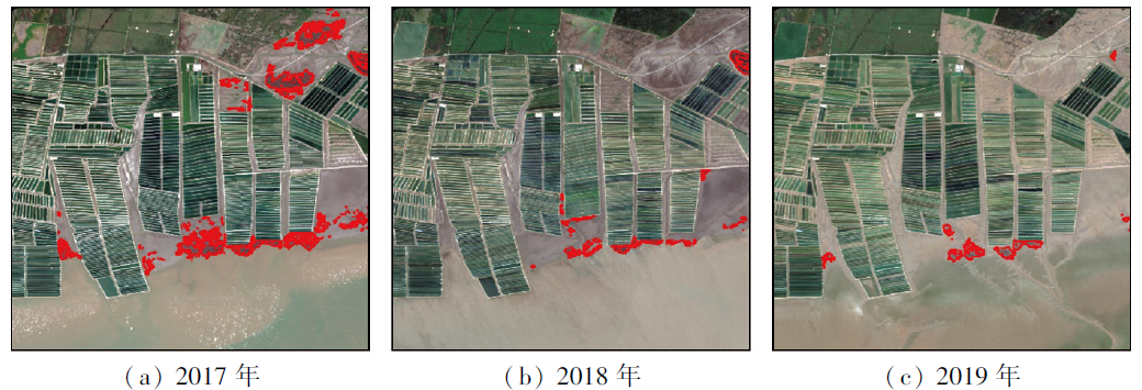
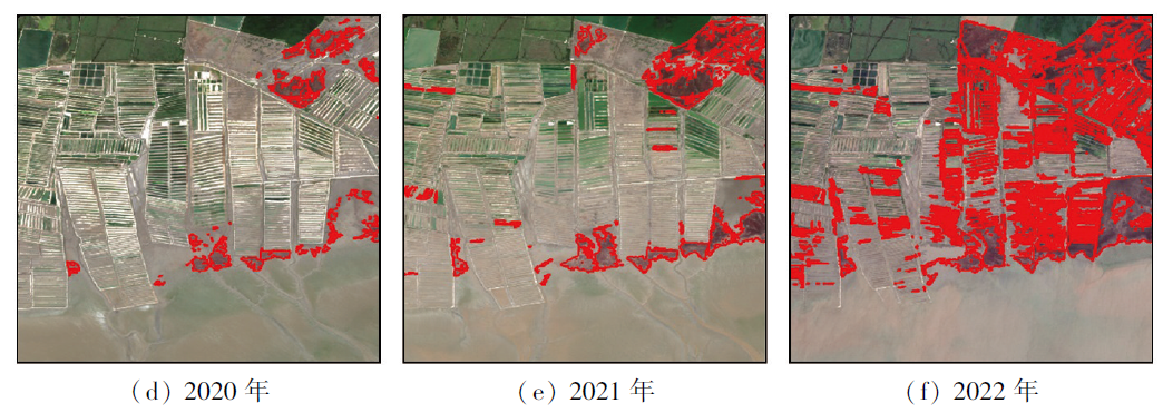
图3 2017—2022年辽河口盐地碱蓬时空变化Fig.3 Temporal and spatial distribution changes of Suaeda Salsa in Liaohe estuary from 2017 to 2022 |
表5 2017—2022年辽河口盐地盐地碱蓬面积Tab.5 Area information of Suaeda salsa in Liaohe estuary from 2017 to 2022 (hm2) |
| 年份 | 2017年 | 2018年 | 2019年 | 2020年 | 2021年 | 2022年 |
|---|---|---|---|---|---|---|
| 面积 | 1 154.69 | 732.43 | 658.15 | 1 380.20 | 3 048.38 | 4 221.75 |
表6 SSVI提取盐地碱蓬结果的混淆矩阵Tab.6 Confusion matrix of extraction results of Suaeda Salsa using SSVI |
| 类别 | 碱蓬 | 非碱蓬 |
|---|---|---|
| 碱蓬 | 139 | 5 |
| 非碱蓬 | 61 | 195 |
| UA/% | 96.5 | 75.9 |
| PA/% | 69.5 | 97.5 |
| OA/% | 83.3 | |
表7 2017—2022年SSVI提取盐地碱蓬的阈值与精度Tab.7 Threshold and accuracy of SSVI extraction Suaeda Salsa from 2017 to 2022 |
| 时间 | 阈值信息 | OA/% |
|---|---|---|
| 2017-09-20 | SSVI > 4 | 73.0 |
| 2018-09-27 | SSVI > 0.3 | 84.0 |
| 2020-09-30 | SSVI > 1 | 71.5 |
| 2021-09-01 | SSVI > 3 | 66.8 |
| 2022-09-01 | SSVI > 5 | 79.5 |
| [1] |
温广玥. 1997—2018年辽河口翅碱蓬生物群落时空变化特征研究[D]. 北京: 中国地质大学(北京), 2020.
|
| [2] |
|
| [3] |
王旖旎, 康亚茹, 陈旭, 等. 辽河口潮滩湿地景观格局空间演变的动态分析[J]. 大连海洋大学学报, 2021, 36(6):1009-1017.
|
| [4] |
|
| [5] |
邵璐, 姜华. 辽宁碱蓬根际土壤真菌多样性的季节变化及其耐盐性[J]. 生态学报, 2016, 36(4):1050-1057.
|
| [6] |
余雪洋, 叶思源,
|
| [7] |
何爽, 张森, 田家, 等. 结合多模态数据的滨海湿地碱蓬叶面积指数无人机高光谱反演[J]. 遥感学报, 2023, 27(6):1441-1453.
|
| [8] |
张树文, 颜凤芹, 于灵雪, 等. 湿地遥感研究进展[J]. 地理科学, 2013, 33(11):1406-1412.
|
| [9] |
彭剑伟. 1986—2018年辽河口滨海湿地连续变化时空格局及驱动力分析[D]. 长沙: 中南林业科技大学, 2021.
|
| [10] |
|
| [11] |
王文硕. 典型盐生植被群落演替退化遥感监测研究[D]. 大连: 大连海洋大学, 2022.
|
| [12] |
许晨, 卢霞, 桑瑜, 等. 基于空谱融合与AlexNet算法的滨海湿地植被分类研究[J]. 海洋科学, 2023, 47(7):1-11.
|
| [13] |
|
| [14] |
|
| [15] |
|
| [16] |
李营, 陈云浩, 陈辉, 等. GF-1 WFV影像的翅碱蓬植被指数构建[J]. 武汉大学学报(信息科学版), 2019, 44(12):1823-1831.
|
| [17] |
|
| [18] |
|
| [19] |
|
| [20] |
|
| [21] |
|
| [22] |
程丽娜, 钟才荣, 李晓燕, 等. Sentinel-2密集时间序列数据和Google Earth Engine的潮间带湿地快速自动分类[J]. 遥感学报, 2022, 26(2):348-357.
|
| [23] |
|
| [24] |
张猛, 曾永年. 长株潭城市群湿地景观时空动态变化及驱动力分析[J]. 农业工程学报, 2018, 34(1):241-249.
|
| [25] |
黄子强. 鸻鹬类迁徙停歇期对翅碱蓬和潮间带湿地的栖息地利用[D]. 沈阳: 辽宁大学, 2019.
|
| [26] |
|
/
| 〈 |
|
〉 |