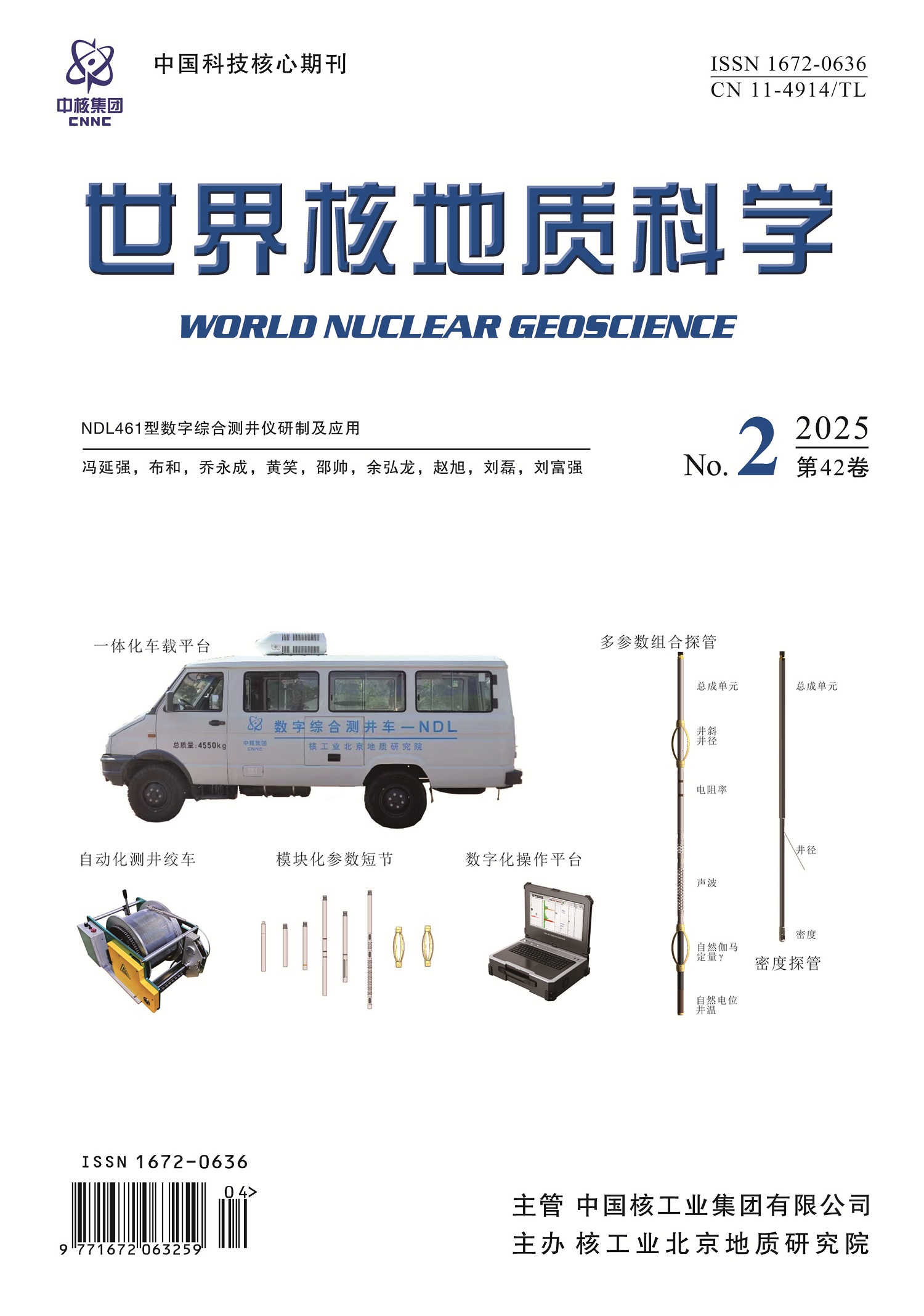
With the rapid development of sandstone-type uranium exploration in China, the workload of production logging has been increasing year by year. Simultaneously, with breakthroughs in the exploration of the “second prospecting space”,the logging depth is gradually increasing to 1 000 meters. The existing logging equipment requires 2-3 downhole operations to complete uranium geophysical logging,resulting in long logging times and risks such as borehole collapse and pipe sticking. By developing a modular multi-parameter downhole sub,we have addressed the issues of mutual constraints and interference among electrical,acoustic,and radioactive parameters in logging applications. This has led to the creation of a flexible downhole probe that can be combined according to actual application needs. We have also developed an integrated ground control platform and accompanying logging data acquisition and processing software, forming a highly integrated, noise-resistant, and fast-responding digital control system. This has culminated in the development of the new-generation NDL461 digital integrated logging tool. This logging tool has passed third-party verification and has been field-tested in the Songliao,Qaidam,Yili,and Tarim basins,demonstrating its stability,accuracy,and applicability. The developed logging tool provides technical equipment support for China’s fourth-generation uranium exploration technology system.
Qaidam basin,located at the northeastern margin of the Qinghai-Tibet Plateau,is one of China’s major large-scale oil- and gas-bearing basins. The results of uranium exploration in recent years show that it has good prospects of uranium mineralization. However,compared to the western Qaidam basin,research on the fundamental geology and uranium exploration in the eastern Qaidam basin remains relatively underdeveloped. Based on systematic summary of low-temperature thermochronological data,provenance and growth strata characteristics,the Cenozoic tectonic evolution history of the east Qaidam area was reviewed. We investigated the control of Cenozoic structural evolution on uranium mineralization in the eastern Qaidam,through comprehensive analysis of typical uranium occurrences surface (field observations) and near-surface (seismic profiles) data. The results indicated that fault systems exert primary control over uranium mineralization,with uranium occurrences predominantly distributed within the flank of gentle anticlinal near the thrust faults,and the Olongbulak North Fault and its secondary faults may work as the principal ore-controlling faults. The uranium mineralization in the east Qaidam occurs predominantly by exudative uranium metallogeny,with Carboniferous hydrocarbon source rocks potentially serving as significant provider of abundant uranium for the mineralization processes. The fault systems within the basin provide effective channels and driving force for the upward migration of deep uranium-rich reduction fluid,and the regional intense compression and hydrocarbon generation control the spatial position of uranium mineralization. The findings in this paper are meaningful for the following uranium exploration work in the east Qaidam basin.
This study focuses on the rare uranium mineralization phenomenon discovered in the Tamsu uranium deposit of Yin’e basin that part of uranium ores contain a large amount of apatite. The lithology,mineralogy,and geochemistry of these uranium ores were studied in detail by microscope,SEM,EMPA,XRD and analysis of major and trace elements,strontium isotope and bulk rock U-Pb isotope,its genesis was also discussed. The rock types associated with phosphorus-rich uranium ores include purplish-red dolomitic phosphorite,grayish-white dolomitic phosphorite,phosphorus-bearing siltstone,medium phosphatic sandstone,and brecciated limestone. The whole rock P2O5 content of the samples ranges from 0.42 % to 27.74 %. The primary phosphorus-containing mineral is apatite which occurs as microcrystalline apatite (about 0.5 μm) aggregate and accounts for up to 70 % of the whole rock. These apatite were identified as carbonate-fluorapatite. Uranium content varies from 221×10-6 to 3 486×10-6 and show a significant positive correlation with P2O5 content,the rock’s water bursting breccia structure,REE patterns, and lower Sr isotope values indicated the participation of hydrothermal deposition during apatite formation. Whole rock U-Pb isochron age of purplish-red phosphorite is 54±5.2 Ma,implying that the phosphorite suffered the alteration by the interlayer oxidation derived from the Zongnaishan uplift event around 60 Ma. In summary, the formation of phosphorus-rich uranium ores in the Tamsu area was the product of multiple geological processes including hydrothermal deposition and interlayer oxidation
Xiangshan ore field is the largest volcanic-hosted uranium ore field in China. Continuous discoveries of lead,zinc,silver,and copper polymetallic mineralization at depth beneath uranium mineralization reveal a spatial distribution pattern of “upper uranium-lower polymetallic”mineralization. Therefore,the genetic relationship between polymetallic mineralization and large-scale uranium mineralization has become another research focus in the Xiangshan ore field. This study systematically investigated the H-O-S-Pb isotopic compositions and conducted comprehensive comparative analyses of uranium and polymetallic mineralization. Results indicate that uranium mineralization involved more atmospheric precipitation and crustal-derived materials compared to polymetallic mineralization. The sulfur isotopic composition of polymetallic mineralization in the Xiangshan area shows distinct differences from typical regional polymetallic deposits. At least one stage of relatively uranium-enriched mineralization process has been identified during the polymetallic mineralization in Xiangshan region.
In the Xiaguxuan area of the eastern QFⅤ ore belt in the Lujing uranium ore-field,siliceous vein type uranium mineralization occurs. The ore-bearing rock is medium-coarse-grained porphyritic biotite granite. The hydrothermal alteration near the ore mainly includes hematitization,silicification,chloritization and carbonatization. Zircon U-Pb chronology,petrography and petrogeochemical analysis show that the zircon U-Pb concordant age of the uranium-bearing fresh granite is 228.3 Ma and the weighted average age is 228.9 Ma,which was formed in the second stage of the Indosinian period (Late Triassic). The major elements are characterized by high potassium calc-alkaline series and weakly peraluminous granite,with high contents of silicon and titanium,low contents of magnesium and iron,slightly low aluminum,rich in alkalis and potassium and low in sodium. Among the trace elements,Ba,Sr and Ti are depleted, while Rb,Th,Pb and Nd are enriched. The rare earth distribution curve is of light rare earth enrichment type with right inclination,and there is obvious fractionation between light and heavy rare earth elements,with obvious negative Eu anomaly,which is consistent with the geochemical characteristics of S-type granite. It is considered through analysis that the ore-hosting granite in the Xiaguxuan area may be the product formed by the partial melting of the aluminous shallow metamorphic rock series in the upper crust due to decompression and temperature increase under the background of the transition from compression to extension in the Late Triassic. Compared with normal granite,the ore-bearing granite has a higher SiO2 content, a multiple increase in the contents of CaO and P2O5,as well as the ratios of Fe2O3/FeO and HREE/LREE,and high contents of U and P,etc. All these indicate that the aggregation and precipitation of U in the study area are closely related to the chemical activities of P,LREE and HREE. These summarized chemical indexes are useful indicators for searching for siliceous vein type uranium mineralization in the inner zone of the granite body.
The Rössing mine in Namibia is the earliest alaskite-type uranium mine,ranking the top 10 globe uranium mines. However,the backup resources are seriously insufficient,therefore it is urgent to carry out exploration to expand resources and ensure the sustainable development of the mine. Based on the secondary data development,the authors carried out field geological survey,large-scale geological mapping,and ground energy spectrum measurement on the main uranium deposits in the mining area,studied the typical uranium deposit and identified uranium mineralization characteristics and ore-controlling factors. It was considered that the alaskite-type uranium deposit was the products of regional tectonic-magmatic evolution,which was crystallized from granitic magma. The ore-forming material was derived from the anatexis of the ancient basement rocks. The diversity of source rocks and the heterogeneity of melting resulted in the capacity variations in the ore-bearing alaskite. The localization of the deposit is controlled by NNE-trending regional faults, dome (fold) turning ends and structural variation sites. Ore-bearing pluton intruded along the structural and weak stratigraphic planes,with post-mineralization hydrothermal alteration and supergene leaching and enrichment.On the basis of summarizing the geological background, metallogenic and ore-controlling pattern of uranium mineralization,this paper defined the prediction factors of uranium mineralization and extracted the prediction factors including uranium deposits buffer zones,alaskite distribution areas,regional tectonic buffer zones,marble exocontact zones,alteration development zones, aerial radiometric uranium anomaly zones and ground gamma spectrometry anomaly zones. Using the comprehensive information geological unit method,uranium metallogenic prediction was conducted and 14 new uranium prospective sectors were delineated in the Rössing mining licence area with approximately 140 000 tons potential resources. This achievement indicated significant uranium potential in the periphery of the Rössing deposit and worthy more exploration efforts. The 5 predicted level-A prospects are the focus for the next exploration. Among which,the A1(Z17-19)sector has been verified as a super-large uranium deposit through drilling,demonstrating remarkable prospecting achievements.
More than 60 years of uranium exploration has accumulated a lot of knowledge. Traditional technical means and management measures can hardly meet the business development needs of the information age. The knowledge service and information management model in the field of uranium exploration urgently needs to be upgraded. This paper focuses on the building of an integrated knowledge platform for collecting, managing and analyzing various types of information related to uranium deposit,especially the key process of the construction of uranium exploration knowledge base and its application in the field of uranium geological exploration. The content of the knowledge base was enriched by two ways of manual upload and automatic acquisition and import. After launch, the repository will be prompted in all the member units of the CNNC so to realize the knowledge preservation, management and application in the scientific and effective sharing way, and transformation of knowledge and information management model in uranium exploration field.
Excessively high acquisition cost is one of the main factors restricting the large-scale application of seismic exploration methods in geophysical prospecting of sandstone-type uranium deposits. Compressed sensing theory can achieve low-cost seismic data acquisition through compressed measurement and sparse reconstruction, thereby improving the economic benefits of seismic exploration methods for sandstone-type uranium deposits. In practical operations, the design of the measurement matrix in compressed sensing theory, that is, the quality of the subsampling method, is one of the keys to the success or failure of seismic data reconstruction. In this paper, the improved piecewise random subsampling method is combined with the edge-preserving piecewise random subsampling method,and an optimized edge-preserving piecewise random subsampling method is proposed. Through the Gram matrix analysis under different decimation ratio parameter conditions, forward-modeling data comparison and the real seismic data application of sandstone-type uranium deposits in the Songliao basin, it is shown that the optimized subsampling method proposed in this study has the best comprehensive performance and can be used as an effective method for random subsampling in seismic exploration of sandstone-type uranium deposits, which can provide a good data basis for subsequent sparse recovery.
The Beishan high-level radioactive waste disposal pit in China is planned to be excavated by a small-diameter blind shaft boring machine,and the gage cutter is the key component of the boring machine to control the accuracy of the hole and the most vulnerable to loss. Its reasonable design and layout are the premise to realize the efficient excavation of the high-level radioactive waste disposal pit. In this paper,the linear cutting test of gage cutter is carried out for Beishan granite by using 11 inch round edge cutter preselected by small diameter blind shaft boring machine. The rock breaking process and vibration characteristics of gage cutter under different penetration depth and installation angle are analyzed. The test results show that under the same penetration depth,the average normal force of the 20° installation angle cutter is generally larger,the lateral force is smaller,but the average rolling force of the two cutters are closer. Under the same penetration depth,the average peak value of triaxial vibration acceleration of gage cutters with different installation angles is the largest in the lateral vibration acceleration,followed by the normal vibration acceleration and the tangential vibration acceleration. The larger the installation angle,the greater the difference in the triaxial vibration acceleration of the gage cutters,the greater the lateral vibration intensity,and the higher the frequency of the lateral high-amplitude vibration.With the increase of penetration depth,the triaxial vibration acceleration of the gage cutter increases,and the frequency of strong vibration in the rock breaking of the gage cutter increases. The influence of penetration depth on the lateral vibration acceleration of the gage cutter is more significant than that in the normal and tangential vibration accelerations. This study can also provide a reference for the optimal layout of the cutterhead of small-diameter blind shaft boring machine.
Deep geological disposal is currently internationally recognized most technically feasible method for the safe disposal of high-level radioactive waste. The chemical characteristics of groundwater at the disposal site are crucial for the design of engineering barriers and safety assessment of the disposal facility. This paper summarizes and compares the research achievements in groundwater chemistry,isotopes,and groundwater chemical modeling in the United States,Sweden,Finland,Switzerland,and France. Combining the foreign achievement with the current research status of high-level radioactive waste geological disposal in China,the paper proposes that China need to conduct further research on aspects such as the vertical distribution of groundwater chemistry at the site,groundwater microorganisms, dissolved gases in groundwater, the redox conditions of the site, and the paleoclimate of the site. Based on the above achievement,a hydrogeochemical model of the disposal site should be developed to evaluate the safety and stability of the disposal site at a timescale of tens of thousands years. This study aims to provide a reference for China’s research on groundwater chemistry at high-level radioactive waste disposal sites.
With the continuous promotion of government departments in water pollution prevention and control,the water environment has seen a substantial improvement,but the water bodies near pollution sources such as industrial zones and livestock and poultry farms are still prone to be black and odorous. How to identify these black stinking water bodies with excessive ammonia and nitrogen content is an urgent problem. 30 black stinky water bodies with excessive ammonia nitrogen were collected and assayed to study the identification inversion method for Gaofen-2 remote sensing data. By combining multiple band ratio and threshold segmentation algorithms,a combination algorithms applicable to the study area was obtained to identify the stinky water body and black stinky water by the correlating band ratio and the measured ammonia nitrogen. With the combination algorithms, ammonia nitrogen content of black smelly water bodies was inversed to identify the spatial distribution so as to discover the suspected sewage point position. The results were showed as the following:1) BOCI,WCI,FUI and e4 algorithms had a high separability between black smelly water bodies and general water bodies,the mean value combination of BOCI-OSTU and BOCI had the best segmentation effect on the samples of the prediction set while BOCI played the most stable role among the threshold algorithms;2) BOCI-OSTU,BOCI-mean value and WCI-Minimum are relatively effective in identifying black stinking water bodies;3)the BOI and G-R algorithms have the highest correlation of measured ammonia nitrogen values to the decision coefficients at 0.6 and 0.58 respectively;4) The ammonia nitrogen inversion was performed on three ditches within the study area using the BOI algorithm,and the ammonia nitrogen spatial distribution maps were obtained to present the suspected discharge locations. Therefore,this technique can provide efficient black stinky water body investigation service for government departments and technical support for ecological environment improvement.
Roads,as typical man-made objects,have attracted considerable attention in the field of remote sensing. Previous research has predominantly focused on geometrical feature extraction,with relatively insufficient attention paid to road attribute information such as material, classification, and surrounding features. However,road attribute information is crucial for road management,urban planning,and more. Considering the inherent engineering and geographical relationships among these road attributes,this study adopts a multi-task learning approach. We propose a method for extracting road attributes from visible remote sensing images based on multi-task learning,utilizing a residual network integrated with a channel attention module as the backbone. This is further enhanced with a foreground auxiliary module and a feature pyramid module to augment the focus on road targets and the capability for multi-scale processing. Ultimately,the study achieves the classification of road material,classification,and surrounding feature types (background) in visible remote sensing images. and proved the overall accuracy of the network,demonstrating that convolutional networks can effectively extract features and learn engineering and geographical relationships. In the application to the periphery of a nuclear power plants,this method addressed the complex environment and strategic importance of nuclear facilities,validating its effectiveness in practical scenarios,which is of significant importance for ensuring the safe operation of nuclear power plants and the rational planning of surrounding areas.
Hyperspectral remote sensing technology has been widely used in many fields due to its high spectral resolution and rich spectral information. Object classification is one of the key techniques to fully use the hyperspectral data. Based on the investigation and summary of the research status of hyperspectral image classification technology,experiments were conducted in the mining area north of Jinchang,Gansu province. A comparative analysis was mainly carried out from two aspects:supervised classification and unsupervised classification. Taking the spectral Angle method as an example,the key factors affecting the classification performance of different methods were deeply discussed. The results show that the accuracy of supervised classification method is better than that of unsupervised classification for the areas with insufficient spatial characteristics like the experimental area, in which the Maximum Likelihood Classification is the best, and it also proves that unsupervised classification is not suitable for mineral classification in the similar areas.
Traditional mining operations,constrained by technological limitations such as insufficient accuracy in ore body exploration and low automation levels in mining equipment,as well as natural constraints including complex geological structures and harsh underground conditions,have long suffered from persistent systemic issues including low precision in mining processes,declining production efficiency, and accumulating safety risks,thereby severely constrained the high-quality development of the mining industry. With the rapid advancement of information technology,smart mining technology has emerged as a crucial solution to address these issues and promote industrial transformation. Based on systematic analysis and summarization of key technologies in smart mining,this study designed and developed an integrated management platform to achieve intelligent management and efficient operation of smart mines. Particularly through the integration and application of communication technologies,Internet of Things (IoT),big data analytics,and cloud computing,this platform significantly enhances mining safety and production efficiency. Through deep integration of 5G and IoT technologies,smart mining systems have significantly improved data transmission speed and stability while supporting massive real-time data transfer. IoT devices equipped with multiple sensors enable comprehensive monitoring of environmental parameters (temperature/humidity),equipment status,and personnel positioning,establishing a highly interconnected intelligent system. The convergence of big data and cloud computing technologies effectively addresses complex and massive data demands in mining operations,achieving real-time data sharing and distributed processing while optimizing data storage and computational efficiency. Combined with big data analytics,smart mining systems can rapidly analyze multi-dimensional data and perform deep mining to provide accurate trend predictions. Future advancements in technology and management models are expected to enable higher-level intelligentization and automation in smart mines,providing robust support for the high-quality development of the mining industry.
Accurately determining the arsenic (As) content in stream sediments can provide data for geological exploration. Traditional method for analyzing As is atomic fluorescence spectrometry (AFS) with diluted acid as the carrier, this study investigated the memory effect and stability of AFS using water as the carrier for As, analyzed the procedural blanks of As in two methods—mixed acids digestion and aqua regia extraction and the background of four reagents (HNO3,HCl,HF,HClO4)with AFS,discussed the impact of reagent backgrounds on the results. The results indicate that the AFS using water carrier has low memory effect and superior stability,and it only takes 30 s to finish the analysis of a sample. The total procedural blank of As in the mixed acid dissolution is higher than that in the aqua regia extraction,and the background in HF is the highest among the reagents,leading to a significant deviation of the reference values from the recommended values. The study established a method combining aqua regia extraction with water carrier AFS analysis,with a detection limit of 0.028 μg·g-1,accuracy from 0.14 % to 4.0 %,and precision better than 3.4 %,making it suitable for rapid analysis of a large number of samples.
To meet the requirements of thermoionization mass spectrometry (TIMS) for the determination of low-abundance isotopes,it is necessary to configure a secondary electron multiplier (SEM) or Daly detector ion counting detector on the TIMS. Compared to SEM,Daly offers high gain,low noise, good linearity,long service life, and the photomultiplier tube is located outside the instrument’s vacuum system and easy to replace,making it more cost-effective. The authors developed Daly detector consists of a detection chamber,an ion conversion pole,a plastic scintillator,a fast-response photomultiplier tube,a preamplifier,a single-photon counter,a power supply,and the measurement and control software. The response gating of the Daly detector can be adjusted between 0.1~2 V,the photomultiplier tube has a high voltage of 800~900 V,the ion counting background is less than 0.1 cps,and the highest count rate is 40 Mcps. In this paper,the performance of the Daly detector was verified by uranium isotope composition determination, and the results showed that the intra-test precision of Daly for the CRM0002 isotope abundance of 235U/238U was 0.073 %,and the intra-test precision of the isotope abundance of UTB500 was 0.139 %,0.056 % and 0.214 % respectively for 234U /238U,235U /238U and 236U /238U,which met the requirements of ASTM C1625—19.