
Analysis on temperature field in the coastal area of a nuclear power plant based on satellite remote sensing
|
JIANG Zhengjiang,male,born in 1990,engineer,focusing on environmental monitoring around nuclear power plants. E-mail:jiangzj01@cnnp.com.cn |
Received date: 2024-12-15
Revised date: 2025-01-14
Online published: 2025-11-07
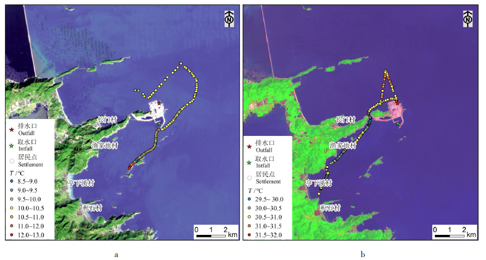
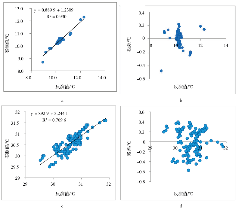
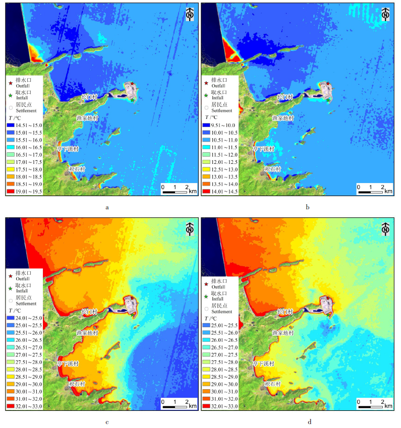
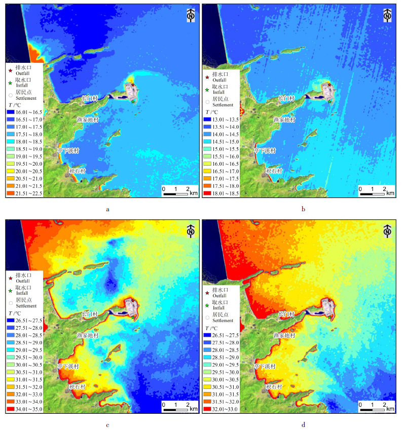
This article made a temperature field analysis in a nearshore waters of a nuclear power plant in Fujian Province,and uses Landsat-8/9 TIRS thermal infrared satellite remote sensing data was used to study the temperature field distribution characteristics in different seasons before and after nuclear power operation. The research results show that the temperature inversion results of Landsat-8/9 TIRS data based on the radiative transfer equation algorithm have high reliability. Before the operation of nuclear power plants,there were significant differences in temperature field characteristics in different seasons in the sea area near the nuclear power plant site. In winter,the temperature field was generally more uniform,slightly higher in the south than in the north and slightly higher in the east than in the west. The water temperature near the water intake was slightly higher than that near the drainage outlet. The maximum temperature difference within 4 km of the plant site was about 1.5 ℃,and within 2 km was about 1.0 ℃. In summer,there was a large temperature difference in the region,showing the characteristics of being higher in the north and lower in the south,and higher in the west and lower in the east. The maximum temperature difference within 4 km of the plant site was about 5.5 ℃,and within 2km was about 2.5 ℃,and some parts were distributed in a disorderly manner. The water temperature near the drainage.After the operation of the nuclear power plant,the characteristics of the regional temperature field are basically the same as before,but there are obvious high-temperature bright spots at the drainage outlet,with a maximum temperature exceeding the surrounding area by 3.0 ℃. The intensity and area of the high-temperature bright spots in winter are greater than those in summer,indicating that the impact of thermal drainage discharge on the temperature field in the nearby sea area is stronger in winter than in summer.The flow direction of the current affects the local distribution of the temperature field,and the diffusion direction of the warm water discharge is related to the flow direction of the current. The Landsat-8/9 TIRS data basically meet the needs of regional temperature field distribution research,but it is difficult to realize the monitoring of full tidal temperature and drainage.
Zhengjian JIANG , Enguo WANG . Analysis on temperature field in the coastal area of a nuclear power plant based on satellite remote sensing[J]. World Nuclear Geoscience, 2025 , 42(1) : 178 -186 . DOI: 10.3969/j.issn.1672-0636.2025.01.015
表1 卫星遥感数据源概况Table 1 Overview of satellite remote sensing data sources |
| 数据类型 | 波段范围/μm | 空间分辨率/m | 获取时间 | 运行工况 | 潮态 |
|---|---|---|---|---|---|
| Landsat-8 TIRS | B10:10.6~11.9 | 100 | 2018-12-17 10:26 | 未运行 | 落潮 |
| Landsat-8 TIRS | B10:10.6~11.9 | 100 | 2022-07-21 10:26 | 未运行 | 落潮 |
| Landsat-9 TIRS | B10:10.6~11.9 | 100 | 2022-07-29 10:26 | 未运行 | 涨潮 |
| Landsat-8 TIRS | B10:10.6~11.9 | 100 | 2023-01-29 10:26 | 未运行 | 涨潮 |
| Landsat-9 TIRS | B10:10.6~11.9 | 100 | 2023-12-07 10:26 | 机组运行 | 落潮 |
| Landsat-8 TIRS | B10:10.6~11.9 | 100 | 2023-12-31 10:26 | 机组运行 | 涨潮 |
| Landsat-8 TIRS | B10:10.6~11.9 | 100 | 2024-07-10 10:26 | 机组运行 | 涨潮 |
| Landsat-9 TIRS | B10:10.6~11.9 | 100 | 2024-08-03 10:26 | 机组运行 | 落潮 |
| 1 |
王薇, 何桂萍, 关骁倢, 等. 我国滨海核电厂取排水方式现状及其对海洋生态环境的影响[J]. 浙江大学学报(理学版), 2024, 51(6):769-780.
|
| 2 |
李毅, 周大颜, 陈晓磁, 等. 模拟夏季温排水温升对福宁湾常见海洋生物的热耐受性研究[J]. 海洋科学, 2020, 44(12):61-68.
|
| 3 |
蔡显岗, 张泽宇, 张路怀, 等. 对核电厂环境影响评价相关问题的探讨[J]. 核安全, 2022, 21(6):42-46.
|
| 4 |
陈望. 温排水效应对秦山核电厂1号机组的影响及应对措施[J]. 中国核电, 2021, 14(1):114-119.
|
| 5 |
王祥, 苏岫, 王林, 等. 滨海核电厂温排水空间分布无人机遥感识别及驱动力分析[J]. 海洋环境科学, 2023, 42(4):542-549.
|
| 6 |
张琳敏, 梅格致, 刘明亮, 等. 千岛湖水体表层温度遥感估算方法对比[J]. 遥感学报, 2024, 28(8):2113-2130.
|
| 7 |
陈小莉, 段亚飞, 赵懿珺, 等. 基于数值模拟和原型观测联合的电厂温排水影响评价[J]. 水利学报, 2023, 54(1):94-104.
|
| 8 |
|
| 9 |
吴传庆, 王桥, 王文杰, 等. 利用TM影像调查和评价大亚湾温排水热污染[J]. 中国环境调查, 2006, 22(3):80-84.
|
| 10 |
于杰, 李永振, 陈丕茂, 等. 利用Landsat TM6数据反演大亚湾海水表层温度[J]. 国土资源遥感, 2009(3):24-29.
|
| 11 |
陆衍, 阚芃芃. 基于 ETM+影像的田湾核电站温排水影响分析[J]. 上海国土资源, 2012, 33(4):44-47.
|
| 12 |
许静, 朱利, 姜建, 等. 基于HJ-1B与TM热红外数据的大亚湾核电基地温排水遥感调查[J]. 中国环境科学, 2014,(34):1181-1186.
|
| 13 |
石海岗, 梁春利, 张建永, 等. 基于 CBERS-04 星田湾核电温排水遥感监测研究[J]. 地理空间信息, 2019, 17(12):75-80.
|
| 14 |
王雅萍, 马秀秀, 李家国, 等. 核电温排水基准温度星地协同提取与分析—以宁德为例[J]. 遥感学报, 2023, 27(8):1899-1913.
|
| 15 |
张晓峰, 徐京平, 张曼祺, 等. Landsat-8 热红外数据监测田湾核电站温排水分布[J]. 海洋科学进展, 2019, 37(3):518-525.
|
| 16 |
张建永, 梁春利, 石海岗, 等. 热红外遥感技术在核电站温排水监测中的应用[J]. 铀矿地质, 2021, 37(3):534-540.
|
| 17 |
朱欧娜, 田义超. 基于Landsat-8 TIRS的防城港核电站温排水分布规律研究[J]. 生态科学, 2023, 42(5):25-30.
|
| 18 |
韩涛, 张阔, 王方, 等. 基于Landsat8的海阳核电厂周边海域水温监测[J]. 地理空间信息, 2022, 20(09):81-85+94.
|
| 19 |
石海岗, 薛庆, 章新益, 等. 基于遥感的海域环境变化监测分析[J]. 环境监测管理与技术, 2024, 36(1):53-56.
|
| 20 |
毕云天, 胡日军, 陈娟娟, 等. 福宁湾及附近海域悬沙粒度与影响因素[J]. 海洋地质与第四纪地质, 2024, 44(01):15-29.
|
| 21 |
卢响军, 许尘璐, 郭金金. 基于Landsat 8数据的地表温度反演方法对比分析[J]. 干旱环境监测, 2023, 37(3):138-144.
|
| 22 |
段四波, 茹晨, 李召良, 等. Landsat卫星热红外数据地表温度遥感反演研究进展[J]. 遥感学报, 2021, 25(8):1591-1617.
|
| 23 |
石海岗, 梁春利, 张建永, 等. 岸线变迁对田湾核电站温排水影响遥感调查[J]. 国土资源遥感, 2020, 32(2):196-203.
|
| 24 |
张春雷, 高丽辉, 石海岗, 等. 田湾核电温排水遥感监测与数模一致性分析[J]. 环境监测管理与技术, 2018, 30(3):67-71.
|
/
| 〈 |
|
〉 |