• SATI Vishwambhar Prasad , a, b, *
展开

收稿日期: 2023-05-03

  修回日期: 2024-01-29

  录用日期: 2024-05-29

  网络出版日期: 2025-08-12

Economic significance and environmental impacts of the Song Dam Drinking Water Project (SDDWP) in Garhwal Himalaya

  • SATI Vishwambhar Prasad , a, b, *
Expand
  • aDepartment of Geography and Resource Management, Mizoram University, Aizawl, 796004, India
  • bImpact Policy Research Institute, New Delhi, 110017, India
*E-mail address: (Vishwambhar Prasad SATI).

Received date: 2023-05-03

  Revised date: 2024-01-29

  Accepted date: 2024-05-29

  Online published: 2025-08-12

本文引用格式

SATI Vishwambhar Prasad . [J]. Regional Sustainability, 2024 , 5(2) : 100145 . DOI: 10.1016/j.regsus.2024.100145

Abstract

With the population growth through natural growth and migration, coupled with the city expansion, it is the fact that Dehradun City in India faces severe water scarcity. Therefore, the Song Dam Drinking Water Project (SDDWP) is proposed to provide ample drinking water to Dehradun City and its suburban areas. This paper examined economic significance and environmental impacts of the SDDWP in Garhwal Himalaya, India. To conduct this study, we collected data from both primary and secondary sources. There are 12 villages and 3 forest divisions in the surrounding areas of the proposed dam project, of which 3 villages will be fully submerged and 50 households will be affected. For this study, 50 heads of the households were interviewed in the 3 submerged villages. The questions mainly focused on economic significance, environmental impacts, and rehabilitation issues of the dam project. The findings of this study indicate that economic significance of the dam project is substantial, including providing ample water for drinking and irrigation, contributing to groundwater recharge, creating job opportunities, and promoting the development of tourism and fisheries in the Doon Valley. In terms of the rehabilitation of the affected people, there are only 50 households in need of rehabilitation. Currently, the arable land of these affected people is not sufficient to sustain their livelihoods. The entire landscape is fragile, rugged, and precipitous; therefore, the affected people are willing to rehabilitate to more suitable areas in the Doon Valley. Moreover, it is essential to provide them with sufficient compensation packages including the compensation of arable land, houses, cash, common property resources, institutions, belongingness, and cultural adaptation. On the other hand, the proposed dam project will have adverse environmental impacts including arable land degradation, forest degradation, loss of fauna and flora, soil erosion, landslides, and soil siltation. These impacts will lead to the ecological imbalances in both upstream and downstream areas. This study suggests that the affected people should be given sufficient compensation packages in all respects. Afforestation programs can be launched in the degraded areas to compensate for the loss of forest in the affected areas.

1. Introduction

The Himalayan region is characterized by fragile ecology, rough and rugged terrain, and high land degradation. It suffers from devastating natural disasters every year, including earthquakes, debris flows, flash floods, landslides, and rock falls (Sharma, 2014; Agoramoorthy, 2015; Sati, 2022). The intensity of vulnerability and risk has increased due to the construction of mega-storage dams. Meanwhile, the Himalayan region is geographically remote and economically underdeveloped. Many people there depend on natural resources for their livelihoods. Additionally, agriculture is the main source of income and the main occupation of local people. Infrastructural facilities are limited, as a result, many people are living below the poverty line (Sati, 2019). The development of infrastructural facilities, including the construction of river valley project, is the hope of the people and an urgent need to reduce poverty and attain food security.
The river valley dam project can promote socio-economic development. According to Fischer et al. (2005), the dam project involves large-scale engineering works or activities that could have significant impacts on the socio-economic conditions of surrounding areas. Positive outcomes include providing ample water for drinking and irrigation, contributing to groundwater recharge, creating job opportunities, and promoting the development of tourism and fisheries. On the other hand, environmental impacts of the dam project are significant, affecting existing habitats, stream hydrology, stream chemistry, sediment transport, and migratory patterns (Yuksel, 2009). The cutting of trees in the catchment area due to dam construction has led to ecological imbalances (Grimay, 2006). Additionally, dams degrade upstream-downstream ecosystems and fragment river ecosystems, contributing to climate change. This further leads to the extinction of aquatic species and the disappearance of many bird species (Barcott, 2008). Meanwhile, Kucukali (2011) observed that river valley project may pose mixed socio-economic and environmental impacts, including water quality deterioration, soil erosion, loss of flora and fauna, and noise pollution. Socio-economic conditions are also influenced by the construction of dam project (Wittwer, 2009). However, economic significance and environmental impacts of dam construction are very selective both spatially and socially.
The Uttarakhand Himalaya has a potential of 27.000×10⁹ W for hydroelectricity generation from 450 hydropower projects. Currently, there are a total of 92 projects with a capacity of 3.620×10⁹ W that have been constructed, and 34 projects are under construction (Pandit and Grumbine, 2012; Grumbine et al., 2013; Sati, 2014; Sati et al., 2019). These projects generate revenue of more than 0.130×10⁹ USD/a. In this region, every river valley has one or more hydropower projects. Dams are constructed in the highly fragile landscapes of the Himalaya, which are the most vulnerable to natural disasters and slope instability (Strahorn, 2011; Mayor et al., 2017). Some mega hydropower projects, such as the Tehri High Dam (India), have partially and fully affected 114 villages. The rehabilitation issue was very complex, and therefore, the dam projects took 34 a to complete, instead of the initially estimated 10 a. The Srinagar Dam, Vishnu Prayag Dam, and Vishnu Gad-Tapovan Dam in India faced various issues related to environmental impacts and the rehabilitation of the affected people. Although hydropower projects can generate electricity and provide ample water for drinking and irrigation, they adversely impacted terrestrial and aquatic ecosystems, leading to the depletion of biological diversity (Pandit and Grumbine, 2012). Furthermore, these projects have a significant impact on the diversity and distribution of fish fauna (Bhatt et al., 2012; Ziv et al., 2012; Erlewein, 2013; Joshi et al., 2014). The Environment Protection Act of India was launched in 1986 with the objective of assessing the adverse and favorable impacts of hydropower projects. However, the implementation of the environmental impact assessment (EIA) was inadequate (Grumbine and Pandit, 2013). Meanwhile, the EIA is a method for achieving sustainability if adequately implemented (Jha-Thakur, 2011; Fischer, 2014; Diduck and Sinclair, 2016; King and Smith, 2016). Several scholars have conducted studies on the regulatory framework and existing procedures of the EIA (Panigrahi and Amirapu, 2012; Ghose, 2013).
Apart from the EIA, the social impact analysis (SIA) of hydropower projects is equally important. Human displacement, the rehabilitation of the affected people, and economic improvement of the poor people due to the commencement of hydropower projects remained the major social issues in the Uttarakhand Himalaya (Bhatt et al., 2016). Pandit (2017) has emphasized the need for assessing the carrying capacity of the region before planning the construction of hydropower projects. The Song Dam Drinking Water Project (SDDWP) in India has passed both the EIA and SIA, and has witnessed that it will have a significant impact on socio-economic development and environment in the Doon Valley.
Dehradun, a metro city in India, is located in the Doon Valley, and surrounded by the mighty Ganga River to the east and the Yamuna River to the west. The Doon Valley is a beautiful valley, encompassed by the Raja Ji National Park and the Shivalik Hills. The population of Dehradun City has increased from 0.427×10⁶ persons in 2001 to 0.570×10⁶ persons, marking a 33.49% decadal increase. The estimated population of the city in 2021 is expected to be more than 0.700×10⁶ persons. With the population growth through natural growth and migration, coupled with the city’s expansion both vertically and horizontally, Dehradun City is grappling with severe water scarcity. Vast arable land has been transformed into a concrete jungle. Most of the city’s water supply comes from groundwater, however, the groundwater level is depleting gradually (Parvaiz et al., 2017). Groundwater serves as the primary source of drinking water in Dehradun City, meeting about 80.00% of the city’s water needs through tube wells, with the remaining 20.00% sourced from other sources. However, with the increasing demand for groundwater and shrinking water sources, water scarcity is becoming more prevalent. The Rispana River in Dehradun City is in a state of decline. In anticipation of future water scarcity, the Department of Irrigation, Government of Uttarakhand, has decided to construct a dam on the Song River in Sondhana village, near Mal Devta, spanning both Tehri and Dehradun districts in India. The primary objective of the dam project, named the SDDWP, is to provide ample drinking water to Dehradun City and its suburban areas. The project is designed to supply water until 2072. The secondary objective includes the revival of the highly polluted Rispana and Bindal streams, which flow from the center of Dehradun City. Additionally, the project also aims to generate electricity (6.000×10⁶ W/a), contribute to groundwater recharge, create creating job opportunities, and promote the development of tourism and fisheries. The proposed height of the dam is 131.6 m.
The proposed SDDWP will have some economic significance, environmental impacts, and rehabilitation issues. Although it aims to provide ample water for drinking and irrigation, it is anticipated to lead to environmental degradation and influence the rehabilitation of the affected people to a certain extent. However, the dam project also has some environmental impacts including arable land degradation, forest degradation, loss of fauna and flora, soil erosion, landslides, and soil siltation. In addition to these mentioned impacts, the rehabilitation issues associated with the dam project are also important. Often, the compensation of arable land, houses, cash, common, property resources, institutions, belongingness, and cultural adaption is not met adequately due to mismanagement (Huber, 2019). It is crucial for properly evaluating the economic significance, environmental impacts, and rehabilitation issues of the dam project. Therefore, a comprehensive analysis of the dam project is deemed as inevitable before their commencement.

2. Materials and methods

2.1. Study area

The Song River (30°17′00′′-30°21′00′′N, 78°05′00′′-78°17′00′′E) flows through the western part of the Central Himalaya, India; it originates from the downslope of the Surkanda Shaktipeeth Mountains (2700.0 m a.s.l.) and courses through Dhanaulty Mountains and the southern slope of the Mussoorie Mountains. Figures 1 and 2 show the overview of the Song River Basin and the affected areas of the dam project, respectively. As one of the largest rivers in the Doon Valley, it boasts several small spring-fed tributaries such as Kali Gad, Shahastradhara, Asan, Rispana, and Bindal rivers, with some drying up during the summer season. After traversing approximately 70.0 km from its source area, the Song River merges with the mighty Ganga River near Raiwala, positioned between Haridwar and Rishikesh (315.0 m a.s.l.). The river’s basin area spans 8500.0 hm2, with Haridwar City covering about 0.36% of this area. The Song River flows through mountainous and plain regions, with around 90.00% of its upstream area falling under slope ranges between 20.00% and 100.00%. Downstream area transforms into a fertile plain. In this basin, the forest covers about 80.00% of the total area, featuring tropical dry deciduous forest, subtropical pine forest, and degraded forest (Champion and Seth, 1964) as the primary types. The Forest Survey of India (2019) recorded a rich biodiversity, including 26 trees, 13 shrubs, 17 herbs, 55 species of avifauna, and 4 species of fish. Additionally, 14 reptiles and mammals were documented. The grazing land and arable land occupy approximately 10.00% and 8.00% of the study area, respectively. About 85.00% of the basin is covered by excessively drained loamy and loamyskeletal soil with moderately shallow to very shallow soil depth. Landslides are common due to high fragility, steep slopes, and mining activities. The Song River is recognized as the lifeline of the Doon Valley, providing ample water for drinking and irrigation. The upstream area of the river is highly vulnerable to natural disasters. A recent example occurred on 19 August 2022, when a cloudburst-triggered flash flood in the upstream area of the Song River resulted in the unfortunate loss of 13 lives, and the missing of more than 20 persons. Additionally, 4 bridges and about 20 houses collapsed, and a vast arable land was washed away (Sati, 2023).
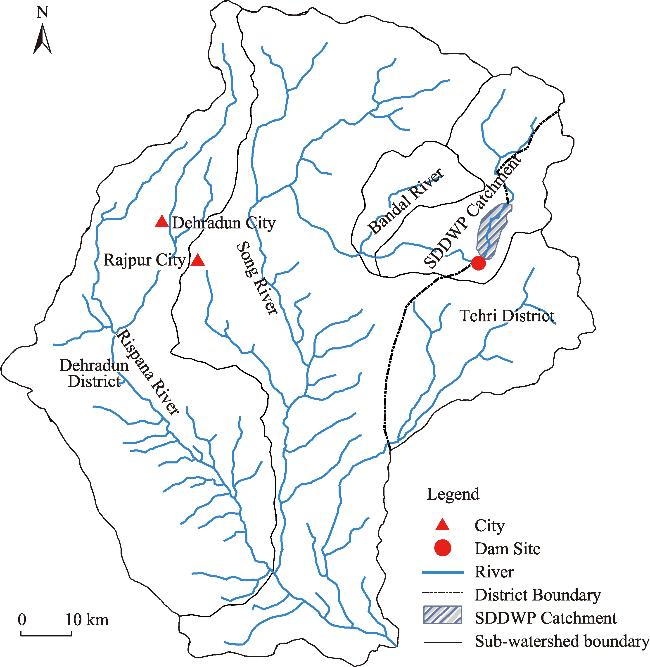
Fig. 1. Overview of the Song River Basin in India. SDDWP, Song Dam Drinking Water Project.
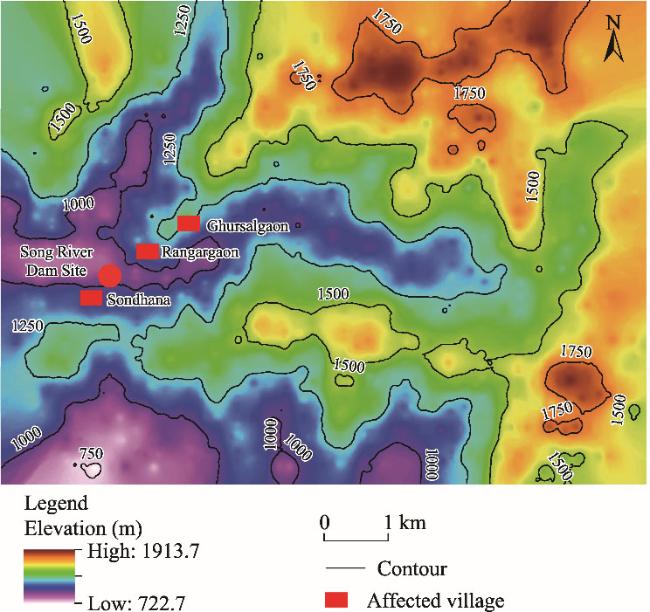
Fig. 2. Elevation distribution of the SDDWP and its affected villages.
The SDDWP is proposed to established in Sondhana village (30°18′60′′N, 78°11′30′′E), with an elevation of 1006.0 m a.s.l. The Song River divides Sondhana village into two parts: the western part of the village falls in Dehradun District, and the eastern part belongs to Tehri District. Sondhana village is located approximately 25.0 km from the Dehradun railway station. The climate of the study area is humid and subtropical, with temperatures reaching up to 38°C in summer and receding to 13°C in winter. The average annual precipitation is 2247 mm, with the maximum precipitation occurring in the monsoon season. Low precipitation occurs in winter due to western disturbances. The proposed dam is planned to be constructed using roller-compacted concrete (RCC). The catchment area will be relatively small, covering 64.8 hm2, and the length of the catchment will be 3.5 km (Table 1). The forest in the area is sparsely distributed, mainly characterized by bushes and scrubs in the valley and pine forests in the midstream and upstream areas. The dam project will fully affect 50 households in Sondhana, Rangargaon, and Ghurshalgaon villages. The construction of the dam project is expected to commence soon, as the Ministry of Environment, Forests, and Climate Change has already granted permission. The estimated cost of the project is 0.019×10⁹ USD, and a loan has been sanctioned by the Agency French Development (AFD) Bank of France.
Table 1 Description of the Song River Basin and Song Dam Drinking Water Project (SDDWP).
Feature Value
Dam site Sondhana village
Elevation (the base level where the dam project is proposed) (m) 880.0
Basin area of the Song River (hm2) 8500.0
Annual precipitation in the Song River Basin (mm) 1250-2800
Maximum height from the deepest foundation (m) 131.6
Maximum height from the riverbed (m) 109.0
Total length of the Song River (km) 70.0
Length of the main river in the basin (km) 28.3
Length of the SDDWP catchment (km) 3.5
Area of SDDWP Catchment (hm2) 64.8
Live storage (hm2) 26.4
Arable land (%) 8.00
Ecosystem services payment for the affected people (×106 USD) 0.057
Objective Providing ample water for drinking and irrigation to Dehradun City and its suburban areas.
Electricity generation (×106 W/a) 6.000
The social structure of the study area is marked by caste systems, encompassing the Brahmins, Rajputs, Other Backward Classes (OBC), Scheduled Castes (SC), and a presence of a few Scheduled Tribes (ST). Notably, there has been an increase in the population of the OBC due to migration. The total population within the Song Dam Basin is below 0.050×10⁶ persons. Over 70.00% of the population engages in traditional agriculture, resulting in notably low agricultural output and overall economic underdevelopment in the region. The challenging terrain and delicate landscape contribute to limited infrastructure in these villages, some of which are accessible only by trekking. Educational institutions are scarce, leading to low education levels among the residents. Despite proximity to Dehradun and Mussoorie cities, the socio-economic development in the SDDWP catchment area remains low.

2.2. Data sources and methods

This study selected primary and secondary data, and employed a mixed approach, incorporating both qualitative and quantitative methods. Primary information pertaining to the proposed micro dam project, including catchment area, catchment dimensions, water supply capacity, and electricity generation, was obtained from the Department of Irrigation, Government of Uttarakhand, India (https://uttarakhandirrigation.com). The project will impact 12 villages and 3 forest divisions. Sondhana, Rangargaon, and Ghurshalgaon villages will be entirely submerged, including 50 households. A 4-d field survey in July 2022 was focused on these submerged villages, capturing socio-economic data of the affected households. A structured questionnaire was conducted with the head of these 50 affected household, including the aspects of population, agriculture, livestock, and perceptions regarding the dam project. Statistical parameters, including mean, standard deviation, frequency, and percentage, were obtained using the Microsoft Office Excel (Microsoft, Redmond, the United States). Additionally, an elevation model was utilized to understand the slope characteristics of the study area.

3. Results

3.1. Affected villages by the Song Dam Drinking Water Project (SDDWP)

As stated, 3 villages (Rangargaon, Ghurshalgaon, and Sondhana) will be fully submerge by the construction of the dam project, with a total of 50 households, comprising 486 persons. The female population is significantly lower than the male population (Table 2). Sondhana village is situated on both sides of the Song River, with a half of it falling in the Tehri District and the other part in the Dehradun District. Therefore, the number of households affected in this village is the highest.
Table 2 Villages and households affected by the construction of the SDDWP.
District Village Households Males Females Total population
Tehri Rangargaon 1 2 2 4
Ghurshalgaon 24 100 55 155
Sondhana 17 205 69 274
Dehradun Sondhana 8 41 12 53
Total 50 348 138 486
The male-female ratio, literacy rate, and occupation of the heads of households were collected and analyzed (Table 3). Approximately 82.00% of the interviewed heads of households are males, while only 18.00% are females. Around 70.00% of the heads of households are literate, with a notable concentration of illiteracy among the female heads of households. In the submerged villages, there are a few primary and secondary schools, as well as an inter-college. Degree College is situated approximately 10.0 km from the submerged villages, at the Mal Devta service center. Medical facilities are minimal. Agriculture is the primary occupation of the respondents, with approximately 68.00% of the heads of households engaged in agriculture. About 32.00% of the heads of households are engaged in public and private jobs, predominantly as drivers of tempo-taxis and service staffs in hotels. A few of them are working as school teachers. Additionally, in terms of caste systems, the OBC population comprised 51.30%, the general category is 42.30%, and 6.40% of the population belongs to the SC. Due to the proximity of the study area to Dehradun City, most of the OBC population has migrated to the city.
Table 3 Characteristics of the heads of the affected 50 households.
Variable Frequency Percentage (%)
Gender Males 41 82.00
Females 9 18.00
Literacy Yes 35 70.00
No 15 30.00
Occupation Agriculture 34 68.00
Public and private jobs 16 32.00
The mean value of arable land is 0.7 hm2/household, with the minimum of 0.3 hm2/household and the maximum of 1.0 hm2/household, indicating land scarcity. The mean value of the number of livestock is 5 per household, emphasizing economic significance of livestock rearing. Cows and buffalos contribute to the livelihood of marginal farmers by providing milk and manure, while oxen are utilized for plowing fields. The produced milk is sold in the local market. Despite these economic activities, the monthly income is notably low due to the predominant engagement in agriculture with a limited output. The mean value of monthly income is 200.000 USD/household, with the minimum of 100.000 USD/household and the maximum of 300.000 USD/household. Given the large family size, the monthly income proves insufficient to adequately support a sizable household.
The primary crops in the affected areas include paddy, maize, cucumber, pumpkin, peas, beans, green chili, turmeric, banana, and mango. Notably, around 95.00% of arable land is irrigated. The residents of the impacted regions rely extensively on forest products for various needs. This dependence encompass fodder for feeding animals, firewood for cooking, and maintaining warmth in houses during the winter. Additionally, they harvest some wild fruits and vegetables, sustaining their livelihoods with minimal environmental impacts. The presence of ample grazing land not only facilitates grazing, but also serves as a source of income for the local people.

3.2. Distribution of land use and land cover types in the Song River Basin

The basin area of the Song River is relatively small, covering a geographical area of 8500.0 hm2. Within this region, 80.00% (6800.0 hm2) is forest, while 7.00% is arable land, which is a limitation for the predominantly agriculture-dependent livelihoods (Fig. 3). Forest affected by the dam is sparse and characterized by bushes and scrubs. The insufficiency of arable land poses challenges for the local residents, particularly given their heavy reliance on agriculture. Despite this, grazing land covers 8.00% of the study area, which is sufficient to meet the grazing needs of many marginal farmers. Settlements are dispersed, with a noticeable distance between them, mainly along the river. The upstream area, earmarked for the dam project, is mountainous, rough, and rugged, contributing to a sparse population distribution. The geomorphic features vary significantly, with some plots barren and others swampy.
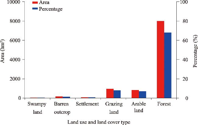
Fig. 3. Area and percentage of land use and land cover types in the Song River Basin.

3.3. Economic significance of the SDDWP

The SDDWP is designed to address various needs, including providing ample water for drinking and irrigation, contributing to groundwater recharge, creating job opportunities, promoting the development of tourism and fisheries, and ultimately enhancing local development. The project will provide ample water for drinking and irrigation to Dehradun City and its suburban areas for an estimated 50-a period. The Department of Irrigation, Government of Uttarakhand has projected that the population of Dehradun City will reach 1.912×10⁶ persons by 2072, with a corresponding water demand of 258.21×10⁶ L/d. The SDDWP intends to supply approximately 150.21×10⁶ L/d of water, and an additional 86.32×10⁶ L/d will be sourced from groundwater. While there will be 21.68×10⁶ L/d (8.40%) water shortfall, this gap will be addressed by utilizing other water sources. The catchment is expected to not only fulfill water needs but also attract tourists from the surrounding areas, thereby enhancing the income and economy of the local people.

3.4. Environmental impacts of the SDDWP

Major environmental impacts of the dam project include arable land degradation, forest degradation, loss of fauna and flora, soil erosion, landslides, and soil siltation. Additionally the impact on grazing land and arable land are significantly concerned (Basson, 2004). The catchment area of the SDDWP is situated in both Tehri and Dehradun districts, characterized by sparse vegetation consisting mainly of bushes and scrubs. Notably, there are no parks, sanctuaries, conservation reserves, biosphere reserves, or eco-sensitive areas in the affected zones of the dam project. The Rajaji National Park is located 18.0 km from the dam project site, with the dam itself situated 8.1 km away from the park’s buffer zone. In contrast to other dam projects in the Garhwal Himalaya, adverse environmental impacts of the SDDWP are considered nominal.
Simultaneously, the dam construction will result in the submergence of 128.0 hm2 of forest, including sparse subtropical deciduous and pine trees, along with 11.0 hm2 of non-forest, encompassing arable land. Further, approximately 13.00% of grazing land was submerged. Additionally, the project will lead to the submergence of 50 households and cowsheds, impacting a few government and private institutions, playgrounds, and roads. The terrain in the affected area is fragile, and the landscape is prone to natural hazards, particularly landslides. This vulnerability increases the risk of excessive soil erosion, contributing to soil siltation problems. However, due to the construction of a relatively small dam project and the limited area of submergence, the overall environmental impacts are expected to be minimal.
In addition to the 3 villages that will be fully submerged, 9 villages and 3 forest divisions will be partially affected by the construction of the dam project. Land acquisition has already commenced (Table 4). In addition, we found that the overall adverse impacts of the dam project would be minimal due to the small amount of forest and non-forest resources affected by the dam construction.
Table 4 Land acquisition for the construction of the SDDWP.
Village or forest division Forest area (hm2) Non-forest area (hm2)
Village Rangargaon# 15.0 0.4
Ghurshalgaon# 18.0 4.3
Plad 10.0 2.1
Sondhana# 4.3 3.8
Bharwakatal 0.5 -
Shripur 0.4 -
Thaiwa 0.1 -
Rainiwala 0.4 -
Khairimansingh 1.5 -
Pustadi 0.8 -
Kulhanmansingh 0.6 -
Marotha 0.2 -
Forest division Raipur Range under Mussoorie Forest Division 44.0 -
Mussoorie Range under Mussoorie Forest Division 2.0 -
Thano Range under Dehradun Forest Division 30.0 -
Total 128.0 10.6

Note: #, fully submerged villages; -, no non-forest distribution.

3.5. Rehabilitation issues

Only Rangargaon, Ghurshalgaon, and Sondhana villages have been fully submerged by the SDDWP, all of which are being adversely affected by the construction of the dam project. A total of 50 households, with a population of 486 persons, will bear the impact. These affected villages are situated in remote areas. The terrain is fragile, and the landscape is susceptible to natural disasters. Arable land is scarce, and essential infrastructural facilities, including transportation and educational institutions, are inadequate. Therefore, the affected people expressed a willingness to relocate to more suitable areas within the Doon Valley.
The overall economic significance, environmental impacts, and rehabilitation issues induced by the construction of the SDDWP are outlined in Table 5. The description presented in Table 5 is derived from personal observation, people’s perceptions, and secondary sources. Economic significance of the dam project is expected to be largely favorable. However, environmental impacts are anticipated to be partially adverse. Rehabilitation in Sondhana, Rangargaon, and Ghurshalgaon villages is expected to have both favorable and adverse impacts. The rehabilitation of the affected people is not anticipated to be problematic if rehabilitation conducted in safe areas. However, the issues of common property resources and belongingness are expected to have adverse impacts. In summary, the proposed dam project is projected to have a favorable impact on the local economy and people overall.
Table 5 Economic significance, environmental impacts, and rehabilitation issues of the SDDWP.
Aspect Impact
Economic significance Providing ample water for drinking
and irrigation
Favorable
Contributing to groundwater recharge Favorable
Creating job opportunities Partially favorable
Promoting the development of
tourism and fisheries
Partially favorable
Environmental impact Arable land degradation Partially adverse
Forest degradation Adverse
Loss of fauna and flora Adverse
Soil erosion Adverse
Landslides Adverse
Soil siltation Adverse
Rehabilitation issue Arable land compensation Favorable
House compensation Favorable
Cash compensation Partially adverse
Common property resource
compensation
Adverse
Institution compensation Favorable
Belongingness compensation Partially adverse
Cultural adaptation compensation Adverse

3.6. People’s perceptions of the SDDWP

During the field visit, the heads of households were interviewed to gather their perceptions on economic significance, environmental impacts, and rehabilitation issues of the dam project. A set of 4 questions was posed. The overall response from the heads of households was positive towards the construction of the dam project. Many heads of households expressed their favors for the project, believing it to be economically viable, with low adverse environmental impacts, and foreseeing it as a catalyst for local development (Table 6). Rehabilitation issues, according to the respondents, are not expected to be significant. This is attributed to the mountainous, stony, and largely unproductive nature of the affected areas. Additionally, settlements are sparsely distributed, and only 50 households will be affected by the dam project. These affected households engaged in limited economic activities to sustain their livelihoods, primarily relying on traditional agriculture and grazing land. However, the output from these activities is deemed insufficient for sustainable livelihoods for local people. Consequently, most households expressed a willingness to undergo rehabilitation if the dam project authorities relocate them to the fertile area in the Doon Valley, providing houses and sufficient rehabilitation packages.
Table 6 Perceptions of the heads of households on the construction of the SDDWP.
Question Perception Frequency Percentage (%)
Is this dam project economically viable? Yes 18 36.00
No 17 34.00
Do not know 15 30.00
Does this dam project have adverse environmental impacts? Yes 26 52.00
No 11 22.00
Do not know 13 26.00
Will this project help in the local development? Yes 29 58.00
No 11 22.00
Do not know 10 20.00
Are you willing to rehabilitate? Yes 34 68.00
No 16 32.00

4. Discussion

The river valley dam projects hold numerous and substantial economic significances in India. Primarily, they play a crucial role in generating electricity, serving as a key driver for economic development. In the Garhwal Himalaya, these dam projects contribute to the production of over 5.523×10⁹ W of electricity, effectively meeting the energy demands of the northern states of India. Additionally, these projects have provided employment opportunities for local unemployed youth, transforming several project areas into popular tourist destinations. Furthermore, the dam projects contribute to the improvement of irrigation facilities, consequently boosting crop production in the watershed areas. These multifaceted impacts underscore the significant role of the river valley dam projects in fostering economic growth and development.
India ranks the 3rd largest dam builder country in the world. Similarly, it has displaced people due to the construction of the dam projects (WGHR, 2012). Meanwhile, the rehabilitation plan in India is not clear and adequate, resulting in enormous challenges for the displaced individuals (Asif, 2000; Negi and Ganguly, 2011). Study has shown that the displaced individuals face significant problems, including starvation and multiple relocations (Ray, 2000). The places where they have been resettled are often converted again for new development projects, leading to additional rehabilitation issues. It is frequently observed that the dam projects are planned without involving the local community, exacerbating the panic surrounding rehabilitation, particularly in Garhwal Himalaya (Sati, 2014).
Compensation packages provided to the displaced individuals are often inadequate, especially for those without legal land rights (Bikash and Manas, 2009). Furthermore, the adjustment to different natural environments and cultures leaves the displaced individuals discontented, and they often return to their native places even after rehabilitation (Baboo, 1997). Consequently, the rehabilitation issues of the dam projects remain pivotal. Despite offering all facilities to the displaced individuals in rehabilitation areas, psychological problems, cultural adaptation, and a sense of belongingness persist. At the national and international levels, several policies have been drafted and implemented for the rehabilitation of the affected people, however, some issues still exist. Apart from compensation for arable land and houses, other factors such as common property land, cremation centers, grazing land, schools, hospitals, and banks are central issues for many dam projects.
This study provides a comprehensive overview of economic significance, environmental impacts, and rehabilitation issues of the SDDWP. Economic significance of the dam project is deemed important, particularly in addressing the future water needs in Dehradun City and its suburban areas. The city’s population is expected to double or more due to natural growth and migration, and current water sources, including groundwater, are depleting, leading to acute water scarcity (Tyagi, 2022). The Doon Valley, renowned for its fertile arable land, offers a solution. While the core of the city has transformed into a concrete jungle, the surrounding areas, including suburbs, still possess suitable ample arable land. The dam project aims to provide ample water for drinking and irrigation, addressing this critical water scarcity. Another crucial economic significance is the potential for tourism development. The dam catchment is expected to attract tourists, contributing to the local development. Furthermore, the dam project is anticipated to create job opportunities for the youth, both during and after its construction, fostering employment growth. Additionally, the project is likely to promote fishery development, further enhancing economic prospects. Together, these factors are expected to bolster the income and economy of the local population, supporting their livelihoods.
In terms of the rehabilitation of the affected people, it is expected to be a manageable issue due to the limited numbers of the affected villages. Only 3 villages will be fully submerged by the dam construction, comprising a total of 50 households and a population of 486 persons. These settlements are sparsely scattered along the Song River,
which is characterized by rough, rugged, and precipitous terrain. Accessibility to these settlements during the monsoon season is challenging, as there is no proper road constructed. Arable land is minimal, and livelihood sources, aside from livestock farming, are negligible. During interviews with the respondents, we observed a willingness to undergo rehabilitation from the affected areas under certain conditions. This study highlights a distinctive feature of the SDDWP compared to other dam projects in the Garhwal Himalaya. Unlike those projects with large environmental impacts, the SDDWP is noted for having small environmental impacts. Moreover, forests are sparsely distributed in the Doon valley, and the entire basin is characterized by stony and precipitous terrain, with limited arable land.
The Garhwal Himalaya has been a witness to numerous prolonged agitations against the construction of river valley dam projects, primarily centered about environmental impacts and the rehabilitation of the affected people. Table 7 outlines some of the prominent river valley dam projects in the region (Sati, 2014). These projects encountered substantial opposition, primarily due to environmental impacts and challenges associated with the rehabilitation of the affected people. Consequently, nearly all these projects experienced significant delays in construction, stretching over several years.
Table 7 Major river valley dam projects in the Garhwal Himalaya.
Dam project River valley Electricity generation (×106 W) Number of submerged villages Performance
Tehri high dam Bhagirathi-Bhilangana 2400.000 114 Delayed
Singoli-Bhatwari Mandakini 90.000 16 Delayed
Pala-Maneri Bhagirathi 480.000 2 Delayed
Tapovan-Vishnuprayag Dhauli Ganga 520.000 5 Delayed
Lata-Tapovan Dhauli Ganga 162.000 5 Delayed
Vishnuprayag Alaknanda 400.000 5 Delayed
Srinagar Alaknanda 330.000 20 Delayed
Netwad-Mori Yamuna 33.000 5 Delayed
Lakhwar-Vyasi Yamuna 120.000 6 Delayed
In this study area, there is an abundance of water with perennial rivers and streams, some of which are formed by glacial meltwater. Although groundwater is also available plenty, it cannot be utilized due to the lack of infrastructural facilities. Further, the small streams flowing from Dehradun City are highly polluted; therefore, the water of these streams is not suitable for domestic purposes (Tyagi, 2022). The increasing population is exacerbating water scarcity, a challenge further intensified by water pollution resulting from industrialization, the growing number of vehicles, and the use of chemical fertilizers in arable land (Sharma et al., 2016). In this context, the SDDWP emerges as a critical solution with the potential to provide ample water to meet the escalating needs of Dehradun City and its suburban areas. The dam project not only demonstrates high economic significance but also minimizes its environmental impacts, particularly in the area of the Song River. The rehabilitation of the affected people can be effectively managed by the relevant authorities. However, a noteworthy challenge in the rehabilitation process pertains to landless farmers. Those who possess arable land under lease agreements that did not officially register in government records may encounter difficulties, as they are typically denied land compensation. Addressing these issues is crucial for ensuring a fair and comprehensive rehabilitation for all affected parties.
The displaced persons of the SDDWP necessitate robust support through appropriate rehabilitation packages, including the compensation of houses, cash, common property resources, institutions, belongingness, and cultural adaptation. Cash compensation holds equal importance, particularly when the affected people are relocated to new areas (Mishra, 2019). In the initial phase, cash compensation becomes vital for addressing needs related to household items, sustaining agricultural practices, maintaining livestock, ensuring children’s education, accessing medical facilities, exploring alternative livelihood options, and meeting various other expenses. Moreover, there are some additional crucial considerations such as addressing cultural adaptation challenges and identifying common property resources in the new areas. In summary, it is essential to adequately and timely provide compensation packages—both in terms of cash and property—to the affected people. This approach can effectively resolve the challenges associated with the construction of the SDDWP, leading to the sustainable development of the Doon Valley.

5. Conclusions

The study underscores that the successful initiation of the SDDWP will have economic significance including providing ample water for drinking and irrigation, contributing to groundwater recharge, creating job opportunities, and promoting the development of tourism and fisheries in the Doon Valley. However, the proposed dam project will have adverse environmental impacts in terms of arable land degradation, forest degradation, loss of fauna and flora, soil erosion, landslides, and soil siltation. To address these challenges, it is imperative to implement suitable policy measures, especially focusing on environmental conservation and rehabilitation of the affected people. The dam project authority should proactively plan for the rehabilitation of the affected people. Compensation packages in the areas where the affected people are resettled should be not only adequate but also delivered in a timely manner. The compensation of arable land, houses, cash, common property resources, institutions, belongingness, and cultural adaptation, should be prioritized for the affected people. To offset the impact on forests, a substantial afforestation program can be initiated in the degraded areas, serving as compensation for the submerged forests. Additionally, efforts should be made to relocate the fauna and flora of the submerged area to safe surrounding zones. Comprehensive and well-thought-out measures will be essential to balance the goals of the dam project with environmental preservation and the well-being of the affected communities.

Authorship contribution statement

Vishwambhar Prasad SATI: conceptualization, methodology, formal analysis, writing - original draft, and writing - review & editing. The author approved the manuscript.

Declaration of competing interest

The author declares that he has no known competing financial interests or personal relationships that could have appeared to influence the work reported in this paper.

Ethics statement

Ethics approval was obtained from the Ethics Committee of Mizoram University, India. In addition, the participants provided their informed consent to participate in this study.

The author sincerely acknowledges the contribution of Miss Vishwani from the Northwestern University, the United States, for improving the English expression of this manuscript.

[1]
Agoramoorthy G., 2015. The future of India’s obsolete dams: Time to review their safety and structural integrity. Futures. 67, 22-25.

[2]
Asif M., 2000. Why displaced persons reject project resettlement colonies? Econ. Polit. Week. 35(24), 2005-2008.

[3]
Baboo B., 1997. Big dams and the tribals:The case of the Hirakud Dam Oustees in Orissa. In: BabooB., (ed.). Contemporary Society: Tribal Studies. New Delhi: Concept Publishing Company, 92-106.

[4]
Barcott B., 2008. The Last Flight of the Scarlet Macaw:One Woman’s Fight to Save the World’s Most Beautiful Bird. New York: Random House, 232-233.

[5]
Basson G., 2004. Hydropower dams and fluvial morphological impacts-an African perspective. Environmental Science, Geography. 1-18.

[6]
Bhat P.A., ul Shafiq M., Mir A.A., et al., 2017. Urban sprawl and its impact on land use/land cover dynamics of Dehradun City, India. International Journal of Sustainable Built Environment. 6(2), 513-521.

[7]
Bhatt J.P., Manish K., Pandit M.K., 2012. Elevational gradients in fish diversity in the Himalaya: Water discharge is the key driver of distribution patterns. PLoS ONE. 7, e46237, doi: 10.1371/journal.pone.0046237.

[8]
Bhatt J.P., Manish K., Mehta R., et al., 2016. Assessing potential conservation and restoration areas of freshwater fish fauna in the Indian river basins. Environ. Manage. 57, 1098-1111.

[9]
Bikash P., Manas B., 2009. Dams, Rivers & People Hirakud Dam: Fifty Mournful Years. [2024-01-23]. http://environmental.in/file/HirakudDam.pdf.

[10]
Diduck A.P., Sinclair A.J., 2016. Small hydro development in the Indian Himalaya: Implications for environmental assessment reform. Journal of Environmental Assessment Policy and Management. 18(2), 1650015, doi: 10.1142/S1464333216500150.

[11]
Erlewein A., 2013. Disappearing rivers: The limits of environmental assessment for hydropower in India. Environ. Impact Assess. Rev. 43, 135-143.

[12]
Fischer G., Shah M., Tubiello F.N., et al., 2005. Socio-economic and climate change impacts on agriculture: An integrated assessment, 1990-2080. Philos. Trans. R. Soc. Lond. Ser. B-Biol. Sci. 360(1463), 2067-2083.

[13]
Fischer T.B., 2014. Environmental impact assessment handbook for Pakistan. Islamabad: International Union for Conservation of Nature (IUCN) Pakistan, 164.

[14]
Girmay Y., 2006. Assessing the Environmental Impacts of a Hydropower Project: The case of Akosombo/Kpong Dams in Ghana. MSc Thesis. Sweden: University of Stockholm.

[15]
Ghose S., 2013. Demystifying the environmental clearance process in India. The West Bengal National University of Journal Sciences. 63, 434-480.

[16]
Grumbine R.E., Pandit M.K., 2013. Threats from India’s Himalaya Dams. Science. 339(6115), 36-37.

[17]
Huber A., 2019. Hydropower in the Himalayan hazardscape: Strategic ignorance and the production of unequal risk. Water. 11(3), 414, doi: 10.3390/ w11030414.

[18]
Jha-Thakur U., 2011. Environmental impact assessment follow-up in India: Exploring regional variation. Journal of Environmental Assessment Policy and Management. 13(3), 435-458.

[19]
Joshi K.D., Jha D.N., Alam A., et al., 2014. Environmental flow requirements of river Sone: Impacts of low discharge on fisheries. Curr. Sci. 107, 478-488.

[20]
King H., Smith L.E.D., 2016. Many rivers to cross: evaluating the benefits and limitations of strategic environmental assessment for the Koshi river basin. Journal of Environmental Assessment Policy and Management. 18(2), 1650011, doi: 10.1142/S1464333216500113.

[21]
Kucukali S., 2011. Risk assessment of river-type hydropower plants using fuzzy logic approach. Energy Policy. 39(10), 6683-6688.

[22]
Mayor B., Rodriguez-Munoz I., Villarroya F., et al., 2017. The role of large and small scale hydropower for energy and water security in the Spanish Duero Basin. Sustainability. 9(10), 1-21.

[23]
Mishra S., 2019. Issues of large-scale dam resettlement and rehabilitation: Case of Bilaspur, Himachal Pradesh. Indian Journal of Public Administration. 65(4), 848-868.

[24]
Negi N.S., Ganguly S., 2011. Development projects vs. internally displaced populations in India: A literature based appraisal. In: Centre on Migration, Citizenship and Development. COMCAD Arbeitspapiere. Working Papers Note 103. Bielefeld, Germany, 1-19.

[25]
Pandit M.K., Grumbine R.E., 2012. Potential effects of ongoing and proposed hydropower development on terrestrial biological diversity in the Indian Himalaya. Conserv. Biol. 26(6), 1061-1071.

[26]
Pandit M.K., 2017. Life in the Himalaya:An Ecosystem at Risk. Cambridge: Harvard University Press, 364.

[27]
Panigrahi J.K., Amirapu S., 2012. An assessment of EIA system in India. Environ. Impact Assess. Rev. 35, 23-36.

[28]
Parshuram R., 2000. Development induced displacement in India. Sarwatch. 2(1), 33-40.

[29]
Sati S.P., Sharma S., Rana N., et al., 2009. Environmental implications of Pancheshwar dam in Uttarakhand (Central Himalaya), India. Curr. Sci. 116(9), doi: 10.18520/cs/v116/i9/1483-1489.

[30]
Sati V.P., 2014. Landscape vulnerability and rehabilitation issues: A study of hydropower projects in the Garhwal region, Himalaya. Nat. Hazards. 75(3), 2265-2278.

[31]
Sati V.P., 2019. Himalaya on the Threshold of Change. Switzerland: Springer International Publishers, 67.

[32]
Sati V.P., 2022. Environmental and economic impact of cloudburst-triggered debris flows and flash floods in Uttarakhand Himalaya: A case study. Geoenviron. Disasters. 9(5), 1-11.

[33]
Sati V.P., 2023. Geo-hydrological disasters in the Uttarakhand Himalaya: assessment and mapping. Nat. Hazards. 120(6), 1-19.

[34]
Sharma M., Pal B., Pal A., et al., 2016. Water Pollution and its effects on human health: A case study of Dehradun City. International Journal for Environmental Rehabilitation and Conservation. 7(2), 17-24.

[35]
Sharma V., 2014. 500 Dams in India over 50 Years Old. [2024-01-23]. http://www.tribuneindia.com/2011/20111205/main7.htm.

[36]
Strahorn E., 2011. The Tentative First Steps in the Creation of a Himalayan Hydroelectricity Market between Bangladesh, Bhutan, India, and Nepal. [2023-04-23]. https://lkyspp.nus.edu.sg/docs/default-source/cag/natbma_wp1121.pdf.

[37]
Tyagi T., 2022. As Temperature Rises, Water Scarcity Worsens in Uttarakhand. [2024-01-23]. https://timesofindia.indiatimes.com/city/dehradun/as-temperature-rises-water-scarcity-worsens-in-ukhand/articleshow/91358815.cms.

[38]
Valdiya K.S., 2014. Damming rivers in the tectonically resurgent Uttarakhand Himalaya. Curr. Sci. 106(12), 1658-1688.

[39]
WGHR (Working Group on Human Rights), 2012. Human Rights in India: Status Report. Working Group on Human Rights in India and the UN, New Delhi. [2024-01-23]. http://www.indianet.nl/pdf/HumanRightsInIndia_StatusReport2012.pdf.

[40]
Wittwer G., 2009. The economic impacts of a new dam in South-East Queensland. Aust. Econ. Rev. 42(1), 12-23.

[41]
Yuksel I., 2009. Dams and hydropower for sustainable development. Energy Sources Part B. 4(1), 100-110.

[42]
Ziv G., Baran E., Nam S., et al., 2012. Trading-off fish biodiversity, food security, and hydropower in the Mekong River Basin. Proc. Natl. Acad. Sci. U. S. A. 109, 5609-5614.

文章导航

/