Research article

Prior-year climate and fuel availability shape fire occurrence in the semi-arid woody lands of Argentina

  • Laura B RODRÍGUEZ 1, 2 ,
  • Silvia S TORRES-ROBLES , 1, * ,
  • Néstor I GASPARRI 2, 3
Expand
  • 1 National University of Río Negro, Atlantic Headquarters, Center for Environmental Studies from Norpatagonia (CEANPa), Viedma 8500, Argentina
  • 2 National Council of Scientific and Technical Research (CONICET), Godoy Cruz 2290, Argentina
  • 3 Institute of Regional Ecology (IER)-CONICET, Faculty of Natural Sciences and Miguel Lillo Institute, National University of Tucumán (UNT), Yerba Buena 4107, Argentina
*Silvia S TORRES-ROBLES (E-mail: )

Received date: 2025-06-21

  Revised date: 2025-12-11

  Accepted date: 2025-12-18

  Online published: 2026-03-12

Abstract

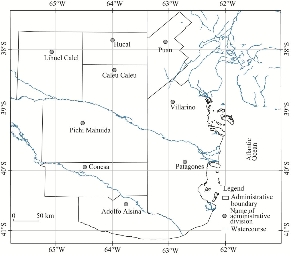
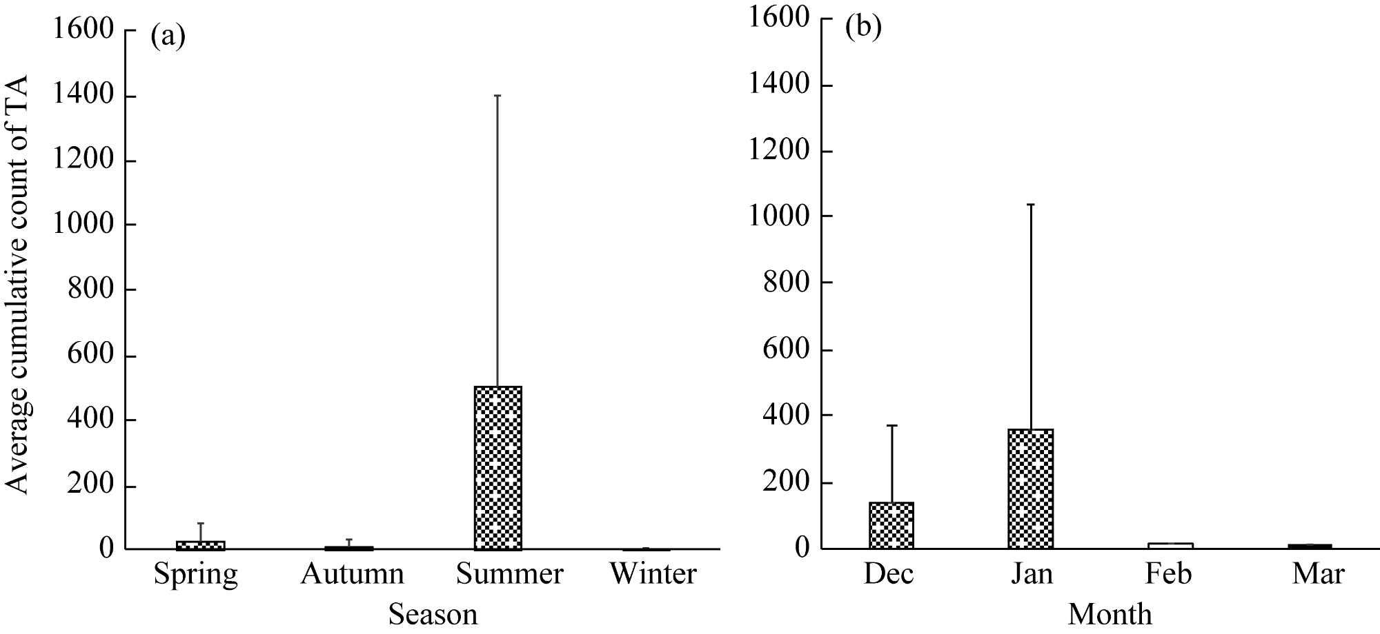
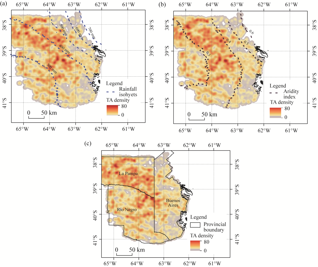
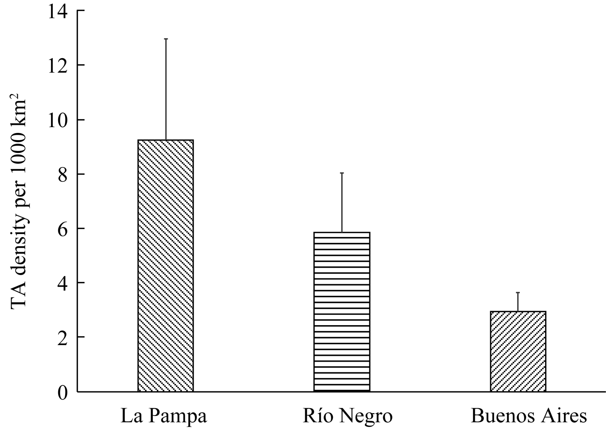
Fire is a fundamental ecological driver shaping natural vegetation patterns. In the semi-arid southern Espinal-Monte ecotone of Argentina, the spatiotemporal patterns of fire occurrence related to and modulated by climatic gradients and antecedent conditions are not well researched. This study examined fire occurrence in the semi-arid southern Espinal-Monte ecotone (southeastern La Pampa, northeastern Río Negro, and southwestern Buenos Aires with an area of 68×103 km2) of Argentina, a key environmental transition zone with pronounced climatic and vegetation gradients. The objective was to identify the spatiotemporal patterns of fire occurrence and their relationship with climatic variables. Thermal anomaly (TA) data from the MODIS (Moderate Resolution Imaging Spectrometer; MOD14) sensor (November 2000-March 2020) with confidence levels >65.0% were analyzed. Climatic variables (rainfall isohyets and aridity indices) were obtained from the WorldClim datasets, and annual meteorological conditions (rainfall and potential evapotranspiration) were calculated using the climatic research unit (CRU) database. Monthly data and moving averages of rainfall and aridity indices from distinct periods (two and three years preceding fire events) were integrated. Spatial analysis was conducted using kernel density estimation on a 10 km×10 km grid to correlate TA with climatic gradients, while linear regression examined relationships between summer TA and meteorological variables over different periods. Results showed that the highest fire occurrence was recorded in summer, with peaks in December and January. Spatially, 55.0% of TA occurred in areas with annual rainfall of 300-400 mm, and 64.5% in areas with an aridity index of 0.3-0.4, forming an arc-like distribution in the center of the ecotone. The highest TA densities were observed in southeastern La Pampa and northeastern Río Negro, decreasing toward southwestern Buenos Aires. Significant correlations (R2>0.700) were found among TA accumulation, aridity index values, and cumulative rainfall from previous two and three years, at both vegetation unit and provincial levels. Summer was the critical season for fire occurrence, with spatial distribution primarily determined by the interaction between climatic conditions and woody biomass availability. The lower fire incidence in southwestern Buenos Aires was linked to sparse woody vegetation and agricultural expansion, which reduced fuel load. These findings reinforce that fuel availability, modulated by climatic conditions from previous years, is a key limiting factor for fire dynamics in this area, and that human activities such as agriculture and grazing alter fire regimes by affecting fuel structure and continuity.

Cite this article

Laura B RODRÍGUEZ , Silvia S TORRES-ROBLES , Néstor I GASPARRI . Prior-year climate and fuel availability shape fire occurrence in the semi-arid woody lands of Argentina[J]. Journal of Arid Land, 2026 , 18(2) : 202 -215 . DOI: 10.1016/j.jaridl.2026.02.002

1 Introduction

Fire constitutes a fundamental ecological driver shaping natural vegetation patterns (Chuvieco, 2009; Di Bella et al., 2011; Di Bella and Posse, 2014). Assessing ecosystem responses to fire disturbances requires a detailed characterization of spatial distribution, frequency, and seasonal dynamics of fire events (Whelan, 1995; Grau and Veblen, 2000). In this context, climate is widely recognized as the principal determinant of fire occurrence, as it influences both the production of fine fuels and their rate of desiccation (Grau, 2001; Di Bella et al., 2011). Consequently, fire ignition and propagation are primarily governed by meteorological conditions as well as the type and moisture content of available fuels (Whelan, 1995; Rollins et al., 2002; Sharples, 2009).
Historically, the interplay between periods favorable to vegetation growth (accumulation of combustible biomass) and intervals marked by intense drought and high temperatures has driven the occurrence of natural fires (Pausas and Keeley, 2021). In arid and semi-arid environments, wildfires typically occur in the years following above-average rainfall, as these conditions enhance primary productivity and the subsequent accumulation of fine fuels (Grau and Veblen, 2000; Aráoz and Grau, 2010; Bravo et al., 2010). Furthermore, in these ecosystems, the availability of fine and dry fuels is often the primary limiting factor for fire ignition and spread (van der Werf et al., 2008; Takacs et al., 2021; Zoffoun et al., 2024).
Nowadays, anthropogenic activities significantly influence fire regimes (Pausas and Keeley, 2021). In land management contexts, fire is often considered as an essential tool in grassland systems, where it promotes regrowth, improves forage quality, and accelerates nutrient cycling (Villagra et al., 2009; Kröpfl et al., 2015). Moreover, livestock grazing can significantly modify fire regimes by reducing the accumulation of fine fuels and altering vegetation structure, thereby lowering fire intensity and limiting fire spread (Sankarán and Anderson, 2009). In some semi-arid areas, such shifts are associated with shrub encroachment, which reduces fire occurrence (Sankarán and Anderson, 2009). Conversely, in xerophytic forest ecosystems of semi-arid areas, agricultural expansion has been linked to reduced fire frequency due to land conversion from natural vegetation to cropland (Di Bella et al., 2006).
In Argentina, fire regimes have been extensively studied in ecosystems with relatively homogeneous climatic and floristic characteristics and clearly defined ecological boundaries, such as xerophytic forests (Aráoz and Grau, 2010; Sánchez et al., 2023), mountain ranges (Argañaraz et al., 2015), and shrublands and grasslands (Argañaraz et al., 2015; Sánchez et al., 2023). However, less attention has been given to ecotonal areas, where boundaries between ecosystems are not static and may exhibit high variability in response to climatic fluctuations and anthropogenic disturbances. Southern Espinal-Monte ecotone belongs to the transitional system (Torres Robles and Rodríguez, 2023), characterized by low tree cover or shrub-dominated vegetation (Torres Robles et al., 2015; Torres Robles and Rodríguez, 2023). This vegetation unit spans three Argentine provinces—southwestern Buenos Aires, northeastern Río Negro, and southeastern La Pampa—each governed by distinct land-use policies. Extensive livestock grazing predominates in the northeastern Río Negro and southeastern La Pampa sectors, whereas the eastern portion of southwestern Buenos Aires is characterized by extensive rainfed agriculture (Winschel et al., 2022).
Natural fires are frequent in the southern Espinal-Monte ecotone. The interaction between fire regimes and grazing systems drives structural variation in the vegetation, ranging from open grasslands with sparse low shrubs to systems dominated by woody species (Peter et al., 2013; Torres Robles et al., 2015). While fire is a natural component of vegetation dynamics in this area (Bran et al., 2007), under specific conditions, wildfire events can affect tens of thousands of hectares, leading to significant economic, productive, and environmental consequences (Bran et al., 2007; Zacconi and Toppazzini, 2018), which results in growing interest among governmental institutions in improving the availability of information on fire occurrence, distribution, and ecological impacts.
Remote sensing has emerged as a critical and objective approach for the detection, analysis, and monitoring of wildfires (Di Bella et al., 2011). Moderate Resolution Imaging Spectroradiometer (MODIS) products, in particular, utilize thermal infrared data to detect surface thermal anomalies that can be attributed to active fire events (MOD14; Giglio et al., 2003). Such tools have been extensively applied to investigate relationships between fire occurrence, burned area, and controlling factors in arid and semi-arid areas globally, including various zones of Argentina (Di Bella et al., 2006, 2011; Argañaraz et al., 2015; Sánchez et al., 2023). Nevertheless, little is known about how these factors influence fire activity within ecotonal systems such as the southern Espinal-Monte. Addressing this knowledge gap is essential for evaluating fire dynamics and exploring potential trends in woody vegetation expansion in future research.
Considering the ecological relevance of wildfires in the southern Espinal-Monte ecotone, this study aimed to describe the spatial and temporal patterns of fire occurrence and to analyze their relationship with climatic controlling factors (climatic bioindicators). Specifically, fire occurrence was analyzed at the scale of vegetation units—treated as ecological entities—and across administrative provinces, which reflect distinct land-use policy frameworks.

2 Materials and methods

2.1 Study area

The study area encompasses provincial sectors of Argentina in southeastern La Pampa (administrative divisions: Hucal, Lihuel Calel, and Caleu Caleu), northeastern Río Negro (administrative divisions: Pichi Mahuida, Conesa, and Adolfo Alsina), and southwestern Buenos Aires (administrative divisions: Patagones, Villarino, and Puan). This study area spans a total area of approximately 68×103 km2 and has a population of 170,236 inhabitants (Fig. 1).
Fig. 1 Location of the study area and its administrative division
The study area is located in the southern portion of the Espinal Phytogeographical Province, in transition with the Monte region (Cabrera, 1976). The dominant vegetation type in the Monte region is a xerophytic shrubland or shrub steppe, primarily characterized by the presence of Larrea divaricata Cav., L. cuneifolia Cav. (jarilla) and shrubby Neltuma spp. (Cabrera, 1976). In contrast, the Espinal Phytogeographical Province is dominated by xerophytic forests (Fosberg, 1961; Cabrera, 1976). Based on the phytogeographical provinces defined by Cabrera (1976), previous researches have characterized the area according to different criteria over time. In recent studies, Torres Robles et al. (2015) and Torres Robles and Rodríguez (2023) referred to this area as the southern Espinal-Monte ecotone, given its wide latitudinal gradient (approximately 4°) and the presence of vegetation types representative of both Espinal Phytogeographical Province and Monte region formations, ranging from open to dense woody vegetation structures (Fig. 2).
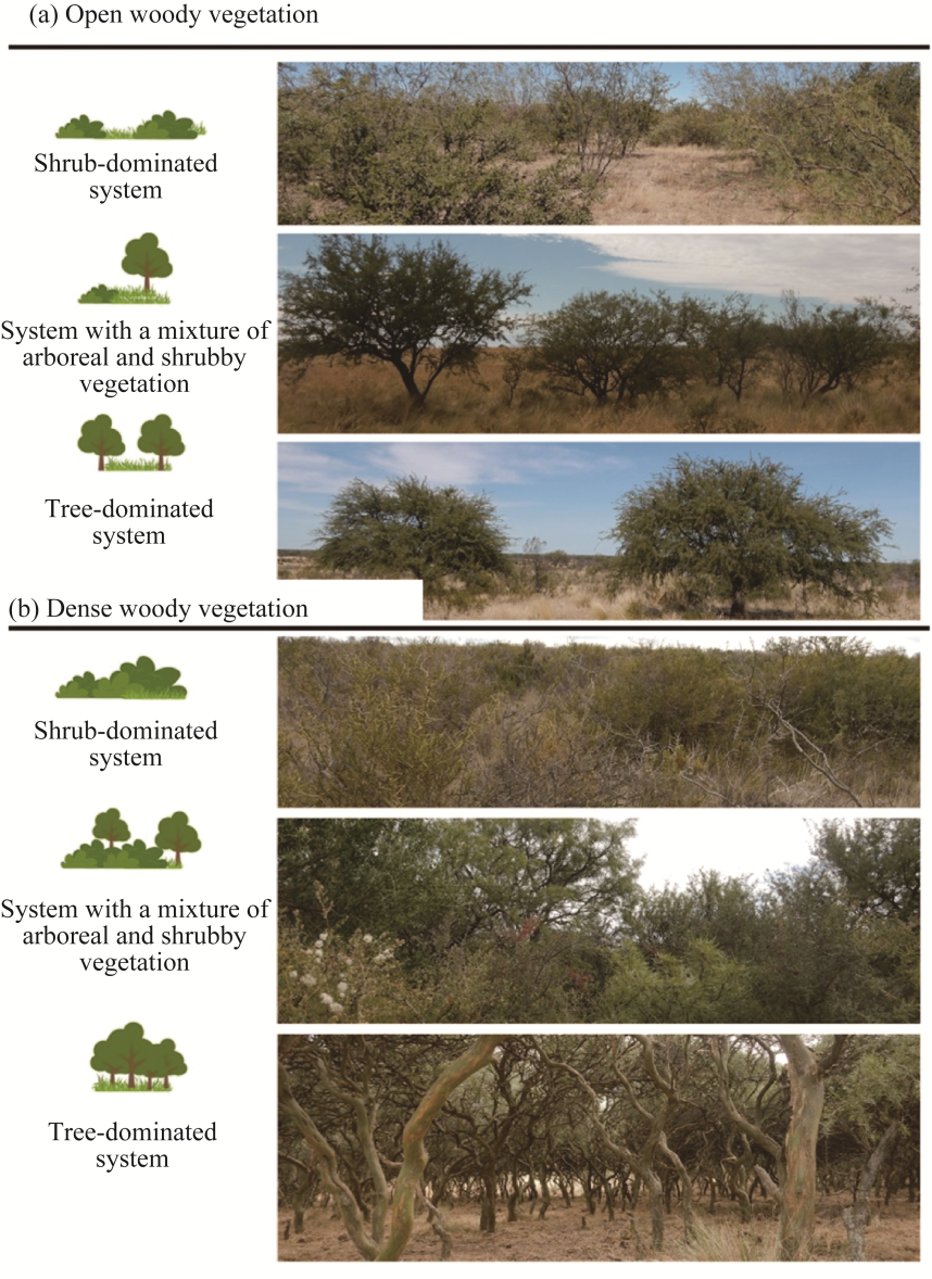
Fig. 2 Forest formations from open (a) to dense (b) woody vegetation structures. Both formations encompass shrub-dominated vegetation, mixed shrub-tree system, and tree-dominated system.
The climate is a semi-arid temperate transition type, characterized by warm summers and moderate winters (Godagnone and Bran, 2009). Annual average temperatures range from 18°C to 23°C from southeast to northwest. Rainfall varies along a southwest-northeast gradient, approximately ranging from 300 to 600 mm annually, with maxima in autumn and spring, and significant inter-annual variability (Godagnone and Bran, 2009).

2.2 Selection of fire and climate-related variables

For the fire-related variable, we used the TA database, commonly referred to as hotspots (Di Bella et al., 2011). The TA data indicate the probability of fire occurrence at a specific date and location (geolocation), as recorded by different sensors. Daily TA locations were obtained from the MODIS sensor (with a spatial resolution of 250 m×250 m) aboard the Terra platform (MOD14; Giglio et al., 2003), during the period from November 2000 to March 2020. The MODIS dataset was processed to filter out values with a confidence level higher than 65.0%, and to extract latitude, longitude, and date information. These data were then used to aggregate the occurrence data of TA monthly at different scales: ecoregion, provincial sectors, and localities. The MODIS active fire detection algorithms assign a confidence level to each detected pixel. The 65.0% threshold is defined by the product developers (Giglio et al., 2003) as the ''nominal'' or ''high confidence'' level. By filtering out the data that meet or exceed this threshold, product developers ensure that only detections with a low probability of being false positives (errors), such as warm surfaces unrelated to fires, are used.
These TA data were associated with climatic conditions that determine the spatial parameters of TA occurrence and with meteorological conditions that predict the degree of control of meteorological variables on TA occurrence. The study area has four meteorological stations, which have recorded climate data for roughly four decades, making it difficult to accurately characterize its climate. This situation is a recurrent challenge in different parts of the world, and therefore, we relied on sources of climatic and meteorological data derived from interpolations and models. In this context, the Worldclim climate data source (Fick and Hijmans, 2017) and the climatic research unit (CRU) meteorological data source (Harris et al., 2020) were deemed appropriate for the area. Other widely used meteorological sources, such as the Climate Hazards Group InfraRed Precipitation with Station (CHIRPS) (https://www.chc.ucsb.edu/data/chirp) and the ERA-5 (the fifth generation ECMWF (European Centre for Medium-Range Weather Forecasts) atmospheric reanalysis of the global climate) database (Hersbach et al., 2020) were also considered. However, the CRU database was selected because it yielded the best fits (R2>0.700) in comparison with different databases with real data from local meteorological stations. Although this indicator alone may not be the best descriptor of data quality, the CRU database provides a larger number of relevant variables and easy access to the data.
We used TA data from the last 20 a to determine spatial parameters and their relationship with climate data. For this purpose, using the Worldclim database (Fick and Hijmans, 2017), which provides the 30-a average data, we established rainfall isohyets and aridity index curves. The aridity index, an indicator of water availability based on Thorntwaite and Mather (1957), is also used by Food and Agriculture Organization of the United Nations (FAO, 2007) to classify lands. The index is calculated as the ratio of rainfall to potential evapotranspiration. Furthermore, these variables have yielded the best results as bioclimatic indicators in fire-related studies (Di Bella et al., 2006, 2011).
Additionally, to estimate the degree of control of meteorological variables on TA occurrence, we used the CRU grid-based meteorological database, which provides data on rainfall and potential evapotranspiration, with records available from 1901 to the present. Therefore, it is an appropriate source for the analysis of extensive time series. For this study, we used data from 1998 to 2020. The CRU TS (Time Series) v.4.05 dataset consists of monthly gridded fields based on observational monthly data derived from daily or sub-daily records from the National Meteorological Service and other external agencies, with a high resolution of 0.5°×0.5°.
Meteorological data were obtained using the Climate Explorer (http://climexp.knmi.nl/), developed by the World Meteorological Organization (WMO), a specialized agency of the United Nations dedicated to international cooperation and coordination on the state and behavior of the Earth's atmosphere. Using these data, we accessed the CRU database, the required variables (rainfall and potential evapotranspiration), and the geographical coordinates of the area. Monthly data for rainfall and potential evapotranspiration were integrated to create datasets for different temporal windows: wet months (April-November) and the average of two and three years preceding fire events. We selected these periods based on several bibliographic sources (Grau and Veblen, 2000; Grau, 2001; Di Bella et al., 2011).

2.3 Spatiotemporal fire patterns

To analyze the temporal patterns of TA, we integrated monthly data from 19 fire seasons between 2000 and 2020. We obtained cumulative TA values according to the seasons of the year: autumn (March-May), winter (June-August), spring (September-November), and summer (December- February). Using these data, descriptive analyses (Tukey, 1977) were conducted with the Infostat v.2016 software (Di Rienzo et al., 2016).
For the spatial patterns, a density map was created for the 19 fire seasons using a 10 km×10 km grid and applying the "kernel density estimation" algorithm. This algorithm is a non-parametric method that uses a Gaussian function to weigh the contribution of each point to the density based on distance. This algorithm allowed the calculation of TA concentration in the study area along the rainfall and aridity index climatic gradients. These procedures were performed using QGIS v.3.2 software. Additionally, for each provincial sector (Río Negro, La Pampa, and Buenos Aires), TA density was calculated as the number of TA divided by the area of each sector and multiplied by 1000. This standardization is essential for comparative analysis, especially when working with administrative or ecological units (e.g., ecoregions, provincial sectors, or localities) that inherently have heterogeneous surface areas.

2.4 Relationship between controlling factors and fire occurrence

To predict the occurrence of TAs in relation to climatic variables, we explored the relationship of TA in the summer with rainfall and aridity index variables obtained from meteorological data. These analyses were conducted for the different periods preceding fires (wet months, and two and three years preceding fire events). Only TA in the summer was considered because natural fires predominantly occur during this season, and it is highly unlikely that intentional fires for productive management purposes occur due to the extreme conditions in the summer (Busso, 1997).
The methods used in other areas of Argentina (Di Bella et al., 2011; Argañaraz et al., 2015) were followed, involving regressions between climatic variables from different periods and TA. The goodness-of-fit of each model was evaluated using R², the significance of each variable in the model was assessed using Student's t-values, and the predicted vs. observed plots were used to visually explore the linearity and homoscedasticity of the residuals. Based on these methods, we determined whether or not logarithmic transformations were necessary. These regressions were performed for the entire study area and for each provincial sector using Infostat v.2016 software (Di Rienzo et al., 2016).

3 Results

3.1 Spatiotemporal fire patterns

The summer season exhibited the highest cumulative count of TA (μ=500.70; σ=898.05) among the 19 fire seasons analyzed (Fig. 3a). This season also showed the greatest variability in TA between months, with January (μ=361.60; σ=675.11) and December (μ=139.60; σ=231.55) being the critical months with the highest cumulative TA values (Fig. 3b).
Fig. 3 Average cumulative count of thermal anomaly (TA) for different seasons (a) and months in the summer (b). Bars are standard deviations.
The occurrence of TA in the southern Espinal-Monte ecotone exhibited different spatial regional patterns in relation to annual rainfall and aridity index (Fig. 4). Regarding the average annual rainfall, the highest concentration of TA (55.0%) occurred in the 300-400 mm range. Sectors with an annual rainfall average below 300 mm exhibited 17.0% of TA, whereas sectors with an average annual rainfall above 400 mm accounted for 28.0% of TA (Fig. 4a). With respect to the aridity index, 64.5% of TA in the ecotone were found in sectors with intermediate values (0.3-0.4), forming a spatial distribution in the shape of an arc (Fig. 4b). The areas with the highest water deficit (aridity index<0.3) recorded 23.8% of TA. In contrast, the areas with the highest moisture levels (aridity index>0.4) accounted for 11.8% of TA (Fig. 4b).
Fig. 4 Relation of annual rainfall (a) and arid index (b) with TA density and its spatial distribution at provincial level (c)
Regarding the distribution of TA across different administrative sectors (provinces), a decrease in TA was observed toward the eastern area (Fig. 4c), with the following percentages: La Pampa accounted for 46.9% of TA, Río Negro accounted for 36.7% of TA, and Buenos Aires accounted for 16.4% of TA. The TA density per 1000 km2 exhibited a similar distribution pattern, with La Pampa being the sector with the highest average TA density per 1000 km2, while Buenos Aires showed the lowest average TA density per 1000 km2 (Fig. 5).
Fig. 5 Average density of TA per 1000 km2 in different provinces. Bars are standard deviations.

3.2 Relationship between controlling factors and fire occurrence

For the southern Espinal-Monte ecotone, the relationship between TA over the 19 fire seasons and the climatic variables—rainfall and aridity index—calculated for different periods showed strong fits (R2>0.700; Fig. 6). Regarding the aridity index for different periods (average aridity indices during wet months preceding fire events and the two and three year averages preceding TA count occurrence), the models with the best fit corresponded to the two years (R2=0.855) and months (R2=0.850) preceding fire events (Fig. 6a and c).
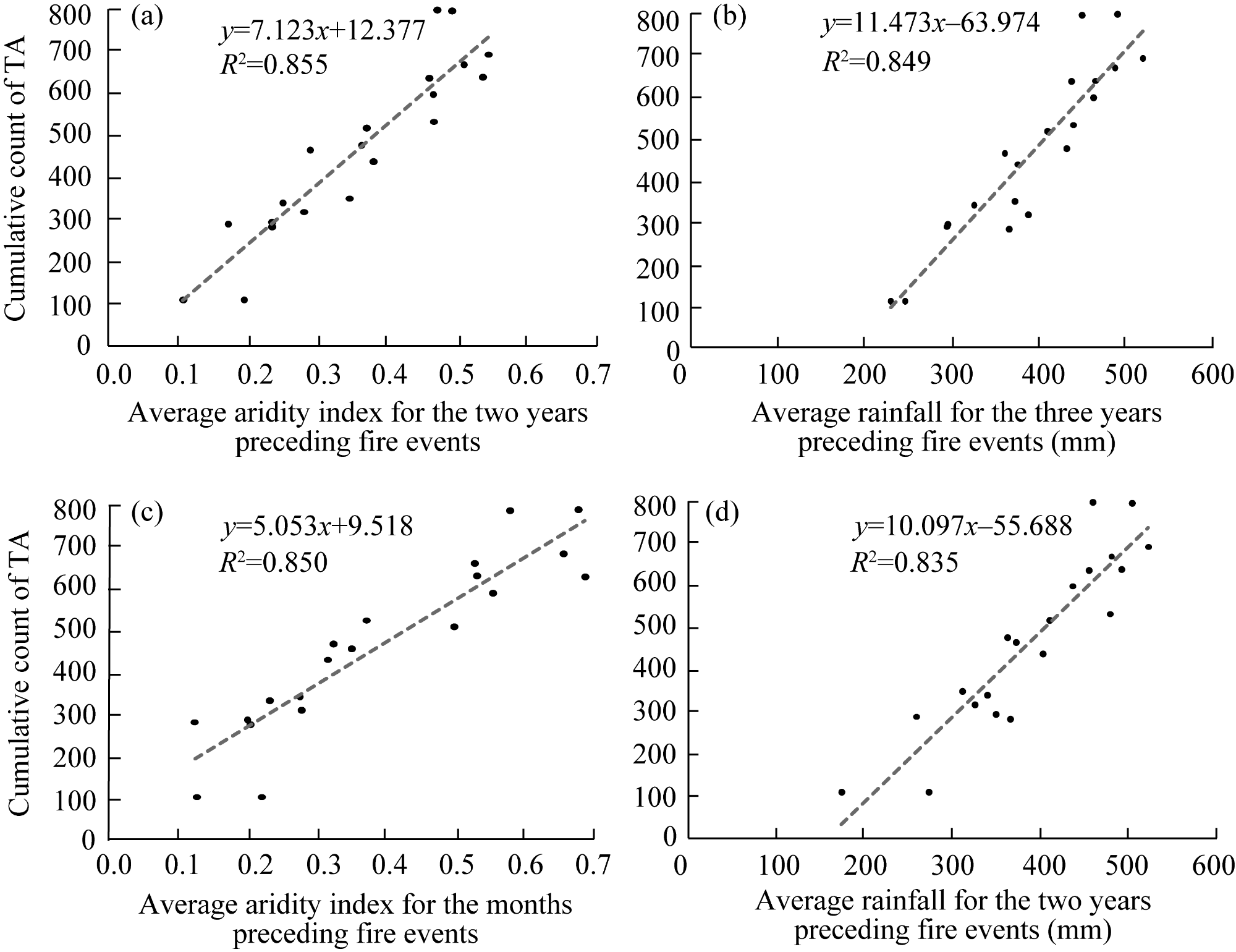
Fig. 6 Relationships between accumulative count of TA in the summer and climatic variables in the southern Espinal-Monte ecotone. (a), average aridity index for the two years preceding fire events; (b), average rainfall for the three years preceding fire events; (c), average aridity index for the months preceding fire events; (d), average rainfall for the two years preceding fire events.
For the rainfall variable (average rainfall for the two and three years preceding fire events), the best-fitting models were also found for the three (R2=0.849) and two years (R2=0.835) average rainfall (Fig. 6b and d).
When these relationships were analyzed by provincial sectors, all models also showed R2 above 0.700. In Río Negro, the best-fitting model (R2=0.843) was the one associating TA count with the average rainfall for the three years preceding fire events (Fig. 7a). In La Pampa, the best-fitting model was associated with the average aridity index of the months preceding fire events (R2=0.801, Fig. 7b). In Buenos Aires, the model yielded a lower R2 than those from the other provincial sectors, and was associated with average rainfall for the three years preceding fire events (R2=0.755; Fig. 7c).
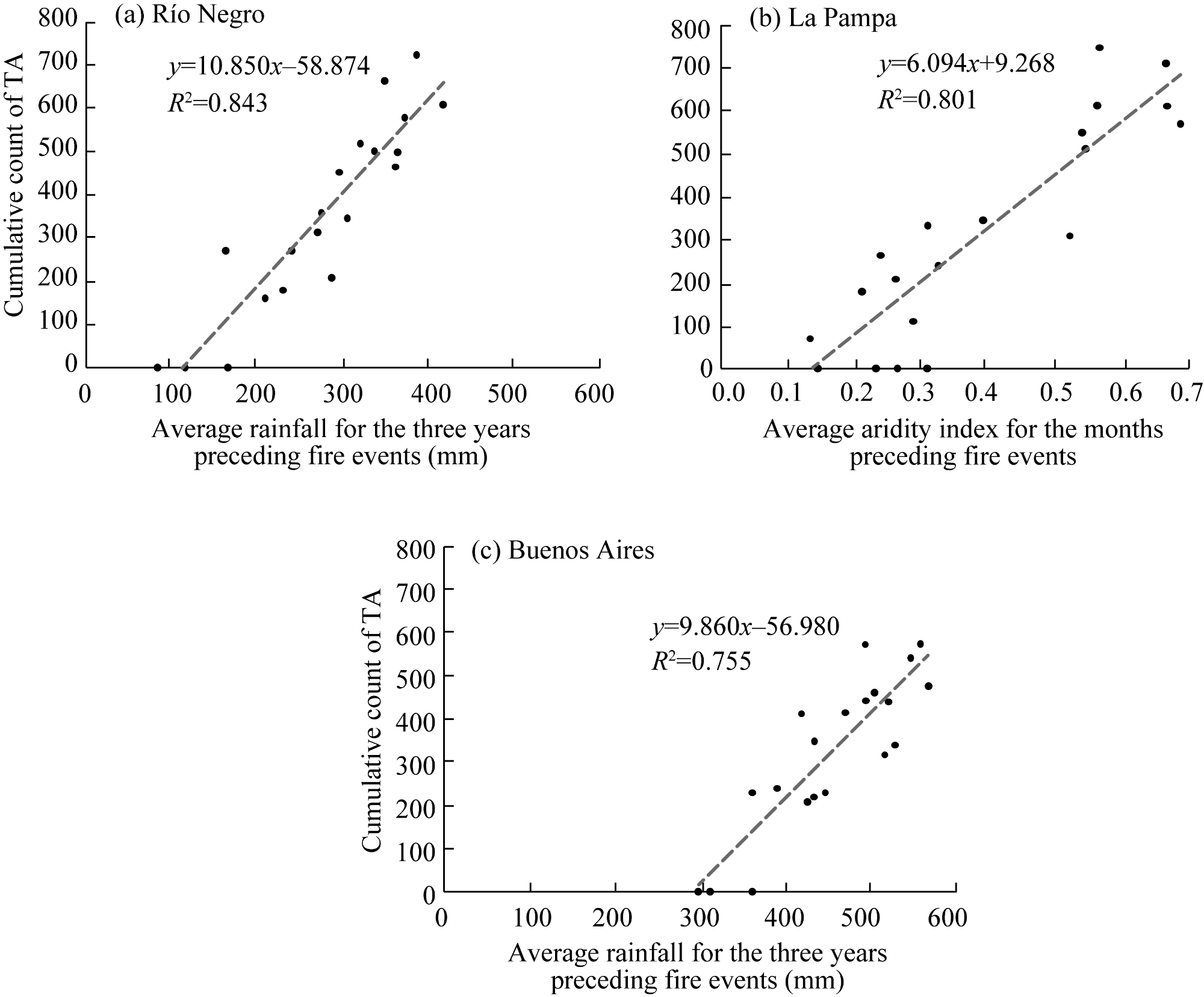
Fig. 7 Relationships between cumulative count of TA in the summer and climatic variables in different provinces. (a), average rainfall for the three years preceding fire events in Río Negro; (b), average aridity index of the months preceding fire events in La Pampa; (c), average rainfall for the three years preceding fire events in Buenos Aires.

4 Discussion

4.1 Spatiotemporal patterns of fires and their relationship with climate

Remote sensing technologies provide valuable information that can help explain fire behavior and its temporal and spatial variation in relation to climatic variables (Di Bella et al., 2011). In terms of temporal variation in the study area, the highest occurrence of TA was recorded in December and January, which may be considered as the critical months (Fig. 3). This pattern is consistent with the findings reported by Cavallero et al. (2023) and Sánchez et al. (2023) for the Caldenal region of the Espinal, Argentina, where the peak fire season extends from November to February. However, these results differ from those reported by Argañaraz et al. (2015) for the other semi-arid areas of Argentina, such as the Sierras of Córdoba (phytogeographic region of the Chaco Serrano, according to Cabrera (1976)), where most fires occur in August and September, with the fire season extending from July to early December. Additionally, our findings regarding the timing of fire occurrences differ from observations in the semi-arid center of Argentina—a region characterized by a mosaic of grasslands, shrublands, and dry forests—where fire events have been primarily recorded during late winter and early spring in the Southern Hemisphere (August-November) (Fischer et al., 2012).
Summer fires in the Southern Hemisphere are considered natural wildfires within the Monte phytogeographic province, as they typically occur under hot, dry, and windy climatic conditions and may have undesirable effects on the ecosystem (Busso, 1997). Although prescribed burns of moderate intensity are practiced in the area, they are generally scheduled for the autumn and spring seasons of the Southern Hemisphere, when moisture, temperature, and wind conditions can be more easily controlled (Peláez et al., 2010). These prescribed burns can help manage woody plant encroachment, increase forage production, and facilitate livestock management (Kröpfl et al., 2015). However, current regulations regarding native forest protection in the provinces of La Pampa and Buenos Aires prohibit this type of management.
In the southern Espinal-Monte ecotone, our results indicate that the distribution of TA (fire hotspots) is primarily linked to average annual rainfall levels between 300 and 400 mm (55.0%). Furthermore, the highest concentration of fire activity (64.5%) was associated with an aridity index between 0.3 and 0.4, forming a fire arc-like distribution in the central zone of this ecotone (Fig. 4). This finding is consistent with the spatial variation observed across the country. Preliminary results by Peinetti et al. (2024), based on MODIS sensors, previously revealed that over the past 20 a, fire activity has spread in an arc-like pattern across central and northern Argentina, including the southern Espinal-Monte ecotone. This broader distribution is associated with a wide range of climatic conditions, including average annual rainfall of 250-1800 mm, average annual temperature of 13°C-25°C, and water deficits of 100-1300 mm.
The central zone of the study area—encompassing La Pampa and Río Negro provinces—showed the highest density of fire hotspots. In 2021, this area also exhibited the highest percentage of woody aboveground biomass (approximately 70.0% cover) (Rodríguez et al., 2021), and extensive livestock grazing is the main pattern of land uses (Kröpfl et al., 2015; Zeberio et al., 2018). Similar findings were reported by Sánchez et al. (2023), who studied fire events in La Pampa and found that the most affected vegetation types were xerophytic woodlands, followed—though to a lesser extent—by Neltuma forests and psammophilous steppes and shrublands.
The estimated fire density, both by ecological unit and by provincial sector, showed a marked decline toward the eastern part of the area, specifically in SW Buenos Aires Province. This area had a low woody vegetation cover in 2010 (21.0%) (Torres Robles and Rodríguez, 2023), and approximately 60.0% of its surface is devoted to rainfed grain crops (Gaspari et al., 2021). In this regard, several studies comparing the number of fires in natural vegetation areas and agricultural zones have found that fire activity is more frequent in areas of natural vegetation, primarily grasslands and shrublands (Argañaraz et al., 2015; Fischer et al., 2015). Furthermore, other studies in semi-arid area have shown that the expansion of agricultural land tends to reduce fire density (Di Bella et al., 2006). Therefore, the decreasing trend in fire density toward the eastern study area may be attributed not only to climatic factors, such as changes in the aridity index, but also to land-use changes associated with agricultural expansion.

4.2 Relationship between controlling factors and fire occurrence

Several studies have demonstrated a cyclic pattern in fire events, influenced by previous meteorological conditions or by biomass regeneration after a severe event (Di Bella et al., 2011; Ullah et al., 2013; Gueguim et al., 2018; Yin et al., 2021; Zoffoun et al., 2023). In the southern Espinal-Monte ecotone, an ecosystem characterized by oscillations between wet and dry precipitation cycles (Bohn et al., 2011; Gabella and Campo, 2016), fire occurrence is closely associated with climatic conditions from previous years. We found strong correlations of the accumulated number of TA with rainfall and aridity index values from preceding seasons. These climatic variables serve as key indicators of water availability, linking the accumulation of fine biomass with fires during subsequent dry months, particularly in ecosystems with cyclic rainfall patterns.
Our results, which identify rainfall and aridity indices as key controls of fire activity, are consistent with findings from other studies conducted in semi-arid or seasonally dry areas. For example, Di Bella et al. (2011) found that the aridity index was a strong predictor of TA in semi-arid ecosystems of northern Argentina. Other studies in the semi-arid Chaco (Bravo et al. 2010), the Yungas (Aráoz and Grau, 2010), northeastern Argentina (Grau and Veblen, 2000), and La Pampa (Sánchez et al., 2023) also highlight that increased fire activity follows periods of elevated rainfall or favorable water balance, which are then succeeded by a dry phase. Although correlations did not improve when analyzed by provincial sectors—suggesting that climatic conditions affect vegetation units at a landscape scale—we did observe variations in TA density between provinces, which could be linked to their land-use history.
Our findings suggest that fuel availability is a critical limiting factor for fire occurrence within the study area. However, land-use dynamics driven by human activities are equally important and warrant additional investigation to understand the spatial patterns of fires. The predominant production models in each province directly influence vegetation dynamics and fire density. In La Pampa and Río Negro, livestock grazing is the predominant land use type, while in Buenos Aires, it coexists with vast agricultural areas. Grazing pressure from livestock can serve as a key anthropogenic control by consuming fine fuels, offering a strategy to mitigate wildfire risk through strategic management of additional forage. In contrast, agricultural expansion tends to reduce fire density by transforming native vegetation into crops with lower fuel continuity and availability (Di Bella et al., 2011).
Furthermore, climate change introduces additional complexity into long-term fire dynamics, making its incorporation crucial in future studies (IPCC, 2019). Sustainable management of forest systems is essential for climate change mitigation and adaptation (Gaspari et al., 2021; Torres Robles and Rodríguez, 2023). Specifically, in the northeastern part of southern Espinal-Monte ecotone, climate models project an increase in rainfall (IPCC, 2019). While the increase in rainfall could enhance biomass production, it also contributes to a concerning trend, i.e., the growing rural-to-urban migration (Sili, 2019). This migration implies a progressive decrease in animal stocking rates, which would reduce grazing as a fuel control mechanism. In this scenario, fire cycles are likely to become increasingly intense and uncontrolled due to the accumulation of fine biomass without proper management.
This potential scenario prompts reflection on the reaction speed of livestock farming, as adjusting animal stocking rates from one year to the next is not easy. Therefore, proactive management of fine fuel—through planned grazing or prescribed burns—becomes crucial (Christopher, 2024). By identifying a "window" of one or two years related to rainfall pulses, our results offer valuable temporal leverage for managing this control, thus preventing large fires, such as those that frequently occur in the area (Cavallero et al., 2023). In this regard, the role of human activities, particularly agriculture and grazing, is crucial for future studies, given their impact on the structure and continuity of fine fuel and, consequently, on fire regimes.

5 Conclusions

Fires in the southern Espinal-Monte ecotone exhibit a defined seasonal pattern, with peak activity between December and January. This result aligns with the high fire season in the Caldenal area, which spans from November to February, but differs from other semi-arid areas of Argentina. Geographically, the central zone—La Pampa and Río Negro—shows the highest density of fire hotspots. These areas, characterized by approximately 70.0% woody biomass cover and extensive livestock grazing, is associated with annual rainfall of 300-400 mm and an aridity index of 0.3-0.4, forming a distinct "fire arc". Conversely, fire density decreases sharply eastward in Buenos Aires, where low woody vegetation cover (21.0%) and 60.0% dryland crops suggest that agricultural expansion reduces fire incidence by converting native vegetation into landscapes with less fuel. In summary, both climate and land use are crucial factors for understanding fire patterns in the area.

Conflict of interest

The authors declare that they have no known competing financial interests or personal relationships that could have appeared to influence the work reported in this paper.

Acknowledgments

This research was funded by the National University of Río Negro Research Project (40-C-658). This work is part of PhD Dissertation of Dr. Laura B RODRÍGUEZ.

Author contributions

Conceptualization: Laura B RODRÍGUEZ, Silvia S TORRES-ROBLES, Néstor I GASPARRI; Methodology: Laura B RODRÍGUEZ; Formal analysis: Laura B RODRÍGUEZ; writing - original draft preparation: Laura B RODRÍGUEZ; Writing - review and editing: Laura B RODRÍGUEZ, Silvia S TORRES-ROBLES, Néstor I GASPARRI; Funding acquisition: Silvia S TORRES-ROBLES; Resources: Silvia S TORRES-ROBLES; Supervision: Laura B RODRÍGUEZ, Silvia S TORRES-ROBLES, Néstor I GASPARRI. All authors approved the manuscript.
[1]
Aráoz E, Grau H R. 2010. Fire-mediated forest encroachment in response to climatic and land-use change in subtropical Andean tree lines. Ecosystems, 13: 992-1005.

DOI

[2]
Argañaraz J P, Gavier-Pizarro G, Zak M, et al. 2015. Fire regime, climate, and vegetation in the Sierras de Córdoba, Argentina. Fire Ecology, 11(1): 55-73.

DOI

[3]
Bohn V, Piccolo C, Perillo G. 2011. Analysis of dry and wet periods in southwestern Buenos Aires Province (Argentina). Journal of Climatology, 11: 31-43. (in Spanish)

[4]
Bran D E, Cecchi G A, Gaitán J J, et al. 2007. Effect of burn severity on vegetation regeneration in the Southern Monte. Austral Ecology (Argentina), 17: 123-131. (in Spanish)

[5]
Bravo S, Kunst C, Grau R, et al. 2010. Fire-rainfall relationships in Argentine Chaco savannas. Journal of Arid Environments, 74(10): 1319-1323.

DOI

[6]
Busso C A. 1997. Towards an increased and sustainable production in semiarid rangelands of Central Argentina: Two decades of research. Journal of Arid Environments, 36(2): 197-210.

DOI

[7]
Cabrera A L. 1976. Phytogeographical Regions of Argentina. (2nd ed.). Buenos Aires: Argentine Encyclopedia of Agriculture and Gardening. (in Spanish)

[8]
Cavallero L, Peinetti R, Lopez D R. 2023. Incidence of fires in Argentina during the last two decades and its association with land cover and use in different environmental contexts. Austral Ecology (Argentina), 33: 773-797. (in Spanish)

[9]
Chuvieco E. 2009. Earth Observation of Wildland Fires in Mediterranean Ecosystems. Heidelberg: Springer.

[10]
Christopher L S, Eva K S, Karen L L, et al. 2024. Targeted cattle grazing to alter fuels and reduce fire behavior metrics in shrub-grasslands. Rangeland Ecology & Management, 96: 105-116.

DOI

[11]
Di Bella C M, Jobbágy E G, Paruelo J M, et al. 2006. Continental fire density patterns in South America. Global Ecology and Biogeography, 15(2): 192-199.

DOI

[12]
Di Bella C M, Fischer M A, Jobbágy E G. 2011. Fire patterns in north-eastern Argentina: Influences of climate and land use/cover. International Journal of Remote Sensing, 32(17): 4961-4971.

DOI

[13]
Di Bella C M, Posse G. 2014. Fire study and monitoring. Remote sensing and geographic information systems. Their applications in agricultural and environmental sciences. In: Paruelo J M, Di Bella C M, Milkovic M. Remote Sensing and Geographic Information System:Their Applications in Agricultural and Environmental Sciences. Capital Federal: Southern Hemisphere Publishing House. (in Spanish)

[14]
Di Rienzo J A, Casanoves F, Balzarini M G, et al. 2016. InfoStat Version 2016. InfoStat Group, FCA, National University of Córdoba, Argentina.

[15]
FAO (Food and Agriculture Organization of the United Nations). 2007. Land evaluation: Towards a revised framework. Roma, Italy. [2025-04-19]. ftp://ftp.fao.org/docrep/fao/011/a1080e/a1080e00.pdf.

[16]
Fick S E, Hijmans R J. 2017. WorldClim 2: New 1-km spatial resolution climate surfaces for global land areas. International Journal of Climatology, 37(12): 4302-4315.

DOI

[17]
Fischer M A, Di Bella C M, Jobbágy E G. 2012. Fire patterns in central semiarid Argentina. Journal of Arid Environments, 78: 161-168.

DOI

[18]
Fischer M A, Di Bella C M, Jobbágy E G. 2015. Influence of fuel conditions on the occurrence, propagation and duration of wildland fires: A regional approach. Journal of Arid Environments, 120: 63-71.

DOI

[19]
Fosberg F R. 1961. Classification of vegetation for general purposes. Tropical Ecology, 2: 1-28.

[20]
Gabella J, Campo A M. 2016. Environmental fragility and degradation in rural areas of Argentina's temperate arid diagonal. Geographical Studies, 77(281): 491-519. (in Spanish)

[21]
Gaspari F J, Goya J, Arturi M, et al. 2021. Environmental and socioeconomic assessment of forest watersheds: Puan-Villarino-Patagones Forest Watershed, Province of Buenos Aires. In: Final Consulting Report. Ministry of Environment and Sustainable Development, Innova-T Foundation, La Plata, Argentina. (in Spanish)

[22]
Giglio L, Descloitres J, Justice C O, et al. 2003. An enhanced contextual fire detection algorithm for MODIS. Remote Sensing of Environment, 87(2-3): 273-282.

DOI

[23]
Godagnone R E, Bran D E. 2009. Integrated inventory of the natural resources of the province of Río Negro. Geology, hydrogeology, geomorphology, soils, vegetation, and fauna. INTA Editions. Buenos Aires, Argentina. (in Spanish)

[24]
Grau H R, Veblen T T. 2000. Rainfall variability, fire and vegetation dynamics in neotropical montane ecosystems in north-western Argentina. Journal of Biogeography, 27(5): 1107-1121.

DOI

[25]
Grau H R. 2001. Regional-scale spatial patterns of fire in relation to rainfall gradients. Global Ecology and Biogeography, 10(2): 133-146.

DOI

[26]
Gueguim C D, Tchamba N M, Fotso C R. 2018. Dynamic of spatial distribution of forest fire in the Mbam and Djerem Conservation Region (Cameroun). International Journal of Biological and Chemical Sciences, 12(2): 728-748. (in French)

DOI

[27]
Harris I, Timothy T J, Jones P, et al. 2020. Version 4 of the CRU TS monthly high-resolution gridded multivariate climate dataset. Scientific Data, 7: 109, doi: 10.1038/s41597-020-0453-3.

PMID

[28]
Hersbach H, Bell B, Berrisford P, et al. 2020. The ERA 5 global reanalysis. Quarterly Journal of the Royal Meteorological Society, 146(730): 1999-2049.

DOI

[29]
IPCC (Intergovernmental Panel on Climate Change). 2019. Summary for policymakers. In: Shukla P R, Skea J, Calvo B, et al. Climate Change and Land: An IPCC Special Report on Climate Change, Desertification, Land Degradation, Sustainable Land Management, Food Security, and Greenhouse Gas Fluxes in Terrestrial Ecosystems. Cambridge: Cambridge University Press.

[30]
Kröpfl A I, Deregibus V A, Cecchi G A. 2015. A state and transition model for the eastern Monte Phytogeographycal Province in Río Negro. Phyton, 84(2): 390-396.

DOI

[31]
Pausas J G, Keeley J E. 2021. Wildfires and global change. Frontiers in Ecology and the Environment, 19(7): 387-395.

DOI

[32]
Peinetti H R, Bestelmeyer B T, Chirino C C, et al. 2024. Thresholds and alternative states in a neotropical dry forest in response to fire severity. Bulletin, 1054(2): e02130, doi: 10.1002/bes2.2130.

[33]
Peláez D V, Giorgetti H D, Montenegro O A, et al. 2010. Vegetation response to a controlled fire in the Phytogeographical Province of the Monte, Argentina. Phyton, 79: 169-176.

DOI

[34]
Peter G, Funk F A, Torres Robles S S. 2013. Responses of vegetation to different land-use histories involving grazing and fire in the North-east Patagonian Monte, Argentina. The Rangeland Journal, 35(3): 273-283.

DOI

[35]
Rodríguez L B, Torres Robles S S, Arturi M F, et al. 2021. Plant cover as an estimator of above-ground biomass in semi-arid woody vegetation in Northeast Patagonia, Argentina. Journal of Arid Land, 13(9): 918-933.

DOI

[36]
Rollins M G, Morgan P, Swetnam T. 2002. Landscape-scale controls over 20th century fire occurrence in two large Rocky Mountain (USA) wilderness areas. Landscape Ecology, 17: 539-557.

DOI

[37]
Sánchez M, Baldassini P, Fischer M, et al. 2023. Where, when, and how large fires occur in La Pampa Province, Argentina: A remote sensing-based characterization. Austral Ecology (Argentina), 33(1): 211-228. (in Spanish)

[38]
Sankarán M, Anderson T M. 2009. Management and restoration in African Savannas:Interactions and feedbacks. In: Hobbs RJ, Suding KN. New Models for Ecosystem Dynamics and Restoration. Washington D. C.: Island Press, 136-155.

[39]
Sharples J J. 2009. An overview of mountain meteorological effects relevant to fire behaviour and bushfire risk. International Journal of Wildland Fire, 18(7): 737-754.

DOI

[40]
Sili M E. 2019. Urban-to-rural migration in Argentina: A case study-based characterization. Population and Society, 26(1): 90-119. (in Spanish).

[41]
Takacs S, Bühne H S, Pettorelli N. 2021. What shapes fire size and spread in African savannahs? Remote Sensing in Ecology and Conservation, 7(4): 610-620.

DOI

[42]
Thorntwaite C W, Mather J R. 1957. Instructions and tables for computing the potential evapotranspiration and water balance. Laboratory of Climatology, 10: 185-311.

[43]
Torres Robles S S, Arturi M, Contreras C, et al. 2015. Geographic variations in the structure and composition of woody vegetation at the boundary between the Espinal and the Monte in northeastern Patagonia (Argentina). Bulletin of the Argentine Botanical Society, 50(2): 209-215. (in Spanish)

[44]
Torres Robles S S, Rodríguez L B. 2023. Characterization and distribution of woody communities in the southern ecotone of Espinal-Monte, Argentina. Austral Ecology (Argentina), 33: 641-657. (in Spanish)

[45]
Tukey J W. 1977. Exploratory Data Analysis. Boston: Addison-Wesley Publishing Company.

[46]
Ullah M R, Liu X D, Al-Amin M. 2013. Spatial-temporal distribution of forest fires and fire weather index calculation from 2000 to 2009 in China. Journal of Forest Science, 59(7): 279-287.

DOI

[47]
van der Werf G R, Randerson J T, Giglio L, et al. 2008. Climate controls on the variability of fires in the tropics and subtropics. Global Biogeochemical Cycles, 22(3): GB3028, doi: 10.1029/2007GB003122.

[48]
Villagra P E, Defossé G E, del Valle H F, et al. 2009. Land use and disturbance effects on the dynamics of natural ecosystems of the Monte Desert: Implications for their management. Journal of Arid Environments, 73(2): 202-211.

DOI

[49]
Whelan R J. 1995. The Ecology of Fire. Cambridge: Cambridge University Press.

[50]
Winschel C, Pezzola A, Casella A. 2022. Dynamics of land cover and land use changes. In: National Institute of Agricultural Technology (INTA). Technical Report 79, Hilario Ascasubi Agricultural Experiment Station. Hilario Ascasubi, Argentina.

[51]
Yin H M, Guli J, Jiang L L, et al. 2021. Monitoring fire regimes and assessing their driving factors in Central Asia. Journal of Arid Land, 13(5): 500-515.

DOI

[52]
Zacconi G, Toppazzini M. 2018. Areas affected by forest and rural fires in the Pampas and northeastern Patagonian region during the 2016-2017 season. In: Technical Report. Ministry of Environment and Sustainable Development (MESD). Chubut, Argentina. (in Spanish)

[53]
Zeberio J M, Torres Robles S, Calabrese G. 2018. Land use and conservation status of the woody vegetation of the Monte in the Northeast of Patagonia. Austral Ecology (Argentina), 28: 543-552. (in Spanish)

[54]
Zoffoun O G, Djagoun C A M S, Sogbohossou E A. 2023. Distribution patterns of fire regime in the Pendjari Biosphere Reserve, West Africa. Journal of Arid Land, 15(10): 1160-1173.

DOI

[55]
Zoffoun O G, Djagoun C A M S, Nguyen T T, et al. 2024. Understanding fire intensity in the Sudanian savannah of Western Africa: Implications for sustainable fire management. African Journal of Ecology, 62(2): e13278, doi: 10.1111/aje.13278.

Outlines

/