
Characterization of alpine meadow surface crack and its correlation with root-soil properties
Received date: 2024-02-03
Revised date: 2024-05-23
Accepted date: 2024-06-04
Online published: 2025-08-13
Quantifying surface cracks in alpine meadows is a prerequisite and a key aspect in the study of grassland crack development. Crack characterization indices are crucial for the quantitative characterization of complex cracks, serving as vital factors in assessing the degree of cracking and the development morphology. So far, research on evaluating the degree of grassland degradation through crack characterization indices is rare, especially the quantitative analysis of the development of surface cracks in alpine meadows is relatively scarce. Therefore, based on the phenomenon of surface cracking during the degradation of alpine meadows in some regions of the Qinghai-Tibet Plateau, we selected the alpine meadow in the Huangcheng Mongolian Township, Menyuan Hui Autonomous County, Qinghai Province, China as the study area, used unmanned aerial vehicle (UAV) sensing technology to acquire low-altitude images of alpine meadow surface cracks at different degrees of degradation (light, medium, and heavy degradation), and analyzed the representative metrics characterizing the degree of crack development by interpreting the crack length, length density, branch angle, and burrow (rat hole) distribution density and combining them with in situ crack width and depth measurements. Finally, the correlations between the crack characterization indices and the soil and root parameters of sample plots at different degrees of degradation in the study area were analyzed using the grey relation analysis. The results revealed that with the increase of degradation, the physical and chemical properties of soil and the mechanical properties of root-soil composite changed significantly, the vegetation coverage reduced, and the root system aggregated in the surface layer of alpine meadow. As the degree of degradation increased, the fracture morphology developed from "linear" to "dendritic", and eventually to a complex and irregular "polygonal" pattern. The crack length, width, depth, and length density were identified as the crack characterization indices via analysis of variance. The results of grey relation analysis also revealed that the crack length, width, depth, and length density were all highly correlated with root length density, and as the degradation of alpine meadows intensified, the underground biomass increased dramatically, forming a dense layer of grass felt, which has a significant impact on the formation and expansion of cracks.
WU Yuechen , ZHU Haili , ZHANG Yu , ZHANG Hailong , LIU Guosong , LIU Yabin , LI Guorong , HU Xiasong . Characterization of alpine meadow surface crack and its correlation with root-soil properties[J]. Journal of Arid Land, 2024 , 16(6) : 834 -851 . DOI: 10.1007/s40333-024-0100-5
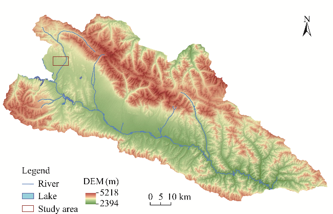
Fig. 1 Location of the study area in Huangcheng Mongolian Township, Menyuan Hui Autonomous County. DEM, digital elevation model. |
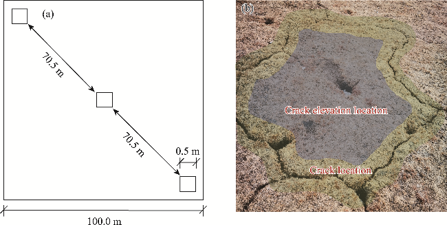
Fig. 2 Schematic diagram of large-scale and small-scale sample plots (a) and sampling position (b) |
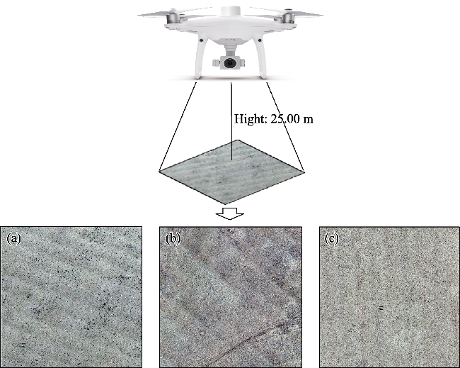
Fig. 3 Digital orthophoto maps (DOM) of large-scale alpine meadow sample plot. (a), light degradation (LD) sample plot; (b), moderate degradation (MD) sample plot; (c), heavy degradation (HD) sample plot. |
Table 1 Soil characteristics of the three alpine meadow sample plots at different degrees of degradation |
| Sample plot | Sampling position | Layer depth (cm) | Soil moisture content (%) | Soil density (g/cm3) | Soil compactness (kPa) | Fine grain content (%) | Organic matter content (g/kg) |
|---|---|---|---|---|---|---|---|
| LD | Crack location | 0-10 | 42.84 | 1.06 | 426.30 | 11.19 | 151.50 |
| 10-20 | 35.00 | 1.20 | 306.82 | 10.23 | 111.25 | ||
| 20-30 | 28.95 | 1.08 | 325.78 | 9.16 | 98.31 | ||
| Crack elevation location | 0-10 | 38.66 | 0.98 | 970.99 | 7.93 | 130.05 | |
| 10-20 | 28.66 | 1.18 | 574.55 | 13.36 | 100.07 | ||
| 20-30 | 25.13 | 1.14 | 612.46 | 14.95 | 92.64 | ||
| MD | Crack location | 0-10 | 46.73 | 0.85 | 589.50 | 7.67 | 209.65 |
| 10-20 | 37.70 | 1.31 | 413.69 | 12.63 | 106.41 | ||
| 20-30 | 35.66 | 1.20 | 465.40 | 13.04 | 72.08 | ||
| Crack elevation location | 0-10 | 43.14 | 0.98 | 1299.64 | 14.19 | 145.71 | |
| 10-20 | 32.91 | 1.20 | 772.21 | 15.72 | 86.65 | ||
| 20-30 | 29.63 | 1.03 | 730.84 | 12.85 | 67.56 | ||
| HD | Crack location | 0-10 | 62.65 | 0.90 | 405.60 | 10.11 | 170.34 |
| 10-20 | 48.78 | 1.23 | 275.79 | 18.98 | 104.74 | ||
| 20-30 | 44.75 | 1.18 | 234.42 | 17.58 | 99.79 | ||
| Crack elevation location | 0-10 | 61.09 | 1.00 | 973.33 | 8.69 | 126.90 | |
| 10-20 | 47.06 | 1.38 | 417.73 | 22.84 | 105.72 | ||
| 20-30 | 37.39 | 1.16 | 391.83 | 12.55 | 70.60 |
Note: LD, light degradation; MD, moderate degradation; HD, heavy degradation. |
Table 2 Vegetation species and coverage in the three sample plots at different degrees of degradation |
| Sample plot | Total vegetation coverage (%) | Number of families | Number of species | Coverage of Cyperaceae and Gramineae plants (%) | Dominant plant species |
|---|---|---|---|---|---|
| LD | 92.00-100.00 | 8 | 18 | 63.00 | Kobresia pygmaca, Elymus nutans, Stipa capillata, and Oxytropis kansuensis |
| MD | 75.00-88.00 | 8 | 14 | 41.00 | Kobresia pygmaca, Kobresia humilis, Anaphalis hancockii, and Gentiana macrophylla |
| HD | 50.00-65.00 | 6 | 10 | 26.00 | Kobresia humilis, Stipa capillata, Saussurea pulchra, and Leontopodium leontopodioides |
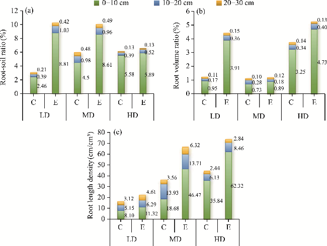
Fig. 4 Root-soil ratio (a), root volume ratio (b), and root length density (c) at different soil depth layers in the three alpine meadow sample plots at different degrees of degradation. C, crack location; E, crack elevation location. |
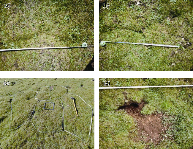
Fig. 5 Fracture morphology in alpine meadows. (a), linear fracture; (b), dendritic fracture; (c) polygonal fracture; (d), rat hole and surrounding bare ground. |
Table 3 Statistic result of fracture characterization parameter in the three alpine meadow sample plots at different degrees of degradation |
| Fracture characterization parameter | Alpine meadow sample plot at different degrees of degradation | ||
|---|---|---|---|
| LD | MD | HD | |
| Crack length (m) | 2.22±1.63a | 2.26±1.89a | 1.66±1.24b |
| Crack width (cm) | 13.11±6.12a | 10.40±6.49b | 8.10±3.55c |
| Crack depth (cm) | 3.99±1.20b | 4.88±1.73a | 5.40±1.84a |
| Crack length density (m/m2) | 0.20 | 0.22 | 0.27 |
| Burrow distribution density (number/m2) | 0.002 | 0.061 | 0.231 |
| Crack branch angle (°) | 30-110 | 50-100 | 30-70 |
| Fracture morphology | Linear type | Dendritic type | Polygonal type |
Note: ±, mean±SD. Different lowercase letters within the same row represent significant difference at P<0.05 level. |
Table 4 Correlation between basic characteristics of vegetation and soil and crack characterization indices |
| Reference factor | Sampling position | Comparative factor | ||||||||
|---|---|---|---|---|---|---|---|---|---|---|
| Soil physical property | Soil mechanical property | Soil chemical property | Root parameter | |||||||
| Soil moisture content | Soil density | Fine grain content | Soil compactness | Organic matter content | Root-soil ratio | Root volume ratio | Root length density | |||
| Crack length | Crack location | 0.56 | 0.74 | 0.68 | 0.61 | 0.61 | 0.72 | 0.80 | 0.82 | |
| Crack elevation location | 0.62 | 0.76 | 0.62 | 0.70 | 0.50 | 0.83 | 0.83 | 0.89 | ||
| Crack width | Crack location | 0.74 | 0.65 | 0.62 | 0.69 | 0.67 | 0.61 | 0.66 | 0.72 | |
| Crack elevation location | 0.78 | 0.78 | 0.72 | 0.63 | 0.64 | 0.80 | 0.80 | 0.87 | ||
| Crack depth | Crack location | 0.76 | 0.72 | 0.67 | 0.69 | 0.66 | 0.66 | 0.72 | 0.78 | |
| Crack elevation location | 0.72 | 0.79 | 0.69 | 0.65 | 0.63 | 0.81 | 0.82 | 0.88 | ||
| Crack length density | Crack location | 0.74 | 0.69 | 0.62 | 0.67 | 0.66 | 0.62 | 0.68 | 0.72 | |
| Crack elevation location | 0.74 | 0.82 | 0.68 | 0.65 | 0.61 | 0.81 | 0.81 | 0.88 | ||
| [1] |
|
| [2] |
|
| [3] |
|
| [4] |
|
| [5] |
|
| [6] |
|
| [7] |
|
| [8] |
|
| [9] |
|
| [10] |
|
| [11] |
|
| [12] |
|
| [13] |
|
| [14] |
|
| [15] |
|
| [16] |
|
| [17] |
|
| [18] |
|
| [19] |
|
| [20] |
|
| [21] |
|
| [22] |
Ministry of Housing and Urban-Rural Development of the People's Republic of China. 2019. Standard for Geotechnical Testing Method (GB/T50123-2019). [2024-01-24]. http://www.mohurd.gov.cn.
|
| [23] |
|
| [24] |
|
| [25] |
|
| [26] |
|
| [27] |
Qinghai Provincial Bureau of Quality and Technical Supervision. 2015. Degradation State Assessment of Alpine Kobresia Meadow (DB63/T1414-2015). [2024-01-15]. http://dbba.sacinfo.org.cn.
|
| [28] |
|
| [29] |
|
| [30] |
|
| [31] |
|
| [32] |
|
| [33] |
|
| [34] |
|
| [35] |
|
| [36] |
|
| [37] |
|
| [38] |
|
| [39] |
|
| [40] |
|
| [41] |
|
| [42] |
|
| [43] |
|
| [44] |
|
| [45] |
|
| [46] |
|
| [47] |
|
| [48] |
|
| [49] |
|
| [50] |
|
| [51] |
|
| [52] |
|
| [53] |
|
| [54] |
|
/
| 〈 |
|
〉 |