Research article

Feature extraction and analysis of reclaimed vegetation in ecological restoration area of abandoned mines based on hyperspectral remote sensing images

  • MAO Zhengjun , 1, * ,
  • WANG Munan 1 ,
  • CHU Jiwei 1 ,
  • SUN Jiewen 2 ,
  • LIANG Wei 2 ,
  • YU Haiyong 1
Expand
  • 1College of Geology and Environment, Xi'an University of Science and Technology, Xi'an 710054, China
  • 2Ningxia Hui Autonomous Region Remote Sensing Survey Institute, Yinchuan 750021, China
* MAO Zhengjun ()

Received date: 2024-05-30

  Revised date: 2024-08-28

  Accepted date: 2024-09-09

  Online published: 2025-08-13

Abstract

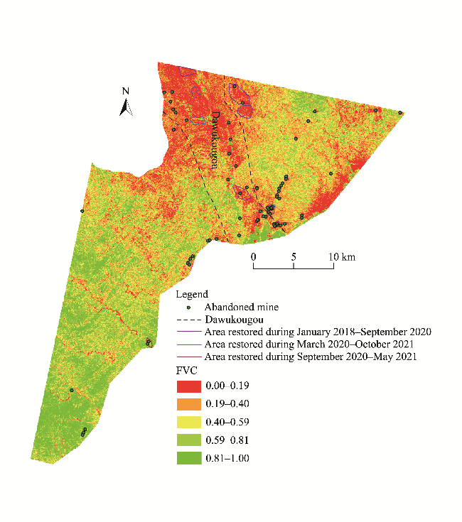
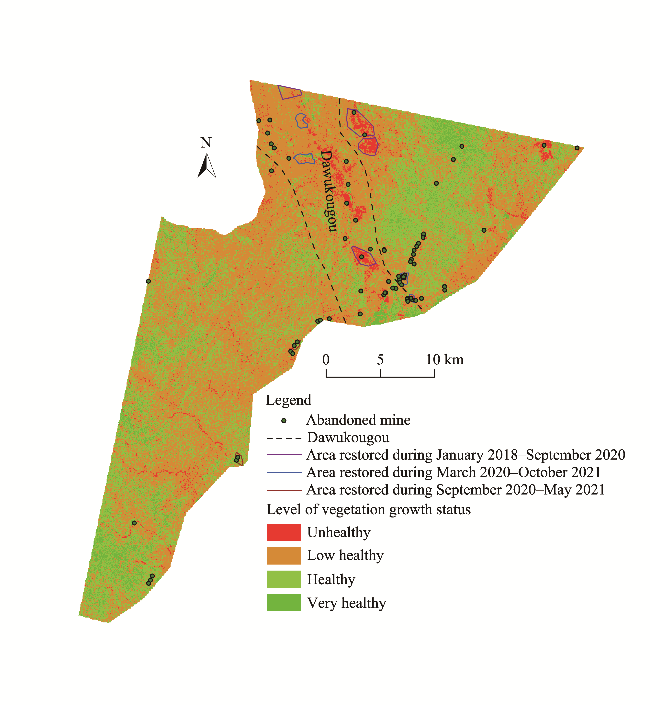
The vegetation growth status largely represents the ecosystem function and environmental quality. Hyperspectral remote sensing data can effectively eliminate the effects of surface spectral reflectance and atmospheric scattering and directly reflect the vegetation parameter information. In this study, the abandoned mining area in the Helan Mountains, China was taken as the study area. Based on hyperspectral remote sensing images of Zhuhai No. 1 hyperspectral satellite, we used the pixel dichotomy model, which was constructed using the normalized difference vegetation index (NDVI), to estimate the vegetation coverage of the study area, and evaluated the vegetation growth status by five vegetation indices (NDVI, ratio vegetation index (RVI), photochemical vegetation index (PVI), red-green ratio index (RGI), and anthocyanin reflectance index 1 (ARI1)). According to the results, the reclaimed vegetation growth status in the study area can be divided into four levels (unhealthy, low healthy, healthy, and very healthy). The overall vegetation growth status in the study area was generally at low healthy level, indicating that the vegetation growth status in the study area was not good due to short-time period restoration and harsh damaged environment such as high and steep rock slopes. Furthermore, the unhealthy areas were mainly located in Dawukougou where abandoned mines were concentrated, indicating that the original mining activities have had a large effect on vegetation ecology. After ecological restoration of abandoned mines, the vegetation coverage in the study area has increased to a certain extent, but the amplitude was not large. The situation of vegetation coverage in the northern part of the study area was worse than that in the southern part, due to abandoned mines mainly concentrating in the northern part of the Helan Mountains. The combination of hyperspectral remote sensing data and vegetation indices can comprehensively extract the characteristics of vegetation, accurately analyze the plant growth status, and provide technical support for vegetation health evaluation.

Cite this article

MAO Zhengjun , WANG Munan , CHU Jiwei , SUN Jiewen , LIANG Wei , YU Haiyong . Feature extraction and analysis of reclaimed vegetation in ecological restoration area of abandoned mines based on hyperspectral remote sensing images[J]. Journal of Arid Land, 2024 , 16(10) : 1409 -1425 . DOI: 10.1007/s40333-024-0109-9

1 Introduction

Restoration and reconstruction of ecosystem in mining areas generally go through five stages of "geomorphic remodeling, soil reconstruction, vegetation reconstruction, landscape reconstruction, and biodiversity reorganization and protection" (Bai et al., 2018). Vegetation is an important part of terrestrial ecosystems and a natural link connecting atmosphere, hydrosphere, and soil, playing an important role in soil and water conservation, carbon cycle, and ecological stability. Vegetation reconstruction is an important guarantee for the restoration and reconstruction of mining ecosystem (Parmesan and Yohe, 2003; Sun et al., 2015). Vegetation feature is generally evaluated by vegetation coverage or vegetation growth status. Vegetation coverage is usually defined as the percentage of the vertical projection area of vegetation (including leaves, stems, and branches) on the ground to the total area of the statistical area, which is an important parameter to characterize the surface vegetation coverage (Ma et al., 2013). The growth status of vegetation represents the functions of ecosystem and the quality of environment to a great extent, and it is also an important parameter for evaluating the quality of environment (Wang, 2019).
Researchers usually use the biomass detection method and traditional multispectral remote sensing method to evaluate the growth status of vegetation. The traditional biomass detection method takes time and manpower to collect a large number of plant samples and conduct a series of chemical experiments to obtain various physical and chemical parameter information about plants. This method causes different degrees of damage to the collected plant samples (Bi, 2017). Remote sensing technology has the advantages of multi-temporal, high efficiency, and all-weather characteristics, which enable it to realize dynamic and continuous monitoring in a large area (Brown and McCarty, 2017). The traditional multispectral remote sensing method obtains images with different bandwidths (usually 100-200 nm) in several discrete bands, which makes it easy to lose a large amount of useful spectral information for ground object recognition (Goetz et al., 1985). However, the landscape pattern of ecosystem is complex and the spatial distribution and structural composition are disordered, thus it is not sufficient to observe the ecosystem by using several discrete broadband bands of multispectral remote sensing data. Accurately inverting various complex attributes of terrestrial objects and biochemical parameters within ecosystems is a challenging task (Yue et al., 2008; Zhang et al., 2023b).
Hyperspectral remote sensing takes the high-resolution spectral characteristics of the interaction between the target object and the electromagnetic wave as the research object (Goetz et al., 1985). The differences between hyperspectral and traditional multispectral remote sensing are mainly narrow band and multi-channel. Compared with multispectral, the hyperspectral imaging can obtain continuous spectral information of ground objects with ultra-high spectral resolution at nanometer level and tens or hundreds of bands at the same time. Hyperspectral remote sensing breaks through the limitation of spectral resolution and provides strong support for more in-depth remote sensing vegetation information extraction, thus strengthening the detection and identification of subtle differences at plant species, function, and gene levels (Peng et al., 2014; Zhang et al., 2023b). In addition, hyperspectral data can effectively eliminate the influence of the surface spectral reflectance and atmospheric scattering to directly reflect the vegetation parameter information. By using hyperspectral remote sensing data to extract the spectral feature index, the vegetation status of earth surface can be qualitatively and quantitatively assessed (Campbell, 1987; Bannari et al., 1996).
The Helan Mountains are an important natural geographical boundary and an important ecological security barrier in Northwest China, maintaining the climate distribution and ecological pattern from Northwest China to the Huanghuai region and protecting the ecological security of Northwest China and North China. The Helan Mountains are rich in coal, silica, and other resources. Since the 1950s, they have been subjected to large-scale disorderly mining, leaving ravines and devastated mountains (Liu et al., 2021). In May 2017, the comprehensive improvement of the environment within the Helan Mountain Nature Reserve was implemented. In 2019, the comprehensive improvement of the key areas outside the Helan Mountain Nature Reserve was implemented. And in 2021, a five-year plan for ecological protection and restoration in the Helan Mountains was formulated (Ningxia Helan Mountain National Nature Reserve Management Bureau, 2022). In this study, the abandoned mining area in the Helan Mountains was taken as the study area. By combining hyperspectral remote sensing data with vegetation index, the vegetation coverage of the study area was estimated and the vegetation growth status was evaluated. The aims of the study are: (1) to extract the vegetation data using hyperspectral remote sensing data; (2) to analyze the distribution and the growth status of reclaimed vegetation in abandoned mine restoration area; (3) to discuss the effects and influence factors of ecological restoration in abandoned mines; and (4) to put forward the difficulties faced by ecological restoration of abandoned mines. The results of this study can provide technical support for the evaluation of the ecological restoration effect in mining areas based on hyperspectral remote sensing images.

2 Study area and data

2.1 Study area

The study area (38°48′54″-39°11′49′′N, 106°05′10′′-106°37′59′′E), a part of the Helan Mountains, is located in Shizuishan City, Ningxia Hui Autonomous Region, China, with an elevation of approximately 1155-2342 m and a total area of approximately 307.38 km2 (Fig. 1). The study area is located in the northeastern margin of the Qinghai-Xizang Plateau and the western margin of North China, and is bounded by the Alashan Block to the west and the Ordos Block to the east. It is affected by the Dengkou-Benjing fault, Hetun-Benjing fault, Zhengyiguan fault, Helanshan western foot fault, and Helanshan eastern foot fault (Wu et al., 2020). The study area has a typical continental climate, which is cool in autumn, cold and long in winter, and hot and short in summer. The annual average temperature is -0.7°C, of which the minimum temperature is in January (-13.9°C) and the maximum temperature is in July (12.1°C), and the temperature increases quickly in spring. The annual precipitation is 287.2-429.8 mm, and the precipitation is mainly concentrated in June-September, accounting for almost 62.00% of the annual precipitation. Strong wind and dust weather are frequent in the study area, and the frost-free days reach 60-70 d per year. The terrain in the study area is complex, the altitude as a whole presents the characteristics of high in the west and low in the east. The types of groundwater are mainly Quaternary loose rock pore water and bedrock fissure water, and the main source of groundwater is atmospheric precipitation (Li and Yang, 2021).
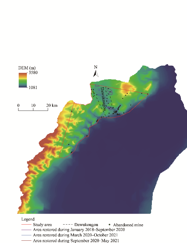
Fig. 1 Geographical location of the study area. DEM, digital elevation model.
The mineral resources in the study area include coal, silica, clay and limestone. Among these resources, the reserves of coal are large, the quality of coal is good, and the development history is long. Due to the exhaustion of coal resources after 2000, the mines in the study area were gradually closed until 2017. The disorderly mining has caused serious destruction to the mining area. The ecological restoration of abandoned mine in the Helan Mountains started in 2017. Until the day that the hyperspectral satellite remote sensing data were obtained, the restoration projects have been carried out at ten abandoned mines by three stages. Specifically, four areas that are located in the northern part of the Helan Mountains were restored from January 2018 to September 2020, four areas were restored from March 2020 to October 2020, and two areas that are located in the southern part were restored from September 2020 to May 2021 (Fig. 1). In this study, we also analyzed and discussed the ecological restoration effects of the ten areas.

2.2 Data sources and preprocessing

The experimental data utilized in this study were sourced from the Zhuhai No. 1 hyperspectral satellite remote sensing dataset, provided by Obit Company (Zhuhai City, China). The four hyperspectral satellites in the Zhuhai No. 1 satellite constellation are the only commercial hyperspectral satellites launched and networked by China (Zhang et al., 2024). The Zhuhai No. 1 hyperspectral satellite is equipped with multiple complementary metal oxide semiconductor sensors. The spatial resolution is 10 m and the imaging range is 150 km×2500 km; the spectral resolution is 2.5 nm, the number of bands is 32, and the spectral range is 400.0-1000.0 nm. The data used in this study were acquired on 22nd June, 2021.
In this study, radiometric calibration, atmospheric correction, and geometric correction preprocessing were performed on the hyperspectral satellite remote sensing data. The radiance was converted into dimensionless atmospheric apparent reflectance data via radiometric calibration. The real surface reflectance information about the ground objects was obtained via atmospheric correction calculations. The digital elevation model (DEM) data with the spatial resolution of 12.5 m were obtained from National Aeronautics and Space Administration (NASA) (Fan et al., 2023).

3 Methods

3.1 Vegetation coverage estimation

The vegetation coverage, represented by fractional vegetation cover (FVC), is the ratio of the vertical projection area of each pixel of vegetation on the ground to the total area of the pixel in the remote sensing image (Du et al., 2019; Lu et al., 2021). The estimated value of vegetation coverage can directly reflect the size of the vegetation area. It is a key indicator of ecosystem balance and has been widely used in environment monitoring of mining areas (Liu et al., 2019; Sun et al., 2021; Zhang et al., 2022; Zhang et al., 2023a). When the vegetation coverage is reduced to a certain proportion, it will lead to soil erosion, which in turn will cause damage to soil structure and lead to disasters such as debris flows and surface subsidence (Zhong et al., 2024).
In this study, hyperspectral remote sensing images were used as the data source, and the vegetation coverage in the study area was estimated using the pixel dichotomy model. The pixel dichotomy model is relatively simple to calculate and is not limited by area. It can reflect the growth and distribution of vegetation in one area more comprehensively. However, this method only uses the confidence interval to identify the upper and lower thresholds of normalized difference vegetation index (NDVI), which has certain limitations. Pixels in remote sensing images often contain multiple land cover types, and a simple pixel dichotomy model may not accurately distinguish between vegetation and non-vegetation, leading to an insufficient accuracy of estimation results. The pixel dichotomy model assumes that the spectral information reflected by the pixel is only composed of pure vegetation and pure bare soil (Jia et al., 2013; Yu et al., 2023).
$R=R\text{v}+R\text{s}$,
$R\text{v}=\text{FVC}\times R\text{veg}$,
$R\text{s}=\left( 1\text{FVC} \right)\times R\text{soil}$,
$\text{FVC}=\frac{RR\text{soil}}{R\text{veg}R\text{soil}}$,
where R is the reflectivity of the pixel (%); Rv is the vegetation reflectance (%); Rs is the bare soil reflectance (%); FVC is the fractional vegetation cover in the pixel, ranging from 0.00 to 1.00; Rveg is the reflectance of the pixel covered by pure vegetation (%); and Rsoil is the bare soil reflectance in the pixel (%).
The NDVI value in the pixel can be decomposed into the linear sum of the NDVI values of the vegetation and bare soil, so the FVC also can be calculated as follows:
$\text{FVC}=\frac{I\text{NDVI}I\text{NDV}{{\text{I}}_{s}}}{I\text{NDV}{{\text{I}}_{v}}I\text{NDV}{{\text{I}}_{s}}}$,
where $I\text{NDV}{{\text{I}}_{v}}$ and $I\text{NDV}{{\text{I}}_{s}}$ are the NDVI values of the pure vegetation and pure bare soil of the pixel, respectively; and INDVI is the value of NDVI of the pixel.
In the pixel dichotomy model, $I\text{NDV}{{\text{I}}_{v}}$ and $I\text{NDV}{{\text{I}}_{s}}$ are the key parameters that affect the accuracy of the model. In theory, the value of $I\text{NDV}{{\text{I}}_{v}}$ is close to 1, and the value of $I\text{NDV}{{\text{I}}_{s}}$ is close to 0. However, in reality, due to the influence of factors such as the land cover type, the spatial distribution of vegetation cover, and mixed pixels, the values of $I\text{NDV}{{\text{I}}_{v}}$ and $I\text{NDV}{{\text{I}}_{s}}$ change in time and space (Wang and Dai, 2018; Zhang and Lin, 2020).

3.2 Evaluation of vegetation growth status

3.2.1 Selection of vegetation index

This study established an evaluation index system for the growth status of reclaimed vegetation based on five principles: independence, representativeness, scientific rigor, systematic approach, and practicality. The primary indicators encompass three aspects: greenness, light utilization, and chlorophyll.
The vegetation indices for the greenness indicator included NDVI and ratio vegetation index (RVI) in this study (An et al., 2022).
$\text{NDVI}=\frac{{{\rho }_{\text{NIR}}}-{{\rho }_{\text{RED}}}}{{{\rho }_{\text{NIR}}}+{{\rho }_{\text{RED}}}}$,
$\text{NDVI}=\frac{{{\rho }_{\text{NIR}}}}{{{\rho }_{\text{RED}}}}$,
where ρNIR is the reflectance of near infrared band (%); and ρRED is the reflectance of red band (%).
The vegetation indices for the light utilization indicator included photochemical reflectance index (PRI) and red-green ratio index (RGI) in this study (Ma et al., 2013; Chen et al., 2022).
$\text{PRI}=\frac{{{\rho }_{531}}-{{\rho }_{570}}}{{{\rho }_{531}}+{{\rho }_{570}}}$,
$\text{RGI}=\frac{{{\rho }_{R}}}{{{\rho }_{G}}}$,
where ρ531 and ρ570 are the reflectance at the wavelength of 531 and 570 nm, respectively (%); ρR is the mean reflectance of all bands in the red range (%); and ρG is the mean reflectance of all bands in the green range (%).
The vegetation index for chlorophyll indicator was the anthocyanin reflectance index 1 (ARI1) in this study (Chen et al., 2022).
$\text{ARI1}=\frac{1}{{{\rho }_{550}}}-\frac{1}{{{\rho }_{700}}}$,
where ρ550 and ρ700 are the reflectance at the wavelength of 550 and 700 nm, respectively (%).

3.2.2 Determination of index weight

In monitoring and evaluation of the vegetation growth status, the determination of the weight of each vegetation index is very important. The triangular fuzzy number analytic hierarchy process (TFN-AHP) is an improvement of the fuzzy analytic hierarchy process. After establishing the hierarchical structure model, the TFN-AHP constructs the fuzzy judgment matrix using the triangular fuzzy number, calculates the fuzzy comprehensive degree value, and obtains the weight vector of each layer element. Compared with the analytic hierarchy process, the advantage of TFN-AHP is that when the triangular fuzzy number is used to construct the fuzzy consistency judgment matrix, the consistency judgment is made. By calculating the maximum eigenvalue of the judgment matrix and its corresponding eigenvector, the consistency of the judgment matrix can be tested. In addition, compared with the traditional analytic hierarchy process, the accuracy of the evaluation results of TFN-AHP has been significantly improved (Cai et al., 2021; Mao et al., 2022). In this study, the TFN-AHP was used to determine the weight of each index.
To determine the relative importance of each pair of factors at the same level, we used triangular fuzzy number in the TFN-AHP method. Through pairwise comparison, we used a scale of 1-9 to score each index and construct a fuzzy judgment matrix. The normalized weight value is obtained using Equation 11:
$wi=\frac{di}{\sum\nolimits_{i=1}^{n}{di}}$,
where wi is the normalized weight of indicator i; di is the score of indicator i; and n is the total number of indicators.

3.2.3 Evaluation model

The vegetation growth status evaluation model established in this study is shown in Equation 12 (Ma et al., 2013; Hong et al., 2016):
$\text{VGI}=\left( \sum\limits_{j=1}^{e}{{{v}_{a}}{{w}_{a}}} \right)\times W1+\left( \sum\limits_{k=1}^{m}{{{v}_{b}}{{w}_{b}}} \right)\times W2+\left( \sum\limits_{z=1}^{g}{{{v}_{c}}{{w}_{c}}} \right)\times W3$,
where VGI is the vegetation growth index; W1, W2, and W3 are the weights of the greenness, light utilization, and chlorophyll indicators, respectively; va, vb, and vc are the vegetation index values of the greenness, light utilization, and chlorophyll indicators, respectively; wa, wb, and wc are the corresponding weights of vegetation indices of greenness, light utilization, and chlorophyll indicators, respectively; j, k, and z are the number of vegetation indices of the greenness, light utilization, and chlorophyll indicators, respectively; and e, m, and g are the total number of vegetation indices of the greenness, light utilization, and chlorophyll indicators, respectively.

4 Results

4.1 Vegetation coverage

Based on the pixel binary model, we estimated the vegetation coverage in the study area. Using the natural breaks method, we classified the vegetation coverage of the study area into five levels: low coverage (0.00≤FVC<0.19), moderate-low coverage (0.19≤FVC<0.40), moderate coverage (0.40≤FVC<0.59), moderate-high coverage (0.59≤FVC<0.81), and high coverage (0.81≤FVC<1.00).
As shown in Figure 2, it can be seen that the vegetation coverage in Dawukougou, extending from the northwest to the southeast in the study area, was concentrated in the range of 0.00-0.19 (low coverage level). The FVC in the southwestern part of the study area was at high coverage level (0.81-1.00), there were almost no abandoned mines in this area, and the area had the highest vegetation coverage. The FVC in the eastern part of the study area was 0.19-0.81, having moderate-low coverage, moderate coverage, and moderate-high coverage levels, and there were few abandoned mines.
Fig. 2 Spatial distribution of vegetation coverage in the study area. FVC, fractional vegetation cover.
In the study area, the area of low coverage level was 48.81 km2, accounting for 15.88% of the whole study area, indicating that there were significant areas that vegetation growth has not yet effectively commenced in the Helan Mountains restoration area (Table 1). The area of moderate-low vegetation coverage level was 72.08 km2, accounting for 23.45%, implying that some areas have started to develop a certain amount of vegetation. The area of moderate vegetation coverage level was 77.74 km2, which was the highest proportion of 25.29%, indicating that these areas had a relatively good state of vegetation recovery, contributing positively to the restoration of ecological functions. The area of moderate-high vegetation coverage level was 65.44 km2, accounting for 21.29%, reflecting a certain level of vegetation health, which was conducive to better soil and water conservation functions. Finally, the area of high vegetation coverage level was 43.31 km2, making up 14.09% of the whole study area. Although this proportion was relatively small, it indicated that certain areas have successfully revived, possessing a good ecological environment.
Table 1 Area and proportion of vegetation coverage at different levels in the study area
Classification Area (km2) Proportion (%)
Low coverage level (0.00≤FVC<0.19) 48.81 15.88
Moderate-low coverage level (0.19≤FVC<0.40) 72.08 23.45
Moderate coverage level (0.40≤FVC<0.59) 77.74 25.29
Moderate-high coverage level (0.59≤FVC<0.81) 65.44 21.29
High coverage level (0.81≤FVC<1.00) 43.31 14.09

Note: FVC, fractional vegetation cover.

The vegetation coverage in the abandoned mine of ecological restoration period during January 2018-September 2020 was primarily at low coverage level (0.00-0.19). Though almost three years restoration, which is the longest restoration time for the Helan Mountain Nature Reserve, the vegetation and ecology environment in this area was still worse, due to the severely damaged soil structure, which lead to nutrient loss and further poor soil conditions that were unfavorable for vegetation growth. For areas that the ecological restoration period was during March 2020-October 2020, the FVC value varied, with some areas that were located in the northeastern part of the study area reaching 0.40-0.59, and some areas that were located in the northwestern part at the range of 0.00-0.19. These restoration areas have many steeps, rocky slopes, which are characterized by long slope faces, significant elevation differences, and steep gradients. Due to the hard texture of the rocky slopes, there is insufficient space for plant root growth and lack of necessary moisture, soil environment, and growth conditions for vegetation. For areas that ecological restoration period was during September 2020-May 2021, the vegetation coverage was mainly at medium-high coverage and high coverage levels, of which the vegetation coverage of the abandoned mine close to the northeastern part was mainly at 0.19-0.59, while the vegetation coverage of the abandoned mine in the southern part was mainly at 0.59-1.00. These ecological restoration areas were dominantly in the southern part of the study area where the climatic conditions were relatively favorable compared to other parts of the study area, with ample precipitation and suitable temperatures, which facilitated rapid vegetation recovery and promoted growth. In short, the overall vegetation coverage of the abandoned mine ecological restoration area has been improved to a certain extent, especially in the abandoned mine that ecological restoration was completed from March 2020 to October 2020.

4.2 Vegetation growth status

The weights of the vegetation growth evaluation indices based on the TFN-AHP are presented in Table 2. Among the three vegetation index categories, the weight of the chlorophyll indicator was 0.3738, which was the highest among the three vegetation indicators. The weights of greenness and chlorophyll indicators were similar. The light utilization indicator had the lowest effect on the vegetation growth, with a weight of 0.2764. Among the five vegetation indices, the ARI1 (0.2842) had the highest weight. The weights of the PRI (0.2156) and NDVI (0.2125) were close to that of the ARI1, and the RGI (0.1233) had the least influence on the vegetation growth.
Table 2 Weight of each vegetation index based on the triangular fuzzy number analytic hierarchy process (TFN-AHP)
Vegetation indicator Weight Vegetation index Weight
Greenness 0.3498 Normalized difference vegetation index (NDVI) 0.2125
Ratio vegetation index (RVI) 0.1643
Light utilization 0.2764 Photochemical vegetation index (PRI) 0.2156
Red-green ratio index (RGI) 0.1233
Chlorophyll 0.3738 Anthocyanin reflection index 1 (ARI1) 0.2842
Based on Equation 12, we used ArcGIS 10.6 (Eris, Redlands, California, USA) to superimpose and analyze each pixel in the study area to obtain a zone map of the vegetation growth status of the study area (Fig. 3). The vegetation growth index ranged from 0.14 to 0.48 and was divided into the following four levels using the natural breakpoint method: unhealthy (0.14-0.22), low healthy (0.22-0.25), healthy (0.25-0.27), and very healthy (0.27-0.48). The overall vegetation growth status in the study area was at low healthy and healthy levels, indicating that the baseline growth condition of vegetation in the area was suboptimal. The unhealthy growth status was primarily concentrated in Dawukougou, extending from the northwest to the southeast of the study area. The vegetation growth status of the central part of the study area was mostly at low healthy level.
Fig. 3 Spatial distribution of vegetation growth status in the study area
For areas that ecological restoration period was during January 2018-September 2020, the vegetation growth status was at unhealthy level due to significant impacts from mining activities, which were detrimental to vegetation growth. For areas that the ecological restoration period was during March 2020-October 2020, the vegetation growth status was primarily classified as low healthy and healthy levels. For these restoration areas, the geological conditions were poor, failing to provide sufficient growth space for plant roots and lacking necessary water, soil conditions, and growth conditions for plants. For areas that the ecological restoration period was during September 2020-May 2021, the vegetation growth status remained mostly at low healthy level, partly because the restoration time was relatively short. Using ArcGIS 10.6, the vegetation growth index of typical reclaimed vegetation in the study area has been extracted. The average values of vegetation growth index for the four abandoned mines of restoration period during January 2018-September 2020 were 0.21, 0.21, 0.22, and 0.24, respectively. The average values of vegetation growth index for the four abandoned mines of restoration period during March 2020-October 2020 were 0.23, 0.23, 0.23, and 0.24, respectively; and the average values of vegetation growth index for the two abandoned mines of restoration period during September 2020-May 2021 were 0.26 and 0.23, respectively.

4.3 Comparative analysis of vegetation coverage and vegetation growth status

Comparing Figures 2 and 3, it can be seen that the vegetation coverage in the southwestern part of the study area was concentrated in the range of 0.59-1.00, and the growth status of reclaimed vegetation of this area was at low healthy, healthy, and very healthy levels. In the northwestern part of the study area, the coverage of reclaimed plants was concentrated in the range of 0.00-0.19, and the vegetation growth status in this area was at unhealthy and low healthy levels. There were tiny differences in the expression of vegetation features between the vegetation coverage and vegetation growth status. In the study area, the areas with higher level of vegetation growth status may not be with better vegetation coverage; and the areas with lower level of vegetation growth status may not be with worse vegetation coverage.
The difference between the evaluation results of vegetation coverage and vegetation growth status is mainly due to the different principles adopted by them. Vegetation coverage is the ratio between the vertical projected area of vegetation on the ground and the total area of each pixel in remote sensing images. The estimated value of vegetation coverage can directly reflect the size of vegetation area. Generally, pixel dichotomy model determines vegetation coverage by dividing the surface features in mixed pixels into vegetation and non-vegetation. However, limited by the spatial resolution of remote sensing images, a single pixel often contains multiple types of land cover and lacks pure pixel sample points, which poses challenges to the accuracy of vegetation coverage inversion, especially in complex landscape scenes. It will lose a certain precision, so the vegetation coverage is relatively extreme to express the characteristics of vegetation. Hyperspectral remote sensing imagery has advantages in spatial resolution and spectral detail, providing richer vegetation information and improving the identification of different plant species. However, hyperspectral data are susceptible to environmental factors, such as atmospheric interference, soil background variability, and the spectral mixing effect of vegetation, which leads to uncertainties in data interpretation. As a result, when directly used for calculating vegetation coverage, it still fails to accurately reflect the actual conditions. The evaluation of vegetation growth status is a comprehensive evaluation using multiple vegetation indices such as greenness, light utilization, and chlorophyll content indicators. The comprehensive evaluation can consider various factors, comprehensively analyze the evaluation problem, reflect the overall situation of the evaluated object.

4.4 Effects of ecological restoration on abandoned mines

Through the field investigation, the abandoned mines in the study area are mainly coal, silica, quartz sand, iron ore, and clay ore. Since the 1950s, the Helan Mountains have been subject to large-scale and disorderly mining, leaving behind ravines and devastated mountains. In 2017, the government of Ningxia Hui Autonomous Region started to implement ecological environment improvement projects in the Helan Mountains to restore the damaged ecological environment by carrying out engineering measures such as slope cutting and platform building, pit backfilling, dangerous rock removal, land leveling, and soil covering and greening for most abandoned mines. Mining would cause damage to topographic and geomorphic landscape, and then cause damage and occupation of land resources, which can also lead to geological disasters such as landslide and collapse. Open-pit mining must directly peel off a large amount of ground and soil and a large number of vegetation growing on it, which is devastating to the land and natural landscape. In addition, it also forms a large area of exposed high and steep rock face and mining pit, which makes the mountain devastated, destroys the integrity of the original natural landscape, and causes serious visual pollution. Moreover, the accumulation of solid waste generated in the mining process and the related office, production, and living sites further aggravates the destruction of forest trees and land resources.
The landform landscape of abandoned mine ecological restoration area after ecological restoration has undergone great changes, forming three landform types: platform-slope system, mine pit, and flat land, as shown in Figure 4. The platform-slope system was filled, levelled, and compacted in layers (Fig. 4a). The fillings are mainly hard rock fragments, sand particles, or gravel soil left over from abandoned mines. In order to further vegetation ecological restoration, the surface of platform-slope system is covered with a certain thickness of soil layer. The mine is a pit left over from abandoned mining, which has not been filled or treated during ecological restoration. As shown in Figure 4b, most of the pits are filled with water, and the side slopes are loose and easy to be unstable. Flat land is a relatively flat site left over from abandoned mining, as shown in Figure 4c. In the process of ecological restoration, the flat land was leveled and covered with soil, and the vegetation growth was the best.
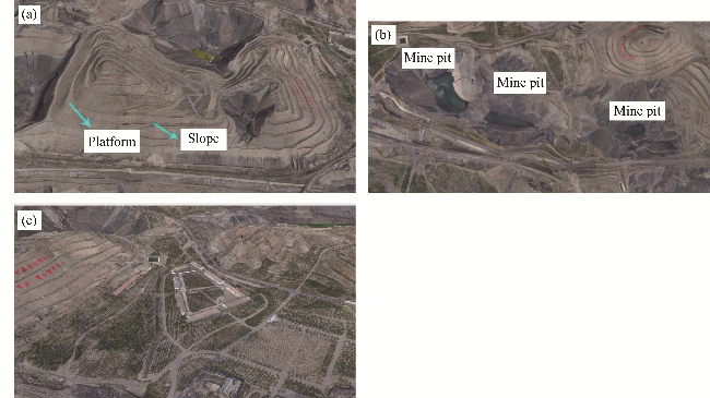
Fig. 4 Landform type of abandoned mine after ecological restoration in the study area. (a), platform-slope system; (b), mine pit; (c), flat land.

5 Discussion

5.1 Influencing factors of ecological restoration on abandoned mines

5.1.1 Existed mining activity

It can be seen from Figure 2 that the abandoned mines in the study area were concentrated and the vegetation coverage of the mine concentrated area was low. The area with almost no abandoned mines had the highest vegetation coverage. Areas with less abandoned mines had higher vegetation coverage. As can be seen from Figure 3, the unhealthy level vegetation was mainly located in the concentrated mining area of Dawukougou.
Vegetation is an important part of the ecosystem and is vital for the long-term stable growth of the ecosystem, playing an important role in the evolution of the landform and a key role in soil and water conservation, carbon absorption, and biodiversity maintenance (Kuang et al., 2024; Tang and Zhang, 2024). The vegetation coverage and vegetation growth status indicated that the original mining activities had a great impact on the vegetation ecology in the study area. In the process of mineral resource development, the mining activities, which exchange and transfer material and energy with geological environment, are the main factors affecting the change of geological environment of mines. The impact of mining activities on geological environment has a long-term and complex impact, and some of its consequences are very serious. The mode of influence can be physical or chemical, direct or indirect, long-term or short-term, and sharp or slow (Xu, 2006). The environmental geological problems caused by mining activities are multifaceted, such as the construction of industrial sites in mines, the excavation of ore in tunnels, the stripping of surface soil in open-pit mines, and the discharge of waste soil (Chen, 2018; Zhang and Xi, 2020). The exploitation of mineral resources first affects the land, whether it is the direct excavation loss of open-pit mining or the surface subsidence of well mining, the damage to the soil over hundreds or even tens of thousands of years (Hu, 2022).

5.1.2 Slope erosion

Erosion is the process by which soil is destroyed, eroded, transported, and deposited under external forces such as water power, wind power, freeze-thaw, or gravity (Singh and Hartsch, 2019). Mild erosion causes the loss of fertile topsoil layer and humus layer, which are formed by plant growth, then leading to decreasing in soil nutrient (Zhang et al., 2018). Strong erosion may lead to thinner soil layer, limited space for root growth, reduced water storage capacity and deprive the entire soil layer where plants can take root and obtain water and nutrients, leaving only hard rock (Zhou et al., 2008; Zhang, 2022). The slope erosion in the study area was mainly caused by hydraulic erosion, local gravity erosion, possibly wind erosion, and freeze-thaw erosion.
In recent years, heavy rainfall processes exceeding the historical extreme value often occurred in the study area, leading to frequent hydraulic erosion, which can be divided into three categories: splash erosion, surface erosion, and trench erosion (Li and Fang, 2016). When the rainfall intensity exceeds the infiltration of soil or the soil is fully saturated, the surface water generates a thin layer of water flow on the slope (the initial stage of surface runoff), the fine particles and soluble substances on the surface of the slope are washed away, and the hydraulic erosion changes from splash erosion to surface erosion, which mainly occur in the middle and lower part of the side slope. The soil covering the side slope is washed away and the gravel soil filled inside the slope is exposed. With the rainfall and the increase of water level in the fracture, the water flow is concentrated in the low-lying area with the change of slope relief, and the surface erosion further develops into trench erosion. With the continuous erosion of slope runoff, small particles are further lost in the small gully of bare gravel soil. With the alternating cycle of dry and wet, the hydraulic erosion capacity under the action of rainfall increases, and the number and degree of gully erosion on slope surface increase continuously (Ketema and Dwarakish, 2021). In addition, the gully erosion on the side slope bifurcates and joins until it extends to the bottom of slope and runs through and connects with the water erosion, which further aggravates the development degree of gully erosion on the side slope.
The study area is located in arid areas with little precipitation, strong evaporation, large diurnal temperature range, and high wind power. Due to the short ecological restoration time and low vegetation coverage rate of the slope, wind erosion is relatively strong, frequent, and continuous. Due to the low precipitation, dry climate, and low vegetation coverage in the study area, the wind causes diffuse sand and dust in the study area, and the cyclic wind erosion causes a certain degree of landslide. Due to the low temperature in winter and early spring, there may also be freeze-thaw erosion in the study area. The water in the soil or rock gap repeatedly freezes and thaws, resulting in constant expansion, contraction, fragmentation, and movement of soil and rock (Zhang et al., 2021).
The types of erosion such as landslide and collapse that deform, displace, and destroy the rock and soil mass of slope under the action of gravity are called gravity erosion (Rui et al., 2018). Landslides may be induced by tremors caused by earthquakes and artificial explosions. For example, earthquake and strong vibration of crust can reduce the strength of various structural planes in the slope rock mass, and even change the stability of the entire slope. It is greatly affected by rainfall and the duration of rainfall, and the infiltration of rainfall will cause the soil gravity to increase. The surface water such as rivers will continuously wash the slope foot or soak the slope foot, weaken the slope body support or soften the rock and soil body, and reduce the strength of the slope body, thus causing slide.

5.1.3 Precipitation

The study area is dry and rainless throughout the year. Precipitation has a more significant effect on vegetation growth in mountainous and desert areas (Kang et al., 2024). For arid and semi-arid areas, rainfall is the dominant factor limiting vegetation growth, and the lack of rainfall will further affect regional ecological environment quality. If rainfall is insufficient, water evaporation will be greater than precipitation, resulting in a decrease in the overall water volume. It is extremely unfavorable to the growth of plants (Yue et al., 2024). The increase of total precipitation, especially in the critical period of vegetation development, the decrease of high-intensity rainfall and the increase of small and medium rainfall in the basin all provide favorable conditions for further vegetation recovery (He et al., 2024). Extreme rainfall will flood the roots of the slope vegetation, reduce the oxygen in the soil, and destroy the growth of vegetation (Hao et al., 2024).

5.1.4 Long-term restoration

As above mentioned, a comprehensive implementation of the ecological environment improvement within the Helan Mountains was started in 2017 (Ningxia Helan Mountain National Nature Reserve Administration, 2022). Geomorphic remolding is the basis for the restoration and reconstruction of the ecosystem in the mining area. Based on the original topographical features of the abandoned mining area, and relying on mining design, extraction processes, and land degradation methods, the project aimed to reshape a new landform that harmonizes with the surrounding landscape through orderly waste disposal and land reshaping measures. This approach seeks to maximize the prevention and control of geological disasters, mitigate soil erosion, and eliminate or alleviate the detrimental limiting factors that affect vegetation restoration and the enhancement of land productivity, thus improving land utilization efficiency. Soil reconstruction is the core of ecosystem restoration and reconstruction in mining areas. Engineering measures and physical, chemical, and biological improvement measures that can restore and improve soil productivity in a relatively short period of time should be applied in abandoned mines in the study area to reconstruct a suitable soil profile and soil fertility conditions. However, soil reconstruction is not a one-time behavior but a long-term process (Hu et al., 2005). Vegetation reconstruction is the guarantee for the restoration and reconstruction of the ecosystem in the mining area. Based on the climate, altitude, slope, slope direction, surface material composition, and effective soil layer thickness of the abandoned mine in the study area, the government has carried out species selection (pioneer plants and suitable plants, such as Lonicera japonica, Acanthopanax senticosus, and Picea asperata), vegetation allocation, planting and managing of different damaged land types to ensure the sustainable stability of the reconstructed plant community. Landscape reconstruction is the structural optimization and functional improvement of the restoration and reconstruction of mining area ecosystem. The reorganization and protection of biodiversity is the highest stage in the mining area ecosystem restoration and reconstruction to maintain the stability of the ecosystem, and there is still a long way to go.

5.2 Difficulties in ecological restoration

5.2.1 Monitoring data

Due to the lack of data sources, this study only relied on the single temporal phase data, which are difficult to fully reflect the dynamic process of vegetation restoration. In the practical application of mine remote sensing monitoring, due to a large number of field investigations, the monitoring data are sometimes collected only when the working period is about to expire. It is difficult to obtain large-scale, full coverage, and high spatial resolution crop remote sensing data (Liu et al., 2018). The single temporal phase data cannot represent the complete growth state of vegetation. Based on the long-term comprehensive analysis of vegetation index, time series analysis ensures the combination of multiple wavelengths and can describe the characteristics of vegetation more accurately than single-phase data (Yan, 2023).

5.2.2 Ecological restoration of high and steep rock slope

There are also a large number of high and steep rock slopes in the study area, as shown in Figure 5. The high steep rock slope has long slope surface, obvious drop, and steep slope height. Due to the relatively hard texture of the rock slope, it can neither provide sufficient growth space for vegetation roots nor lack of water, soil environment, and growth conditions that are necessary for plant growth. Therefore, the ecological restoration of high and steep rock slope is the difficulty and key point of mine ecological restoration (He, 2023). In the repair of high and steep slopes, due to steep slope, long-term erosion and washing by rainwater can easily lead to the loss of water and nutrients, resulting in worse plant growth conditions, and further affecting the repair effect (Jin, 2023). The structural form and functional characteristics of high and steep rock slope ecological restoration technology have been sorted out, and the slope ecological restoration technologies suitable for slope stability treatment, slope protection treatment, and slope vegetation restoration in open pit mining area have been explored. Slope stability treatment technology aims to improve the overall stability of slope. The technology of slope protection is designed to reduce surface erosion. Slope vegetation restoration technology aims at improving the survival rate of plants and facilitating the later maintenance and management (Mao et al., 2021).
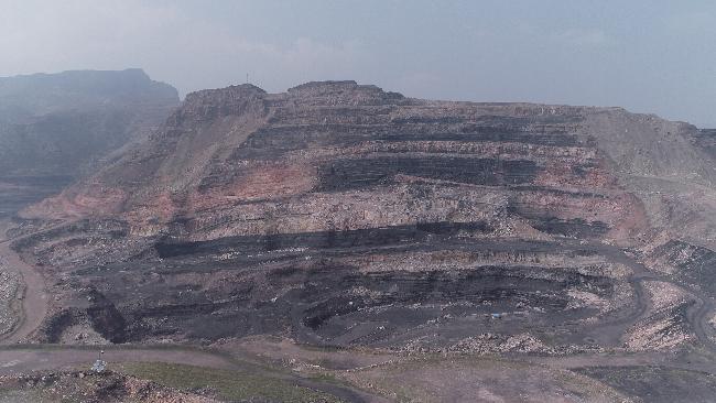
Fig. 5 Typical high and steep rock slope

6 Conclusions

In this study, based on hyperspectral remote sensing images, we used the pixel dichotomy model to estimate the vegetation coverage and the TFN-AHP to assessment the vegetation growth status in the abandoned mines in the Helan Mountains by determining the weights of NDVI, RVI, PRI, RGI, and ARI1. The results showed that the vegetation coverage was lower in the northern part of the study area where abandoned mines were more concentrated compared with the southern part where abandoned mines were less distributed. The areas of unhealthy vegetation growth level were mainly located in the Dawukougou where abandoned mines are concentrated. The vegetation growth status after ecological restoration of abandoned mines in the study area was mainly at low healthy and healthy levels, the areas of unhealthy level were mainly concentrated in Dawukougou. Combining the results of vegetation coverage and vegetation growth status, it can be seen that after four years implementation of restoration projects, the vegetation coverage of abandoned mines has improved to a certain extent, but the improvement effects were not significant. Diversified assessment methods such as the combination of hyperspectral remote sensing images and vegetation indices can provide immediate and relatively accurate feedback on ecological conditions, thus providing scientific basis for future ecological restoration decisions, and contributing to the optimization of restoration plans and resource allocation.

Conflict of interest

The authors declare that they have no known competing financial interests or personal relationships that could have appeared to influence the work reported in this paper.

Acknowledgements

This research was supported by the Ningxia Hui Autonomous Region Key Research and Development Plan (2022BEG03052).

Author contributions

Conceptualization: MAO Zhengjun; Data analysis: WANG Munan; Methodology: MAO Zhengjun,; Investigation: MAO Zhengjun, WANG Munan, YU Haiyong; Situation analysis: MAO Zhengjun, WANG Munan,; Writing - original manuscript preparation: WANG Munan, YU Haiyong; Written and editing: MAO Zhengjun, WANG Munan, CHU Jiwei; Financing acquisition: MAO Zhengjun, SUN Jiewen; Resources: MAO Zhengjun, SUN Jiewen, LIANG Wei; Supervisor: MAO Zhengjun, SUN Jiewen; Project Management: MAO Zhengjun, SUN Jiewen; Visualization: MAO Zhengjun. All authors approved the manuscript.
[1]
An D S, Yu D D, Liu Y, et al. 2022. A comparison of the LAI retrieval for subalpine meadows in Wuyishan by hyperspectral and simulated multispectral vegetation index. Ecological Science, 41(5): 187-196. (in Chinese)

[2]
Bai Z K, Zhou W, Wang J M, et al. 2018. Rethink on ecosystem restoration and rehabilitation of mining areas. China Land Science, 32(11): 1-9.

[3]
Bannari A, Morin D, Bonn F, et al. 1996. A review of vegetation indices. Remote Sensing Reviews, 13(1-2): 95-120.

[4]
Bi Y L. 2017. Research advance of application of arbuscular mycorrhizal fungi to ecological remediation in subsided land of coal mining areas. Mycosystema, 36(7): 800-806. (in Chinese)

[5]
Brown M E, McCarty J L. 2017. Is remote sensing useful for finding and monitoring urban farms? Applied Geography, 80: 23-33.

[6]
Campbell J B, Wynne R H. 1987. Introduction to Remote Sensing. New York: The Guilford Press, 551.

[7]
Cai S Y, Fan J M, Yang W, et al. 2021. Flooding risk assessment and analysis based on GIS and the TFN-AHP method: a case study of Chongqing, China. Atmosphere, 12(5): 623, doi: 10.3390/atmos12050623.

[8]
Chen C, Li S M, Wang Y Y, et al. 2022. Study on vegetation growth environment and spatial-temporal evolution in Wenshan Prefecture under high-resolution satellite monitoring. Journal of Yunnan University (Natural Sciences Edition), 44(6): 1183-1193. (in Chinese)

[9]
Du J Q, Quan Z J, Fang S F, et al. 2019. Spatiotemporal changes in vegetation coverage and its causes in China since the Chinese economic reform. Environmental Science and Pollution Research, 27: 1144-1159.

[10]
Fan Z Q, Wang Z G, Huang P P, et al. 2023. Inversion analysis of lake chlorophyll-a concentration based on hyperspectral images. Ecological Science, 42(1): 121-128. (in Chinese)

[11]
Feng J Z, Pan Y Q, Xiong Y S, et al. 2024. Rice key growth stage identification based on mRMR-XGBoost. Transactions of the Chinese Society of Agricultural Engineering, 40(15): 111-118. (in Chinese)

[12]
Goetz A F H, Vane G, Solomon J E, et al. 1985. Imaging spectrometry for earth remote sensing. Science, 228(4704): 1147-1153.

[13]
Hao G C, Dong Z L, Guo H W. 2024. Some thoughts on ecological restoration of highway exposed slope under the background of "double carbon". Transportation Energy Saving and Environmental Protection, 20(4): 123-127. (in Chinese)

[14]
He L. 2023. Ecological restoration practice of high and steep rock slope in open-pit mine. China Metal Bulletin, 17: 116-118. (in Chinese)

[15]
He Y, Chen Y C, Talat A E, et al. 2024. Spatio-temporal pattern and trend prediction of soil erosion in Kuye River Basin. Journal of Soil and Water Conservation, doi: 10.13870/j.cnki.stbcxb.2024.05.028. (in Chinese)

[16]
Hong J, Shu Q T, Wu J J, et al. 2016. The health classification of Pinus densata typical forest ecosystem in alpine region of northwestern Yunnan based on hyperion data. Journal of Southwest Forestry University (Natural Sciences), 36(6): 79-86. (in Chinese)

[17]
Hu X W, Cao S, Zhao X F. 2012. Comparison of green space information extraction based on vegetation index. Journal of Nanjing University of Information Science & Technology, 4(5): 420-425. (in Chinese)

[18]
Hu Z Q, Wei Z Y, Qin P. 2005. The concept and method of soil reconstruction for mine reclamation. Soils, 37(1): 8-12. (in Chinese)

[19]
Hu Z Q. 2022. Theory and method of soil reconstruction of reclaimed mined land. Journal of China Coal Society, 47(7): 2499-2515. (in Chinese)

[20]
Jia K, Yao Y J, Wei X Q, et al. 2013. A review on fractional vegetation cover estimation using remote sensing. Advances in Earth Science, 28(7): 774-782. (in Chinese)

[21]
Jin X Y. 2023. Study on the preparation and application effect of water-retaining material suitable for spray seeding substrate. MSc Thesis. Changchun: Jilin Agricultural University. (in Chinese)

[22]
Kang L F, Zhao R F, Lu H T, et al. 2024. Quantitative identification of the impact of climate change and human activities on the ecological quality of vegetation in the Shiyang River Basin over the past 20 years. Environmental Science, doi: 10.13227/j.hjkx.202404129. (in Chinese)

[23]
Ketema A, Dwarakish G S. 2021. Water erosion assessment methods: a review. ISH Journal of Hydraulic Engineering, 27(4): 434-441.

[24]
Kuang C P, Cong X, Han X J, et al. 2024. Review on hydrodynamic and sediment transport numerical models considering effects of coastal vegetation. Journal of Tongji University (Natural Science), 52(9): 1418-1427. (in Chinese)

[25]
Li S J, Yang X H. 2021. Analysis of hydrogeological conditions in Dawukou area of Shizuishan City, Ningxia. China Metal Bulletin, 9: 216-217. (in Chinese)

[26]
Li X S, Li Z Y, Gao Z H, et al. 2010. Estimation of sparse vegetation cover in arid regions based on vegetation indices derived from hyperion data. Journal of Beijing Forestry University, 32(3): 95-100. (in Chinese)

[27]
Li Z Y, Fang H Y. 2016. Impacts of climate change on water erosion: A review. Earth-Science Reviews, 163: 94-117.

[28]
Liu B R, Li G Q, Jiang X S. 2021. Countermeasures and evaluation of ecological restoration of mines in Helan Mountains Nature Reserve. Journal of Ningxia Agriculture and Forestry Science and Technology, 62(4): 40-43, 50. (in Chinese)

[29]
Liu D Y, Jia K, Wei X Q, et al. 2019. Spatiotemporal comparison and validation of three global-scale fractional vegetation cover products. Remote Sensing, 11(21): 2524, doi: 10.3390/rs11212524.

[30]
Liu Z, Liu D Y, Zhu D H, et al. 2018. Research progress and prospect of fine recognition and automatic mapping of crops by remote sensing. Transactions of Agricultural Machinery, 49(12): 1-12. (in Chinese)

[31]
Ma K. 2013. Research on the forest health evaluation of Qinling Huoditang based on the hyperspectral data. MSc Thesis. Xianyang: Northwest A & F University.

[32]
Ma K, Zhao P X, Ji F F, et al. 2013. Study on forest health assessment method based on vegetation index in Qinling Mountains. Journal of Northwest Forestry University, 28(6): 145-150. (in Chinese)

[33]
Mao Z J, Li C, Chen J P, et al. 2021. Present situation, environmental geological problems and countermeasures and suggestions of limestone open-pit mining area in Weibei. Coal Technology, 40(8): 91-94. (in Chinese)

[34]
Mao Z J, Shi S J, Li H, et al. 2022. Landslide susceptibility assessment using triangular fuzzy number-analytic hierarchy processing (TFN-AHP), contributing weight (CW) and random forest weighted frequency ratio (RF weighted FR) at the Pengyang County, Northwest China. Environmental Earth Sciences, 81: 86, doi: 10.1007/s12665-022-10193-3.

[35]
Ningxia Helan Mountain National Nature Reserve Management Bureau. 2022. Strengthen the Concept of Green Development to Build Harmony between Man and Nature—Ningxia Helan Mountain Ecological Protection and Restoration Has Achieved Remarkable Results—Harmonious Helan Mountain. [2024-03-01]. http://www.hlsbhq.com/index.php/shows/499/4817.html. (in Chinese)

[36]
Parmesan C, Yohe G. 2003. A globally coherent fingerprint of climate change impacts across natural systems. Nature, 421(6918): 37-42.

[37]
Peng Y, Mi K, Qin Y, et al. 2014. Spectral reflectance characteristics of dominant plant species at different eco-restoring stages in the semi-arid grassland. Spectroscopy and Spectral Analysis, 34(11): 3090-3094. (in Chinese)

[38]
Qiu D. 1991. Systematic Analysis of Multi-index Comprehensive Evaluation Method. Beijing: China Statistics Press, 123-124. (in Chinese)

[39]
Rui D H, Ji M C, Nakamur D, et al. 2018. Experimental study on gravitational erosion process of vegetation slope under freeze-thaw. Cold Regions Science and Technology, 151: 168-178.

[40]
Sun W Y, Song X Y, Mu X M, et al. 2015. Spatiotemporal vegetation cover variations associated with climate change and ecological restoration in the Loess Plateau. Agricultural and Forest Meteorology, 209-210: 87-99.

[41]
Sun X F, Yuan L G, Zhou Y Z, et al. 2021. Spatiotemporal change of vegetation coverage recovery and its driving factors in the Wenchuan earthquake-hit areas. Journal of Mountain Science, 18(11): 2854-2869.

[42]
Singh M, Hartsch K. 2019. Basics of soil erosion. In: Yousuf A, Singh M. Watershed Hydrology, Management and Modeling. CRC Press, 9-121.

[43]
Tang H, Zhang L T. 2024. Analysis of urban vegetation changes and drivers in plateau and river valleys. Environmental Science, doi: 10.13227/j.hjkx.202401244. (in Chinese)

[44]
Wang C. 2019. The responds of vegetation to the groundwater depth in the grassland open-pit coal mine area. MSc Thesis. Hohhot: Inner Mongolia University.

[45]
Wang M L, Dai X A. 2018. Study on the relationship between vegetation coverage and temperature based on MODIS hyperspectral data. Science of Surveying and Mapping, 43(4): 138-143. (in Chinese)

[46]
Wu G J, Tan H P, Sun K, et al. 2020. Characteristics and tectonic significance of gravity anomalies in the Helanshan-Yinchuan Graben and adjacent areas. Chinese Journal of Geophysics, 63(3): 1002-1013. (in Chinese)

[47]
Xu Y N. 2006. Investigation and Evaluation of Mine Environmental Geological Problems in Northwest China. Beijing: Geological Publishing House, 27-28. (in Chinese)

[48]
Yan J. 2023. Urban forest based on multi-source and multi-temporal remote sensing. MSc Thesis. Nanjing: Nanjing Forestry University. (in Chinese)

[49]
Yu T, Pang Y, Meng S L, et al. 2023. Remote sensing estimation and change analysis of fractional vegetation coverage in natural forest resource protection project area. Journal of Beijing Forestry University, 45(5): doi: 10.12171/j.1000-1522.20220324. (in Chinese)

[50]
Yue Y F, Zhao W Z, Liu R T, et al. 2024. Study on spatio-temporal changes and driving mechanisms of ecological environment quality in desert steppe belt of Ningxia. Acta Ecologica Sinica, 44(20): 1-14. (in Chinese)

[51]
Yue Y M, Wang K L, Zhang B, et al. 2008. Advances in the application of hyperspectral remote sensing in ecosystem re-search. Remote Sensing Technology and Application, 23(4): 471-478. (in Chinese)

[52]
Zhang C Y, Li J, Lei S G, et al. 2022. Progress and prospect of the quantitative remote sensing for monitoring the eco-environment in mining area. Metal Mine, 549(3): 1-27. (in Chinese)

[53]
Zhang F R. 2022. Introduction to Rocks, Soils and Lands. Beijing: China Agricultural University Press, 97-98. (in Chinese)

[54]
Zhang G C, Lin Z L. 2020. Research on vegetation coverage extraction based on hyperion hyperspectral remote sensing image. Journal of Fujian Normal University (Natural Science Edition), 36(1): 79-86, 95. (in Chinese)

[55]
Zhang J D, Xi F R. 2020. Study on ecological restoration of abandoned mines in China. Acta Ecologica Sinica, 40(21): 7921-7930. (in Chinese)

[56]
Zhang L, Ren F P, Li H, et al. 2021. The influence mechanism of freeze-thaw on soil erosion: a review. Water, 13(8): 1010, doi: 10.3390/w13081010.

[57]
Zhang P Q, Sun Y F, Chang Q Q, et al. 2024. Solid waste identification of Zhuhai-1 hyperspectral satellite remote sensing data based on optical flow estimation: a case study of Jiyuan demonstration area in Henan Province. Bulletin of Surveying and Mapping, 1: 44-50. (in Chinese)

[58]
Zhang X Q, Hu M C, Guo X Y, et al. 2018. Effects of topographic factors on runoff and soil loss in Southwest China. Catena, 160: 394-402.

[59]
Zhang Y B, Du J M, Bi Y G, et al. 2023a. Research on desert grassland coverage extraction method based on UAV hyperspectral remote sensing. Journal of Optoelectronics·Laser, 34(8): 842-850. (in Chinese)

[60]
Zhang Y W, Guo Y P, Tang R, et al. 2023b. Progress and trends of application of hyperspectral remote sensing in plant diversity research. National Remote Sensing Bulletin, 27(11): 2467-2483. (in Chinese)

[61]
Zhong A Y, Bao C, Hu C M. 2024. Spatiotemporal dynamic change monitoring of NDVI in mining areas of Dexing City from the perspective of ecological restoration. Environmental Engineering, 42(5): 122-130. (in Chinese)

[62]
Zhou P, Luukkanen O, Tokola T, et al. 2008. Effect of vegetation cover on soil erosion in a mountainous watershed. Catena, 75(3): 319-325.

Outlines

/