



基于疏勒河数字孪生流域平台的洪水预测模型及应用
|
安建民(1974-),男,正高级工程师,主要从事水资源和水利工程管理工作. E-mail: fl25685@163.com |
收稿日期: 2025-04-08
修回日期: 2025-08-11
网络出版日期: 2026-03-12
基金资助
甘肃省水利科学实验研究与技术推广项目(25GSLK077)
国家自然科学基金重点项目(42330512)
Development and application of a flood forecasting model based on the Shule River digital-twin basin platform
Received date: 2025-04-08
Revised date: 2025-08-11
Online published: 2026-03-12
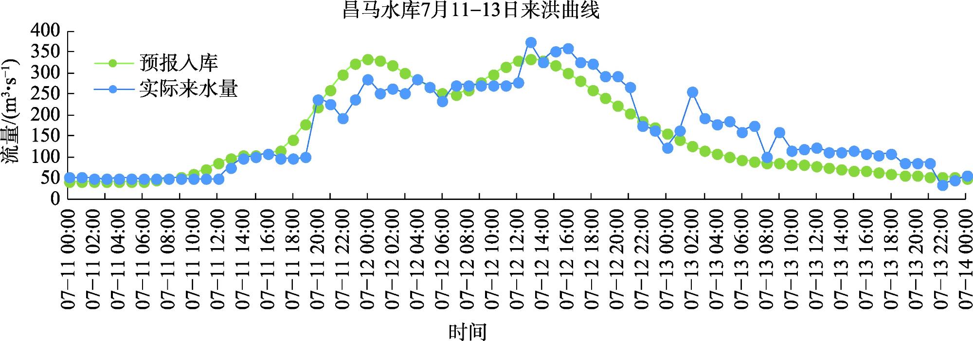
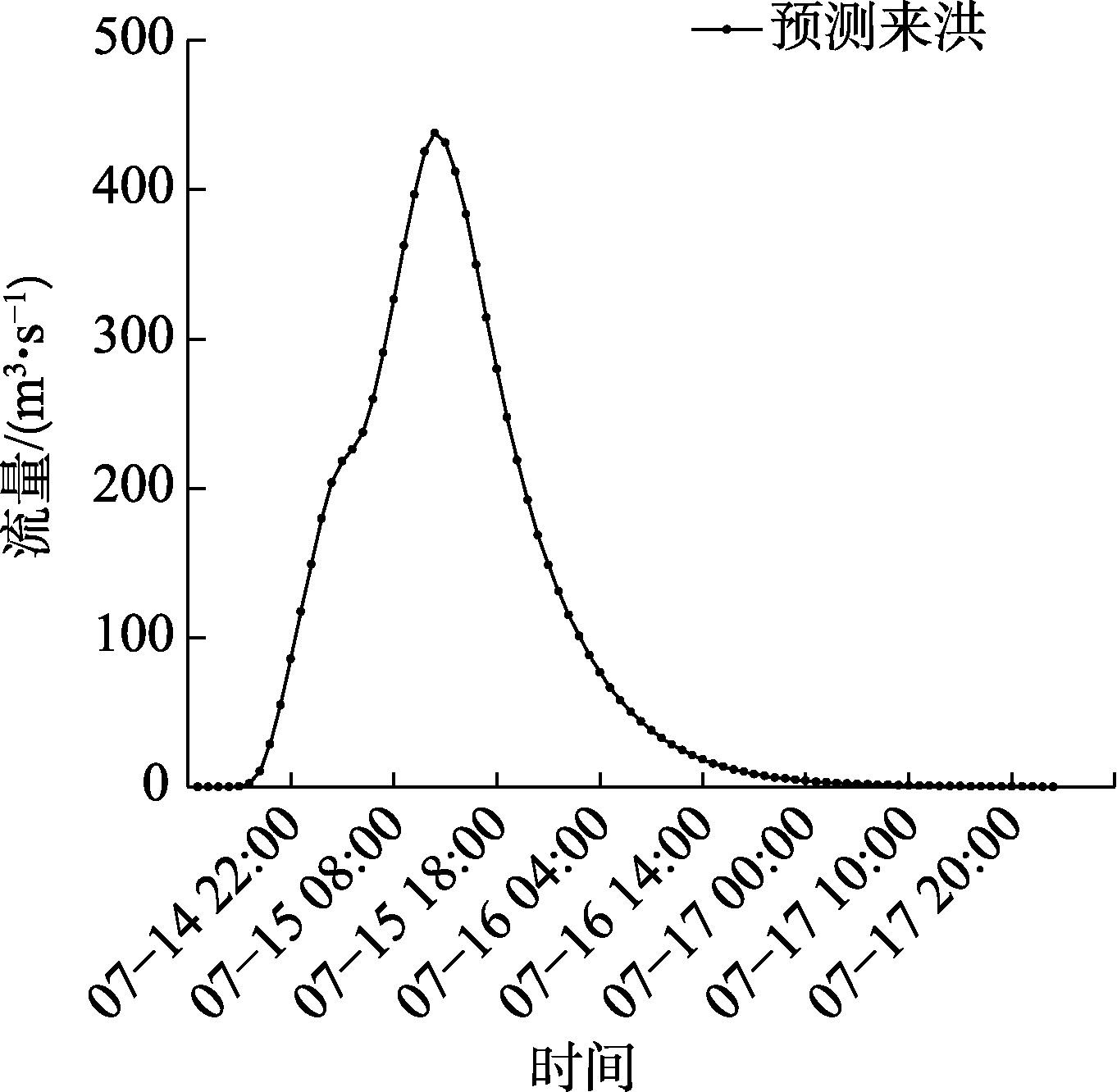
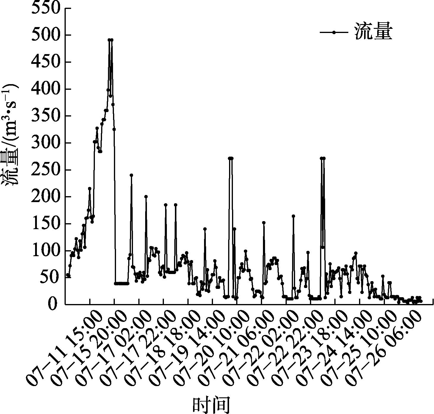
气候剧烈变化使得极端降水事件频发,流域防洪减灾能力面临前所未有的挑战。疏勒河流域气象、地形、水文和植被等要素的组合极易形成洪水,流域现有的防洪模型预测水平较低。为了解决疏勒河流域防洪需求,开发疏勒河流域数字孪生平台并提高平台的精细化预测与模拟水平,构建了以改进SCS产汇流模型和SRM融雪模型为核心,并以马斯京根河道演进模型耦合的洪水预测模型;在缺资料区采用SCS-CN扣损法计算净雨量,并以三角形概化单位线实现高效汇流;针对高寒融雪洪水,引入SRM并将日尺度细化为时段计算。将疏勒河上游划分为121个小流域单元,建立“数据底板-模型平台-知识平台”的数字孪生架构,实现模型注册、参数率定、实时驱动与滚动预报。以2023年“0711”洪水进行参数率定,洪峰流量误差6.8%,峰现时差2 h;2024年7月15日洪水实测应用中,平台提前72 h发布预警,预报洪峰438 m3·s-1、峰现时间7月15日12:00,实测分别为491 m3·s-1与14:00,误差满足《水文情报预报规范》SL250-2000要求。系统及时支撑水库预泄与下游避险,有效削减洪灾损失。研究提升了洪水预测精度,为智慧水利和韧性建设提供智能化解决方案。
安建民 , 张鹏举 , 张建新 , 史永杰 . 基于疏勒河数字孪生流域平台的洪水预测模型及应用[J]. 干旱区研究, 2025 , 42(11) : 2018 -2030 . DOI: 10.13866/j.azr.2025.11.06
Intensifying climate change has led to a surge in extreme precipitation events, posing unprecedented challenges to basin-wide flood prevention and mitigation. The unique combination of meteorological, topographical, hydrological and vegetation factors in the Shule River Basin makes it highly prone to flooding, yet existing forecasting models in the region exhibit low predictive skill. To address the flood control needs of the Shule River Basin,a digital twin platform was developed, and its precision in prediction and simulation was enhanced,this study establishes a coupled flood-prediction framework that centers on an improved SCS rainfall-runoff model and a Snowmelt Runoff Model (SRM), integrated with the Muskingum channel-routing scheme. In data-scarce areas, the SCS-CN loss method is employed to compute net rainfall, and a triangular unit hydrograph is adopted for efficient flow concentration. For alpine snowmelt-driven floods, the SRM is introduced and refined from a daily to a sub-daily time step. The upper Shule River is discretized into 121 sub-basins, and a digital-twin architecture comprising a “data foundation-model platform-knowledge platform” is built, enabling model registration, parameter calibration, real-time forcing and rolling forecasts. Model parameters were calibrated against the July 11, 2023 flood event; the simulated peak discharge showed an error of 6.8% and a timing lag of 2 h relative to observations. During the operational forecast for the July 15, 2024 flood, the platform issued an alert 72 h in advance, predicting a peak discharge of 438 m³·s-1 arriving at 12:00 on July 15, while the observed values were 491 m3·s-1 and 14:00, respectively. All errors meet the tolerance criteria specified in the Chinese national standard SL250-2000 for hydrological forecasting. The system provided timely support for reservoir pre-release and downstream evacuation, effectively reducing flood losses. The study advances flood-forecast accuracy and offers an intelligent solution for smart water management and resilient basin development.
表1 模型所需基础数据Tab. 1 Basic data required for the model |
| 模型类型 | 模型参数名称 | 初始值 | 单位 |
|---|---|---|---|
| 河道演进 模型 | 马斯京根法河道 分段数 | 1 | 个 |
| 马斯京根法计算 初始流量 | 0.5 | m3·s-1 | |
| 河道汇流马斯京 根法系数 | 0.4 | - | |
| 稳定河道洪水传 播历时 | 3 | h | |
| 径流曲线 模型 | CN值 | 75 | 个 |
| 初损系数 | 0.2 | - | |
| 土壤蓄水能力SW | 13 | mm | |
| 无因次单位线 | 1 | - | |
| 长度 | 62.477 | m | |
| 坡度 | 0.023 | % | |
| 流域当时的最大 可能滞留量 | 0 | m3·s-1 | |
| 融雪径流 模型 | 融雪径流系数 | 1 | - |
| 气温日融雪率 | 2 | mm·(℃·d)-1 | |
| 流域温度直减率 | 1 | ℃·(100m)-1 | |
| 降雨融雪度系数 | 1 | - | |
| 融雪临界温度 | 1 | ℃ | |
| 流量衰减系数 | 1 | - |
表2 昌马水库率定记录Tab. 2 Calibration record of Changma Reservoir |
| 洪号 | 实测 | 洪峰流量检验 | 模拟峰现时间 | |||||||||
|---|---|---|---|---|---|---|---|---|---|---|---|---|
| 起涨时间 | 起涨流量 /( m3·s-1 ) | 洪峰流量 /(m3·s-1) | 峰现时间 | 模拟洪峰 /(m3·s-1) | 许可误差/% | 合格否 | 模拟时间 | 许可 误差 | 合格否 | |||
| 20230711 | 2023-07-12 06:00 | 12.7 | 271.2 | 2023-07-12 11:00 | 291 | 6.8 | √ | 2023-07-12 13:00 | 2 h | √ | ||
表3 洪水预报接口设计Tab. 3 Interface design for flood prediction models |
| 模型类型 | 输入 | 输出 |
|---|---|---|
| 河道演进模型 | 开始时间 | 开始时间 结束时间 流域出口断面流量 过程 |
| 结束时间 | ||
| 第一断面第一时刻 初始流量 | ||
| 第一断面第二时刻 初始流量 | ||
| 第二断面第一时刻 初始流量 | ||
| 河道汇流马斯京根 法系数 | ||
| 稳定河道洪水传播 历时 | ||
| 径流曲线模型 | 开始时间 | 开始时间 结束时间 流域出口断面流量 过程 |
| 结束时间 | ||
| 流域面平均雨量 | ||
| CN值 | ||
| 初损系数 | ||
| 土壤湿润等级 | ||
| 无因次单位线 | ||
| 流域概化长度 | ||
| 流域坡度 | ||
| 流域当时的最大可 能滞留量 | ||
| 融雪径流模型 | 开始时间 | 开始时间 结束时间 流域出口断面流量 过程 |
| 结束时间 | ||
| 融雪径流系数 | ||
| 气温日融雪率 | ||
| 流域温度直减率 | ||
| 降雨融雪度系数 | ||
| 融雪临界温度 | ||
| 流量衰减系数 | ||
| 高度带 | ||
| 面降雨量 |
表4 昌马水库2024年7月15日洪峰预测值-实际值误差率Tab. 4 Error rate of predicted-actual peak flood values of Changma Reservoir on July 15, 2024 |
| 洪峰流量/(m3·s-1) | 洪峰到达时间 | 径流深/m | |
|---|---|---|---|
| 预测 | 438.03 | 7月15日12:00 | 13.01 |
| 实际 | 491 | 7月15日14:00 | 13.33 |
| 误差率/% | 10.80 | 8.33 | 1.61 |
| 规范许可误差率/% | 20 | 30 | 20 |
| [1] |
|
| [2] |
杨斐, 张文韬, 张飞民, 等. 1961—2022年祁连山气候特征及其变化[J]. 干旱区研究, 2024, 41(10): 1627-1638.
[
|
| [3] |
慕全鹏, 鲁克新, 杨光, 等. 沮河流域径流变化特征及归因分析[J]. 水力发电学报, 2022, 41(12): 80-89.
[
|
| [4] |
张存杰, 张思齐, 宁惠芳. 近60 a中国极端天气气候事件变化趋势及2023年特征分析[J]. 干旱气象, 2024, 42(4):536-552.
[
|
| [5] |
World Bank. Floods and Droughts: An EPIC Response to These Hazards in the Era of Climate Change[EB/OL]. (2021-06-17) [2025-07-22]. https://www.worldbank.org/en/news/feature/2021/06/17/floods-and-droughts-an-epic-response-to-these-hazards-in-the-era-of-climate-change.
|
| [6] |
|
| [7] |
|
| [8] |
|
| [9] |
刘荣华, 王雪梅, 刘晓婉, 等. 暴雨山洪模拟与预警模型研究进展与展望[J]. 中国防汛抗旱, 2025, 35(6): 1-10.
[
|
| [10] |
刘永强, 刘志辉. 基于Web的融雪洪水预警模型库系统研究与实现[J]. 干旱区研究, 2008, 25(1): 47-52.
[
|
| [11] |
|
| [12] |
张梅洁, 吕海深, 刘娣, 等. 耦合融雪的新安江模型在干旱区径流模拟研究[J]. 干旱区研究, 2022, 39(2): 379-387.
[
|
| [13] |
|
| [14] |
徐源浩, 邬强, 李常青, 等. 基于长短时记忆(LSTM)神经网络的黄河中游洪水过程模拟及预报[J]. 北京师范大学学报(自然科学版), 2020, 56(3): 387-393.
[
|
| [15] |
刘成帅, 孙悦, 胡彩虹, 等. 考虑产流模式空间分布的流域-城市复合系统洪水预报模型[J]. 水科学进展, 2023, 34(4): 530-540.
[
|
| [16] |
|
| [17] |
|
| [18] |
|
| [19] |
黄艳, 喻杉, 罗斌, 等. 面向流域水工程防灾联合智能调度的数字孪生长江探索[J]. 水利学报, 2022, 53(3): 253-269.
[
|
| [20] |
冶运涛, 蒋云钟, 梁犁丽, 等. 数字孪生流域: 未来流域治理管理的新基建新范式[J]. 水科学进展, 2022, 33(5): 683-704.
[
|
| [21] |
贾玲, 张百祖, 牛最荣, 等. 疏勒河上游径流变化与预测分析[J]. 干旱区研究, 2022, 39(5): 1588-1597.
[
|
| [22] |
季宗虎, 孙栋元, 牛最荣, 等. 疏勒河流域降水变化特征研究[J]. 干旱区研究, 2023, 40(10): 1583-1594.
[
|
| [23] |
李毅, 黄诗峰, 臧文斌, 等. 基于虚拟地理环境的数字孪生流域防洪应用技术探讨[J]. 遥感学报, 2024, 28(5): 1330-1339.
[
|
| [24] |
中华人民共和国水利部. 数字孪生水利工程建设技术导则[R]. 北京: 中华人民共和国水利部, 2022.
[ Ministry of Water Resources of the People’s Republic of China. Technical Guidelines for the Construction of Digital Twin Water Conservancy Projects[R]. Beijing: Ministry of Water Resources of the People’s Republic of China, 2022. ]
|
| [25] |
中华人民共和国水利部. 数字孪生流域建设技术大纲[R]. 北京: 中华人民共和国水利部, 2022.
[ Ministry of Water Resources of the People’s Republic of China. Technical Outline for the Construction of Digital Twin River Basins[R]. Beijing: Ministry of Water Resources of the People’s Republic of China, 2022. ]
|
| [26] |
周文慧, 钞小静. 黄河流域数字基础设施、经济发展韧性与生态环境保护的耦合协调发展分析: 基于三元系统耦合协调模型[J]. 干旱区资源与环境, 2023, 37(9): 1-9.
[
|
| [27] |
|
| [28] |
王井腾, 孙祥鹏, 张文明, 等. 珠江防汛“四预”平台建设及应用[J]. 中国水利, 2022(22): 39-42.
[
|
| [29] |
刘昌军, 吕娟, 任明磊, 等. 数字孪生淮河流域智慧防洪体系研究与实践[J]. 中国防汛抗旱, 2022, 32(1): 47-53.
[
|
| [30] |
赵杏英, 毛肖钰, 徐红权, 等. 数字流域多尺度空间地理信息模型构建及应用——以钱塘江流域为例[J]. 人民长江, 2021, 52(Suppl. 2): 293-297.
[
|
| [31] |
张建新. 数字孪生技术在疏勒河流域的应用和探讨[J]. 中国水利, 2023(23): 58-62.
[
|
| [32] |
张永明, 蒲秉华, 王鹏全, 等. 兰州新区SCS径流模型改进与应用研究[J]. 人民黄河, 2021, 43(3): 24-28.
[
|
| [33] |
U.S. Department of Agriculture, Soil Conservation Service. National Engineering Handbook, Section 4: Hydrology[M]. Rev. ed. Washington, D.C.: USDA-SCS, 1972.
|
| [34] |
|
| [35] |
夏军. 中国水文计算手册(第二版)[M]. 北京: 水利电力出版社, 2006.
[
|
| [36] |
杨飞, 刘博伦, 江恩慧, 等. 基于马斯京根法的多沙河流输沙演算[J]. 人民黄河, 2023, 45(11): 39-42.
[
|
/
| 〈 |
|
〉 |