
甘肃省土地利用转型时空格局演化及多情景模拟
|
王立媛(2001-),女,硕士研究生,主要从事土地利用相关研究. E-mail: wly0764@163.com |
收稿日期: 2024-11-12
修回日期: 2025-02-13
网络出版日期: 2025-08-14
基金资助
国家自然科学基金面上项目(71974002)
Evolution of spatiotemporal patterns and multiscenario simulation of land use transition in Gansu Province
Received date: 2024-11-12
Revised date: 2025-02-13
Online published: 2025-08-14
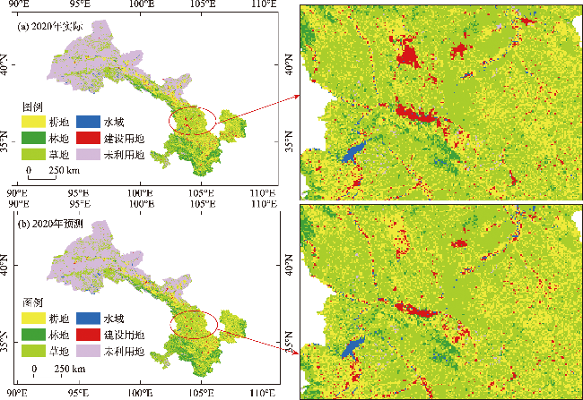
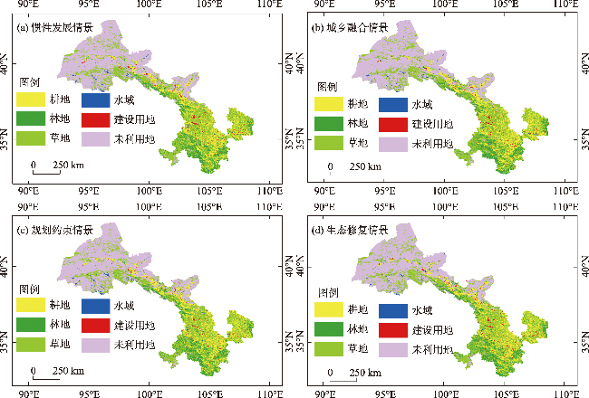
对兼具重要生态功能的欠发达地区土地利用转型态势进行探究,对于推动城乡融合、实现区域可持续发展具有重要意义。本文基于甘肃省2000—2020年5期土地利用数据,从时空维度分析土地利用类型数量分布、空间布局及相互转移情况,并采用FLUS模型,模拟了2035年惯性发展、城乡融合、规划约束和生态修复四种情景下土地利用转型情况。结果表明:(1) 2000—2020年,甘肃省土地利用类型以耕地、草地和未利用地为主,且不同地类在空间分布上呈现出显著的区域异质性;其综合土地利用动态度呈先上升后下降再上升的趋势。(2) 受到西部大开发战略的持续推进和退耕还林还草等政策的影响,甘肃省土地利用转型主要表现在耕地向草地、林地转移,以及建设用地向耕地、草地转移。(3) 在城乡融合和规划约束两种情景下,土地利用模拟结果较为合理,兼顾了耕地保护和区域生态环境修复,可满足未来发展需求,为甘肃省未来国土空间治理提供了参考。
王立媛 , 张勇 . 甘肃省土地利用转型时空格局演化及多情景模拟[J]. 干旱区研究, 2025 , 42(4) : 695 -707 . DOI: 10.13866/j.azr.2025.04.11
Exploring the transition situation of land use in ecologically significant but underdeveloped areas is crucial for promoting urban-rural integration and achieving regional sustainable development. Using the land use data from five time points in Gansu Province from 2000 to 2020, this study analyzed the quantitative distribution, spatial patterns, and mutual transfer of land use types. The Future Land Use Simulation model was used to simulate the land use transformation under four scenarios of inertia development, urban-rural integration, planning constraints, and ecological restoration in 2035. The study found that: (1) The main land use types in Gansu Province are cultivated land, grassland, and unused land, exhibiting significant regional heterogeneity in spatial distribution. The comprehensive land use dynamics initially increased, then decreased, before increasing again. (2) Under the influence of the continuous promotion of the Western Development Strategy and the policy of returning farmland to forest and grassland, the land use transition in the Gansu Province is mainly manifested in the transfer of cultivated land to grassland and woodland, and the transfer of construction land to cultivated land and grassland. (3) Under the two scenarios of urban-rural integration and planning constraints, the results of land use simulation are reasonable, considering cultivated land protection and regional ecological environment restoration, which can meet the needs of future development. This study provides a valuable reference for land governance and spatial planning in Gansu Province.
表1 数据来源Tab. 1 Data source information |
| 数据类型 | 数据名称 | 数据精度 | 数据来源 |
|---|---|---|---|
| 土地利用数据 | 土地利用数据 | 30 m | 中国科学院资源环境科学与数据中心 (http://www.resdc.cn) |
| 限制因子 | 水域 | 1 km | |
| 自然保护区 | 1 km | ||
| 社会经济因素 | 人口密度 | 1 km | |
| GDP | 1 km | ||
| 自然环境因素 | 高程(DEM) | 30 m | 地理空间数据云(https://www.gscloud.cn) |
| 坡度 | 30 m | 根据DEM数据由ArcGIS生成 | |
| 坡向 | 30 m | ||
| 年降水量 | 1 km | 国家青藏高原科学数据中心 | |
| 年平均气温 | 1 km | ||
| 交通可达因素 | 到河流距离 | 1 km | 1:1000000全国基础地理数据库,由ArcGIS生成 |
| 到国道距离 | 1 km | ||
| 到省道距离 | 1 km | ||
| 到高速距离 | 1 km | ||
| 到铁路距离 | 1 km | ||
| 行政区划数据 | 甘肃省行政边界 | - | 地理空间数据云(https://www.gscloud.cn) |
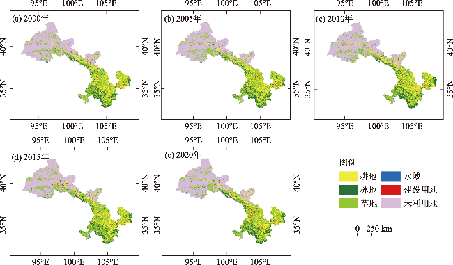
表2 甘肃省土地利用类型面积变化Tab. 2 Changes in land use types and areas in Gansu Province |
| 土地利用 类型 | 2000年 | 2005年 | 2010年 | 2015年 | 2020年 | |||||||||
|---|---|---|---|---|---|---|---|---|---|---|---|---|---|---|
| 面积/km2 | 占比/% | 面积/km2 | 占比/% | 面积/km2 | 占比/% | 面积/km2 | 占比/% | 面积/km2 | 占比/% | |||||
| 耕地 | 65595 | 15.42 | 65509 | 15.39 | 65057 | 15.29 | 64888 | 15.25 | 63883 | 15.01 | ||||
| 林地 | 37636 | 8.84 | 38156 | 8.97 | 38530 | 9.05 | 38533 | 9.06 | 38517 | 9.05 | ||||
| 草地 | 142700 | 33.54 | 142923 | 33.59 | 143014 | 33.61 | 142952 | 33.59 | 143664 | 33.76 | ||||
| 水域 | 3304 | 0.78 | 3293 | 0.77 | 3545 | 0.83 | 3535 | 0.83 | 3841 | 0.90 | ||||
| 建设用地 | 3541 | 0.83 | 3770 | 0.89 | 4283 | 1.01 | 4745 | 1.12 | 5564 | 1.31 | ||||
| 未利用地 | 172744 | 40.60 | 171870 | 40.39 | 171092 | 40.21 | 170868 | 40.16 | 170031 | 39.96 | ||||
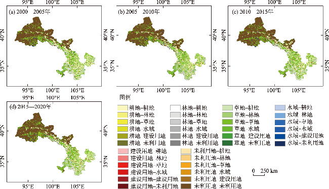
表3 甘肃省土地利用动态变化度Tab. 3 Dynamic changes in land use in Gansu Province /% |
| 土地利用类型 | 耕地 | 林地 | 草地 | 水域 | 建设用地 | 未利用地 | 综合动态度 |
|---|---|---|---|---|---|---|---|
| 2000—2005年 | -0.03 | 0.28 | 0.03 | -0.06 | 1.29 | -0.10 | 1.79 |
| 2005—2010年 | -0.14 | 0.20 | 0.01 | 1.53 | 2.73 | -0.09 | 4.69 |
| 2010—2015年 | -0.05 | 0.007 | -0.01 | -0.06 | 2.15 | -0.03 | 2.30 |
| 2015—2020年 | -0.31 | -0.01 | 0.10 | 1.73 | 3.46 | -0.10 | 5.70 |
表4 2000—2020年不同阶段甘肃省土地利用转移矩阵Tab. 4 Land use transfer matrix in Gansu Province at different stages from 2000 to 2020 /km2 |
| 耕地 | 林地 | 草地 | 水域 | 建设用地 | 未利用地 | |
|---|---|---|---|---|---|---|
| 2000—2005年 | ||||||
| 耕地 | 63890.9 | 250.9 | 1208.1 | 10.8 | 171.5 | 61.1 |
| 林地 | 83.9 | 37399.5 | 147.3 | 1.7 | 13.2 | 8.3 |
| 草地 | 828.3 | 503.2 | 141155.3 | 13.2 | 29.8 | 135.5 |
| 水域 | 14.0 | 1.3 | 29.4 | 3220.7 | 1.9 | 35.6 |
| 建设用地 | 12.0 | 1.4 | 6.8 | 0.6 | 3547.7 | 0.6 |
| 未利用地 | 677.1 | 18.2 | 339.9 | 45.2 | 33.5 | 171622.8 |
| 2005—2010年 | ||||||
| 耕地 | 62075.8 | 305.5 | 2343.0 | 36.4 | 512.6 | 232.5 |
| 林地 | 176.5 | 37613.1 | 268.7 | 22.9 | 18.1 | 74.8 |
| 草地 | 1753.7 | 545.8 | 138923.2 | 63.9 | 112.0 | 1486.5 |
| 水域 | 42.2 | 6.6 | 35.5 | 3100.1 | 6.8 | 100.8 |
| 建设用地 | 221.3 | 8.3 | 26.0 | 1.5 | 3517.2 | 23.1 |
| 未利用地 | 785.4 | 69.2 | 1377.9 | 318.7 | 145.2 | 169165.4 |
| 2010—2015年 | ||||||
| 耕地 | 63944.2 | 60.0 | 678.3 | 24.6 | 287.7 | 59.5 |
| 林地 | 60.7 | 38238.7 | 222.1 | 4.4 | 6.3 | 15.5 |
| 草地 | 627.5 | 213.7 | 141814.9 | 28.5 | 61.7 | 227.5 |
| 水域 | 12.1 | 2.1 | 18.7 | 3389.0 | 2.7 | 118.5 |
| 建设用地 | 40.0 | 2.0 | 12.2 | 0.9 | 4254.7 | 2.1 |
| 未利用地 | 202.8 | 15.9 | 203.5 | 86.7 | 131.7 | 170441.7 |
| 2015—2020年 | ||||||
| 耕地 | 61238.6 | 199.9 | 2362.3 | 54.7 | 558.9 | 468.1 |
| 林地 | 139.3 | 37711.9 | 576.2 | 13.7 | 44.9 | 40.9 |
| 草地 | 1716.1 | 489.7 | 139259.5 | 66.8 | 296.5 | 1098.8 |
| 水域 | 38.1 | 11.1 | 58.9 | 3313.5 | 17.0 | 92.0 |
| 建设用地 | 270.2 | 14.5 | 104.3 | 8.0 | 4252.3 | 95.4 |
| 未利用地 | 477.8 | 84.5 | 1291.0 | 381.0 | 394.8 | 168223.2 |
| [1] |
龙花楼. 论土地利用转型与乡村转型发展[J]. 地理科学进展, 2012, 31(2): 131-138.
[
|
| [2] |
|
| [3] |
孙善良, 张小平. 陕西省土地利用转型时空演变及其生态环境效应分析[J]. 水土保持研究, 2021, 28(6): 356-363, 370.
[
|
| [4] |
|
| [5] |
|
| [6] |
|
| [7] |
|
| [8] |
|
| [9] |
范清瑶, 夏卫生, 莫成鑫, 等. 基于“三生空间”的土地利用转型时空演变及其碳排放效应研究——以福建省为例[J]. 生态环境学报, 2023, 32(12): 2183-2193.
[
|
| [10] |
|
| [11] |
张梦圆, 荣丽华, 李伊彤, 等. 基于“三生”空间的农牧交错区城市土地利用转型及生态环境效应分析——以包头市为例[J]. 干旱区地理, 2023, 46(6): 958-967.
[
|
| [12] |
董冬, 罗毅, 顾康康. “三生空间”视角下长三角城市群土地利用转型生态环境效应时空分异及驱动力[J]. 长江流域资源与环境, 2023, 32(8): 1664-1676.
[
|
| [13] |
张超正, 陈丹玲, 靳亚亚, 等. 基于经济社会发展阶段转型的土地利用变化驱动因素识别——以长江中游地区为例[J]. 长江流域资源与环境, 2023, 32(12): 2528-2541.
[
|
| [14] |
刘宝涛. 长三角城市群建设用地转型时空分异及驱动因子识别[J]. 南通大学学报(社会科学版), 2023, 39(3): 43-56.
[
|
| [15] |
瞿诗进, 李全峰, 胡守庚. 突变视角下城镇建设用地形态演变与转型分区——以长江中游地区为例[J]. 地理与地理信息科学, 2023, 39(1): 38-46.
[
|
| [16] |
马丽君, 程久苗, 程建, 等. 土地利用隐性转型影响因素分析[J]. 中国土地科学, 2019, 33(7): 81-90.
[
|
| [17] |
宋家鹏, 陈松林. 福建省土地利用隐性形态与土地生态安全耦合协调分析[J]. 水土保持研究, 2020, 27(4): 301-307.
[
|
| [18] |
冯新惠, 李艳, 余迩, 等. 环太湖城市群土地利用转型及其生态环境效应[J]. 长江流域资源与环境, 2023, 32(6): 1238-1253.
[
|
| [19] |
汤江龙, 朱健计, 王林燕, 等. 贵溪市土地利用转型对生态系统服务价值影响的多情景模拟[J]. 环境科学与技术, 2022, 45(6): 212-223.
[
|
| [20] |
龚亚男, 韩书成, 时晓标, 等. 广东省“三生空间”用地转型的时空演变及其生态环境效应[J]. 水土保持研究, 2020, 27(3): 203-209.
[
|
| [21] |
田俊峰, 王彬燕, 王士君. 东北地区土地利用转型特征测度与机制探索[J]. 经济地理, 2020, 40(9): 184-195.
[
|
| [22] |
|
| [23] |
|
| [24] |
刘强, 杨众养, 陈毅青, 等. 基于CA-Markov多情景模拟的海南岛土地利用变化及其生态环境效应[J]. 生态环境学报, 2021, 30(7): 1522-1531.
[
|
| [25] |
张晓荣, 李爱农, 南希, 等. 基于FLUS模型和SD模型耦合的中巴经济走廊土地利用变化多情景模拟[J]. 地球信息科学学报, 2020, 22(12): 2393-2409.
[
|
| [26] |
王端睿, 毛德华, 王宗明, 等. 东北地区土地覆被格局变化模拟: 基于CLUE-S和Markov-CA模型的对比分析[J]. 地理科学, 2024, 44(2): 329-339.
[
|
| [27] |
常铭鑫, 曾晨, 解鹏, 等. 多情景下的土地利用模拟与特征分析: 以武汉市为例[J]. 华中农业大学学报, 2023, 42(4): 74-85.
[
|
| [28] |
张潇, 谷人旭. 土地利用冲突的时空格局刻画与多情景模拟研究——以长江三角洲城市群为例[J]. 地理研究, 2022, 41(5): 1311-1326.
[
|
| [29] |
杜文星, 赵志忠, 吕晓, 等. 城乡土地利用转型研究进展及展望[J]. 土壤通报, 2021, 52(2): 493-504.
[
|
| [30] |
商梦雅, 李江. 农村宅基地制度对农户主观获得感、幸福感、安全感的影响[J]. 西北农林科技大学学报(社会科学版), 2022, 22(4): 60-71.
[
|
| [31] |
魏乐, 周亮, 孙东琪, 等. 黄河流域城市群扩张的时空格局演化及情景模拟——以呼包鄂榆城市群为例[J]. 地理研究, 2022, 41(6): 1610-1622.
[
|
| [32] |
张恩月, 郑君焱, 苏迎庆, 等. 基于情景模拟的流域低碳土地利用格局优化研究——以汾河流域为例[J]. 干旱区研究, 2023, 40(2): 203-212.
[
|
| [33] |
金梦婷, 徐丽萍, 徐权. 基于FLUS-Markov模型的多情景景观生态风险评价与预测——以南疆克州为例[J]. 干旱区研究, 2021, 38(6): 1793-1804.
[
|
| [34] |
刘小琼, 何鹏飞, 韩继财, 等. 长江经济带生态安全格局演化及多情景模拟预测[J]. 经济地理, 2023, 43(12): 192-203.
[
|
| [35] |
苏泽琛, 邵战林. 干旱区土地利用变化对耕地空间的影响及预测——以昌吉市为例[J]. 干旱区研究, 2024, 41(11): 1936-1945.
[
|
/
| 〈 |
|
〉 |