
基于MSPA模型和电路理论的晋西北国土空间生态修复关键区域识别
|
李可璇(1998-),女,硕士研究生,主要从事国土空间生态修复研究. E-mail: 1195797486@qq.com |
收稿日期: 2024-04-08
修回日期: 2024-06-19
网络出版日期: 2025-08-13
基金资助
国家自然科学基金项目(41701108)
山西省哲学社会科学规划课题(2023YY220)
Identification of the key regions of spatial ecological restoration in the Northwest Shanxi based on the MSPA model and circuit theory
Received date: 2024-04-08
Revised date: 2024-06-19
Online published: 2025-08-13
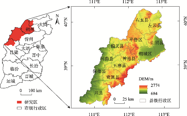
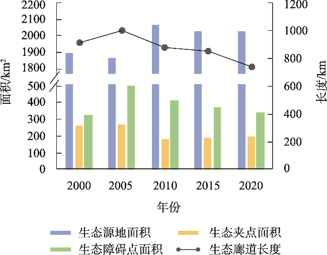
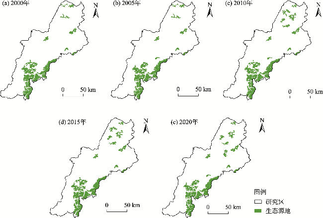
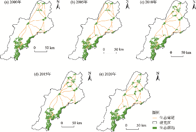
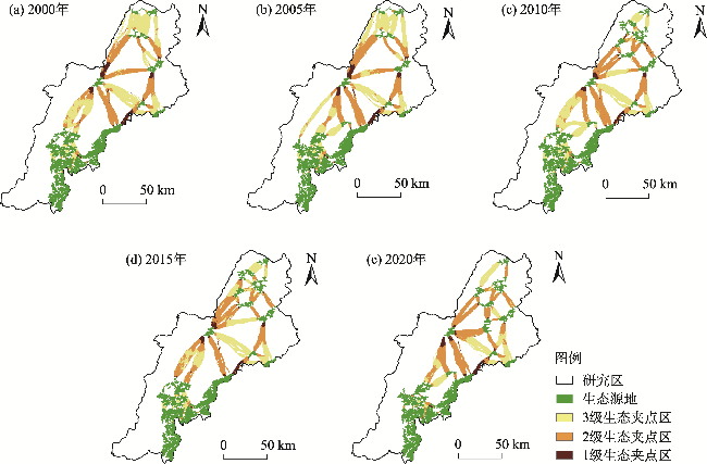
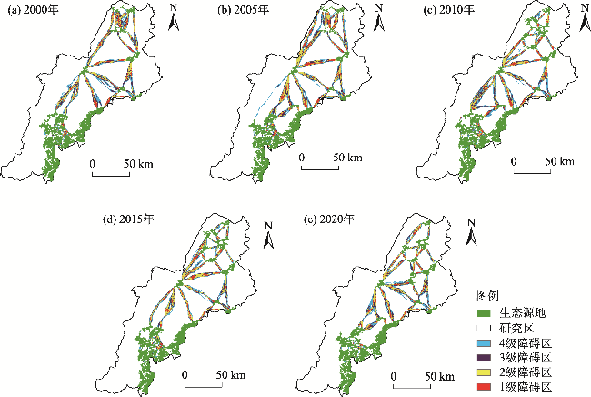
国土空间生态修复是落实国家生态文明战略的重要举措,生态修复关键区域识别是国土空间生态修复的关键一环,是科学开展生态修复的关键和难点,对维护区域生态安全具有重要的意义,但当前我国国土空间生态修复关键区域识别相关理论研究滞后于实践工作。本文以晋西北为研究区,通过形态学空间分析(Morphological Spatial Analysis,MSPA)模型结合生态系统服务价值识别生态源地,采用电路理论识别与提取生态廊道,在此基础上,进行生态修复关键区域识别及时空演变规律分析,从而给出对应生态修复策略。结果显示:2000—2020年晋西北生态源地数量及面积均呈现增加的趋势,20 a间生态源地总面积从1898.43 km2增长到2026.17 km2,空间分布呈现南部集中连片,北部零散分布的特点;生态廊道数量与长度先增加后减少,空间分布上南部保持短且密集,中部和北部由长且稀疏趋向短且密集。生态修复关键区域中,生态夹点面积总体下降,20 a间从262.89 km2下降至194.34 km2,夹点普遍分布于生态廊道的两端邻近生态源地的区域,主要分布在偏关县、平鲁区、神池县和朔城区;生态障碍点整体呈现增加趋势,20 a间从324.61 km2增长到504.72 km2,随后又减少到338.86 km2,障碍点普遍分布于生态廊道的中段,由聚集分布转变为均匀分布。研究综合生态修复关键区域时空演变特征及研究区生态本底,提出针对性生态修复策略,即加强夹点和障碍点的小流域、小区域治理,减少人为干扰,以期为区域国土空间生态修复工作提供参考。
李可璇 , 张蕾 , 李豪 , 张恩月 , 李育桢 , 宋彩云 , 刘庚 . 基于MSPA模型和电路理论的晋西北国土空间生态修复关键区域识别[J]. 干旱区研究, 2024 , 41(9) : 1593 -1604 . DOI: 10.13866/j.azr.2024.09.15
Ecological restoration of land space is an important measure to implement the national strategy of ecological civilization. The identification of key areas of ecological restoration is a key link to the ecological restoration of land space and is difficult to carry out scientifically. Maintaining regional ecological security is of great significance. However, at present, the research on the key region identification of ecological restoration in our country lags in practice. In this paper, based on the morphological spatial analysis (MSPA) model and the value of ecosystem services, the ecological corridor was identified and extracted by circuit theory, the key areas of ecological restoration were identified, the space-time evolution law was analyzed, and the corresponding ecological restoration strategies were provided. The results showed that from 2000 to 2020, the quantity and area of ecological source areas in Northwest Shanxi increased, and the total source areas enhanced from 1898.43 to 2026.17 km2 in 20 years. The number and length of eco-corridors first elevated and then decreased, and their spatial distribution was short and dense in the south, middle, and north. In the key areas of ecological restoration, the area of ecological pinch declined from 262.89 to 194.34 km2 in the past 20 years; the ecological barrier sites in Pianguan County, Pinglu District, Shenchi County, and Shuocheng District enhanced from 324.61 to 504.72 km2 and then reduced to 338.86 km2; the obstacle points were generally distributed in the middle of the ecological corridor, and their distribution changed from aggregation to uniformity. The paper studies the space-time evolution characteristics of the critical ecological restoration areas and the ecological background of the study areas. It also puts forward the targeted ecological restoration strategies, namely, strengthening the management of small watersheds and areas at pinch and obstacle points, and reducing human disturbance, to provide reference for regional land space ecological restoration.
表1 晋西北生态系统服务价值当量Tab. 1 Equivalent value of ecosystem services in Northwest Shanxi |
| 生态系统服务 | 耕地 | 林地 | 草地 | 水域 | 建设用地 | 未利用土地 | |
|---|---|---|---|---|---|---|---|
| 供给服务 | 食物生产 | 0.85 | 0.25 | 0.23 | 0.66 | 0.00 | 0.01 |
| 原料生产 | 0.40 | 0.58 | 0.34 | 0.37 | 0.00 | 0.03 | |
| 水资源供给 | 0.02 | 0.30 | 0.19 | 5.44 | 0.00 | 0.02 | |
| 调节服务 | 气体调节 | 0.67 | 1.91 | 1.21 | 1.34 | 0.00 | 0.11 |
| 气候调节 | 0.36 | 5.71 | 3.19 | 2.95 | 0.00 | 0.10 | |
| 净化环境 | 0.10 | 1.67 | 1.05 | 4.58 | 0.00 | 0.31 | |
| 水文调节 | 0.27 | 3.74 | 2.34 | 63.24 | 0.00 | 0.21 | |
| 支持服务 | 土壤保持 | 1.03 | 2.32 | 1.47 | 1.62 | 0.00 | 0.13 |
| 维持养分循环 | 0.12 | 0.18 | 0.11 | 0.13 | 0.00 | 0.01 | |
| 生物多样性 | 0.13 | 2.12 | 1.34 | 5.21 | 0.00 | 0.12 | |
| 文化服务 | 美学景观 | 0.06 | 0.93 | 0.59 | 3.31 | 0.00 | 0.05 |
表2 阻力因素赋值Tab. 2 Assignment of resistance factor |
| 阻力因子 | 1级 | 2级 | 3级 | 4级 | 5级 | 权重 |
|---|---|---|---|---|---|---|
| 高程/m | <1100 | 1100~1300 | 1300~1500 | 1500~1700 | >1700 | 0.08 |
| 坡度/(°) | 0~2 | 2~6 | 6~15 | 15~25 | >25 | 0.07 |
| 土地利用类型 | 林地、水域 | 草地 | 耕地 | 未利用土地 | 建设用地 | 0.23 |
| NDVI | >0.8 | 0.6~0.8 | 0.4~0.6 | 0.2~0.4 | <0.2 | 0.22 |
| 距道路距离/m | >4000 | 3000~4000 | 2000~3000 | 1000~2000 | 0~1000 | 0.12 |
| 距居民点距离/m | >2000 | 1500~2000 | 1000~1500 | 500~1000 | <500 | 0.09 |
| 距水体距离/m | <1000 | 1000~2000 | 2000~3000 | 3000~4000 | >4000 | 0.19 |
| [1] |
曹宇, 王嘉怡, 李国煜. 国土空间生态修复: 概念思辨与理论认知[J]. 中国土地科学, 2019, 33(7): 1-10.
[
|
| [2] |
傅伯杰. 国土空间生态修复亟待把握的几个要点[J]. 中国科学院院刊, 2021, 36(1): 64-69.
[
|
| [3] |
白中科. 国土空间生态修复若干重大问题研究[J]. 地学前缘, 2021, 28(4): 1-13.
[
|
| [4] |
彭建, 赵会娟, 刘焱序, 等. 区域生态安全格局构建研究进展与展望[J]. 地理研究, 2017, 36(3): 407-419.
[
|
| [5] |
潘竟虎, 刘晓. 基于空间主成分和最小累积阻力模型的内陆河景观生态安全评价与格局优化——以张掖市甘州区为例[J]. 应用生态学报, 2015, 26(10): 3126-3136.
[
|
| [6] |
包玉斌, 王耀宗, 路锋, 等. 六盘山区国土空间生态安全格局构建与分区优化[J]. 干旱区研究, 2023, 40(7): 1172-1183.
[
|
| [7] |
李权荃, 金晓斌, 张晓琳, 等. 基于景观生态学原理的生态网络构建方法比较与评价[J]. 生态学报, 2023, 43(4): 1461-1473.
[
|
| [8] |
马晓琳, 郭莎莎, 徐扬, 等. 生态脆弱区生态安全格局构建研究[J]. 生态学报, 2023, 43(22): 9500-9513.
[
|
| [9] |
郑群明, 扈嘉辉, 申明智. 基于MSPA和MCR模型的湖南省生态网络构建[J]. 湖南师范大学自然科学学报, 2021, 44(5): 1-10.
[
|
| [10] |
|
| [11] |
覃彬桂, 林伊琳, 赵俊三, 等. 基于InVEST模型和电路理论的昆明市国土空间生态修复关键区域识别[J]. 中国环境科学, 2023, 43(2): 809-820.
[
|
| [12] |
李倩瑜, 唐立娜, 邱全毅, 等. 基于形态学空间格局分析和最小累积阻力模型的城市生态安全格局构建——以厦门市为例[J]. 生态学报, 2024, 44(6): 2284-2294.
[
|
| [13] |
|
| [14] |
朱琪, 袁泉, 于大炮, 等. 基于电路理论的东北森林带生态安全网络构建[J]. 生态学杂志, 2021, 40(11): 3463-3473.
[
|
| [15] |
曹秀凤, 刘兆顺, 李淑杰, 等. 基于生态安全格局的国土空间生态修复关键区域识别——以吉林省松原市为例[J]. 中国环境科学, 2022, 42(6): 2779-2787.
[
|
| [16] |
|
| [17] |
刘春飞, 刘平辉, 朱传民. 基于电路理论的生态安全格局构建的生态以赣州市为例[J]. 湖北农业科学, 2022, 61(23): 30-37.
[
|
| [18] |
|
| [19] |
张玥, 许端阳, 李霞, 等. 中-老交通走廊核心区生态廊道构建与关键节点识别[J]. 生态学报, 2020, 40(6): 1933-1943.
[
|
| [20] |
彭建, 李慧蕾, 刘焱序, 等. 雄安新区生态安全格局识别与优化策略[J]. 地理学报, 2018, 73(4): 701-710.
[
|
| [21] |
程纪元. 基于生态网络的长治市矿区生态修复策略研究[D]. 北京: 中国地质大学, 2021.
[
|
| [22] |
刘凤莲, 刘艳. 基于生态安全格局的高原城市生态修复关键区域识别——以昆明市为例[J]. 国土资源科技管理, 2023, 40(3): 17-30.
[
|
| [23] |
向爱盟, 岳启发, 赵筱青, 等. 西南喀斯特山区国土空间生态修复关键区识别及修复分区——以开远市为例[J]. 中国环境科学, 2023, 43(12): 6571-6582.
[
|
| [24] |
薛强, 路路, 牛韧, 等. 基于地质灾害敏感性的生态安全格局关键区识别与修复——以济南市为例[J]. 生态学报, 2021, 41(22): 9050-9063.
[
|
| [25] |
古雄. 基于生态网络构建的县域国土空间生态保护与修复策略研究[D]. 南昌: 江西财经大学, 2022.
[
|
| [26] |
温雪静, 周智, 张美丽, 等. 太行山区国土空间生态修复关键区域识别——以唐县为例[J]. 中国生态农业学报(中英文), 2021, 29(12): 2093-2106.
[
|
| [27] |
张美丽, 李智, 张益琛, 等. 基于生态安全格局的国土空间生态修复关键区域识别——以河北省阜平县为例[J]. 水土保持研究, 2021, 28(3): 299-307, 3.
[
|
| [28] |
付扬军, 师学义. 基于小流域尺度的县域国土空间生态修复分区——以山西汾河上游为例[J]. 自然资源学报, 2023, 38(5): 1225-1239.
[
|
| [29] |
孙茂森, 王让会, 宁虎森. 阿克苏河流域生态网络构建[J]. 干旱区研究, 2023, 40(9): 1509-1516.
[
|
| [30] |
郑群明, 申明智, 钟林生. 普达措国家公园生态安全格局构建[J]. 生态学报, 2021, 41(3): 874-885.
[
|
| [31] |
祁强强, 徐占军. 生态安全格局时空演变分析——以太原城市群为例[J]. 中国环境科学, 2023, 43(11): 5987-5997.
[
|
| [32] |
张海铃, 叶长盛, 胡梦姗. 基于生态安全格局的环鄱阳湖城市群生态修复关键区域识别及修复策略[J]. 水土保持研究, 2023, 30(2): 393-402.
[
|
| [33] |
朱东红. 晋西北地区生态环境质量评价研究[D]. 太原: 山西大学, 2003.
[
|
| [34] |
薛占金, 秦作栋, 程芳琴. 晋西北地区土地沙漠化时空格局及其驱动因素[J]. 中国环境科学, 2020, 40(12): 5428-5435.
[
|
| [35] |
谢高地, 张彩霞, 张雷明, 等. 基于单位面积价值当量因子的生态系统服务价值化方法改进[J]. 自然资源学报, 2015, 30(8): 1243-1254.
[
|
| [36] |
宋利利, 秦明周. 整合电路理论的生态廊道及其重要性识别[J]. 应用生态学报, 2016, 27(10): 3344-3352.
[
|
| [37] |
|
| [38] |
杨园园. 晋西北生态脆弱区土地生态安全评价及影响因素研究[D]. 太原: 山西财经大学, 2023.
[
|
/
| 〈 |
|
〉 |