
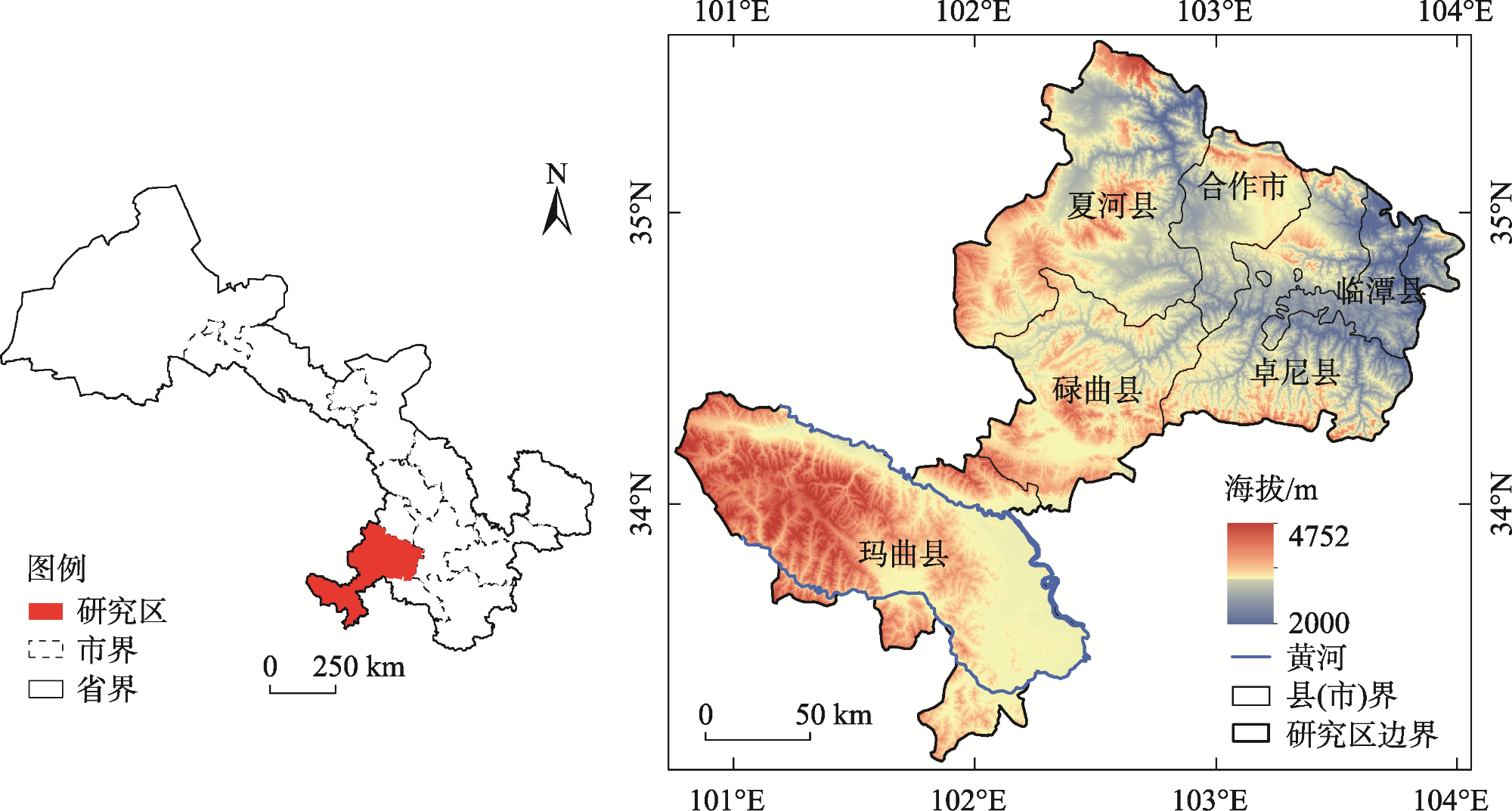
甘南黄河上游植被覆盖度时空变化与地形因子的关系
|
张起鹏(1980-),男,博士,副教授,主要从事景观生态学与3S技术应用. E-mail: qp0720aaa@163.com |
收稿日期: 2024-07-14
修回日期: 2024-08-18
网络出版日期: 2025-08-13
基金资助
国家自然科学基金项目(32060279)
Relationship between temporal and spatial changes of vegetation coverage and topographic factors in the Upper Yellow River in Gannan
Received date: 2024-07-14
Revised date: 2024-08-18
Online published: 2025-08-13
张起鹏 , 路红娥 , 赵頔琛 , 卓玛兰草 . 甘南黄河上游植被覆盖度时空变化与地形因子的关系[J]. 干旱区研究, 2025 , 42(3) : 523 -522 . DOI: 10.13866/j.azr.2025.03.12
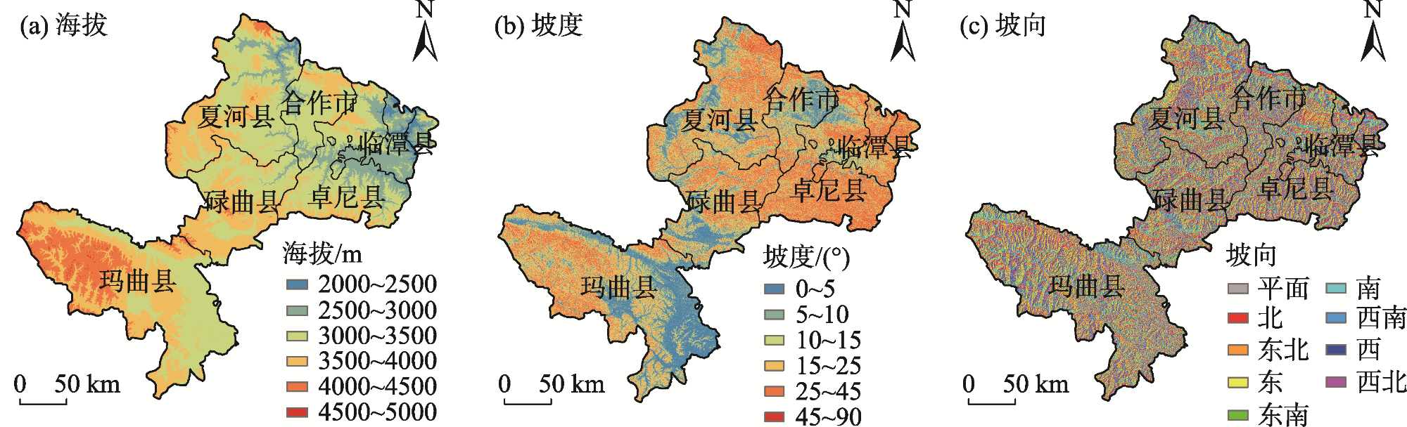
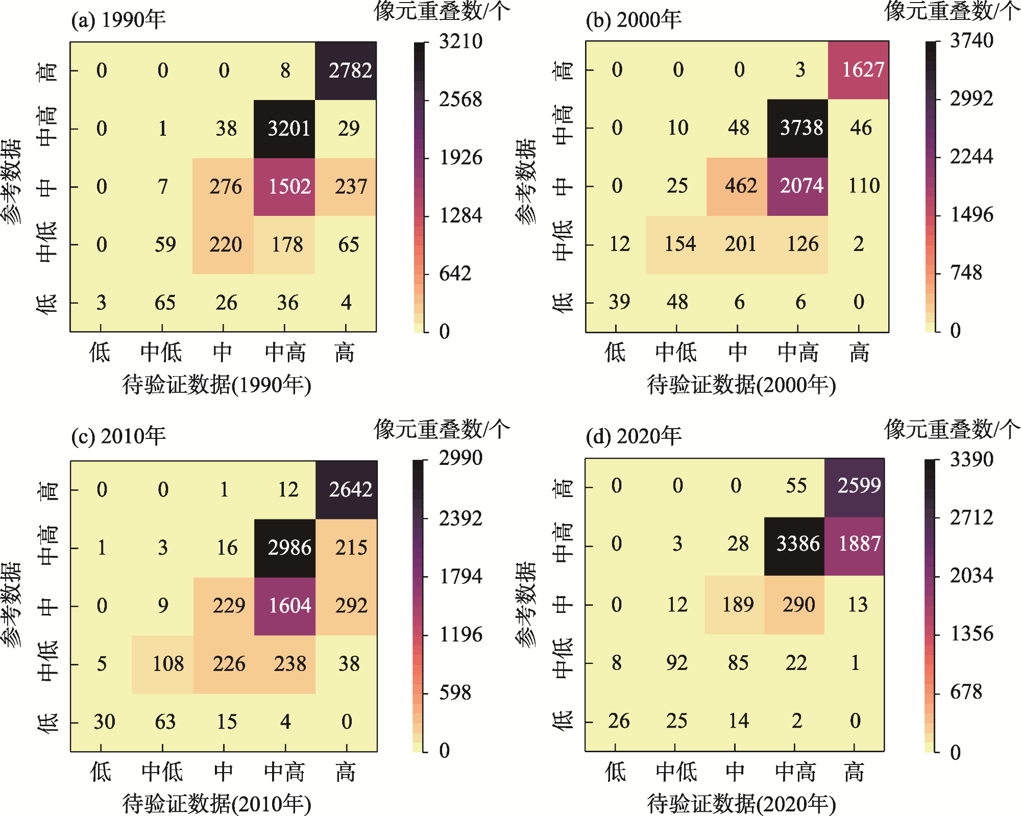
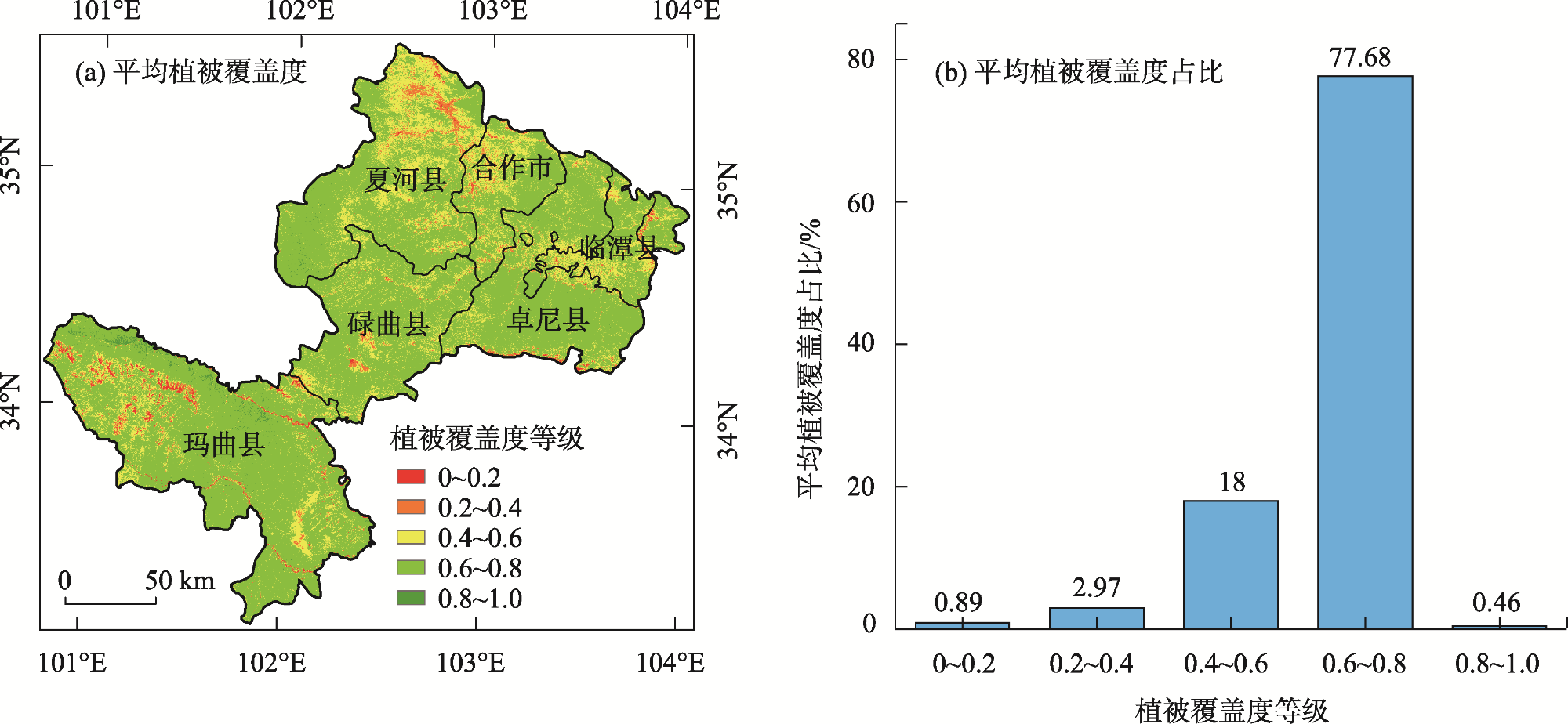
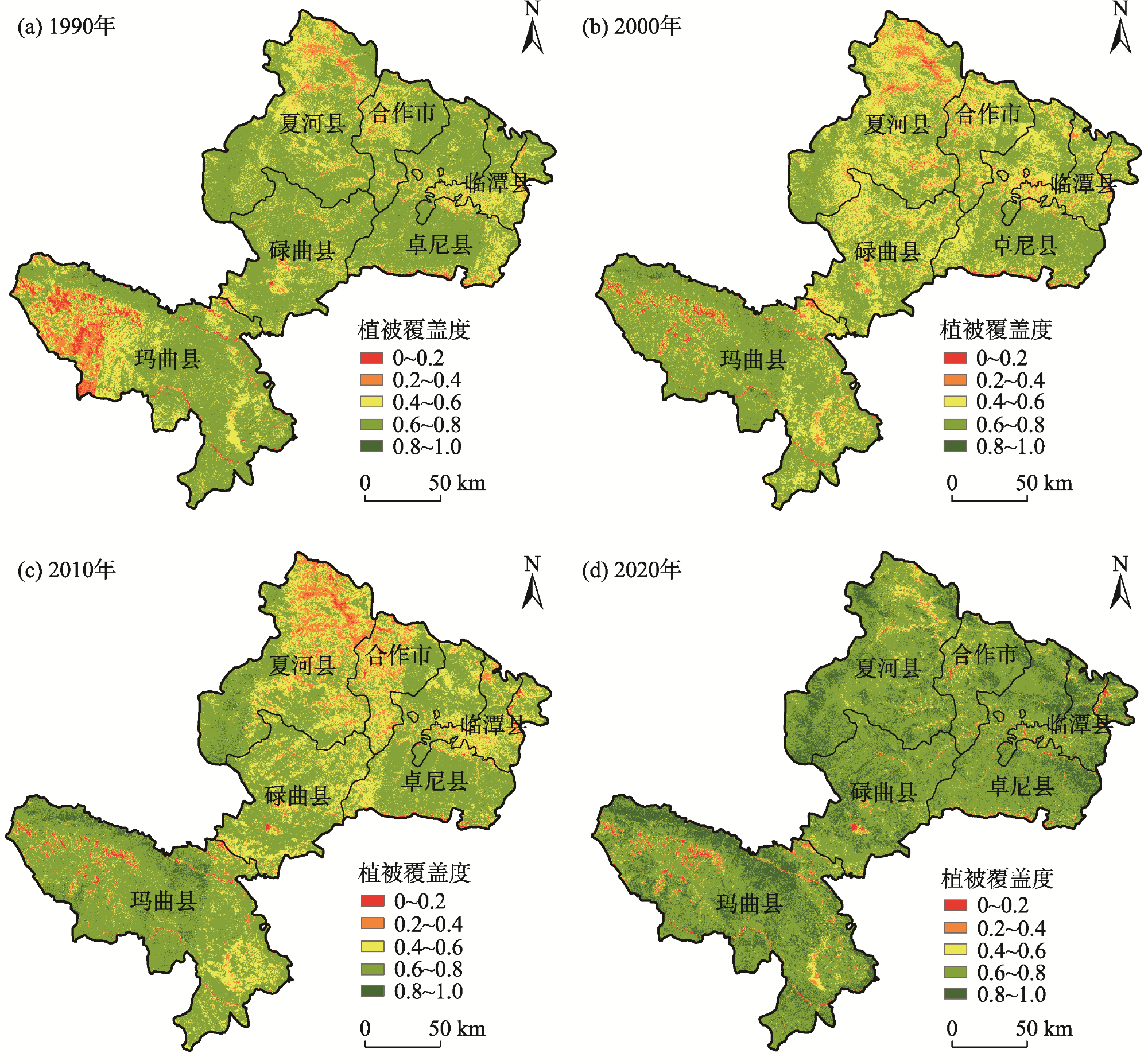
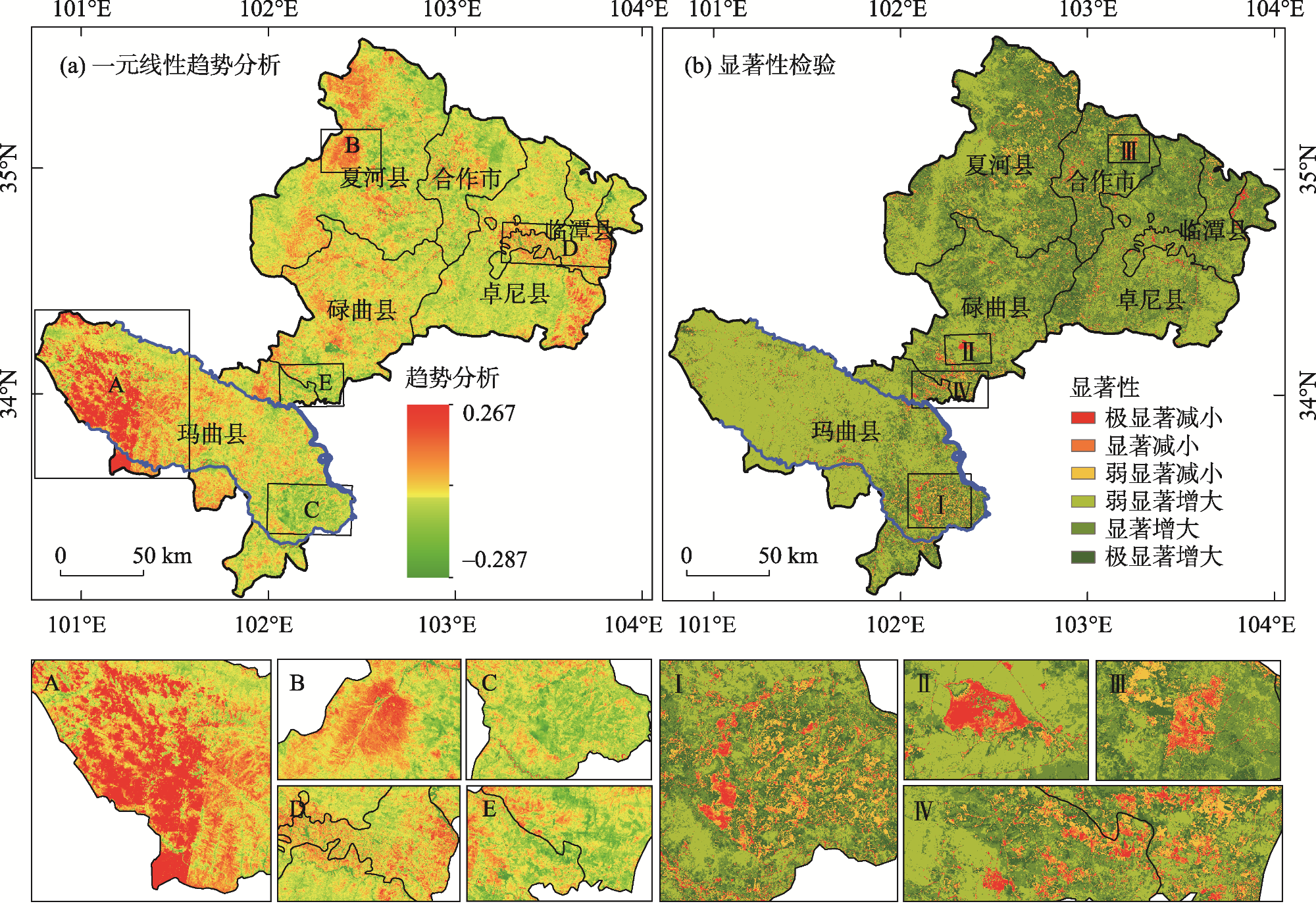
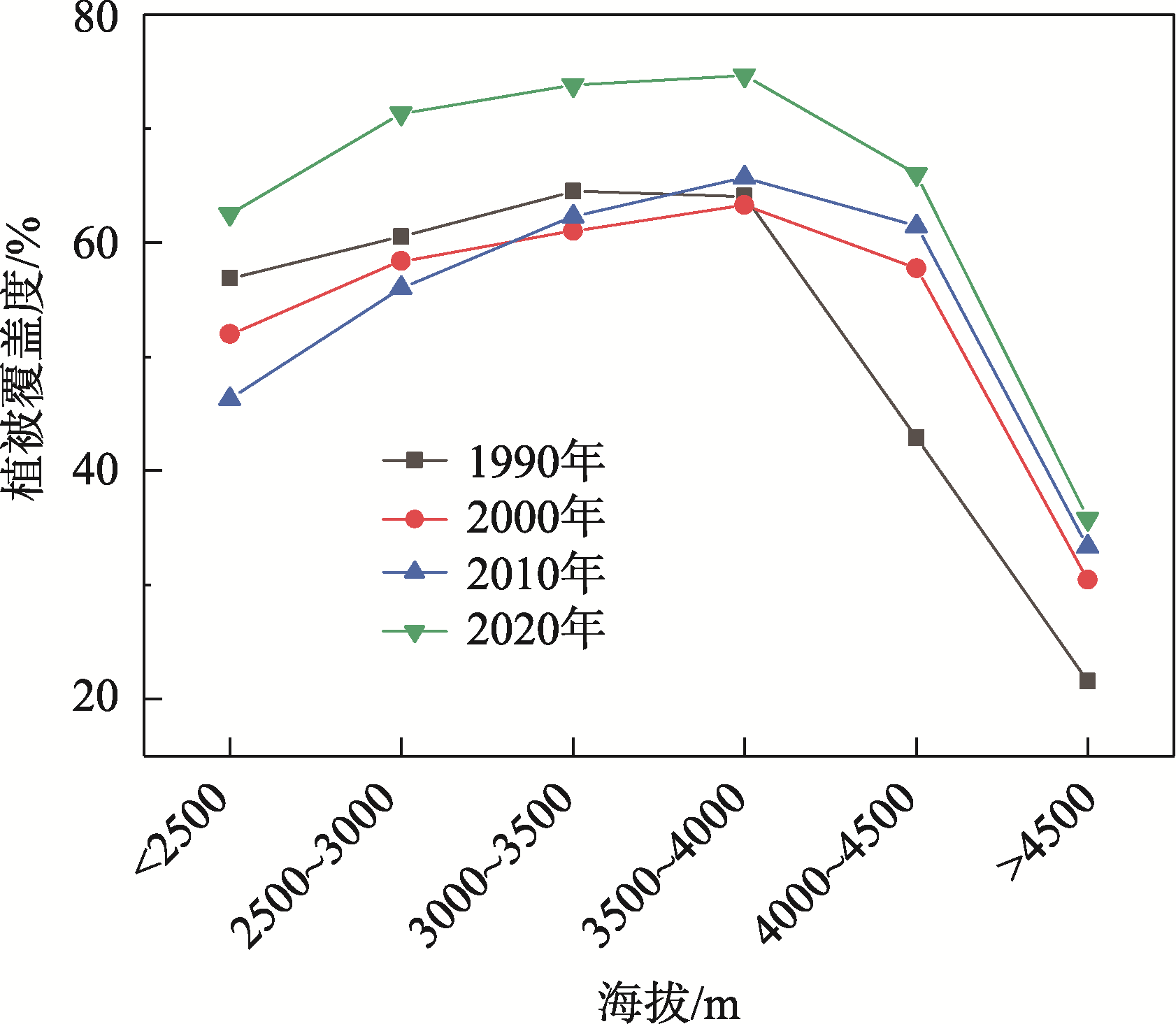
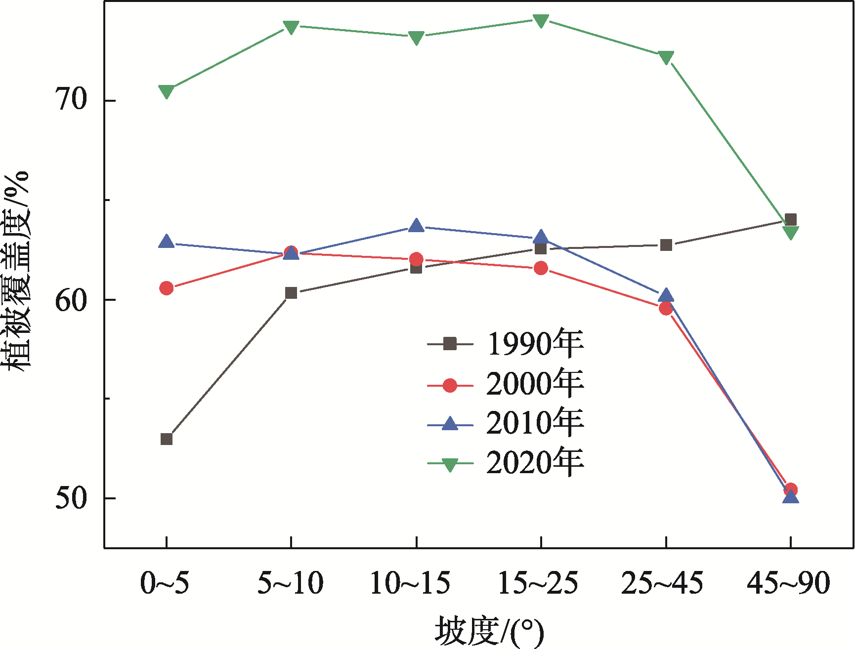
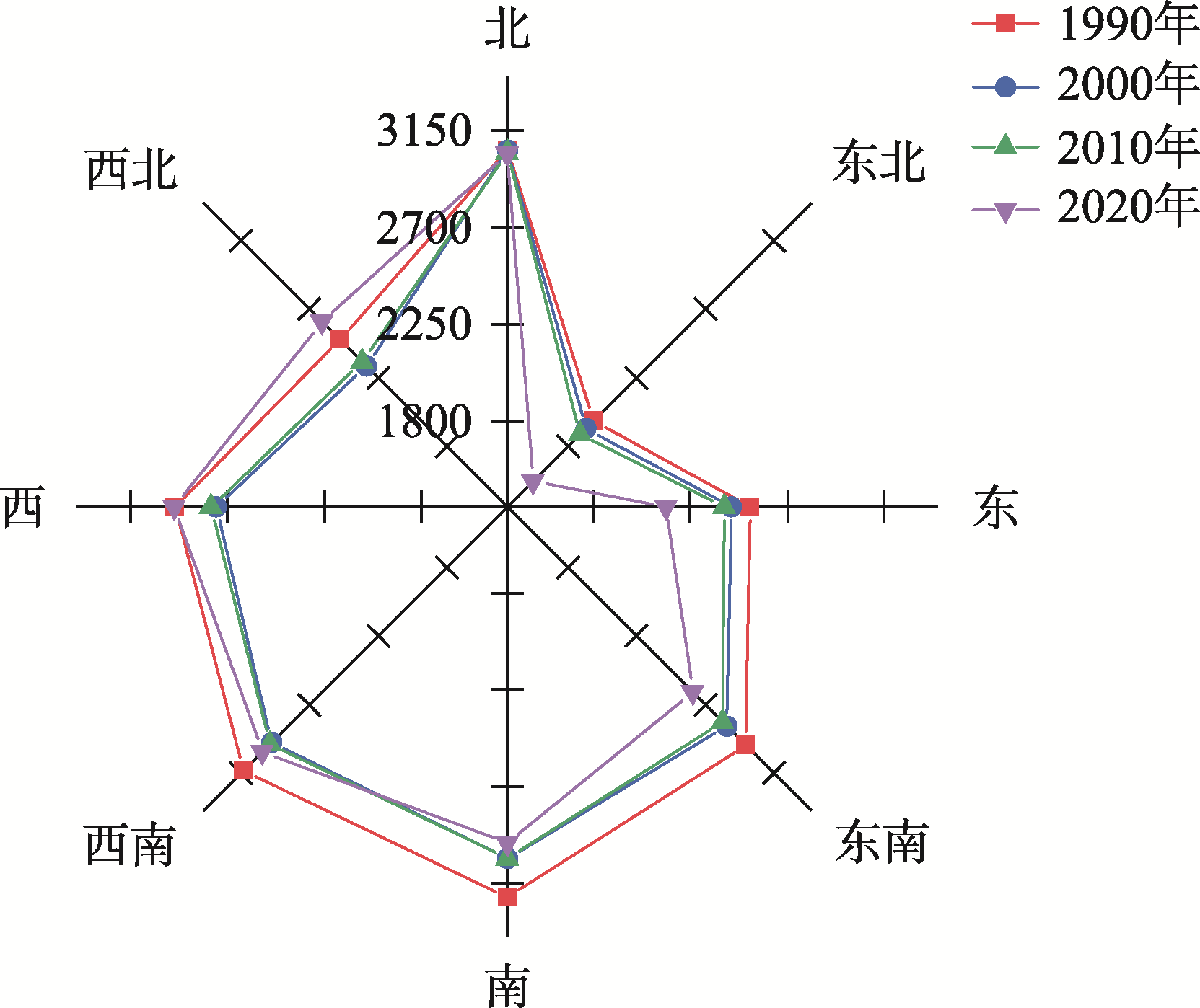
Vegetation cover in the Upper Yellow River in Gannan plays an important role in maintaining the structural stability of the alpine ecosystem and conserving water sources. Exploring the spatiotemporal variation of vegetation cover and its relationship with topographic factors and characterizing the spatiotemporal distribution of vegetation can deepen our understanding of the dynamics and functions of the alpine vegetation ecosystem and provide theoretical support for maintaining ecological balance and restoring vegetation. This paper is based on four periods of Landsat images and Digital Elevation Model data for 1990-2020 at the Upper Yellow River in Gannan, used a pixel dichotomous model, superposition analysis, geographic detector, intensively study the spatiotemporal changes of vegetation coverage and the correlation of topographic features in the study area. The results showed the following: (1) From 1990 to 2020, the vegetation coverage in the Upper Yellow River in Gannan experienced a transition from degradation to recovery and then to significant improvement. The area with medium and high vegetation coverage (0.6-0.8) constituted the largest proportion, accounting for 77.68% of the total study area. (2) Between 1990 and 2020, the vegetation coverage in the study area showed a significant improvement trend. Among them, the area where vegetation coverage improved (Slope>0) accounted for approximately 91.26% of the total area, which was much larger than the area where it declined (Slope<0). (3) There were significant differences in the explanatory power of the topographic factors for vegetation coverage. Elevation is the main driving factor for vegetation coverage, and the explanatory power of the interaction of topographic factors such as slope, slope direction, and elevation is greater than that of a single factor. (4) Vegetation cover in the study area showed a single-peak pattern of increasing and then decreasing with both elevation and slope; the highest vegetation cover was found on southerly slopes, while the lowest was on northeasterly slopes. In the time series, the area of vegetation coverage from the north to the southwest shows a shrinking trend, while the areas in the southwest, west and northwest directions are increasing. The results of this study can provide scientific support for ecological protection and high-quality development in the Upper Yellow River in Gannan.
表1 植被覆盖度划分Tab. 1 Vegetation coverage division |
| 类型 | 低植被覆盖区 | 中低植被覆盖区 | 中植被覆盖区 | 中高植被覆盖区 | 高植被覆盖区 |
|---|---|---|---|---|---|
| 划分等级 | 0~0.2 | 0.2~0.4 | 0.4~0.6 | 0.6~0.8 | 0.8~1 |
表2 1990—2020年甘南黄河上游FVC地形因子探测结果Tab. 2 Results of FVC topographic factor detection in the Upper Yellow River in Gannan from 1990 to 2020 |
| 地形因子 | 解释力p | q |
|---|---|---|
| 海拔 | 0.088 | 0.000 |
| 坡度 | 0.014 | 0.033 |
| 坡向 | 0.010 | 0.058 |
表3 1990—2020年甘南黄河上游FVC地形因子交互作用探测结果Tab. 3 FVC topographic factor interaction detection results in the Upper Yellow River in Gannan from 1990 to 2020 |
| 地形因子 | 海拔 | 坡度 | 坡向 |
|---|---|---|---|
| 海拔 | 0.088 | - | - |
| 坡向 | 0.143 | 0.014 | - |
| 坡度 | 0.128 | 0.032 | 0.010 |
| [1] |
寇杰锋, 杨超, 张莹莹, 等. 黄河中下游伊洛河流域2002—2021年植被覆盖度时空变化及影响因素分析门[J]. 灌溉排水学报, 2024, 43(1): 89-96.
[
|
| [2] |
|
| [3] |
|
| [4] |
|
| [5] |
|
| [6] |
|
| [7] |
|
| [8] |
|
| [9] |
|
| [10] |
|
| [11] |
|
| [12] |
|
| [13] |
王文浩. 甘南玛曲“黄河之肾”面临的生态问题与防治对策[J]. 中国水土保持, 2009, 30(9): 33-35.
[
|
| [14] |
|
| [15] |
|
| [16] |
|
| [17] |
孙雷刚, 郑振华. 基于RS的近30年滹沱河流域植被覆盖度动态变化研究[J]. 地理与地理信息科学, 2014, 30(6): 36-40.
[
|
| [18] |
祝聪, 彭文甫, 张丽芳, 等. 2006—2016年岷江上游植被覆盖度时空变化及驱动力[J]. 生态学报, 2019, 39(5): 1583-1594.
[
|
| [19] |
彭博. 植被覆盖度时空变化特征与地形因子关系分析[J]. 水土保持应用技术, 2023, 43(4): 16-18.
[
|
| [20] |
白洪伟, 徐洋洋. 基于ENVI和ArcGIS的合肥市土地利用/覆被变化分析[J]. 沈阳大学学报(自然科学版), 2016, 28(5): 365-372.
[
|
| [21] |
裴志林, 曹晓娟, 王冬, 等. 内蒙古植被覆盖时空变化特征及其对人类活动的响应[J]. 干旱区研究, 2024, 41(4): 629-638.
[
|
| [22] |
王劲峰, 徐成东. 地理探测器: 原理与展望[J]. 地理学报, 2017, 72(1): 116-134.
[
|
| [23] |
文妙霞, 何学高, 刘欢, 等. 基于地理探测器的宁夏草地植被覆被时空分异及驱动因子[J]. 干旱区研究, 2023, 40(8): 1322-1332.
[
|
| [24] |
银朵朵, 王艳慧. 温带大陆性半干旱季风气候区植被覆盖度时空变化及其地形分异研究[J]. 生态学报, 2021, 41(3): 1158-1167.
[
|
| [25] |
|
| [26] |
林妍敏, 李文慧, 南雄雄, 等. 基于地理探测器的宁夏贺兰山植被覆盖度时空分异及驱动因子[J]. 应用生态学报, 2022, 33(12): 3321-3327.
[
|
| [27] |
|
| [28] |
|
| [29] |
|
| [30] |
杨灿, 魏天兴, 李亦然, 等. 黄土高原典型县域植被覆盖度时空变化及地形分异特征[J]. 生态学杂志, 2021, 40(6): 1830-1838.
[
|
| [31] |
陈浩. 黄土高原退耕还林前后流域土壤侵蚀时空变化及驱动因素研究[D]. 杨凌: 西北农林科技大学, 2019: 160.
[
|
| [32] |
张江蕾, 陈少辉. 祁连山自然保护区植被覆盖时空变化及地形分异研究[J]. 西部林业科学, 2023, 52(1): 106-112.
[
|
| [33] |
付建新, 曹广超, 郭文焖. 1998—2017年祁连山南坡不同海拔、坡度和坡向生长季NDVI变化及其与气象因子的关系[J]. 应用生态学报, 2020, 31(4): 1203-1212.
[
|
| [34] |
袁杰, 曹广超, 杨登兴, 等. 祁连山黑河源区植被NDVI时空变化特征及影响因素分析[J]. 生态科学, 2021, 40(5): 172-182.
[
|
| [35] |
周雪妮, 肖成志, 刘磊, 等. 2000—2020年岷江上游干旱河谷区植被时空变化及其地形效应[J]. 现代地质, 2024, 38(3): 589-598.
[
|
| [36] |
赵昕, 武胜利, 贺清智. 2000—2019年山西省植被覆盖度时空变化特征及地形因素分析[J]. 甘肃农业大学学报, 2024, 59(2): 240-249.
[
|
| [37] |
邓元杰, 姚顺波, 侯孟阳, 等. 长江流域中上游植被NDVI时空变化及其地形分异效应[J]. 长江流域资源与环境, 2020, 29(1): 66-78.
[
|
| [38] |
丁海勇, 丁昕玮. 基于SPOT_NDVI的甘肃省植被覆盖变化及其与气候、地形因子的关系[J]. 长江流域资源与环境, 2020, 29(12): 2665-2678.
[
|
/
| 〈 |
|
〉 |