
中国东北季风边缘区沙地风成沉积剖面光释光定年研究及其古环境意义
|
黄龙(1993-),男,博士,讲师,主要从事光释光年代学与地貌学研究. E-mail: huanglong@lingnan.edu.cn |
收稿日期: 2024-10-11
修回日期: 2025-04-30
网络出版日期: 2025-08-13
基金资助
国家自然科学基金项目(42302212)
萨拉乌苏考古遗址公园管理局校地合作项目(slws20230508)
Optically stimulated luminescence dating of aeolian sediment profiles in the sandy areas of northeastern China near the edge of the monsoon zone and its paleoenvironmental significance
Received date: 2024-10-11
Revised date: 2025-04-30
Online published: 2025-08-13
黄龙 , 古斯乐图 , 周彩婷 , 杨夏瑶 , 司月君 , 黄日辉 , 杭晓菊 , 牛东风 . 中国东北季风边缘区沙地风成沉积剖面光释光定年研究及其古环境意义[J]. 干旱区研究, 2025 , 42(7) : 1323 -1332 . DOI: 10.13866/j.azr.2025.07.15
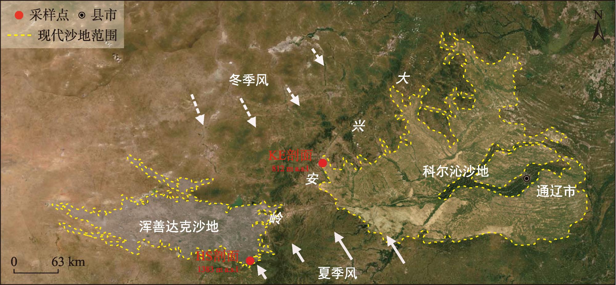
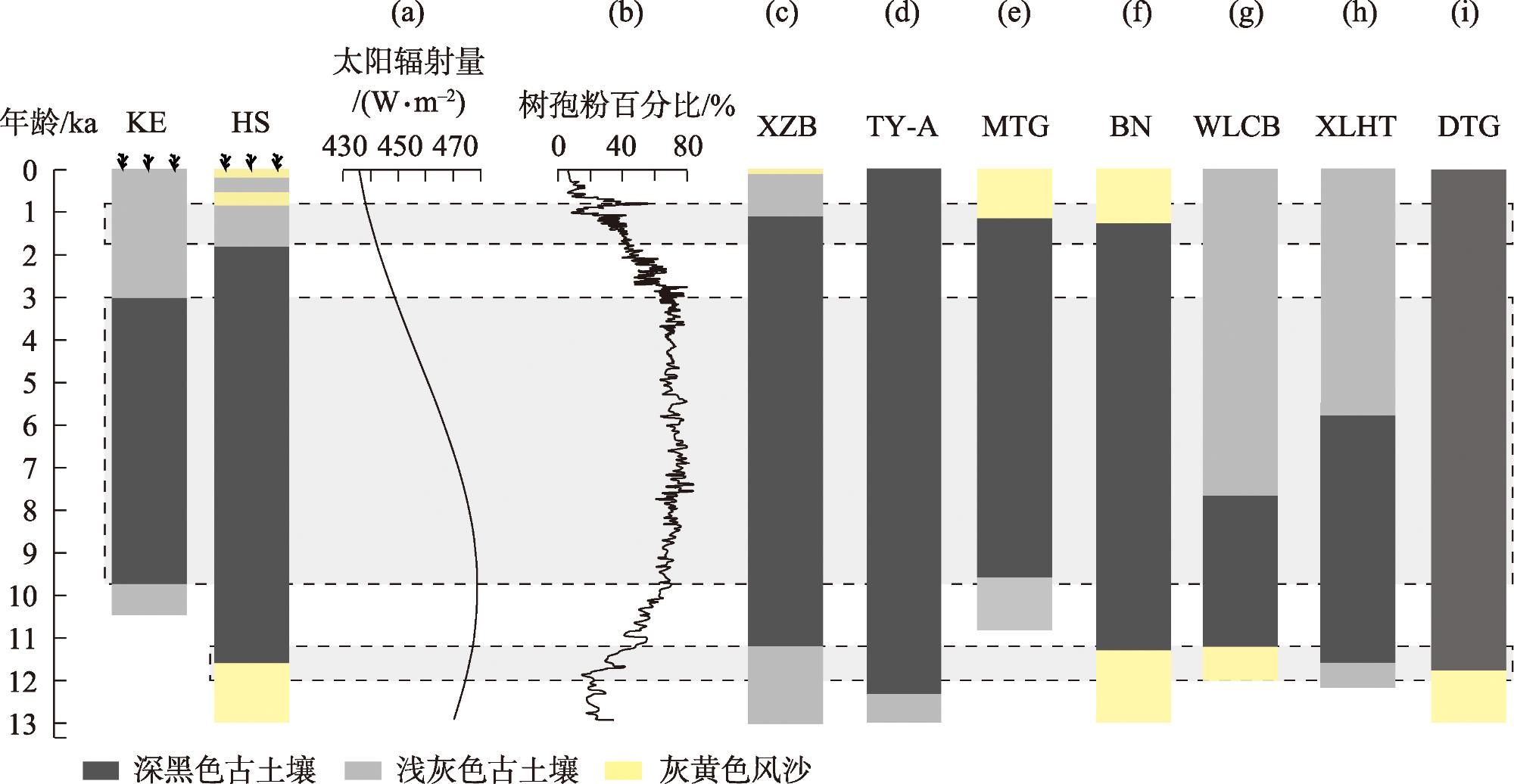
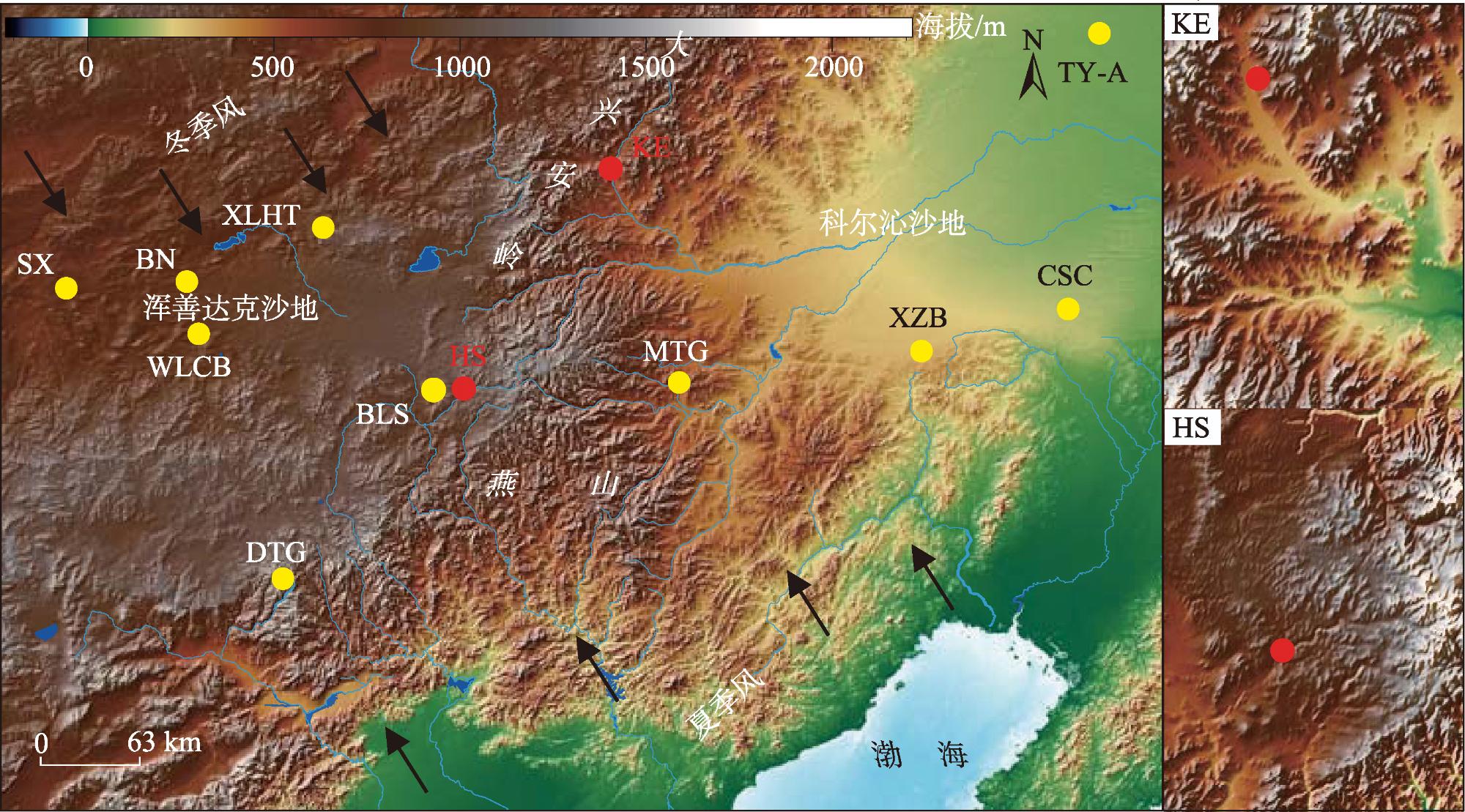
The sandy lands of northeastern China, located near the edge of the East Asian monsoon zone, are highly sensitive to climate change, making them ideal for investigating the evolutionary history of regional aeolian processes. This study presents optically stimulated luminescence dating of aeolian sediments from two representative profiles situated near the edge of the Horqin Sandy Land (KE) and the Otindag Sandy Land (HS). By integrating sedimentary facies data from the two profiles with additional regional paleoenvironmental records, we reconstructed the regional aeolian evolution history and examined the factors influencing sand and paleosol formation. The results revealed that: (1) The KE profile indicated the development of dark black sandy paleosols between about 9.8 and 3.0 ka, likely reflecting weak aeolian activity. In contrast, thick light gray sandy paleosols formed from around 0.2 ka, indicating intensified aeolian activity and continuous reworking of surface sediments, preventing older deposit formation. (2) In the HS profile, gray-yellow aeolian sand layers were deposited around 13.4 ka, 1.2-0.5 ka, and since 0.5 ka, indicating episodes of strong aeolian activity. Dark black sandy paleosols formed between about 11.6 and 1.9 ka, corresponding to a period of weaker aeolian activity. (3) Since about 13.4 ka, the region has undergone three stages of climatic and aeolian evolution: (i) a warming period from 13.4 ka to the early Holocene, associated with relatively strong aeolian activity; (ii) a warm and humid midHolocene, marked by reduced aeolian activity; and (iii) a late Holocene period of fluctuating cooling, during which aeolian activity increased again. (4) Variations in the timing of dark black sandy paleosol development between the KE and HS profiles, compared with records from the central parts of these sandy lands, suggest that regional topography and paleoclimatic differences may significantly influence aeolian sediment development.
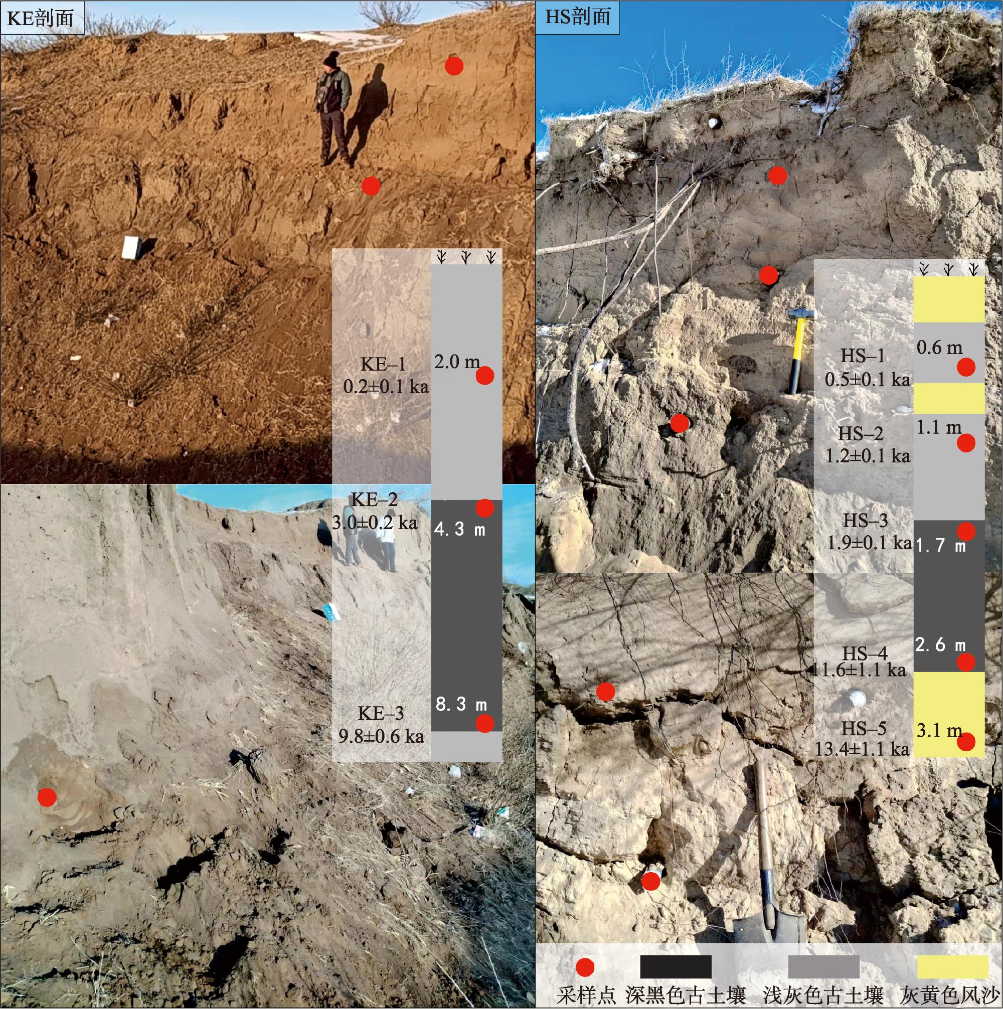
表1 研究剖面沉积物划分、特征描述和采样深度Tab. 1 Deposits division, characterization and sampling depth in the study profile |
| 剖面 | 深度/m | 地层沉积学特征描述 |
|---|---|---|
| KE | 0~4.3 | 浅灰色砂质古土壤,较松散,颗粒较粗,125 μm粒径较多,有植物根系穿插其中,采样KE-1,采样深度为2 m |
| 4.3~8.3 | 深黑色砂质古土壤,较松散,颗粒较细,90 μm粒径较多,于该层顶部和底部分别采样KE-2(4.3 m)和KE-3(8.3 m) | |
| >8.3 | 浅灰色砂质古土壤,较松散,颗粒较粗,未见底 | |
| HS | 0~0.3 | 灰黄色风沙层,有大量植物根系穿插其中,沉积物非常松散,颗粒粗 |
| 0.3~0.7 | 浅灰色砂质古土壤,较松散,颗粒较粗,125 μm粒径较多,采样HS-1(0.6 m) | |
| 0.7~0.9 | 灰黄色风沙层,较松散,颗粒粗 | |
| 0.9~1.6 | 浅灰色砂质古土壤,较松散,颗粒较粗,125 μm粒径较多,采样HS-2(1.1 m) | |
| 1.6~2.6 | 深黑色砂质古土壤,较松散,颗粒较细,90 μm粒径较多,于该层顶部和底部采样HS-3(1.7 m)和HS-4(2.6 m) | |
| >2.6 | 灰黄色风沙层,较松散,颗粒粗,125~150 μm粒径较多,采样HS-5(3.1 m),未见底 |
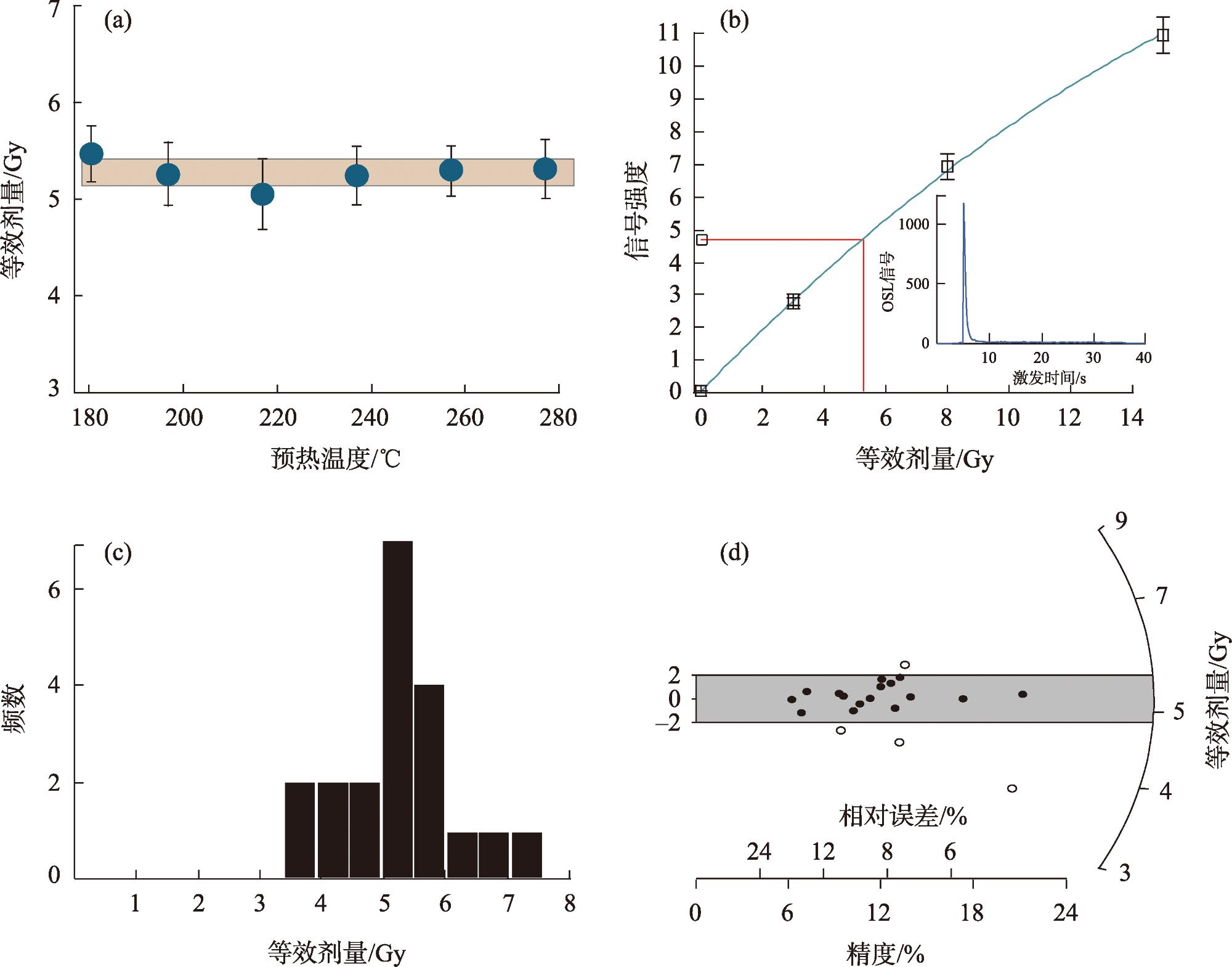
表2 科尔沁沙地和浑善达克沙地剖面样品的光释光定年结果Tab. 2 OSL dating results for two profiles from Horqin Sandy Land and Otindag Sandy Land |
| 样品号 | Th/(μg·g-1)a | U/(μg·g-1)a | K/%a | 含水量/%b | 宇宙射线/(Gy·ka-1)c | 埋藏深度/m | 年剂量率/(Gy·ka-1) | 等效剂量/Gy | 年龄/ka |
|---|---|---|---|---|---|---|---|---|---|
| KE-1 | 4.16 | 0.98 | 2.08 | 5 | 0.18 | 2.0 | 2.64±0.11 | 0.46±0.03 | 0.2±0.1 |
| KE-2 | 4.54 | 1.00 | 1.92 | 5 | 0.14 | 4.3 | 2.47±0.11 | 7.37±0.33 | 3.0±0.2 |
| KE-3 | 4.93 | 1.23 | 2.33 | 5 | 0.09 | 8.3 | 2.89±0.13 | 28.37±1.34 | 9.8±0.6 |
| HS-1 | 2.33 | 0.71 | 2.07 | 5 | 0.24 | 0.6 | 2.51±0.11 | 1.29±0.10 | 0.5±0.1 |
| HS-2 | 2.00 | 0.53 | 2.08 | 5 | 0.23 | 1.1 | 2.44±0.10 | 2.87±0.23 | 1.2±0.1 |
| HS-3 | 3.32 | 0.93 | 2.09 | 5 | 0.21 | 1.7 | 2.61±0.11 | 5.08±0.18 | 1.9±0.1 |
| HS-4 | 2.64 | 0.82 | 2.14 | 5 | 0.19 | 2.6 | 2.56±0.11 | 29.78±2.60 | 11.6±1.1 |
| HS-5 | 1.71 | 0.62 | 2.19 | 5 | 0.18 | 3.1 | 2.49±0.11 | 33.25±2.26 | 13.4±1.1 |
注:a样品U、Th和K含量的相对误差(RSD)估计为5%;b样品含水量的误差估计为±0.05%;c宇宙射线剂量率的误差估计为±0.02 Gy·ka-1。 |
| [1] |
|
| [2] |
夏玉梅. 科尔沁沙地南缘虻石沟黄土地层孢粉分析与古环境的探讨[J]. 中国沙漠, 1989, 9(4): 22-29.
[
|
| [3] |
董光荣, 金炯, 高尚玉, 等. 晚更新世以来我国北方沙漠地区的气候变化[J]. 第四纪研究, 1990, 10(3): 213-222.
[
|
| [4] |
裘善文. 试论科尔沁沙地的形成与演变[J]. 地理科学, 1989, 9(4): 317-328, 97.
[
|
| [5] |
李森, 孙武, 李孝泽, 等. 浑善达克沙地全新世沉积特征与环境演变[J]. 中国沙漠, 1995, 15(4): 323-331.
[
|
| [6] |
李明启, 靳鹤龄, 张洪, 等. 浑善达克沙地磁化率和有机质揭示的全新世气候变化[J]. 沉积学报, 2005, 23(4): 683-689.
[
|
| [7] |
鹿化煜, 弋双文, 徐志伟, 等. 末次盛冰期和全新世大暖期中国沙漠沙地的空间格局[J]. 科学通报, 2013, 58(23): 2775-2783.
[
|
| [8] |
周亚利, 鹿化煜, 张家富, 等. 高精度光释光测年揭示的晚第四纪毛乌素和浑善达克沙地沙丘的固定与活化过程[J]. 中国沙漠, 2005, 25(3): 342-350.
[
|
| [9] |
弋双文, 鹿化煜, 周亚利, 等. 晚第四纪科尔沁沙地干湿变化的黄土记录[J]. 中国沙漠, 2006, 26(6): 869-874.
[
|
| [10] |
赵爽, 夏敦胜, 靳鹤龄, 等. 科尔沁沙地过去近5000年高分辨率气候演变[J]. 第四纪研究, 2013, 33(2): 283-292.
[
|
| [11] |
刘冰, 靳鹤龄, 孙忠. 近6 ka以来科尔沁沙地东部气候变化记录[J]. 中国沙漠, 2011, 31(6): 1398-1405.
[
|
| [12] |
薛文萍, 靳鹤龄, 刘冰, 等. 中国季风边缘区全新世沙地演化及其驱动机制研究进展[J]. 中国沙漠, 2019, 39(3): 163-171.
[
|
| [13] |
|
| [14] |
|
| [15] |
周亚利, 鹿化煜,
[
|
| [16] |
|
| [17] |
韩鹏, 孙继敏. 浑善达克沙地的光释光测年研究[J]. 第四纪研究, 2004, 24(4): 480.
[
|
| [18] |
杨小平, 梁鹏, 方伊曼, 等. 中国沙漠与环境演变[M]. 北京: 科学出版社, 2024.
[
|
| [19] |
李思慧. 1961—2018年科尔沁沙地气候变化特征[J]. 内蒙古气象, 2019(5): 8-10.
[
|
| [20] |
杨晓刚, 宝音, 张静, 等. 克什克腾旗加强草原生态保护与修复促进草原资源可持续发展[J]. 内蒙古林业, 2022(7): 9-11.
[
|
| [21] |
|
| [22] |
|
| [23] |
|
| [24] |
|
| [25] |
|
| [26] |
|
| [27] |
徐志伟, 鹿化煜. 毛乌素沙地风沙环境变化研究的理论和新认识[J]. 地理学报, 2021, 76(9): 2203-2223.
[
|
| [28] |
|
| [29] |
|
| [30] |
弋双文, 鹿化煜, 曾琳, 等. 末次盛冰期以来科尔沁沙地古气候变化及其边界重建[J]. 第四纪研究, 2013, 33(2): 206-217.
[
|
| [31] |
杨萍. 中国东部沙区全新世砂质古土壤与古气候变化[D]. 金华: 浙江师范大学, 2014.
[
|
| [32] |
田娅琪, 周亚利, 孙晓巍, 等. 末次盛冰期以来浑善达克沙地光释光年代学及气候变化研究[J/OL]. 沉积学报, 1-20 [2024-07-15].
[
|
| [33] |
杨小平, 梁鹏, 张德国, 等. 中国东部沙漠/沙地全新世地层序列及其古环境[J]. 中国科学: 地球科学, 2019, 49(8): 1293-1307.
[
|
| [34] |
杨利荣, 岳乐平. 浑善达克沙地末次冰期晚期到全新世的环境转型[J]. 地球环境学报, 2011, 2(1): 301-306.
[
|
| [35] |
郑琳, 谢东, 于尧, 等. 1961—2018年浑善达克沙地气候变化分析[J]. 现代农业科技, 2024(19): 117-120.
[
|
| [36] |
姚淑珍, 王补生, 杜瑛红, 等. 克什克腾旗自然降水资源分析[J]. 内蒙古农业科技, 2012(3): 108-109.
[
|
| [37] |
周亚利, 鹿化煜, 张小艳, 等. 末次盛冰期和全新世大暖期浑善达克沙地边界的变化[J]. 第四纪研究, 2013, 33(2): 228-242.
[
|
/
| 〈 |
|
〉 |