
干旱区地下水埋深对土壤水盐运移影响的模拟与调控——以阿克苏河下游河岸带典型田块为例
|
鲁力(1995-),男,博士研究生,主要研究方向为水文地质与环境地质. E-mail: luli0401@sina.com |
收稿日期: 2024-08-11
修回日期: 2025-03-28
网络出版日期: 2025-08-13
基金资助
国家自然科学基金项目(U23A2024)
国家地下水监测网运维项目(DD20251302)
Depth on soil water-salt transport in arid regions: A case study of representative farmland in the riparian zone of lower Aksu River
Received date: 2024-08-11
Revised date: 2025-03-28
Online published: 2025-08-13
鲁力 , 郭建华 , 王友年 . 干旱区地下水埋深对土壤水盐运移影响的模拟与调控——以阿克苏河下游河岸带典型田块为例[J]. 干旱区研究, 2025 , 42(7) : 1196 -1210 . DOI: 10.13866/j.azr.2025.07.04
Salinization in the irrigation areas of watersheds in downstream arid regions exacerbates soil degradation, crop yield reduction, and river water salinization, severely limiting agricultural production and harming ecological stability. It arises in a manner influenced by the depth of groundwater and poor irrigation and drainage management. Scientifically formulating measures to regulate soil water-salt is key to addressing these issues. In this study, field experiments were conducted in a typical farmland area of the riparian zone by the downstream part of Aksu River. Based on dynamic observations and field survey data, an unsaturated model was established using the HYDRUS-1D software to simulate soil water and salt transport patterns during the cotton growing season, determine appropriate regulatory strategies, and explore the relationship between the stable groundwater evaporation depth and riparian soil structure. The results revealed that the identification and validation accuracy of the soil moisture content and total dissolved solids were 0.862 and 0.752 with root mean square errors of 0.033 and 0.008, respectively, indicating that the model was highly reliable. Irrigation infiltration accounted for 85% of the total soil water recharge, introducing 127.164 mg·cm-2 of salt, while soil water discharge to groundwater accounted for 59.67% of the total discharge, removing 267.78 mg·cm-2 of salt. The water balance error was 9.2% and the desalination rate was 33.89%. Considering the demand for water for crops and soil salinity dynamics, setting the irrigation water depth to 70 cm while maintaining the groundwater depth at approximately 220 cm can effectively reduce the soil salinity in the root zone. In sandy loam structures, the position of the loam layer has little effect on the critical evaporation depth of groundwater (150 cm), but significantly influences the stable evaporation depth and actual evaporation. If the loam layer is closer to the surface, the stable evaporation depth becomes shallower and the actual evaporation decreases. The findings provide a reference for preventing salinization and managing water resources in arid regions.
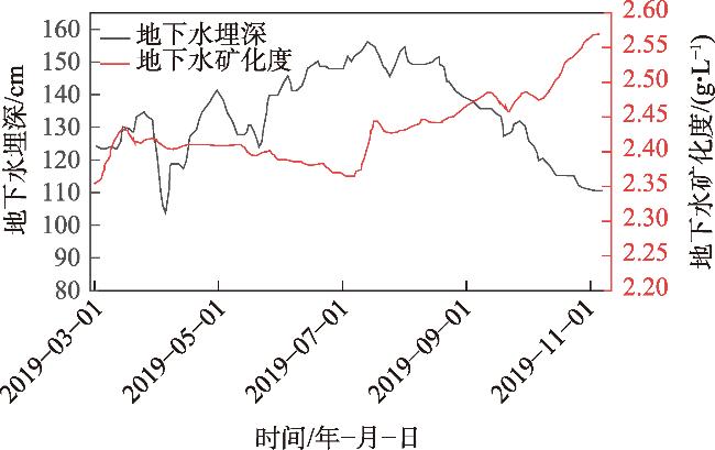
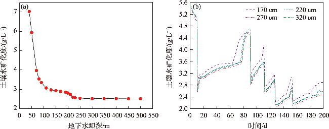
图4 试验区地下水埋深与水质变化Fig. 4 Variation of groundwater depth and water quality in the experimental area |
表1 土壤基本物理特性以及VG参数Tab. 1 Basic physical properties of soil and VG parameter table |
| 深度/m | 土壤物理特性 | VG参数 | |||||||
|---|---|---|---|---|---|---|---|---|---|
| 砂粒/% | 粉粒/% | 黏粒/% | α | n | |||||
| 0~0.35 | 74.65 | 23.63 | 1.72 | 90.62 | 0.029 | 0.398 | 0.047 | 1.549 | |
| 0.35~0.8 | 65.82 | 30.26 | 3.92 | 66.11 | 0.03 | 0.396 | 0.035 | 1.422 | |
| 0.8~1.8 | 88.58 | 10.96 | 0.46 | 304.76 | 0.039 | 0.389 | 0.044 | 2.542 | |
注:表中土壤颗粒分级按照国际制; 为饱和导水率(cm·d-1); 为土壤残余含水率(cm3·cm-3); 为饱和含水率(cm3·cm-3);α、n为经验参数。 |
图7 不同土壤深度含水率、TDS的模拟精度比较Fig. 7 Comparison of simulation accuracy of moisture content and TDS at different soil depths |
表2 不同土壤深度含水率、TDS的模拟精度检验Tab. 2 Table for accuracy verification of simulated soil moisture content and TDS at different soil depths |
| 拟合参数 | 含水率 | 浓度 | |||
|---|---|---|---|---|---|
| 评价指标 | RMSE | NSE | RMSE | NSE | |
| 15 cm | 0.07 | 0.682 | 0.105 | 0.798 | |
| 30 cm | 0.034 | 0.565 | 0.038 | 0.573 | |
| 70 cm | 0.02 | 0.529 | 0.008 | 0.494 | |
| 110 cm | 0.007 | 0.459 | 0.016 | 0.361 | |
| 150 cm | 0.004 | 0.351 | 0.019 | 0.322 | |
| 总体 | 0.033 | 0.862 | 0.008 | 0.752 | |
图8 不同深度土壤含水率、浓度的观测值与模拟值拟合结果Fig. 8 Fitting results of observed and simulated soil moisture content and concentration at different depths |
表3 校正后的土壤水力参数与溶质运移参数Tab. 3 Corrected soil hydraulic parameters and solute transport parameters |
| 深度/m | 土壤类型 | α | n | |||||
|---|---|---|---|---|---|---|---|---|
| 0~0.35 | 粉砂土 | 0.046 | 0.525 | 0.032 | 1.686 | 83.419 | 0.34 | 16.3 |
| 0.35~0.8 | 壤土 | 0.021 | 0.546 | 0.075 | 1.288 | 53.801 | 0.34 | 14.9 |
| 0.8~1.8 | 细砂 | 0.060 | 0.457 | 0.037 | 2.281 | 169.720 | 0.34 | 27.2 |
注: 表示分子扩散系数(cm·d-1); 表示弥散度(cm)。 |
表4 土壤水分数值模拟均衡Tab. 4 Balance of numerical simulation of soil moisture |
| 水分 补给项 | 补给水量/mm | 比值/% | 水分 排泄项 | 排泄水 量/mm | 比值/% |
|---|---|---|---|---|---|
| 灌溉水量+降雨量 | 1269.40 | 85.66 | 作物蒸腾 | 333.05 | 24.75 |
| 潜水补给 | 212.42 | 14.34 | 潜水蒸发 | 209.56 | 15.58 |
| 底边界排泄 | 802.94 | 59.67 | |||
| 合计 | 1481.82 | 100 | 合计 | 1345.55 | 100 |
表5 土壤盐分数值模拟均衡Tab. 5 Soil salinity numerical simulation equilibrium |
| 月份 | 进盐量 | 排盐量 | 补给量 | 积盐量 | 总进盐量 | 总排盐量 | 总积盐量 | 脱盐率/% |
|---|---|---|---|---|---|---|---|---|
| /(mg·cm-2) | ||||||||
| 3 | 31.44 | 44.258 | 35.581 | 22.763 | 199.99 | -267.78 | -67.79 | 33.89 |
| 4 | 31.44 | 52.474 | 3.096 | -17.938 | ||||
| 5 | 31.44 | 95.091 | 1.519 | -62.132 | ||||
| 6 | 0 | 21.83 | 0.69 | -21.14 | ||||
| 7 | 32.844 | 52.38 | 8.56 | -10.976 | ||||
| 8 | 0 | 1.75 | 9.34 | 7.59 | ||||
| 9 | 0 | 0 | 14.04 | 14.04 |
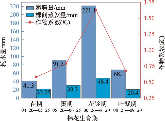
表6 农田棉花灌溉制度优化Tab. 6 Optimization of irrigation system for cotton in farmland |
| 棉花生育期 | 灌溉日期/月-日 | 灌溉量/mm |
|---|---|---|
| 春灌 | 03-10—03-25 | 156.85 |
| 苗期 | 04-20—04-30 | 63.35 |
| 蕾期 | 05-25—05-30 | 121.8 |
| 花期 | 06-25—06-30 | 269.5 |
| 吐絮期 | 08-20—08-25 | 88.5 |
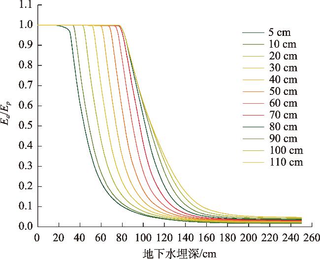
图14 夹壤层位置控制下实际蒸散(Ea)与潜在蒸发量(Ep)在不同地下水位深度下的比值Fig. 14 Variation of actual evaporation and stable evaporation depth with groundwater depth under the control of the soil layer position |
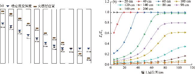
图15 稳定蒸发深度与夹壤层位置的关系(a),不同水位条件下夹壤层位置对实际蒸散(Ea)与潜在蒸发量(Ep)比值的影响(b)Fig. 15 Relationship between stable evaporation depth and the position of the interlayer (a), The influence of interlayer position on the ratio of actual evapotranspiration (Ea) to potential evaporation (Ep) under different water level conditions (b) |
| [1] |
鲁力, 葛燕燕, 李升, 等. 新疆阿克苏河流域高砷地下水化学特征及富集成因[J]. 干旱区研究, 2025, 42(2): 258-273.
[
|
| [2] |
|
| [3] |
|
| [4] |
|
| [5] |
朱会义. 土地利用变化的内在动力——新疆地区农业生产要素产出效率的变动趋势分析[J]. 地理学报, 2013, 68(8): 1029-1037.
[
|
| [6] |
|
| [7] |
|
| [8] |
|
| [9] |
|
| [10] |
|
| [11] |
|
| [12] |
|
| [13] |
|
| [14] |
|
| [15] |
|
| [16] |
|
| [17] |
|
| [18] |
|
| [19] |
|
| [20] |
|
| [21] |
中国科学院新疆生物土壤沙漠研究所. 新疆土壤及土地资源研究[M]. 北京: 科学出版社, 1991: 1-37.
[ Xinjiang Institute of Ecology and Geography, Chinese Academy of Sciences. Research on Xinjiang Soil and Land Resources[M]. Beijing: Science Press, 1991: 1-37.]
|
| [22] |
新疆农业农村厅, 新疆土壤普查办公室. 新疆土壤[M]. 北京: 科学出版社, 1996: 151-521.
[ Xinjiang Agricultural Department, Xinjiang Soil Survey Office. Xinjiang Soil[M]. Beijing: Science Press, 1996: 151-521.]
|
| [23] |
|
| [24] |
|
| [25] |
|
| [26] |
张立桢, 曹卫星, 张思平, 等. 棉花根系生长和空间分布特征[J]. 植物生态学报, 2005, 29(2): 266-273.
[
|
| [27] |
胡宏昌, 张治, 田富强, 等. 新疆绿洲棉田盐分及作物生长对灌溉方式的响应[J]. 清华大学学报: 自然科学版, 2016, 56(4): 373-380.
[
|
| [28] |
|
| [29] |
|
| [30] |
|
| [31] |
|
| [32] |
刘洪光, 白振涛, 李开明. 基于HYDRUS-2D模型的膜下滴灌暗管排水棉田土壤盐分变化[J]. 农业工程学报, 2021, 37(2): 130-141.
[
|
| [33] |
|
| [34] |
王璐. 阿克苏河流域盐渍化区包气带水盐运移规律及潜水位动态调控研究[D]. 乌鲁木齐: 新疆大学, 2020.
[
|
| [35] |
DB65/T 4565-2022. 机采棉主要农艺性状指标要求[S]. 乌鲁木齐: 新疆维吾尔自治区市场监督管理局, 2022.
[ DB65/T 4565-2022. Requirements for Main Agronomic Traits of Machine-Picked Cotton[S]. Urumqi: Xinjiang Uygur Autonomous Region Market Supervision Administration, 2022.]
|
| [36] |
鲁力, 李升, 高远, 等. 渭-库绿洲土壤盐分空间分布及变异特征[J]. 干旱区资源与环境, 2022, 36(3): 136-142.
[
|
| [37] |
|
| [38] |
李强, 刘天超, 李通, 等. 新疆阿克苏河流域水文地质环境地质调查报告[R]. 乌鲁木齐: 新疆方圆地质矿产勘查院(有限公司), 2019.
[
|
| [39] |
李艳, 胡顺军, 宋郁东. 渭干河灌区潜水蒸发规律实验分析[J]. 干旱区资源与环境, 2004, 18(3): 92-96.
[
|
| [40] |
来剑斌, 王永平, 蒋庆华, 等. 土壤质地对潜水蒸发的影响[J]. 西北农林科技大学学报(自然科学版), 2003, 31(6): 153-157.
[
|
| [41] |
|
| [42] |
|
/
| 〈 |
|
〉 |