
干旱区自然资源地表基质细化分类体系构建与调查深度
|
李双媛(2000-),女,硕士研究生,研究方向为景观尺度土地资源. E-mail: lsy000615@126.com |
收稿日期: 2024-08-09
修回日期: 2024-11-09
网络出版日期: 2025-08-13
基金资助
自然资源要素耦合过程与效应重点实验室开放课题(2022KFKTC016)
“天山英才”培养计划(2023TSYCLJ0048)
Construction of a refined classification system and survey depth of underground for natural resource ground substrates in arid zones
Received date: 2024-08-09
Revised date: 2024-11-09
Online published: 2025-08-13
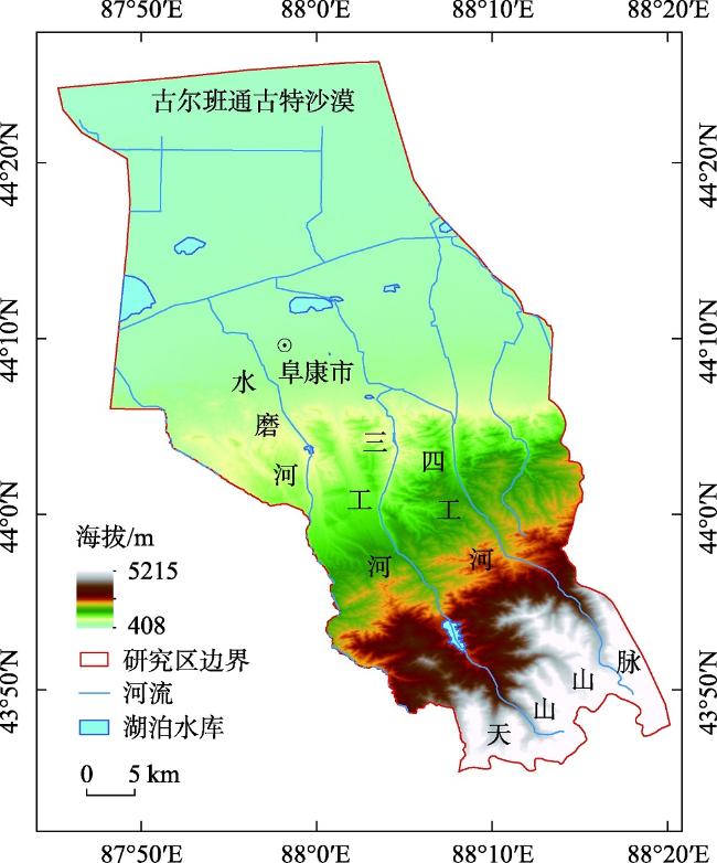
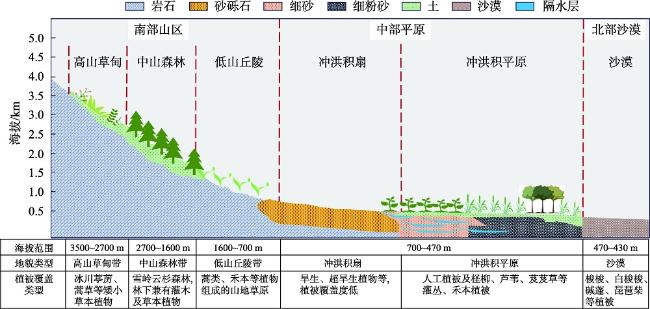
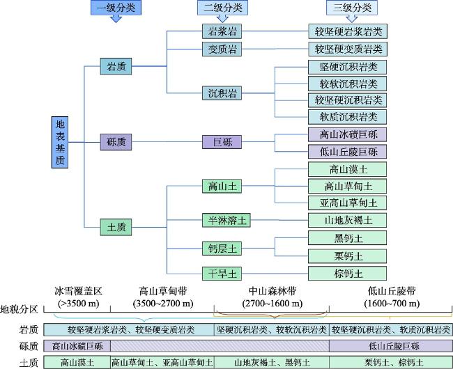
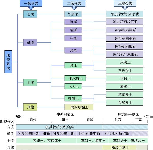
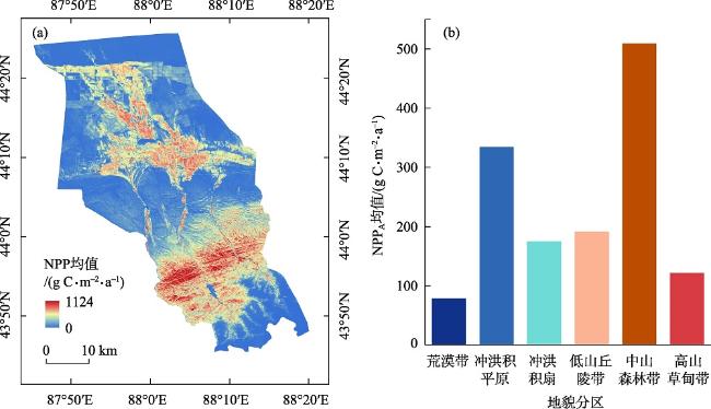
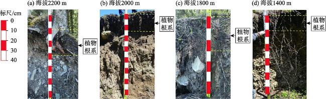
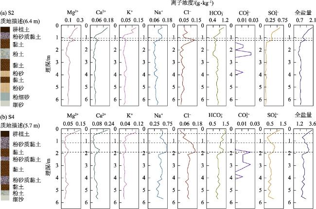
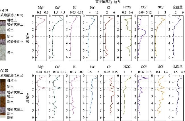
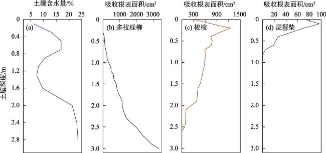
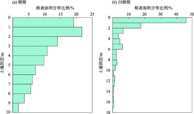
地表基质分类是开展地表基质调查监测的基础,同时也是揭示地表基质与地表覆盖层的协同耦合关系的关键,有助于从地表覆被和地下空间要素两个层次认识地表基质与生态环境的作用机制。本研究以干旱区典型的内陆河流域——新疆三工河流域为靶区,依据干旱区山地-绿洲-荒漠景观异质性分布特征,在地表基质的分布区域、海拔范围及主要地表覆被的基础上,构建了一套地表基质三级分类分区体系。整体划分为4个地表基质一级类、17个二级类及28个三级类。根据土壤理化性质及植被根系分布特征,地表基质调查深度在南部山区以50 cm;中部平原区以3 m;北部沙漠区小于10 m为宜。此外,基于垂直带生态系统NPP的分异性特征,验证了分类体系的合理性,体现了地表基质层孕育支撑土地覆被的作用关系。研究成果为未来干旱区自然资源调查监测和科学管理决策提供理论与技术支撑。
李双媛 , 徐柱 , 王玉刚 , 孙金金 . 干旱区自然资源地表基质细化分类体系构建与调查深度[J]. 干旱区研究, 2025 , 42(1) : 84 -96 . DOI: 10.13866/j.azr.2025.01.08
The classification of the ground substrate is a fundamental basis for conducting ground substrate surveys and monitoring. It reveals the synergistic coupling relationship between the ground substrate and the surface cover layer, which aids in understanding the mechanisms of interaction between the ground substrate and the ecological environment from both the surface cover and subsurface spatial elements. This study targeted the Sangong River Basin in Xinjiang, a typical inland river basin in an arid region. Based on the heterogenous distribution of the mountain-oasis-desert landscape in arid regions, a three-tier classification and zoning system for ground substrates was developed, considering the distribution area, elevation range, and main surface cover of the surface substrates. The overall classification was divided into four primary categories, 17 secondary categories, and 28 tertiary categories. Considering the physical and chemical properties of the soil and the distribution characteristics of vegetation root systems, the suitable survey depth for ground substrates in the southern mountainous area was 50 cm; in the central plain area, it was 3 m; and in the northern desert area, it was less than 10 m. Additionally, based on the differentiation characteristics of Net Primary Productivity in vertical zonal ecosystems, the rationality of the classification system was validated, reflecting the role of ground substrate layers in nurturing and supporting land cover. These results provide theoretical and technical support for future natural resource surveys, monitoring, and scientific management decisions in arid regions.
表1 采样点土地利用类型及特征Tab. 1 Landuse and characteristics of sampling sites |
| 编号 | 土地利用类型 | 灌溉方式 | 灌溉水源 | 采样数量 | 水位埋深/m |
|---|---|---|---|---|---|
| S1 | 荒漠 | - | - | 29 | 5.8 |
| S2 | 农田 | 滴灌 | 地下水 | 32 | 6.4 |
| S3 | 荒漠 | - | - | 28 | 5.6 |
| S4 | 农田 | 滴灌 | 地下水 | 29 | 5.7 |
表2 数据及来源Tab. 2 Data and sources |
| 数据类型 | 数据名称 | 数据精度 | 数据格式 | 简介及来源 |
|---|---|---|---|---|
| 气象数据 | 温度、降水数据 | 1 km | TIFF | 采用1901—2022年中国1 km分辨率逐月平均气温和降水量数据集(http://www.geodata.cn),时间序列为1990—2020年 |
| 太阳辐射数据 | 1 km | TIFF | 太阳总辐射数据通过日照百分率数据换算得到。本文使用的日照百分率数据来源于国家气象科学数据共享服务平台(http://data.cma.cn),时间序列为1990—2020年。通过和清华等[14]的方法计算太阳总辐射值 | |
| 遥感数据 | DEM数据 | 30 m | TIFF | 采用ASTER GDEM产品,来自地理空间数据云(https://www.gscloud.cn) |
| NDVI数据 | 30 m | TIFF | 采用Landsat影像数据,来自谷歌地球引擎(Google Earth Engine,GEE)平台时间序列为1990—2020年。影像的调取和处理基于GEE云平台,其中1990—2011年和2013—2020年的影像分别选用Landsat 5和Landsat 8数据。经去云、大气校正和裁剪等前处理,通过计算公式[15]进行NDVI的计算 | |
| 植被覆盖 类型数据 | 500 m | TIFF | 采用MODIS MCD12Q1(https://search.earthdata.nasa.gov/search)的年度合成产品,时间序列为2001—2019年 |
表3 北部沙漠区地表基质分类方案Tab. 3 Classification of ground substrates in the Northern Desert Area |
| 一级分类 | 二级分类 | 分类定义 | 三级分类 | 主要分布区域及海拔范围 | 主要植被类型 |
|---|---|---|---|---|---|
| 土质 | 初育土 | 土壤发育程度微弱,保持相对的幼年阶段,土壤剖面层次分异不明显 | 风沙土 | 分布于北部沙漠区,海拔约430~470 m | 梭梭、白梭梭、琵琶柴、碱蓬等植被 |
| [1] |
自然资源部. 自然资源部办公厅关于印发《地表基质分类方案(试行)》的通知[EB/OL]. 2020, http://gi.mnr.gov.cn/202012/t20201222_2596025.html.
[ Ministry of Natural Resources. Notice of the General Office of the Ministry of Natural Resources Printing and Distributing the Ground Cover Layer Classification Scheme (Trial)[EB/OL]. 2020, http://gi.mnr.gov.cn/202012/t20201222_2596025.html. ]
|
| [2] |
侯红星, 张蜀冀, 鲁敏, 等. 自然资源地表基质层调查技术方法新经验——以保定地区地表基质层调查为例[J]. 西北地质, 2021, 54(3): 277-288.
[
|
| [3] |
殷志强, 陈自然, 李霞, 等. 地表基质综合调查:内涵、分层、填图与支撑目标[J]. 水文地质工程地质, 2023, 50(1): 144-151.
[
|
| [4] |
孙禧勇, 许玮, 王明建. 地表基质层分层分类调查研究[J]. 中国土地, 2022(7): 34-36.
[
|
| [5] |
朱永官, 李刚, 张甘霖, 等. 土壤安全: 从地球关键带到生态系统服务[J]. 地理学报, 2015, 70(12): 1859-1869.
[
|
| [6] |
殷志强, 秦小光, 张蜀冀, 等. 地表基质分类及调查初步研究[J]. 水文地质工程地质, 2020, 47(6): 8-14.
[
|
| [7] |
葛良胜, 侯红星, 夏锐. 自然资源地表基质调查技术体系构建[J]. 地理信息世界, 2022, 29(5): 20-27.
[
|
| [8] |
艾晓军, 陈占生, 耿国帅, 等. 辽阳—丹东地区黑土地地表基质有效土层分布规律及影响因素——以凤城市为例[J]. 河北农业科学, 2023, 27(3): 54-59, 65.
[
|
| [9] |
霍东, 陈占生, 艾晓军, 等. 遥感解译在辽阳-丹东地区黑土地地表基质调查中的应用——以宽甸满族自治县为例[J]. 农业与技术, 2023, 43(15): 115-119.
[
|
| [10] |
刘洪博, 孔繁鹏, 赵建, 等. 地表基质调查技术方法探索与实验——以黑龙江省宝清县黑土地调查为例[J]. 地理信息世界, 2022, 29(6): 1-5.
[
|
| [11] |
孙勇刚, 张闯, 尚晓雨, 等. 不同地表基质类型理化性质探索与研究——以河北塞罕坝示范区为例[J]. 资源信息与工程, 2023, 38(2): 13-16.
[
|
| [12] |
王根绪, 程国栋. 干旱荒漠绿洲景观空间格局及其受水资源条件的影响分析[J]. 生态学报, 2000, 20(3): 363-368.
[
|
| [13] |
鲁如坤. 土壤农业化学分析方法[M]. 北京: 中国农业科技出版社, 2000.
[
|
| [14] |
和清华, 谢云. 我国太阳总辐射气候学计算方法研究[J]. 自然资源学报, 2010, 25(2): 308-319.
[
|
| [15] |
栾海军, 邢宸硕, 张荣凯, 等. 基于Chen NDVI模型的NDVI尺度转换分形特性分析[J]. 遥感信息, 2022, 37(3): 12-20.
[
|
| [16] |
朱文泉, 陈云浩, 徐丹, 等. 陆地植被净初级生产力计算模型研究进展[J]. 生态学杂志, 2005, 24(3): 296-300.
[
|
| [17] |
朱文泉, 潘耀忠, 龙中华, 等. 基于GIS和RS的区域陆地植被NPP估算——以中国内蒙古为例[J]. 遥感学报, 2005, 9(3): 300-307.
[
|
| [18] |
|
| [19] |
|
| [20] |
尹小君, 祝宏辉,
[
|
| [21] |
陈炳铭, 赵善超, 孙丰华, 等. 气候变化和人类活动对干旱区垂直自然带NPP的影响[J]. 生态学杂志, 2023, 42(6): 1474-1483.
[
|
| [22] |
郝鑫怡, 张喆, 郑浩, 等. 天山北坡经济带植被覆盖度动态变化研究[J]. 中国环境科学, 2024, 44(2): 1020-1031.
[
|
| [23] |
李艳忠, 罗格平, 许文强, 等. 天山北坡三工河流域中山带森林发育与气候土壤的关系[J]. 山地学报, 2011, 29(1): 33-42.
[
|
| [24] |
田胜川, 赵善超, 郑新军, 等. 天山不同海拔雪岭云杉生长季水分来源[J]. 干旱区研究, 2023, 40(3): 436-444.
[
|
| [25] |
宋昕妮, 李路, 常亚鹏, 等. 天山北坡雪岭云杉林叶片-土壤氮磷化学计量特征[J]. 西北农林科技大学学报(自然科学版), 2020, 48(9): 97-104.
[
|
| [26] |
龙威夷, 施建飞, 李双媛, 等. 流域绿洲土壤盐分多模型反演效果评估[J]. 干旱区研究, 2024, 41(7): 1120-1130.
[
|
| [27] |
孙芳强, 尹立河, 马洪云, 等. 准噶尔盆地南缘土壤水运移特征及其补给来源识别[J]. 干旱区研究, 2017, 34(6): 1271-1277.
[
|
| [28] |
董雪, 李永华, 辛智鸣, 等. 唐古特白刺叶性状及叶片δ13C、δ15N沿降水梯度的变化特征[J]. 生态学报, 2019, 39(10): 3700-3709.
[
|
| [29] |
孙芳强, 尹立河, 王晓勇, 等. 新疆三工河流域厚层包气带区地下水垂向补给量的厘定[J]. 中国地质, 2017, 44(5): 913-923.
[
|
| [30] |
戴岳, 郑新军, 唐立松, 等. 古尔班通古特沙漠南缘梭梭水分利用动态[J]. 植物生态学报, 2014, 38(11): 1214-1225.
[
|
| [31] |
徐贵青, 李彦. 共生条件下三种荒漠灌木的根系分布特征及其对降水的响应[J]. 生态学报, 2009, 29(1): 130-137.
[
|
| [32] |
|
| [33] |
|
| [34] |
赵文智, 刘鹄. 荒漠区植被对地下水埋深响应研究进展[J]. 生态学报, 2006, 26(8): 2702-2708.
[
|
| [35] |
徐海量, 宋郁东, 王强, 等. 塔里木河中下游地区不同地下水位对植被的影响[J]. 植物生态学报, 2004, 28(3): 400-405.
[
|
/
| 〈 |
|
〉 |