
中国北方农牧交错带生境质量时空演变与情景模拟
|
张莹(1999-),女,硕士研究生,主要从事荒漠化防治研究. E-mail: 2770981924@qq.com |
收稿日期: 2024-07-14
修回日期: 2024-09-18
网络出版日期: 2025-08-13
基金资助
国家自然科学基金项目(U23A201688)
Spatiotemporal evolution and scenario simulation of habitat quality in the agro-pastoral ecotone of northern China
Received date: 2024-07-14
Revised date: 2024-09-18
Online published: 2025-08-13
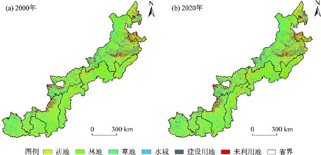
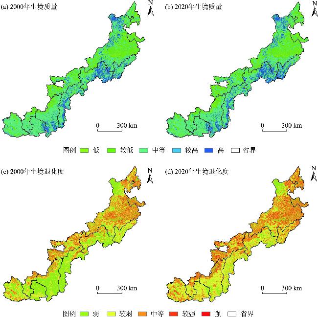
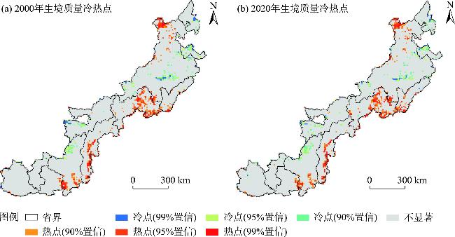
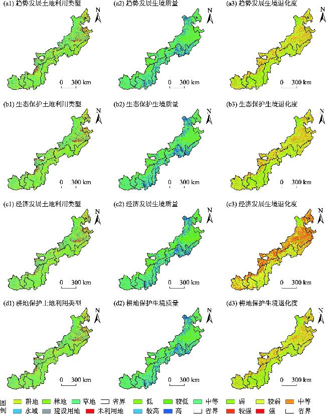
探究脆弱区生境质量变化过程及未来情景格局对于研究区生态环境科学保护具有重要意义。本研究基于土地利用数据、FLUS-InVEST模型及空间自相关方法,分析中国北方农牧交错带2000—2020年生境质量时空格局,并对2040年生境质量进行多情景模拟。结果表明:(1) 草地是研究区的主要土地类型,占比超过41%。2000—2020年研究区耕地变化最为显著,面积减少10157 km2,林地和建设用地面积有所增加。(2) 研究区东南边界生境质量相对较高;2000—2020年平均生境质量变化不大,但生境质量较低等级和较高等级的面积分别增加2281 km2和1375 km2,退化度较高的研究区则呈现为点状集中分布在部分建设用地上。(3) 2040年各情景下生境质量呈现出向好趋势,但生态保护情景下生境质量提升最为显著,较高等级面积较2020年增加2514 km2。建议未来土地利用规划和生态环境保护过程中,需重点关注内蒙古东南部、河北北部等生境质量低的区域。
张莹 , 赵媛媛 , 刘如龙 , 王岳 , 丁国栋 . 中国北方农牧交错带生境质量时空演变与情景模拟[J]. 干旱区研究, 2025 , 42(1) : 154 -165 . DOI: 10.13866/j.azr.2025.01.14
The agro-pastoral ecotone of northern China is a typical ecologically vulnerable region. It is important to explore the spatiotemporal change in habitat quality for the scientific protection of the ecology and environment. This study analyzed the spatiotemporal patterns of habitat quality during the period 2000-2020, and simulated the future land use and habitat quality under various scenarios until 2040, based on the land-use data, FLUS-InVEST model, and spatial autocorrelation method. The results showed that (1) Grassland was the main land-use type in the region, accounting for more than 41% of land use. The cultivated land area accounted for more than 32% and the forest land area accounted for more than 16%. During the 2000-2020 period, the cultivated land changed the most, decreasin by 10157 km2, where the unused land changed the least with an area reduction of 771 km2. The areas of grassland and construction land had increased. (2) The habitat quality in the southeast boundary of the region was relatively high. From 2000 to 2020, the average habitat quality index changed from 0.498 to 0.494, indicating a slight decrease. The area with low habitat quality increased by 2281 km2 and that with high grade habitat increased by 1375 km2. The areas with a high degree of degradation showed a point distribution and were mainly concentrated in some construction land. (3) In 2040, the habitat quality is projected to improve in each scenario, but the habitat quality will improve the most in the ecological protection scenario. The area of high grade habitat increased by 2514 km2 relative to that in 2020. In the trend development scenario, the relatively low ecological quality area would be reduced by up to 162625 km2 relative to that in 2020. The area under cultivation, grassland, and unused land under the trend development and economic development scenarios will not change. The area of forest land under the ecological protection scenario was the largest, being 18547 km2 more than that under the trend development scenario. In light of these findings, it is suggested that in future land-use planning and ecological environmental protection, we should focus on the areas with low habitat quality in the southeast of Inner Mongolia and northern of Hebei.
表1 生境威胁因子的影响范围及其权重Tab. 1 Impact range and weight of habitat constraint factors |
| 威胁源 | 权重 | 最大影响距离/km | 衰退类型 |
|---|---|---|---|
| 耕地 | 0.21 | 2 | 线性衰退 |
| 城乡居民点 | 0.32 | 5 | 指数衰退 |
| 未利用地 | 0.32 | 10 | 线性衰退 |
表2 不同威胁因子下生境适宜性以及相对敏感度Tab. 2 Habitat suitability and relative sensitivity under different threat factors |
| 土地利用类型 | 生境适宜度 | 敏感度 | ||
|---|---|---|---|---|
| 耕地 | 城乡居民点 | 未利用地 | ||
| 耕地 | 0.5 | 0.3 | 0.4 | 0.3 |
| 林地 | 0.9 | 0.6 | 0.8 | 0.8 |
| 草地 | 0.5 | 0.5 | 0.55 | 0.6 |
| 水域 | 0.8 | 0.7 | 0.8 | 0.9 |
| 城乡居民点 | 0 | 0 | 0 | 5 |
| 未利用地 | 0 | 0 | 0 | 0 |
注:未利用地包括沙地、盐碱地、沼泽地、裸岩石质地、裸土地、戈壁和其他。 |
表3 四种情景下土地利用类型限制转移矩阵设置Tab. 3 Restricted transfer matrix setting for the various land-use types under the four scenarios |
| 类型 | 趋势发展 | 经济发展 | |||||||||||
|---|---|---|---|---|---|---|---|---|---|---|---|---|---|
| 耕地 | 林地 | 草地 | 水域 | 建设用地 | 未利用地 | 耕地 | 林地 | 草地 | 水域 | 建设用地 | 未利用地 | ||
| 耕地 | 1 | 0 | 1 | 0 | 1 | 1 | 1 | 0 | 1 | 0 | 1 | 1 | |
| 林地 | 0 | 1 | 1 | 0 | 1 | 1 | 1 | 1 | 1 | 0 | 0 | 0 | |
| 草地 | 1 | 1 | 1 | 1 | 1 | 1 | 1 | 1 | 1 | 1 | 1 | 1 | |
| 水域 | 0 | 1 | 1 | 1 | 1 | 1 | 1 | 0 | 1 | 1 | 0 | 1 | |
| 建设用地 | 1 | 0 | 1 | 0 | 1 | 1 | 0 | 0 | 0 | 0 | 1 | 0 | |
| 未利用地 | 1 | 1 | 1 | 0 | 1 | 1 | 1 | 1 | 1 | 0 | 1 | 1 | |
| 类型 | 耕地保护 | 生态保护 | |||||||||||
| 耕地 | 林地 | 草地 | 水域 | 建设用地 | 未利用地 | 耕地 | 林地 | 草地 | 水域 | 建设用地 | 未利用地 | ||
| 耕地 | 1 | 0 | 0 | 0 | 0 | 0 | 1 | 0 | 0 | 0 | 0 | 0 | |
| 林地 | 1 | 1 | 1 | 0 | 0 | 1 | 0 | 1 | 0 | 0 | 0 | 0 | |
| 草地 | 1 | 1 | 1 | 0 | 1 | 1 | 0 | 1 | 1 | 1 | 0 | 0 | |
| 水域 | 1 | 0 | 0 | 1 | 0 | 1 | 0 | 0 | 0 | 1 | 0 | 0 | |
| 建设用地 | 0 | 0 | 0 | 0 | 1 | 0 | 0 | 0 | 0 | 0 | 1 | 0 | |
| 未利用地 | 1 | 1 | 1 | 1 | 1 | 1 | 1 | 1 | 1 | 1 | 1 | 1 | |
注:转移矩阵中1代表允许转化,0代表不能转化。 |
图2 2000年和2020年北方农牧交错带土地利用分布Fig. 2 Land use distribution of the agro-pastoral ecotone of northern China in 2000 and 2020 |
表4 2000—2020年北方农牧交错带土地利用类型面积转移矩阵Tab. 4 Land use change matrix in the agro-pastoral ecotone of northern China from 2000 to 2020 /km2 |
| 2000年 | 2020年 | |||||
|---|---|---|---|---|---|---|
| 耕地 | 林地 | 草地 | 水域 | 建设用地 | 未利用地 | |
| 耕地 | 206085 | 6804 | 16922 | 810 | 5610 | 871 |
| 林地 | 3359 | 99784 | 4880 | 175 | 722 | 186 |
| 草地 | 13991 | 9789 | 263569 | 445 | 2874 | 2354 |
| 水域 | 852 | 178 | 340 | 9226 | 152 | 1185 |
| 建设用地 | 1226 | 170 | 323 | 37 | 11859 | 46 |
| 未利用地 | 1436 | 273 | 2873 | 288 | 537 | 35977 |
表5 2020年和2040年各情景下北方农牧交错带土地利用类型面积Tab. 5 The land use areas under different scenarios in 2020 and 2040 in the agro-pastoral ecotone of northern China /km2 |
| 土地利用类型 | 2020年 | 2040年 | |||
|---|---|---|---|---|---|
| 趋势发展 | 生态保护 | 经济发展 | 耕地保护 | ||
| 耕地 | 226956 | 223700 | 227286 | 223700 | 227146 |
| 林地 | 117012 | 100628 | 119175 | 104986 | 101452 |
| 草地 | 288918 | 306667 | 288756 | 306665 | 306665 |
| 水域 | 10983 | 10578 | 10985 | 10886 | 10968 |
| 建设用地 | 21756 | 26424 | 21791 | 21756 | 21761 |
| 未利用地 | 40619 | 38247 | 38251 | 38251 | 38252 |
表6 2020年和2040年各情景下北方农牧交错带不同等级的生境质量面积Tab. 6 Different levels of habitat quality under different scenarios in 2040 and 2020 in the agro-pastoral ecotone of northern China /km2 |
| 生境质量 | 2020年 | 2040年 | |||
|---|---|---|---|---|---|
| 趋势发展 | 生态保护 | 经济发展 | 耕地保护 | ||
| 低 | 62375 | 64671 | 60042 | 60007 | 60013 |
| 较低 | 144609 | 105034 | 107312 | 145490 | 107416 |
| 中等 | 380003 | 438444 | 423420 | 392848 | 439357 |
| 较高 | 24608 | 25162 | 27122 | 22523 | 23719 |
| 高 | 94649 | 72933 | 88348 | 85376 | 75739 |
| [1] |
赵哈林, 周瑞莲, 张铜会, 等. 我国北方农牧交错带的草地植被类型、特征及其生态问题[J]. 中国草地, 2003, 25(3): 2-9.
[
|
| [2] |
苏志珠, 马义娟, 刘梅. 中国北方农牧交错带形成之探讨[J]. 山西大学学报(自然科学版), 2003, 26(3): 269-273.
[
|
| [3] |
崔潇, 王永生, 施琳娜. 北方农牧交错带人地系统耦合协调的时空特征及障碍因子[J]. 农业资源与环境学报, 2023, 40(1): 206-217.
[
|
| [4] |
任涵, 张静静, 朱文博, 等. 太行山淇河流域土地利用变化对生境的影响[J]. 地理科学进展, 2018, 37(12): 1693-1704.
[
|
| [5] |
|
| [6] |
吴健生, 曹祺文, 石淑芹, 等. 基于土地利用变化的京津冀生境质量时空演变[J]. 应用生态学报, 2015, 26(11): 3457-3466.
[
|
| [7] |
|
| [8] |
王志强, 陈志超, 郝成元. 基于HSI模型的扎龙国家级自然保护区丹顶鹤繁殖生境适宜性评价[J]. 湿地科学, 2009, 7(3): 197-201.
[
|
| [9] |
白晓娟, 陈海, 刘迪, 等. 基于MaxEnt模型的生态系统服务需求及其簇的空间分异——以陕西省米脂县为例[J]. 生态学报, 2023, 43(7): 2745-2755.
[
|
| [10] |
谢怡凡, 姚顺波, 邓元杰, 等. 延安市退耕还林(草)工程对生境质量时空格局的影响[J]. 中国生态农业学报, 2020, 28(4): 575-586.
[
|
| [11] |
郑亚平, 张俊华, 田惠文, 等. 大别山区生境质量时空特征及自然—人为因素驱动机制[J]. 环境科学, 2024, 45(4): 2268-2279.
[
|
| [12] |
王鹏, 秦思彤, 胡慧蓉. 近30 a拉萨河流域土地利用变化和生境质量的时空演变特征[J]. 干旱区研究, 2023, 40(3): 492-503.
[
|
| [13] |
苏迎庆, 刘庚, 赵景波, 等. 基于FLUS模型的汾河流域生态空间多情景模拟预测[J]. 干旱区研究, 2021, 38(4): 1152-1161.
[
|
| [14] |
荣月静, 张慧, 王岩松. 基于Logistic-CA-Markov与InVEST 模型对南京市土地利用与生物多样性功能模拟评价[J]. 水土保持研究, 2016, 23(3): 82-89.
[
|
| [15] |
刘孟竹, 张红娟, 任贺宇, 等. 退耕还林背景下北方农牧交错带土壤保持功能时空变化[J]. 水土保持研究, 2021, 28(5): 172-178.
[
|
| [16] |
邱嘉琦, 于德永. 中国北方农牧交错带生态系统服务空间格局及影响因子—以内蒙古中西部地区为例[J]. 生态学报, 2023, 43(18): 7598-7609.
[
|
| [17] |
白舒婷. 中国北方农牧交错带生态系统服务时空变化及权衡与协同研究[D]. 北京: 中国科学院大学, 2023.
[
|
| [18] |
石晓丽, 史文娇. 北方农牧交错带界线的变迁及其驱动力研究进展[J]. 农业工程学报, 2018, 34(20): 1-11.
[
|
| [19] |
徐新良, 刘纪远, 张树文, 等. 中国多时期土地利用土地覆被遥感监测数据集(CNLUCC)[DB/OL]. 资源与环境数据云平台, 2018.
[
|
| [20] |
徐苏, 张永勇, 窦明, 等. 长江流域土地利用时空变化特征及其径流效应[J]. 地理科学进展, 2017, 36(4): 426-436.
[
|
| [21] |
|
| [22] |
王琦琨, 武玮, 杨雪琪, 等. 陕西省生境质量时空演变及驱动机制分析[J]. 干旱区研究, 2022, 39(5): 1684-1694.
[
|
| [23] |
张晓东, 武丹, 王莹, 等. 耦合InVEST与Geodetector模型的银川市生境质量时空演变特征及影响因子研究[J]. 干旱区地理, 2024, 47(7): 1242-1251.
[
|
| [24] |
|
| [25] |
|
| [26] |
奥勇, 蒋嶺峰, 白召弟, 等. 基于格网GIS的黄河流域土地生态质量综合评价[J]. 干旱区地理, 2022, 45(1): 164-175.
[
|
| [27] |
|
| [28] |
|
| [29] |
李井浩, 柳书俊, 王志杰. 基于FLUS和InVEST模型的云贵高原土地利用与生态系统服务时空变化多情景模拟研究[J]. 水土保持研究, 2024, 31(3): 287-298.
[
|
| [30] |
史志刚. 大别山区水土保持工作探析[J]. 中国水利, 2012, 62(12): 31-32.
[
|
| [31] |
|
| [32] |
张晓龙, 周继华, 刘焱序, 等. 气候变化和人类活动对内蒙古灌木林分布的影响[J]. 生态学报, 2020, 40(10): 3237-3248.
[
|
| [33] |
苏军德, 赵晓冏, 李国霞, 等. 祁连山国家自然保护区生境质量时空特征及驱动因素分析[J]. 中国环境科学, 2024, 44(5): 2595-2605.
[
|
/
| 〈 |
|
〉 |
