
基于Sentinel-2的依连哈比尔尕冰川变化监测
|
李若楠(2001-),女,硕士研究生,主要从事干旱区冰川变化研究. E-mail: 1595499117@qq.com |
收稿日期: 2023-10-23
修回日期: 2024-01-30
网络出版日期: 2025-08-12
基金资助
新疆维吾尔自治区自然科学基金(2023D01E18)
天山英才科技创新团队(2022TSYCTD0006)
第三次新疆综合科学考察(2021xjkk1400)
Monitoring the glacier changes in Yilian Habirga Mountain using Sentinel-2 data
Received date: 2023-10-23
Revised date: 2024-01-30
Online published: 2025-08-12
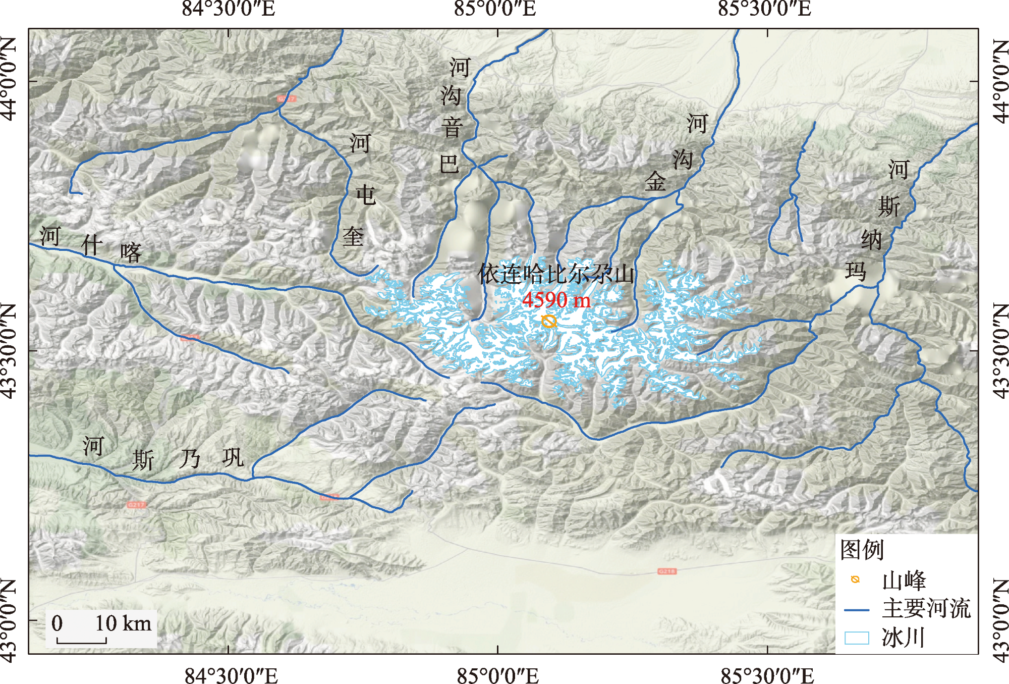
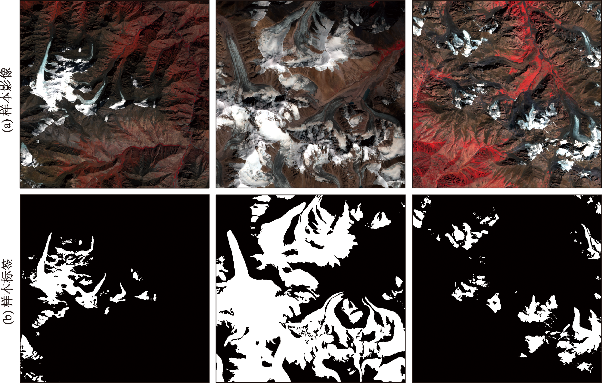
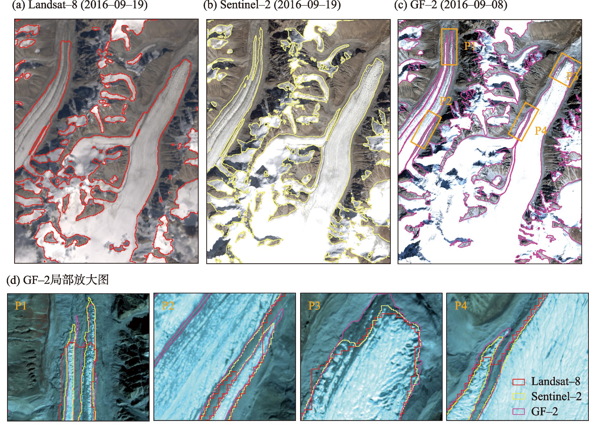
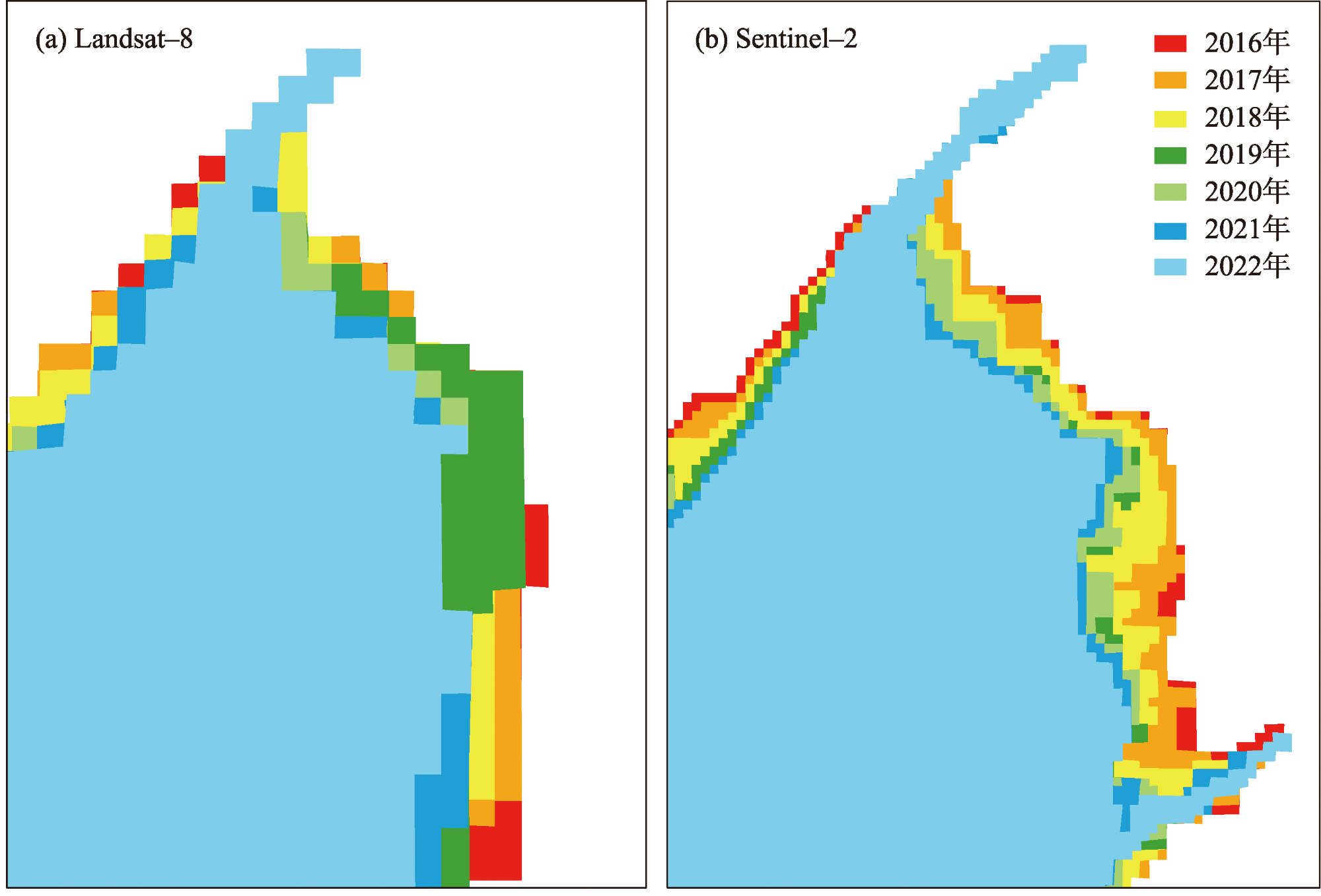
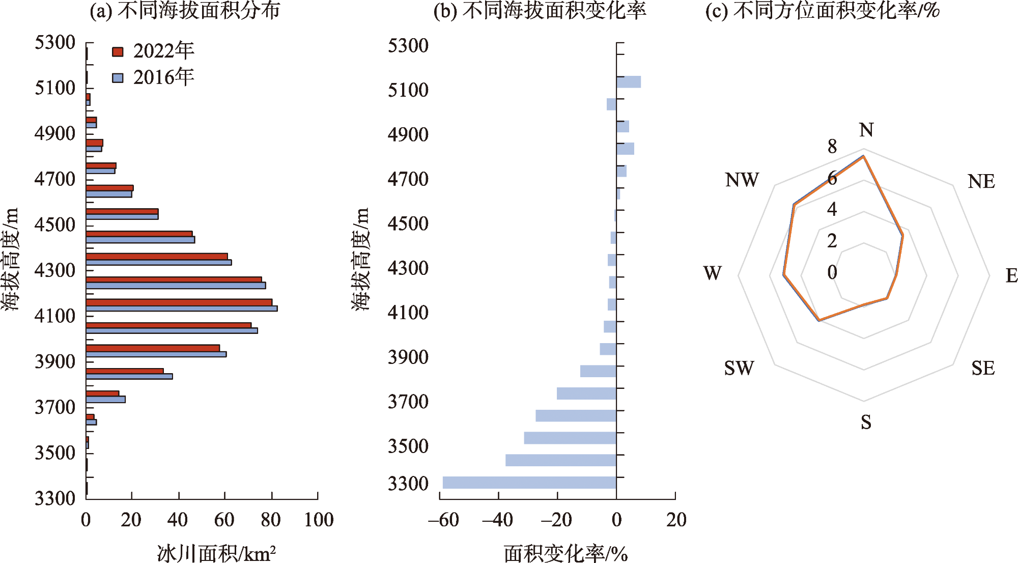
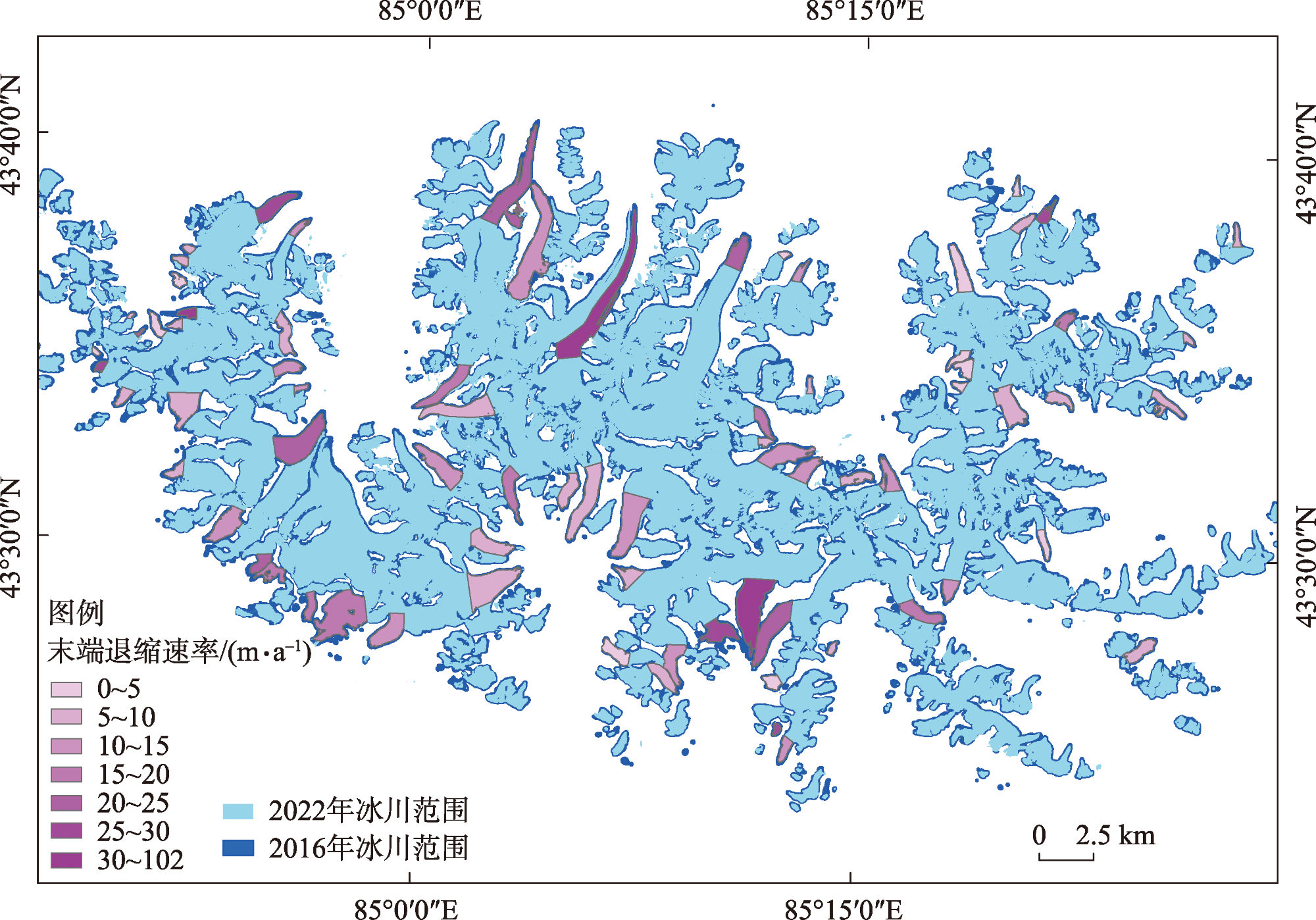
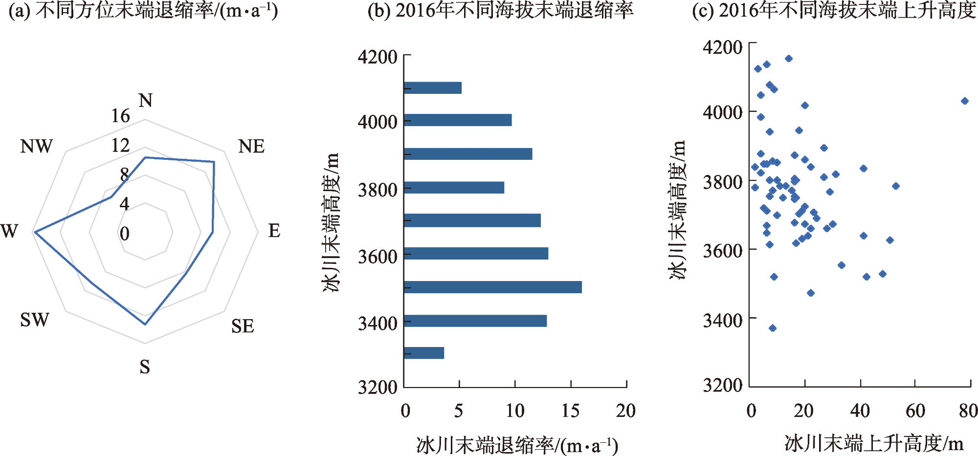
高分时序遥感对于监测冰川变化具有重要作用。本文利用2016—2022年Sentinel-2多时相卫星影像和D-UNet语义分割模型提取依连哈比尔尕冰川变化信息,并与时相相近的Landsat遥感数据的提取结果对比,比较Sentinel-2和Landsat在冰川制图的精度差异,在此基础上选择75条典型冰川分析近期研究区冰川总面积和冰川末端的变化特征。结果表明:(1) Sentinel-2冰川制图总体精度为95.0%,相同条件下比Landsat-8提高5%~10%。(2) 2016—2022年研究区冰川年平均面积退缩率为0.75%±0.69%,其中,海拔4600 m以下的区域为冰川面积减少的区域,海拔越低面积退缩率越大。(3) 近6 a 75条典型冰川末端的平均高度上升了17.75 m,长度平均退缩了11.39±2.36 m·a-1,其中,偏西、东北和南的退缩最为显著,分别为15.49±2.36 m·a-1、13.95±2.36 m·a-1和13.14±2.36 m·a-1,冰川末端退缩速率随海拔的升高而降低。
关键词: 冰川末端; 深度学习; 时空特征; Sentinle-2; 依连哈比尔尕山
李若楠 , 李均力 , 李爽爽 , 刘帅琪 , 都伟冰 . 基于Sentinel-2的依连哈比尔尕冰川变化监测[J]. 干旱区研究, 2024 , 41(6) : 940 -950 . DOI: 10.13866/j.azr.2024.06.04
High-resolution time-series remote sensing plays a vital role in monitoring glacier changes. In this paper, Sentinel-2 multitemporal satellite images from 2016-2022 were used along with the D-UNet semantic segmentation model to extract the glacier change information of Yilian Habirga. These results were compared with the Landsat remote sensing data of the similar temporal phase to ascertain any differences in the accuracies of Sentinel-2 and Landsat for glacier mapping. Based on these findings, 75 typical glaciers were selected to analyze the change-related characteristics of the total glacier area and glacier end in the recent study area. The results show that (1) The overall accuracy of Sentinel-2 glacier mapping was 95.0%, which is 5%-10% higher than Landsat-8 under the same conditions. (2) The average area retreat rate of glaciers in the study area from 2016 to 2022 was 0.75%±0.69%·a-1, in which the region<4600 m above sea level was that of glacier area reduction; the lower the altitude, the greater the area retreat rate. (3) In the last 6 years, the average heights of the 75 typical glacier ends rose by 17.75 m, and the average lengths reduced by 11.39 ± 2.36 m·a-1. Among these, the retreats in the west, northeast, and south were the most significant, which were 15.49 ± 2.36 m·a-1, 13.95 ± 2.36 m·a-1, and 13.14 ± 2.36 m·a-1, respectively; the rate of the glacier end retreated with an increase in the elevation and the decreased.
表1 冰川制图选择的遥感数据获取时间Tab. 1 The selected dates of remote sensing data for glacier mapping |
| 遥感数据类型 | 获取时间/年-月-日 | |||||||
|---|---|---|---|---|---|---|---|---|
| Landsat-8 | 2016-09-19 | 2017-07-29 | 2018-08-17 | 2019-10-07 | 2020-08-22 | 2021-07-24 | 2022-07-11 | |
| Sentienl-2 | 2016-09-19 | 2017-07-08 | 2018-08-20 | 2019-08-30 | 2020-07-17 | 2021-07-25 | 2022-07-22 | |
表2 不同遥感数据的冰川制图精度对比Tab. 2 Comparisons of mapping accuracies with different types of satellite data |
| 数据类别 | 评价指标 | ||||
|---|---|---|---|---|---|
| PA | UA | OA | F1 | IoU | |
| Sentinel-2 | 0.831 | 0.851 | 0.950 | 0.835 | 0.768 |
| Landsat-8 | 0.748 | 0.832 | 0.916 | 0.780 | 0.679 |
| [1] |
|
| [2] |
李开明, 陈世峰, 康玲芬, 等. 中国大陆型冰川和海洋型冰川变化比较分析——以天山乌鲁木齐河源1号冰川和玉龙雪山白水河1号冰川为例[J]. 干旱区研究, 2018, 35(1): 12-19.
[
|
| [3] |
王利辉, 秦翔, 陈记祖, 等. 1961—2013年祁连山区冰川年物质平衡重建[J]. 干旱区研究, 2021, 38(6): 1524-1533.
[
|
| [4] |
都伟冰, 张世琼, 李均力, 等. 中亚高山冰川表面高程变化时序重建[J]. 干旱区研究, 2022, 39(3): 676-683.
[
|
| [5] |
|
| [6] |
李忠勤, 李开明, 王林. 新疆冰川近期变化及其对水资源的影响研究[J]. 第四纪研究, 2010, 30(1): 96-106.
[
|
| [7] |
张慧, 李忠勤, 牟建新, 等. 近50年新疆天山奎屯河流域冰川变化及其对水资源的影响[J]. 地理科学, 2017, 37(11): 1771-1777.
[
|
| [8] |
赵贵宁, 张正勇, 刘琳, 等. 基于多源遥感数据的玛纳斯河流域冰川物质平衡变化[J]. 地理学报, 2020, 75(1): 98-112.
[
|
| [9] |
李志杰, 王宁练, 常佳雯. 巴托拉等冰川的新近变化及对中巴公路的影响[J]. 干旱区研究, 2022, 39(6): 1986-1995.
[
|
| [10] |
|
| [11] |
|
| [12] |
|
| [13] |
张震. 基于遥感和GIS的东帕米尔高原冰川冰量变化研究[J]. 测绘学报, 2021, 50(7): 992.
[
|
| [14] |
李振林, 秦翔, 王晶, 等. 2004—2015年祁连山脉东部冷龙岭冰川遥感监测[J]. 测绘科学, 2018, 43(6): 45-51.
[
|
| [15] |
怀保娟, 李忠勤, 孙美平, 等. 多种遥感分类方法提取冰川边界探讨——以喀纳斯河源地区为例[J]. 干旱区研究, 2013, 30(2): 372-377.
[
|
| [16] |
|
| [17] |
|
| [18] |
|
| [19] |
刘沼辉, 齐忠华. 基于光学影像数据的南极冰川监测研究进展[J]. 测绘与空间地理信息, 2022, 45(S1): 17-21.
[
|
| [20] |
|
| [21] |
|
| [22] |
王忠武, 王志盼, 尤淑撑, 等. Landsat影像冰川提取的上下文感知语义分割网络法[J]. 测绘学报, 2020, 49(12): 1575-1582.
[
|
| [23] |
|
| [24] |
|
| [25] |
李珊珊. 中国天山不同地区典型冰川末端变化特征及其空间差异研究[D]. 兰州: 西北师范大学, 2013.
[
|
| [26] |
李珊珊, 张明军, 李忠勤, 等. 1960—2009年中国天山现代冰川末端变化特征[J]. 干旱区研究, 2013, 30(2): 378-384.
[
|
| [27] |
|
| [28] |
黄晓然, 包安明, 郭浩, 等. 近20 a中国天山东段典型冰川变化及其气候响应[J]. 干旱区研究, 2017, 34(4): 870-880.
[
|
| [29] |
|
| [30] |
赵景啟, 满苏尔·沙比提, 麦丽开·艾麦提, 等. 1992—2017年托木尔峰国家级自然保护区冰川变化[J]. 干旱区研究, 2020, 37(4): 1079-1086.
[
|
| [31] |
施雅风, 王宗太, 刘潮海, 等. 简明中国冰川目录[M]. 上海: 上海科学普及出版社, 2005: 194.
[
|
| [32] |
刘时银, 郭万钦, 许君利. 中国第二次冰川编目数据集(V1.0)[DB/OL]. 国家冰川冻土沙漠科学数据中心, 2019.
[
|
| [33] |
都伟冰, 李均力, 包安明, 等. 高山冰川多时相多角度遥感信息提取方法[J]. 测绘学报, 2015, 44(1): 59-66.
[
|
| [34] |
|
| [35] |
汪志文. 基于深度学习的高分辨率遥感影像语义分割的研究与应用[D]. 北京: 北京邮电大学, 2019.
[
|
| [36] |
王梓霏, 柯长青. 基于深度学习的Sentinel-1A影像冰川识别[J]. 遥感信息, 2022, 37(4): 43-50.
[
|
| [37] |
聂勇, 张镱锂, 刘林山, 等. 近30年珠穆朗玛峰国家自然保护区冰川变化的遥感监测[J]. 地理学报, 2010, 65(1): 13-28.
[
|
| [38] |
邢武成, 李忠勤, 张慧, 等. 1959年来中国天山冰川资源时空变化[J]. 地理学报, 2017, 72(9): 1594-1605.
[
|
| [39] |
田梦祺, 段克勤, 石培宏. 基于Google Earth Engine平台的青藏高原冰川变化研究——以普若岗日冰原为例[J]. 地理科学, 2023, 43(6): 943-951.
[
|
| [40] |
樊晓兵, 彦立利, 徐京华, 等. 基于多源数据的近50 a玛纳斯河流域冰川变化分析[J]. 冰川冻土, 2015, 37(5): 1188-1198.
[
|
| [41] |
吴坤鹏, 刘时银, 朱钰, 等. 基于无人机摄影测量的梅里雪山明永冰川末端表面高程动态监测[J]. 地理科学进展, 2021, 40(9): 1581-1589.
[
|
| [42] |
田浩. 玛纳斯河流域冰川几何形态特征及稳定性研究[D]. 石河子: 石河子大学, 2022.
[
|
| [43] |
焦克勤, 井哲帆, 成鹏, 等. 天山奎屯河哈希勒根51号冰川变化监测结果分析[J]. 干旱区地理, 2009, 32(5): 733-738.
[
|
/
| 〈 |
|
〉 |