
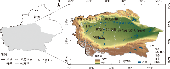
近20 a塔里木河流域人类活动及景观生态风险时空变化
|
杨荣钦(1999-),男,硕士研究生,主要从事水文水资源研究. E-mail: 320222290@xjau.edu.cn |
收稿日期: 2023-11-21
修回日期: 2024-03-03
网络出版日期: 2025-08-12
基金资助
新疆维吾尔自治区重点研发专项(2022B03024)
国家自然科学基金项目(52269007)
国家自然科学基金项目(51969029)
自治区天山英才计划第三期
Temporal and spatial variations of human activities and landscape ecological risks in the Tarim River Basin, China, during the last 20 years
Received date: 2023-11-21
Revised date: 2024-03-03
Online published: 2025-08-12
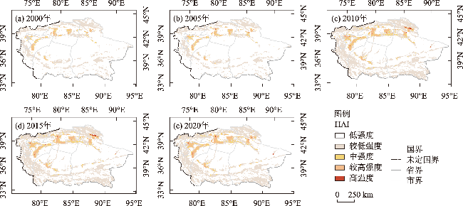
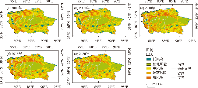
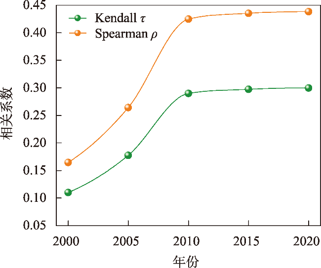
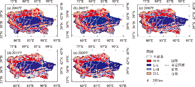
人类活动是区域生态风险加剧的重要因素,亟需探讨人类活动强度对景观生态风险影响。本文以塔里木河流域为研究对象,基于近20 a的5期土地利用、人口空间分布和夜间灯光数据,引入土地利用程度综合指数以改进人类活动强度(HAI)评价体系,定量评价强人类活动下的流域景观生态风险(LER)时空变化,并结合Copula函数以及双变量局部空间自相关模型,揭示LER与HAI的时空关联性。结果表明:(1) 近20 a塔里木河流域HAI显著提高,强人类活动主要分布于水资源较丰富的绿洲区;流域人类活动强度呈增加趋势,低强度区面积占比减少17.88%、中高强度区面积占比增加3.57%。(2) 塔里木河流域LER整体呈四周高、中部低的特征,高风险区主要分布于人类活动较为频繁的绿洲区;流域LER在2015年前呈加剧趋势,但2010年后加剧趋势减缓,2015年后改善趋势逐步显现。(3) 近20 a HAI与LER呈正相关关系,人类活动对LER的正向效应不断增加;2010年后二者关系的增加趋势趋于平缓,正向效应出现由增到减的过渡阶段;空间上H-H聚集区呈增加趋势,分布格局由分散变为集中;2015年后,L-L和H-L聚集区缓慢增加,L-H聚集区缓慢减少。研究结果可为塔里木河流域土地资源合理利用、景观生态保护提供科学参考。
杨荣钦 , 肖玉磊 , 池苗苗 , 穆振侠 . 近20 a塔里木河流域人类活动及景观生态风险时空变化[J]. 干旱区研究, 2024 , 41(6) : 1010 -1020 . DOI: 10.13866/j.azr.2024.06.10
Human activity is an essential factor in the intensification of regional ecological risk. Hence, it is urgent to discuss the impact of human activity intensity (HAI) on the landscape ecological risk. This paper took the Tarim River Basin as the research object. Based on the land use, population spatial distribution, and night light data during five periods from 2000 to 2020, it introduces the comprehensive index of land use degree to improve the evaluation system of HAI and quantitatively evaluates the temporal and spatial changes of landscape ecological risk (LER) in the basin under robust human activity. Combined with the Copula function and bivariate local spatial autocorrelation model, the spatiotemporal correlation between LER and HAI is revealed. The results showed that (1) The HAI in the Tarim River Basin enhanced markedly in the past 20 years, and extensive human activities were mainly distributed in the oasis areas with rich water resources. The intensity of human activities in the basin increased, with the proportion of low-intensity areas diminished by 17.88% and that of medium-high-intensity areas elevated by 3.57%. (2) The overall LER in the Tarim River Basin was characterized by a high surrounding area and a low central area, and the high-risk area was mainly distributed in the oasis areas with more frequent human activities. The LER in the basin intensified before 2015, which slowed down after 2010, and gradually emerged after 2015. (3) The HAI and LER were positively correlated during the past 20 years, and the positive effect of human activities on LER was enhanced. After 2010, the increasing correlation between the two flattened, and a positive effect appeared in the stage of transition from increase to decrease. The H-H cluster area elevated in space, and the distribution pattern changed from dispersion to concentration. After 2015, the L-L and H-L cluster areas slowly increased, unlike the L-H cluster areas. The results can provide a scientific reference for the rational use of land resources and protection of the landscape ecology in the Tarim River Basin.
表1 塔里木河流域2000—2020年土地利用类型转移矩阵Tab. 1 Transfer matrix of land use types in Tarim River Basin from 2000 to 2020 /km2 |
| 2000年 | 2020年 | ||||||
|---|---|---|---|---|---|---|---|
| 耕地 | 林地 | 草地 | 水域 | 建设用地 | 未利用土地 | 总计 | |
| 耕地 | - | 1098.66 | 1425.45 | 203.65 | 1297.06 | 542.65 | 4567.47 |
| 林地 | 2071.37 | - | 5722.53 | 272.24 | 76.65 | 1808.06 | 9950.85 |
| 草地 | 12165.10 | 6037.15 | - | 3734.20 | 289.33 | 86713.10 | 108938.87 |
| 水域 | 490.03 | 231.77 | 7353.46 | - | 71.48 | 15430.09 | 23576.83 |
| 建设用地 | 822.63 | 85.20 | 68.18 | 8.33 | - | 36.20 | 1020.54 |
| 未利用土地 | 4680.59 | 1418.17 | 84866.90 | 5705.87 | 845.78 | - | 97517.29 |
| 总计 | 20229.72 | 8870.95 | 99436.50 | 9924.28 | 2580.30 | 104530.09 | 245571.85 |
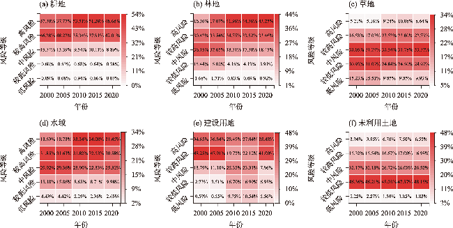
表2 各年平均ERI和LER等级面积占比Tab. 2 Average area ratio of ERI and LER grades in each year |
| 年份 | 平均 ERI | LER各等级面积占比/% | ||||
|---|---|---|---|---|---|---|
| 低风险 | 较低风险 | 中风险 | 较高风险 | 高风险 | ||
| 2000年 | 0.075 | 5.79 | 39.25 | 31.64 | 17.37 | 5.94 |
| 2005年 | 0.075 | 5.86 | 39.09 | 31.19 | 17.84 | 6.03 |
| 2010年 | 0.077 | 3.95 | 38.51 | 27.48 | 19.78 | 10.28 |
| 2015年 | 0.078 | 3.93 | 37.98 | 26.72 | 20.24 | 11.14 |
| 2020年 | 0.078 | 3.91 | 38.42 | 27.49 | 20.15 | 10.03 |
表3 各Copula函数平方欧式距离Tab. 3 Square Euclidean distance of each Copula function |
| 函数类型 | 2000年 | 2005年 | 2010年 | 2015年 | 2020年 |
|---|---|---|---|---|---|
| Frank Copula | 9.50 | 27.57 | 26.66 | 22.60 | 23.18 |
| Clayton Copula | 17.34 | 36.57 | 28.92 | 24.75 | 24.87 |
| Gumbel Copula | 14.22 | 37.62 | 51.95 | 45.32 | 45.71 |
| t Copula | 10.22 | 29.71 | 31.04 | 26.67 | 27.25 |
| Gaussian Copula | 13.18 | 37.38 | 48.84 | 41.18 | 40.82 |
注:加粗数据表示函数最优。 |
| [1] |
曹顺爱, 吴次芳, 余万军. 土地生态服务价值评价及其在土地利用布局中的应用——以杭州市萧山区为例[J]. 水土保持学报, 2006, 20(2): 197-200.
[
|
| [2] |
|
| [3] |
|
| [4] |
刘坤, 于赐刚, 张艺凡, 等. 青藏高原自然保护区人类活动及其影响研究现状与热点[J]. 应用与环境生物学报, 2022, 28(2): 508-516.
[
|
| [5] |
|
| [6] |
彭建, 党威雄, 刘焱序, 等. 景观生态风险评价研究进展与展望[J]. 地理学报, 2015, 70(4): 664-677.
[
|
| [7] |
徐丽芬, 许学工, 卢亚灵, 等. 基于自然灾害的北京幅综合生态风险评价[J]. 生态环境学报, 2010, 19(11): 2607-2612.
[
|
| [8] |
|
| [9] |
|
| [10] |
|
| [11] |
|
| [12] |
方林, 方斌, 刘艳晓, 等. 长三角地区景观生态风险与人类活动强度的响应及其时空关联[J]. 农业工程学报, 2022, 38(22): 210-219.
[
|
| [13] |
邓铭江. 干旱内陆河流域河湖生态环境复苏关键技术[J]. 中国水利, 2022, 73(7): 21-27.
[
|
| [14] |
彭茹燕, 刘连友, 张宏. 人类活动对干旱区内陆河流域景观格局的影响分析——以新疆和田河中游地区为例[J]. 自然资源学报, 2003, 18(4): 492-498.
[
|
| [15] |
刘新华, 徐海量, 凌红波, 等. 塔里木河干流河道生态需水量研究[J]. 干旱区研究, 2012, 29(6): 984-991.
[
|
| [16] |
|
| [17] |
邓铭江, 周海鹰, 徐海量, 等. 塔里木河干流上中游丰枯情景下生态水调控研究[J]. 干旱区研究, 2017, 34(5): 959-966.
[
|
| [18] |
杜慧娟, 王光耀, 冉光妍, 等. 面向SDGs的塔里木河流域农业灰水足迹分析[J]. 干旱区研究, 2023, 40(7): 1184-1193.
[
|
| [19] |
邓铭江, 樊自立, 徐海量, 等. 塔里木河流域生态功能区划研究[J]. 干旱区地理, 2017, 40(4): 705-717.
[
|
| [20] |
陈泓瑾, 刘琳, 张正勇, 等. 天山北坡人类活动强度与地表温度的时空关联性[J]. 地理学报, 2022, 77(5): 1244-1259.
[
|
| [21] |
庄大方, 刘纪远. 中国土地利用程度的区域分异模型研究[J]. 自然资源学报, 1997, 12(2): 10-16.
[
|
| [22] |
|
| [23] |
张学斌, 石培基, 罗君, 等. 基于景观格局的干旱内陆河流域生态风险分析——以石羊河流域为例[J]. 自然资源学报, 2014, 29(3): 410-419.
[
|
| [24] |
朱瑞广, 吕大刚. 基于Copula函数的主余震地震动强度参数相关性分析[J]. 工程力学, 2019, 36(2): 114-123.
[
|
| [25] |
张龄月. 一类有关随机向量间非线性相依度量的研究及其应用[D]. 大连: 大连理工大学, 2022.
[
|
| [26] |
郑德凤, 郝帅, 吕乐婷, 等. 三江源国家公园生态系统服务时空变化及权衡-协同关系[J]. 地理研究, 2020, 39(1): 64-78.
[
|
| [27] |
钟绍卓, 孙浩源. 不同情景下祁连山国家级自然保护区生态系统服务时空变化及权衡与协同关系[J]. 水土保持研究, 2023, 30(5): 358-369.
[
|
| [28] |
|
| [29] |
|
| [30] |
|
| [31] |
李路, 孙桂丽, 陆海燕, 等. 喀什绿洲土地利用空间格局变化特征分析[J]. 西南大学学报(自然科学版), 2020, 42(5): 141-150.
[
|
| [32] |
师君银, 马勇刚, 许仲林. 喀什地区土地利用变化对生境质量的影响[J]. 西南农业学报, 2023, 36(11): 2480-2490.
[
|
| [33] |
王文杰, 张永福, 王慧杰. 基于GIS干旱区绿洲县域土地利用变化生态风险分析——以新疆泽普县为例[J]. 水土保持研究, 2016, 23(6): 216-220, 2.
[
|
| [34] |
朱会义, 李秀彬. 关于区域土地利用变化指数模型方法的讨论[J]. 地理学报, 2003, 58(5): 643-650.
[
|
| [35] |
王鹏, 秦思彤, 胡慧蓉. 近30 a拉萨河流域土地利用变化和生境质量的时空演变特征[J]. 干旱区研究, 2023, 40(3): 492-503.
[
|
| [36] |
赵新风, 徐海量, 张鹏, 等. 塔里木河下游地区不同滴灌频率下沙枣防护林成活率与生长量特征[J]. 林业科学, 2012, 48(10): 150-156.
[
|
| [37] |
邓晓雅, 龙爱华, 高海峰, 等. 塔里木河流域绿色生态空间与景观格局变化研究[J]. 中国水利水电科学研究院学报, 2020, 18(5): 369-376.
[
|
| [38] |
魏靖阳, 於冉, 付丹阳, 等. 成渝城市群景观生态风险与人类活动强度时空关联分析[J]. 安徽农业大学学报, 2023, 50(5): 887-896.
[
|
| [39] |
|
| [40] |
|
/
| 〈 |
|
〉 |