
基于决策树的天山冰湖提取方法研究
|
李梦帆(2002-),男,主要研究方向为资源环境遥感. E-mail: l_mengfan@126.com |
收稿日期: 2024-03-26
修回日期: 2024-06-25
网络出版日期: 2025-08-12
基金资助
国家级大学生创新研究项目(202210755003)
第三次新疆综合科学考察项目(2021xjkk1001)
Research on the extraction method of Tianshan glacier lake based on decision tree
Received date: 2024-03-26
Revised date: 2024-06-25
Online published: 2025-08-12
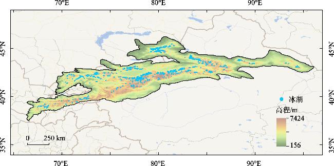
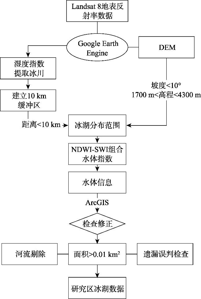
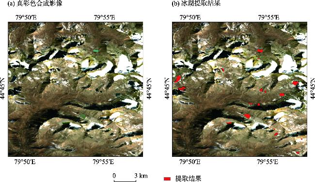
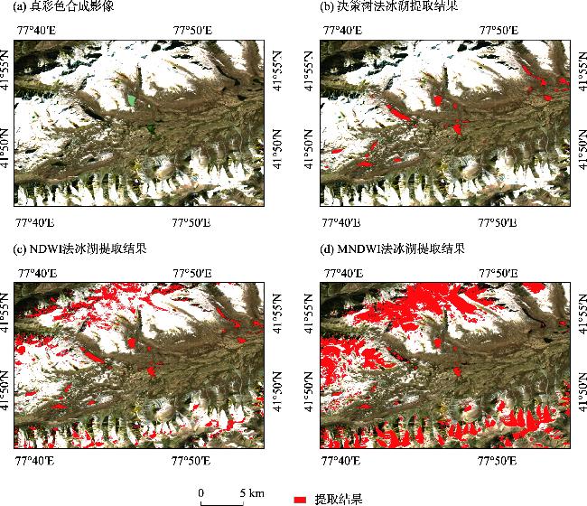
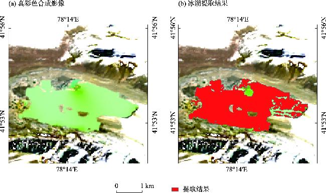
天山位于亚欧大陆中部,是现代冰川的主要分布区之一,该地区冰川融水形成了数量多且分布广泛的冰湖。冰湖是气候变化的重要指示器,也是中国西北干旱与半干旱地区重要的地表水及地下水供给来源。由于地形因素和地物光谱特征的影响,使用单一的水体指数进行遥感影像的冰湖提取时,难以较好地区分出冰湖、山体阴影和积雪。本研究以天山地区为研究区,基于Google Earth Engine云平台,以Landsat 8遥感影像为数据源,根据冰湖的空间位置(缓冲区范围)、地形特征(坡度、高程)以及光谱特征,构建了冰湖决策树提取方法,并与NDWI(归一化水体指数)、MNDWI(改进的归一化水体指数)阈值法进行了精度比较。结果表明:决策树法能够有效减小山体阴影和积雪影响,更有效地提取冰湖信息,提取结果总体精度为89.14%,Kappa系数为0.783,F1分数为87.85%。结合了空间位置、地形特征和光谱特征的决策树方法为冰湖的动态监测与研究分析提供了一种较为高效的提取方法。
关键词: 冰湖提取; 决策树; Google Earth Engine; 天山
李梦帆 , 郑江华 , 钱安良 , 李家辉 , 阿迪力江·帕尔合提 , 王哲 , 马丽莎 , 王南 . 基于决策树的天山冰湖提取方法研究[J]. 干旱区研究, 2024 , 41(10) : 1699 -1707 . DOI: 10.13866/j.azr.2024.10.08
The Tianshan region, located in the middle of the Eurasian continent, is a major distribution area of modern glaciers, and its glacial meltwater has formed a large number of and widespread glacial lakes. Glacial lakes are vital indicators of climate change and an important source of surface and groundwater supply in arid and semi-arid regions of Northwest China. The impact of topographic factors and spectral characteristics of ground objects makes it difficult to distinguish between glacial lakes, mountain shadow, and snow cover when extracting glacial lakes from remote sensing images using a single water index. In this study, based on the Google Earth Engine platform and Landsat 8 remote sensing images as the data source, a decision tree extraction method of the glacial lake was constructed according to the topographic characteristics (slope, elevation, and buffer analysis) and spectral characteristics of the glacial lake. This method was compared with the NDWI and MNDWI threshold methods. Experimental results demonstrated that the decision tree method can effectively reduce the impact of mountain shadow and snow cover and accurately extract glacial lake information. The overall accuracy of the extraction results was 89.14%, the Kappa coefficient was 0.783, and the F1 score was 87.85%. The decision tree method, which combines spatial topographic features and spectral features, is a relatively efficient extraction method for dynamic monitoring and research analysis of glacial lakes.
Key words: glacial lake extraction; decision tree; Google Earth Engine; Tianshan
表1 天山冰湖提取精度混淆矩阵Tab. 1 Tianshan glacial lake extraction accuracy confusion matrix |
| 验证样点 | 总计 | 用户精度/% | ||
|---|---|---|---|---|
| 冰湖 | 非冰湖 | |||
| 冰湖 | 1374 | 4 | 1378 | 99.71 |
| 非冰湖 | 376 | 1746 | 2122 | 82.28 |
| 总计 | 1750 | 1750 | 总体精度:89.14% | |
| 生产者精度/% | 78.51 | 99.77 | Kappa系数:0.783 | |
表2 天山冰湖提取精度Tab. 2 Tianshan glacial lake extraction accuracy |
| 准确率/% | 召回率/% | F1分数/% |
|---|---|---|
| 99.71 | 78.51 | 87.85 |
| [1] |
黄启厅. 干旱区山地冰川—冰湖协同演变遥感监测与气候变化响应机制研究[D]. 北京: 中国科学院大学 (中国科学院遥感与数字地球研究所), 2017.
[
|
| [2] |
李想. 基于 GEE 的近三十年亚洲高山区冰川雪线变化研究[D]. 西安: 西北大学, 2021.
[
|
| [3] |
姚檀栋, 刘时银, 蒲健辰, 等. 高亚洲冰川的近期退缩及其对西北水资源的影响[J]. 中国科学(D辑), 2004, 34(6): 535-543.
[
|
| [4] |
邓海军, 陈亚宁. 中亚天山山区冰雪变化及其对区域水资源的影响[J]. 地理学报, 2018, 73(7): 1309-1323.
[
|
| [5] |
王宗太. 新疆的冰川[J]. 干旱区地理, 1991, 14(1): 18-24.
[
|
| [6] |
姚晓军, 刘时银, 韩磊, 等. 冰湖的界定与分类体系——面向冰湖编目和冰湖灾害研究[J]. 地理学报, 2017, 72(7): 1173-1183.
[
|
| [7] |
陈晨, 郑江华, 刘永强, 等. 近 20 年中国阿尔泰山区冰川湖泊对区域气候变化响应的时空特征[J]. 地理研究, 2015, 34(2): 270-284.
[
|
| [8] |
毕海芸, 王思远, 曾江源, 等. 基于TM影像的几种常用水体提取方法的比较和分析[J]. 遥感信息, 2012, 27(5): 77-82.
[
|
| [9] |
|
| [10] |
骆剑承, 盛永伟, 沈占锋, 等. 分步迭代的多光谱遥感水体信息高精度自动提取[J]. 遥感学报, 2009, 13(4): 610-615.
[
|
| [11] |
|
| [12] |
|
| [13] |
闫斌, 贾洪果, 任文静, 等. 基于NDWI-NDSI组合阈值法的布加岗日冰湖提取及其变化分析[J]. 遥感学报, 2022, 26(11): 2344-2353.
[
|
| [14] |
陈方, 王金晓, 张美美, 等. 基于历史边界的喜马拉雅山脉冰湖提取方法对比研究[J]. 冰川冻土, 2023, 45(4): 1413-1427.
[
|
| [15] |
李宇宸, 张军, 刘陈立. Sentinel-2 影像的云南千湖山细小冰湖提取方法[J]. 测绘科学, 2021, 46(4): 114-120.
[
|
| [16] |
|
| [17] |
|
| [18] |
潘梦, 曹云刚. 高亚洲地区冰湖遥感研究进展与展望[J]. 自然资源遥感, 2021, 33(1): 1-8.
[
|
| [19] |
|
| [20] |
|
| [21] |
|
| [22] |
吴坤鹏. 天山冰湖变化及其影响研究[D]. 湘潭: 湖南科技大学, 2014.
[
|
| [23] |
车涛, 李新,
[
|
| [24] |
陈亚宁, 李稚, 方功焕, 等. 气候变化对中亚天山山区水资源影响研究[J]. 地理学报, 2017, 72(1): 18-26.
[
|
| [25] |
|
| [26] |
|
| [27] |
|
| [28] |
殷永胜, 王欣, 刘时银, 等. 1990—2020年中国冰湖变化特征及影响因素[J]. 湖泊科学, 2023, 35(1): 358-367.
[
|
| [29] |
|
| [30] |
|
| [31] |
周远刚, 赵锐锋, 张丽华, 等. 博格达峰地区冰川和积雪变化遥感监测及影响因素分析[J]. 干旱区地理, 2019, 42(6): 1395-1403.
[
|
| [32] |
王欣, 刘时银, 姚晓军, 等. 我国喜马拉雅山区冰湖遥感调查与编目[J]. 地理学报, 2010, 65(1): 29-36.
[
|
| [33] |
杨成德, 王欣, 魏俊锋, 等. 2015年中国西部冰湖编目数据集[J]. 中国科学数据(中英文网络版), 2018, 3(4): 36-44.
[
|
| [34] |
|
| [35] |
陈文倩, 丁建丽, 李艳华, 等. 基于国产 GF-1 遥感影像的水体提取方法[J]. 资源科学, 2015, 37(6): 1166-1172.
[
|
| [36] |
丁占峰, 李大军. 基于 ONDWI 水体指数的鄱阳湖水域信息提取[J]. 安徽农业科学, 2015, 43(6): 348-350.
[
|
| [37] |
都金康, 黄永胜, 冯学智, 等. SPOT 卫星影像的水体提取方法及分类研究[J]. 遥感学报, 2001, 5(3): 214-219.
[
|
| [38] |
文广超, 李兴, 吴冰洁, 等. 基于 Landsat 影像的柴达木盆地湖泊提取方法[J]. 干旱区研究, 2022, 39(3): 774-786.
[
|
| [39] |
徐涵秋. 利用改进的归一化差异水体指数 (MNDWI) 提取水体信息的研究[J]. 遥感学报, 2005, 9(5): 589-595.
[
|
| [40] |
|
/
| 〈 |
|
〉 |