
基于多光谱影像的阿拉尔垦区棉田土壤盐分反演
|
洪国军(1995-),男,硕士研究生,主要从事空间大数据管理与智慧农业研究. E-mail: hgj950603@163.com |
收稿日期: 2023-10-26
修回日期: 2023-12-27
网络出版日期: 2024-06-20
基金资助
国家自然基金地区基金(61662064)
国家自然基金地区基金(42061046)
Monitoring soil salinization of cotton fields in the Aral Reclamation Area using multispectral imaging
Received date: 2023-10-26
Revised date: 2023-12-27
Online published: 2024-06-20
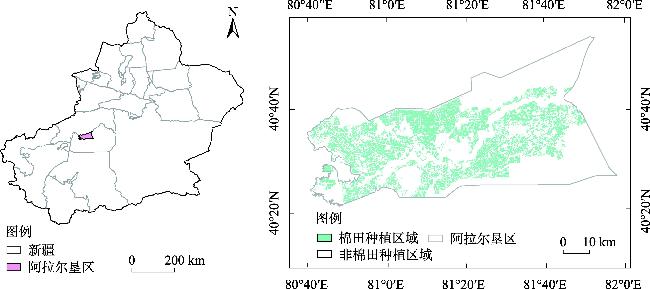
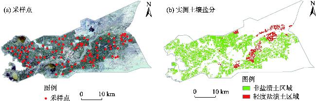
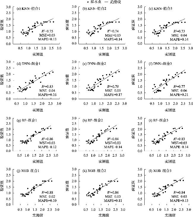
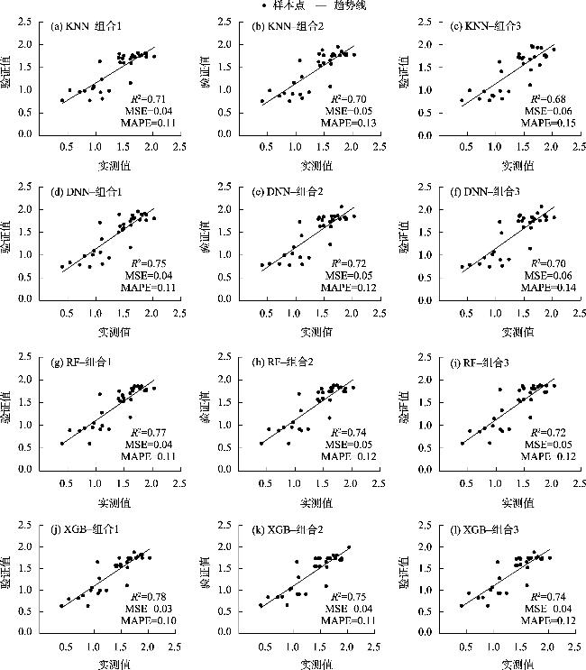
针对新疆土壤盐分信息获取困难,无法快速、准确的大范围评估土壤盐渍化情况,本研究以新疆阿拉尔垦区的棉田为研究对象,利用Sentinel-2 SR和Landsat-9 OLI的多光谱遥感影像数据,采用穷举特征组合和交叉验证方法,从20个光谱指数和组合光谱指数构建的高维数据集中筛选出最优特征子集,并比较四种机器学习模型(即XGBoost、随机森林、深度神经网络和K-近邻)在不同特征组合下的土壤盐渍化反演精度,同时分析Sentinel-2 SR和Landsat-9 OLI遥感影像在土壤盐渍化反演中的精度差异。研究结果表明:(1) 基于XGBoost算法构建的模型能够实现棉田盐渍化高精度预测,不同特征组合的R2均高于0.74,MSE均低于0.04,MAPE低于0.13。(2) 在特征组合1条件下,Sentinel-2 SR(S3+GBNDVI)与Landsat-9 OLI(SI+NDVI)遥感影像使用XGBoost算法均获得了最高预测精度。(3) Sentinel-2 SR影像数据在棉田盐渍化预测中的精度(R2=0.73~0.88)优于Landsat-9 OLI影像数据。本研究实现了新疆阿拉尔垦区棉田土壤盐渍化精准监测,为垦区棉田土壤盐渍化治理和防治提供有效的技术参考。
洪国军 , 谢俊博 , 张灵 , 范振岐 , 喻彩丽 , 付仙兵 , 李旭 . 基于多光谱影像的阿拉尔垦区棉田土壤盐分反演[J]. 干旱区研究, 2024 , 41(5) : 894 -904 . DOI: 10.13866/j.azr.2024.05.16
Given the difficulties in the field measurement of soil salinization in Xinjiang and the difficulty in quickly and broadly evaluating the potential hazards of soil salinization, this study considers cotton fields in the Aral Reclamation Area of Xinjiang as the research object, and uses multispectral remote sensing image data from Sentinel-2 SR and Landsat-9 OLI to construct a high-dimensional data set by comprehensively integrating 20 spectral indices and combining spectral indices. The optimal feature subset is screened using the method of exhaustive feature combination and cross-validation, and the inversion accuracy of soil salinization is compared for four machine learning algorithms (i.e., XGBoost, random forest, deep neural network, and K-nearest neighbor) under different feature combinations. Simultaneously, the difference in accuracy between Sentinel-2 SR and Landsat-9 OLI remote sensing images in soil salinization inversion is analyzed. The results show that: (1) The model constructed based on XGBoost algorithm can achieve high-precision prediction of cotton field salinization, with R2 higher than 0.74, MSE lower than 0.04, and MAPE lower than 0.13. (2) Under the condition of feature combination 1, Sentinel-2 SR (S3+GBNDVI) and Landsat-9 OLI (SI+NDVI) remote sensing images achieved the highest prediction accuracy using XGBoost algorithm. (3) Sentinel-2 SR image data in cotton field salinization prediction (R2=0.73-0.88) is better than that of Landsat-9 OLI image data. This study realizes the precise monitoring of soil salinization in cotton fields in the Aral Reclamation Area of Xinjiang, which should provide an effective and timely technical reference for soil salinization control and prevention in cotton fields in reclamation areas.
表1 光谱指数的表达式Tab. 1 Expression of the spectral index |
| 光谱指数 | 表达式 | 参考文献 |
|---|---|---|
| SI | [15] | |
| SI1 | [16] | |
| SI2 | [17] | |
| SI3 | [18] | |
| S1 | [19] | |
| S2 | [20] | |
| S3 | [19-20] | |
| S5 | [19-20] | |
| CRSI | [19-20] | |
| MSAVI | [21-22] | |
| NDVI | [23⇓⇓⇓⇓⇓⇓-30] | |
| RVI | [26] | |
| DVI | [27] | |
| GNDVI | [27⇓-29] | |
| EVI | [30] | |
| OSAVI | [31] | |
| SAVI | [31-32] | |
| NDWI | [33] | |
| GBNDVI | [34] | |
| GRNDVI | [27] |
注:b2、b3、b4、b8、b11分别为蓝、绿、红、近红外、短波红外波段。 |
表2 模型的组合Tab. 2 Modeling combination |
| 遥感影像 | 特征选择 | 相关性(R2) | 组合 |
|---|---|---|---|
| Sentinel-2 SR | S3, GBNDVI | 0.93 | 组合1 |
| S3, GBNDVI, MSAVI, SI1 | 0.91 | 组合2 | |
| S3, EVI, GBNDVI, MSAVI | 0.90 | 组合3 | |
| Landsat-9 OLI | SI, NDVI | 0.87 | 组合1 |
| SI, SI3, NDVI | 0.85 | 组合2 | |
| SI, NDVI, GRNDVI | 0.84 | 组合3 |
表3 基于Sentinel-2 SR影像不同模型的电导率训练分析Tab. 3 Analysis of conductivity training based on different models of Sentinel-2 SR images |
| 数据源 | 模型 | 机器学习模 型评价指标 | 组合1 | 组合2 | 组合3 |
|---|---|---|---|---|---|
| Sentinel-2 SR | KNN | R2 | 0.80 | 0.78 | 0.78 |
| MSE | 0.04 | 0.04 | 0.04 | ||
| MAPE | 0.15 | 0.16 | 0.16 | ||
| RF | R2 | 0.90 | 0.87 | 0.87 | |
| MSE | 0.02 | 0.02 | 0.03 | ||
| MAPE | 0.10 | 0.10 | 0.11 | ||
| DNN | R2 | 0.85 | 0.84 | 0.82 | |
| MSE | 0.03 | 0.03 | 0.03 | ||
| MAPE | 0.12 | 0.14 | 0.16 | ||
| XGB | R2 | 0.92 | 0.90 | 0.88 | |
| MSE | 0.02 | 0.02 | 0.02 | ||
| MAPE | 0.09 | 0.09 | 0.010 |
表4 基于Landsat-9 OLI影像不同模型的电导率训练分析Tab. 4 Analysis of conductivity training based on different models of Landsat-9 OLI images |
| 数据源 | 模型 | 机器学习模 型评价指标 | 组合1 | 组合2 | 组合3 |
|---|---|---|---|---|---|
| Landsat-9 OLI | KNN | R2 | 0.77 | 0.76 | 0.72 |
| MSE | 0.04 | 0.04 | 0.05 | ||
| MAPE | 0.15 | 0.15 | 0.16 | ||
| RF | R2 | 0.82 | 0.81 | 0.78 | |
| MSE | 0.03 | 0.04 | 0.04 | ||
| MAPE | 0.11 | 0.12 | 0.11 | ||
| DNN | R2 | 0.81 | 0.80 | 0.76 | |
| MSE | 0.04 | 0.04 | 0.05 | ||
| MAPE | 0.14 | 0.15 | 0.16 | ||
| XGB | R2 | 0.85 | 0.84 | 0.82 | |
| MSE | 0.03 | 0.03 | 0.04 | ||
| MAPE | 0.10 | 0.11 | 0.11 |
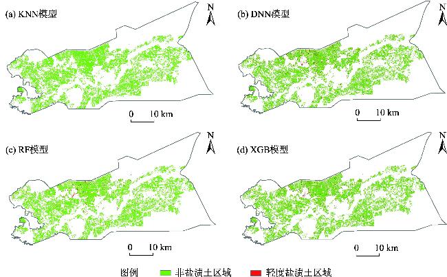
图3 基于Sentinel-2 SR影像不同模型的电导率验证集模型分析Fig. 3 Analysis of conductivity validation set models based on different models of Sentinel-2 SR images |
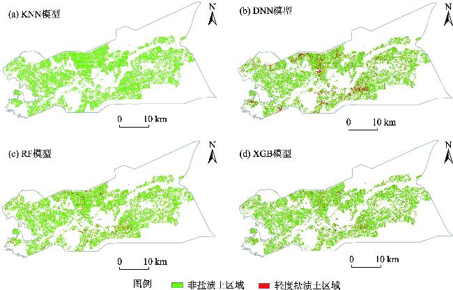
图5 基于Sentinel-2 SR影像不同模型下阿拉尔垦区棉田盐渍化土壤空间反演Fig. 5 Spatial inversion of saline soil in cotton fields of Alar Reclamation Area based on different models of Sentinel-2 SR images |
| [1] |
黄晶, 孔亚丽, 徐青山, 等. 盐渍土壤特征及改良措施研究进展[J]. 土壤, 2022, 54(1): 18-23.
[
|
| [2] |
杨劲松, 姚荣江, 王相平, 等. 中国盐渍土研究: 历程、现状与展望[J]. 土壤学报, 2022, 59(1): 10-27.
[
|
| [3] |
|
| [4] |
|
| [5] |
|
| [6] |
|
| [7] |
|
| [8] |
杜瑞麒, 陈俊英, 张智韬, 等. Sentinel-2 多光谱卫星遥感反演植被覆盖下的土壤盐分变化[J]. 农业工程学报, 2021, 37(17): 107-115.
[
|
| [9] |
|
| [10] |
|
| [11] |
|
| [12] |
|
| [13] |
王遵亲, 祝寿泉, 尤文瑞, 等. 中国盐渍土[M]. 北京: 科学出版社, 1993.
[
|
| [14] |
|
| [15] |
|
| [16] |
陈俊英, 王新涛, 张智韬, 等. 基于无人机-卫星遥感升尺度的土壤盐渍化监测方法[J]. 农业机械学报, 2019, 50(12):161-169.
[
|
| [17] |
刘旭辉, 白云岗, 柴仲平, 等. 基于多光谱遥感的典型绿洲棉田春季土壤盐分反演及验证[J]. 干旱区地理, 2022, 45(4): 1165-1175.
[
|
| [18] |
张术伟, 常春艳, 王卓然, 等. 基于卫星遥感的黄三角濒海区土壤水盐及其耦合关系时空分析[J]. 农业资源与环境学报, 2023, 40(4): 792-804.
[
|
| [19] |
冯娟, 丁建丽, 杨爱霞, 等. 干旱区土壤盐渍化信息遥感建模[J]. 干旱地区农业研究, 2018, 36(1): 266-273.
[
|
| [20] |
黄晓宇, 王雪梅, 卡吾恰提·白山. 基于Landsat8 OLI影像干旱区绿洲土壤含盐量反演[J]. 自然资源遥感, 2023, 35(1): 189-197.
[
|
| [21] |
姚金玺, 肖成志, 张志, 等. 基于GEE多源遥感数据的干旱区植被地物类型提取[J]. 干旱区研究, 2024, 41(1): 157-168.
[
|
| [22] |
|
| [23] |
代云豪, 管瑶, 张钦凯, 等. 阿拉尔垦区土壤盐渍化遥感监测及时空特征分析[J]. 干旱区地理, 2022, 45(4): 1176-1185.
[
|
| [24] |
马浩文, 王永芳, 郭恩亮. 基于GEE的翁牛特旗土地沙漠化遥感监测[J]. 干旱区研究, 2023, 40(3): 504-516.
[
|
| [25] |
谢俊博, 王兴鹏, 何帅, 等. 基于光谱指数建模的沙井子灌区土壤盐分反演[J]. 干旱区地理, [2024-02-05]. http://kns.cnki.net/kcms/detail/65.1103.X.20240202.1806.002.html.
[
|
| [26] |
|
| [27] |
|
| [28] |
|
| [29] |
朱大运, 熊康宁, 肖华, 等. 基于植被指数的GF-1与Landsat-OLI石漠化识别能力对比评价[J]. 自然资源学报, 2016, 31(11): 1949-1957.
[
|
| [30] |
|
| [31] |
李小雨, 贾科利, 魏慧敏, 等. 基于随机森林算法的土壤含盐量预测[J]. 干旱区研究, 2023, 40(8): 1258-1267.
[
|
| [32] |
李霞, 刘廷玺, 段利民, 等. 半干旱区沙丘、草甸作物系数模拟及蒸散发估算[J]. 干旱区研究, 2020, 37(5):1246-1255.
[
|
| [33] |
|
| [34] |
|
| [35] |
|
| [36] |
|
/
| 〈 |
|
〉 |