
马莲河下游产水量时空演变特征
|
高雅玉(1985-),女,正高级工程师,博士,主要从事水资源与水土保持方面的研究工作. E-mail: gyy@lut.edu.cn |
收稿日期: 2023-12-13
修回日期: 2024-01-30
网络出版日期: 2024-06-20
基金资助
甘肃省重点研发计划项目(22YF7FA165)
高端外国专家引进计划项目(22JR10KA006)
甘肃省水利科学试验研究及推广计划项目(22GSLK006)
甘肃省水利科学试验研究及推广计划项目(22GSLK011)
甘肃省水利科学试验研究及推广计划项目(23GSLK007)
甘肃省水利科学试验研究及推广计划项目(24GSLK074)
Spatiotemporal evolution of water yield in the lower Malian River Basin
Received date: 2023-12-13
Revised date: 2024-01-30
Online published: 2024-06-20
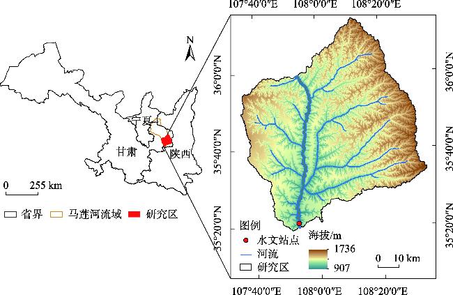
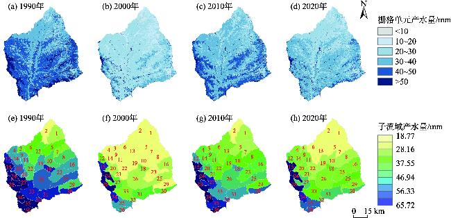
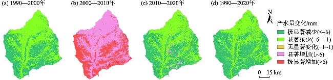
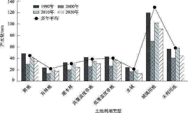
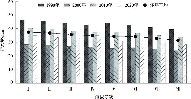
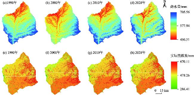
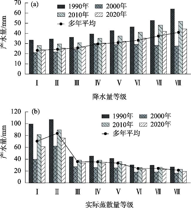
马莲河下游流域是我国陇东典型的黄土高原沟壑区,在气候和土地利用变化背景下研究其产水量的时空特征和变化响应,对区域生态系统可持续发展具有重要意义。基于InVEST (Integrated Valuation of Ecosystem Services and Trade-offs)模型定量评估1990年、2000年、2010年和2020年4个时期马莲河下游流域产水量的时空格局和变化,运用地理探测器分析影响因子对产水功能空间分异的影响程度。结果表明:(1) 1990—2020年,马莲河下游流域总产水量整体呈现先减后增再减的变化趋势,2020年总产水量相比1990年减少了5.9×10⁷ m3,减少率为25.43%。不同时期产水量在空间上呈现南部和边缘地带高、北部和中心地带低的分布特征。(2) 不同土地利用类型产水能力大小排序依次为:城镇用地>未利用地>耕地>低覆盖度草地>高覆盖度草地>灌木林>有林地>水域。(3) 产水量与降水量呈现明显的正相关,与实际蒸散发量和海拔之间存在负相关。降水和实际蒸散发是决定产水量空间分布和变化的主导因素,q值分别为0.616~0.735和0.517~0.653。研究成果可为陇东黄土高原沟壑区水土资源开发、利用和管理提供科学支撑。
高雅玉 , 宋玉 , 赵廷红 , 高金芳 , 何文博 , 李泽霞 . 马莲河下游产水量时空演变特征[J]. 干旱区研究, 2024 , 41(5) : 776 -787 . DOI: 10.13866/j.azr.2024.05.06
This study examines water yield patterns in the lower reaches of the Malian River Basin, which are typical loess plateau gully areas in eastern Gansu Province, China. These areas are crucial for regional ecosystem health and understanding the temporal and spatial characteristics and response of water yield considering climate and land-use changes. Employing the Integrated Valuation of Ecosystem Services and Trade-offs (InVEST) model, we quantitatively assess the spatial and temporal patterns of water yields across four years: 1990, 2000, 2010, and 2020. Spatial heterogeneity in water yield across the lower reaches of the Malian River Basin was assessed using geographic detection techniques. Analysis revealed a fluctuating trend in total water yield from 1990 to 2020, characterized by an initial decrease, followed by an increase, and finally another decrease. Compared to 1990, total water yield in 2020 declined by 5.9×10⁷ m3 (25.43% reduction). Furthermore, spatial analysis revealed a distinct pattern in water yield distribution across the basin. Higher water yield was observed in the southern and marginal areas, whereas lower yield characterized the northern and central regions. Land-use type significantly influenced water yield capacity. Ranked from highest to lowest, the order was as follows: construction land>bare land>agricultural land>low-coverage grassland>high-coverage grassland>shrub land>forest land>open water. Moreover, a significant positive correlation was identified between water yield and precipitation, suggesting that precipitation plays a key role in water production. Conversely, a negative correlation emerged between actual evapotranspiration and altitude. Our analysis identified precipitation and actual evapotranspiration as the primary drivers of spatial variations and temporal changes in water yield, with q values ranging from 0.616 to 0.735 and 0.517 to 0.653, respectively. These findings provide valuable scientific evidence to support the development, utilization, and management of soil and water resources in the loess plateau of eastern Gansu.
表1 生物物理系数Tab. 1 Biophysical coefficient |
| 土地利用编号 | 土地利用 类型 | 植被蒸散系数 | 植物最大根系深度/mm | 属性类别 |
|---|---|---|---|---|
| 1 | 耕地 | 0.65 | 400 | 1 |
| 2 | 有林地 | 0.95 | 3000 | 1 |
| 3 | 灌木林 | 0.9 | 2500 | 1 |
| 4 | 高覆盖度草地 | 0.65 | 500 | 1 |
| 5 | 低覆盖度草地 | 0.6 | 450 | 1 |
| 6 | 水域 | 0.9 | 1 | 0 |
| 7 | 城镇用地 | 0.3 | 1 | 0 |
| 8 | 未利用地 | 0.5 | 100 | 0 |
注:属性类别是根据是否有植被覆盖来判定0和1,植被覆盖地类(不包括湿地)赋值为1,其他土地利用类型(包括湿地、城市用地、水体、永久冰雪等)赋值为0。 |
表2 1990—2020年马莲河下游流域模拟产水量与实测径流量Tab. 2 Simulated water yield and measured runoff of the lower Malian River Basin from 1990 to 2020 |
| 年份 | ||||
|---|---|---|---|---|
| 1990年 | 2000年 | 2010年 | 2020年 | |
| 实测径流量/mm | 42.71 | 25.68 | 36.01 | 31.76 |
| 模拟产水量/mm | 43.29 | 26.66 | 37.52 | 32.31 |
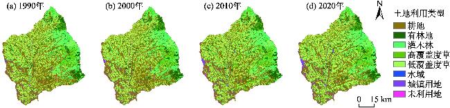
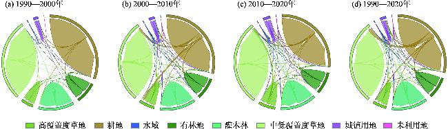
表3 土地利用类型面积统计Tab. 3 Land use type and area statistics |
| 土地利用 类型 | 1990—2000年 | 2000—2010年 | 2010—2020年 | 1990—2020年 | |||||||
|---|---|---|---|---|---|---|---|---|---|---|---|
| 面积变化/km2 | 变化率/% | 面积变化/km2 | 变化率/% | 面积变化/km2 | 变化率/% | 面积变化/km2 | 变化率/% | ||||
| 耕地 | -10.39 | -0.53 | -226.47 | -11.65 | -32.5 | -1.89 | -269.36 | -13.79 | |||
| 有林地 | 1.07 | 0.23 | 17.14 | 3.72 | -0.39 | -0.08 | 17.82 | 3.88 | |||
| 灌木林 | 0.16 | 0.02 | 4.87 | 0.63 | 1.68 | 0.22 | 6.71 | 0.87 | |||
| 高覆盖度草地 | 0.12 | 0.04 | 137.95 | 51.27 | -85.56 | -21.02 | 52.51 | 19.52 | |||
| 低覆盖度草地 | -0.06 | 0.01 | 31.08 | 1.74 | 92.39 | 5.09 | 123.41 | 6.91 | |||
| 水域 | -0.89 | -7.21 | -0.9 | -7.86 | 0.12 | 1.14 | -1.67 | -13.53 | |||
| 城镇用地 | 9.16 | 9.02 | 33.93 | 30.64 | 19.29 | 13.33 | 62.38 | 61.41 | |||
| 未利用地 | 0.78 | 0.39 | 0.4 | 0.14 | 0.93 | 0.29 | 2.11 | 1.07 | |||
表4 1990—2020年马莲河下游流域各类因子对产水量空间分布的解释力Tab. 4 Explanatory power of various factors on spatial distribution of water yield in the lower Malian River Basin from 1990 to 2020 |
| 年份 | 降水 | 实际蒸散发 | 海拔 | 土地利用类型 |
|---|---|---|---|---|
| 1990年 | 0.616 | 0.517 | 0.344 | 0.196 |
| 2000年 | 0.722 | 0.653 | 0.370 | 0.135 |
| 2010年 | 0.714 | 0.618 | 0.367 | 0.135 |
| 2020年 | 0.735 | 0.625 | 0.376 | 0.114 |
| [1] |
|
| [2] |
|
| [3] |
戴尔阜, 王晓莉, 朱建佳, 等. 生态系统服务权衡/协同研究进展与趋势展望[J]. 地球科学进展, 2015, 30(11): 1250-1259.
[
|
| [4] |
|
| [5] |
|
| [6] |
孙琪, 徐长春, 任正良, 等. 塔里木河流域产水量时空分布及驱动因素分析[J]. 灌溉排水学报, 2021, 40(8): 114-122.
[
|
| [7] |
吴健, 李英花, 黄利亚, 等. 东北地区产水量时空分布格局及其驱动因素[J]. 生态学杂志, 2017, 36(11): 3216-3223.
[
|
| [8] |
|
| [9] |
|
| [10] |
|
| [11] |
赵美亮, 曹广超, 赵青林, 等. 气候及土地利用变化对大通河源区水文要素空间分布的影响[J]. 干旱区研究, 2023, 40(3): 381-391.
[
|
| [12] |
刘斯文, 刘海隆, 王玲. MIKE SHE模型的发展与应用研究[J]. 水文, 2018, 38(5): 23-28.
[
|
| [13] |
|
| [14] |
雷馨, 海新权. 祁连山地区土地利用变化对碳储量的影响及经济价值估算[J]. 干旱区研究, 2023, 40(11): 1845-1854.
[
|
| [15] |
|
| [16] |
|
| [17] |
|
| [18] |
包玉斌, 李婷, 柳辉, 等. 基于InVEST模型的陕北黄土高原水源涵养功能时空变化[J]. 地理研究, 2016, 35(4): 664-676.
[
|
| [19] |
刘宥延, 刘兴元, 张博, 等. 基于InVEST模型的黄土高原丘陵区水源涵养功能空间特征分析[J]. 生态学报, 2020, 40(17): 6161-6170.
[
|
| [20] |
王雨山, 程旭学, 张梦南. 马莲河流域河水化学特征和化学风化过程分析[J]. 地球与环境, 2018, 46(1): 15-22.
[
|
| [21] |
彭世想, 郭相秦, 刘卓, 等. 马莲河流域水沙变化与水土保持成效分析[J]. 中国水土保持, 2020 (11): 29-31, 48.
[
|
| [22] |
龚诗涵, 肖洋, 郑华, 等. 中国生态系统水源涵养空间特征及其影响因素[J]. 生态学报, 2017, 37(7): 2455-2462.
[
|
| [23] |
|
| [24] |
|
| [25] |
周文佐. 基于GIS的我国主要土壤类型土壤有效含水量研究[D]. 南京: 南京农业大学, 2003.
[
|
| [26] |
王劲峰, 徐成东. 地理探测器: 原理与展望[J]. 地理学报, 2017, 72(1): 116-134.
[
|
| [27] |
|
| [28] |
郑续, 魏乐民, 郭建军, 等. 基于地理探测器的干旱区内陆河流域产水量驱动力分析——以疏勒河流域为例[J]. 干旱区地理, 2020, 43(6): 1477-1485.
[
|
| [29] |
郭倩. 全球气候变化背景下土地利用和流域水生态系统响应研究[D]. 兰州: 兰州大学, 2022.
[
|
| [30] |
杨洁, 谢保鹏, 张德罡. 基于InVEST模型的黄河流域产水量时空变化及其对降水和土地利用变化的响应[J]. 应用生态学报, 2020, 31(8): 2731-2739.
[
|
| [31] |
赖明, 陈仁升, 刘玖芬, 等. 雅鲁藏布江下游产水量时空演变及对气候和土地利用变化的响应[J]. 草业科学, 2022, 39(12): 2516-2526.
[
|
| [32] |
刘美娟, 仲俊涛, 王蓓, 等. 基于InVEST模型的青海湖流域产水功能时空变化及驱动因素分析[J]. 地理科学, 2023, 43(3): 411-422.
[
|
| [33] |
董玉婷, 穆兴民, 王双银, 等. 产流及其研究进展[J]. 华北水利水电大学学报(自然科学版), 2022, 43(2): 21-29.
[
|
/
| 〈 |
|
〉 |