
Comprehensive evaluation of sand hazards on the Yuli-Qiemo desert highway based on the variable weight-cloud model theory
Received date: 2025-01-15
Revised date: 2025-05-12
Online published: 2026-03-11
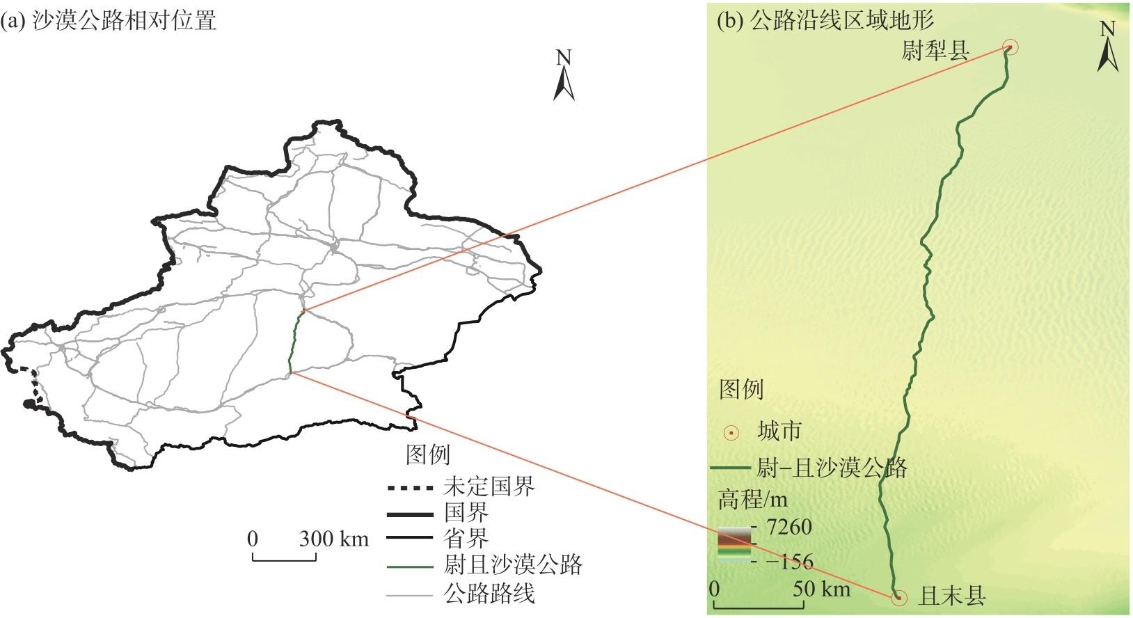
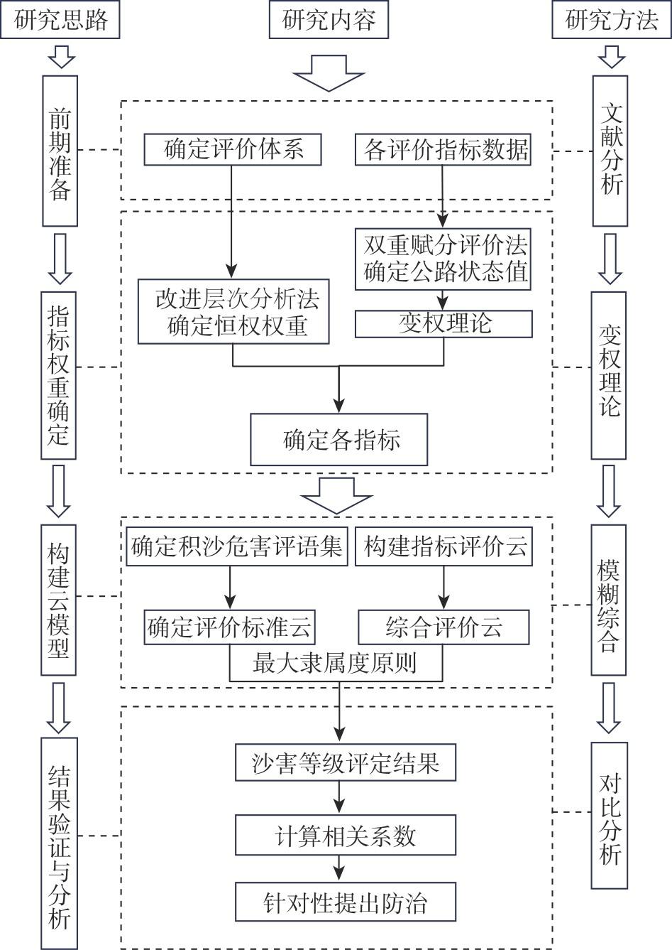
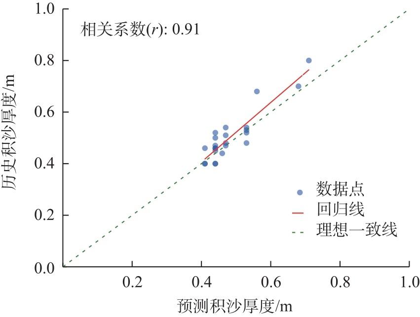
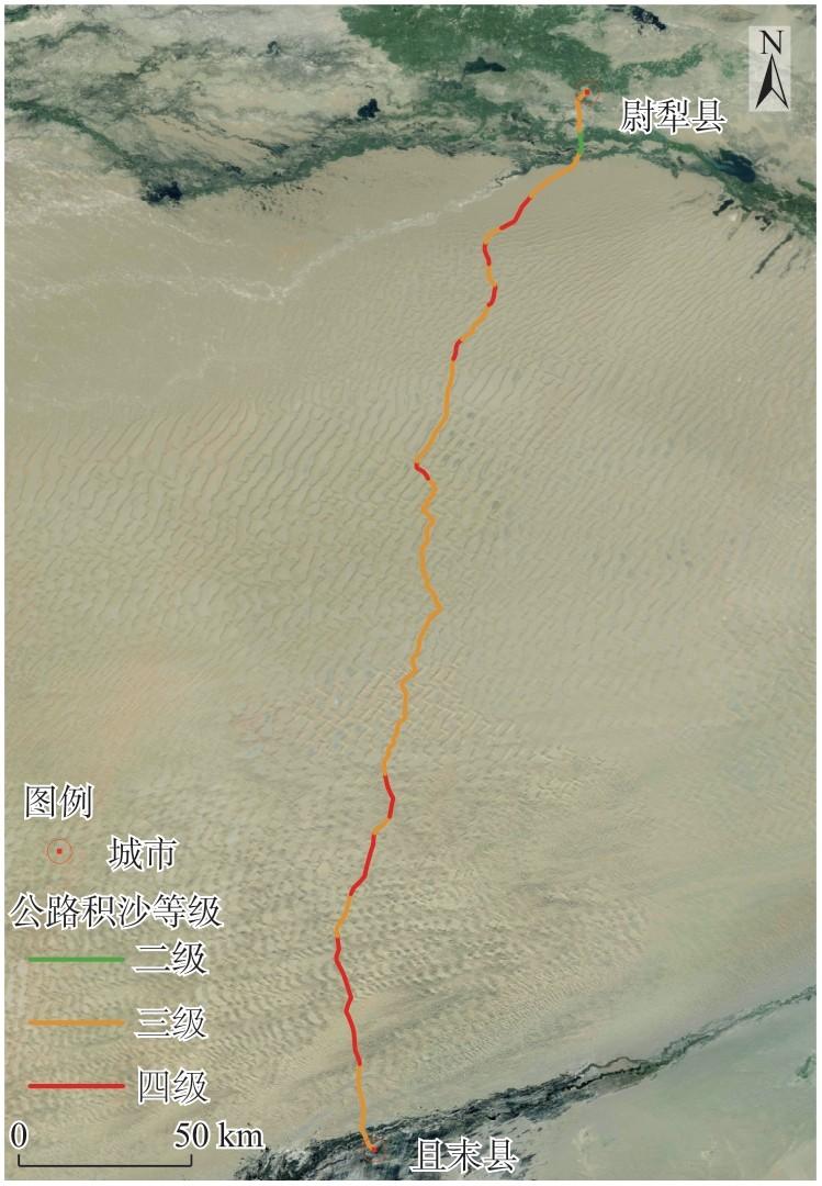
Assessing aeolian sand hazards is fundamental to the construction, operation, and maintenance of desert highways. However, conventional evaluation methods often suffer from excessive subjectivity, highlighting the need for an objective and robust assessment framework. Focusing on the Yuli-Qiemo desert highway in China, this study proposes a novel, data-driven method for evaluating aeolian sand-hazard risks, based on extensive field investigations conducted in 2023 and analyses. First, a variable-weight cloud model was established, incorporating ten key indicators. A modified analytic hierarchy was used to determine the indicator fixed weights. Second, a dual-score evaluation method, integrated with computational algorithms, enabled automated batch processing of indicator stratification and dynamic weight adjustment based on variable-weight theory. Third, the variable-weight cloud model was used to classify hazard levels, which were validated against historical sand hazard records. The results indicate that (1) The proposed method enables efficient and accurate assessment of aeolian sand hazards along entire highways, transitioning from isolated segment evaluation to full-route analysis. This is achieved through the automated computation of state values and real-time adjustment of indicator weights. (2) Comparison with historical sand hazard records yielded a correlation coefficient of 0.91 (P<0.001), indicating a significant positive correlation within the 95% confidence interval and demonstrating the method’s ability to reduce human subjectivity. (3) The overall aeolian sand-hazard risk of the Yuli-Qiemo desert highway is high. Grade III hazard segments dominate (65.46%), followed by grade IV (30.91%), with no segments classified as grade I. The risk is low at the northern and southern ends of the highway, high in the middle segments, and gradually increases in severity from north to south. Middle segments K180-K250 and K30-K60 are the most severely affected and warrant prioritized mitigation efforts. This novel method for identifying and predicting aeolian sand hazard risks along desert highways offers critical insights to inform targeted prevention and control strategies.
Mingkun LYU , Chunmei LIU , Xiangjun YANG , Yuan LING , Shengyu LI , Zhentao LYU . Comprehensive evaluation of sand hazards on the Yuli-Qiemo desert highway based on the variable weight-cloud model theory[J]. Arid Land Geography, 2026 , 49(1) : 69 -79 . DOI: 10.12118/j.issn.1000-6060.2025.031
表1 沙漠公路积沙灾害评价体系Tab. 1 Evaluation system of sand accumulation hazards on desert highways |
| 评价目标 | 一级指标 | 二级指标 | 指标性质 | 恒权权重 |
|---|---|---|---|---|
| 沙漠公路沙 害综合评价 | 区域地貌条件 | 流动沙丘高度/m | 定量 | 0.213 |
| 下垫面形态 | 定性 | 0.050 | ||
| 沿线沙源分布/% | 定性 | 0.117 | ||
| 工程设计因素 | 路基高度/m | 定量 | 0.083 | |
| 迎风弯凹凸面 | 定性 | 0.028 | ||
| 坡率 | 定量 | 0.073 | ||
| 曲线半径/m | 定量 | 0.035 | ||
| 区域风动力 条件 | 输沙势/VU | 定量 | 0.202 | |
| 起沙风频率/% | 定量 | 0.148 | ||
| 路风夹角/(°) | 定量 | 0.050 |
表2 各评价指标评分标准Tab. 2 Classification of levels for each evaluation indicator |
| 评价指标 | 指标分级 | |||
|---|---|---|---|---|
| Ⅰ | Ⅱ | Ⅲ | Ⅳ | |
| 流动沙丘高度/m | <1 | 1~3 | 3~5 | >5 |
| 下垫面形态 | 草方格 | 石方格 | 砾石 | 自然表面 |
| 沿线沙源分布 | 分布有胡杨、红柳包、芦苇 等植物,分布的淤土地、平 沙地和稀疏沙丘疏密度 为20%~40%,且有盐土、草 甸土和龟裂性土分布 | 分布有红柳、沙拐枣等植 物,分布的稀疏沙丘疏密 度为20%~40%;或无植被 分布的沙丘及沙丘链,其疏 密度小于60%;或无植被分 布的平沙地,有残余盐土、半 固定风沙土和粗沙平地分布 | 分布有红柳、沙拐枣等植 被,分布的沙丘及沙丘链疏 密度为60%~80%;或无植 被分布的稀疏沙丘,其疏密 度为40%~60%,大部分为 风沙土 | 无植被分布,分布的高大密 集的沙丘及沙丘链,其疏密 度为80%~100%,全部为风 沙土 |
| 起沙风频率/% | <5 | 5~15 | 15~35 | >35 |
| 输沙势/VU | <200 | 200~300 | 300~400 | >400 |
| 路基高度/m | 1~2 | 2~3 | 3~4 | 4~5 |
| 坡率 | 1:1~1:2 | 1:2~1:3 | 1:3~1:4 | 1:4~1:5 |
| 路风夹角/(°) | 0~15 | 15~45 | 45~75 | 75~90 |
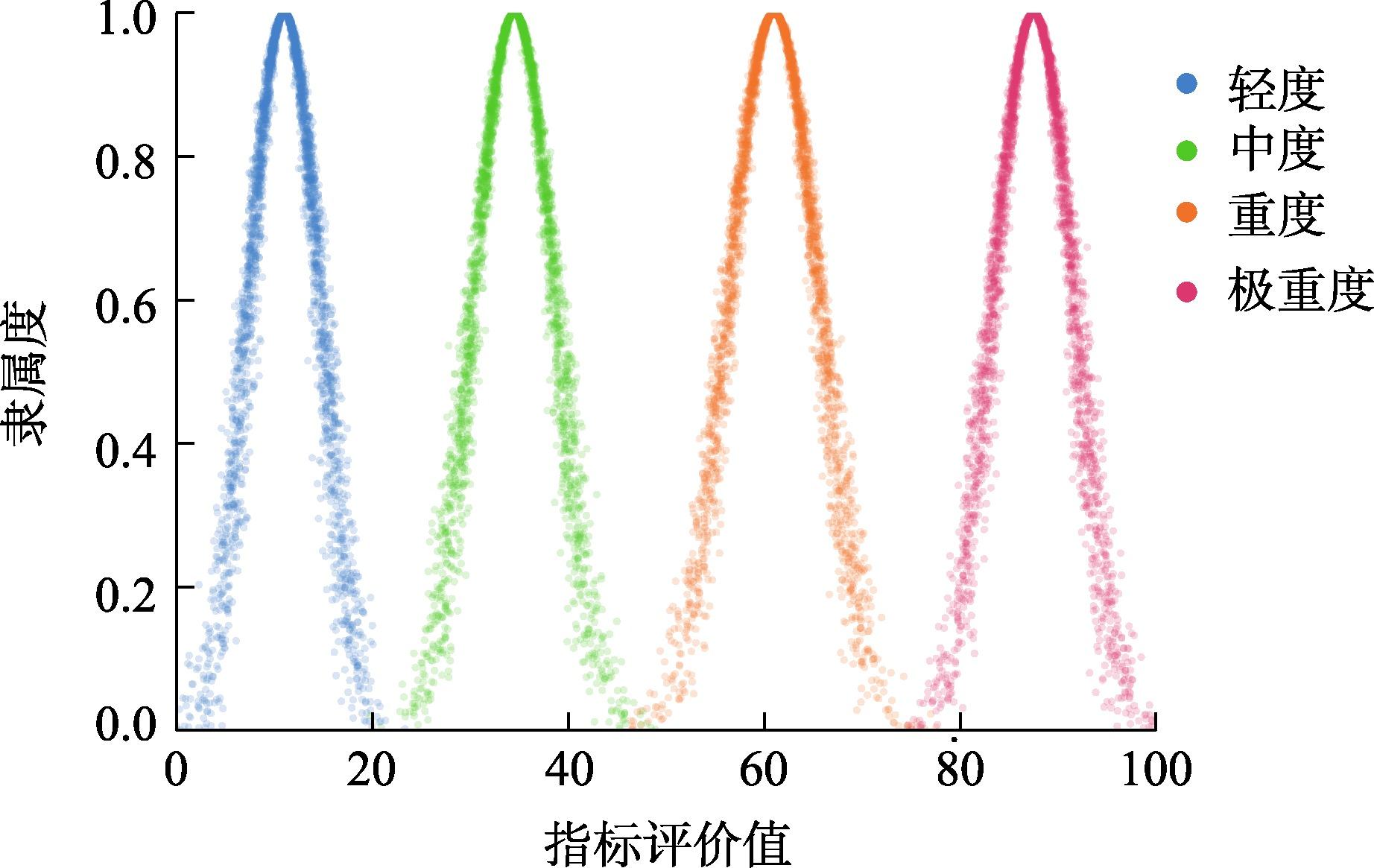
表3 公路积沙程度评语集Tab. 3 Standardized lexicon for the degree of sand accumulation on highways |
| 公路沙害等级 | 路面积沙厚度/cm | 评分区间 |
|---|---|---|
| 轻度(一级) | ≤5 | 0~25 |
| 中度(二级) | 5~20 | 25~50 |
| 重度(三级) | 20~50 | 50~75 |
| 极重度(四级) | ≥50 | 75~100 |
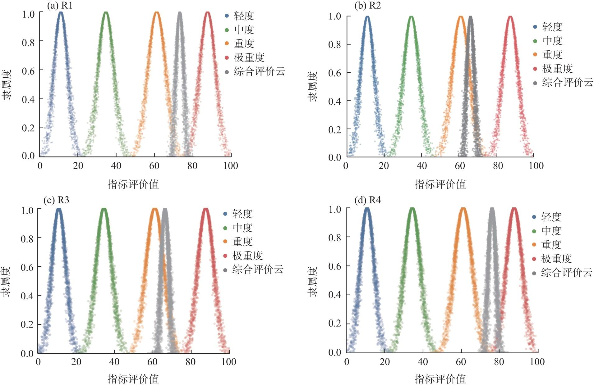
表4 R1、R2、R3、R4路段状态值Tab. 4 State values of road sections R1, R2, R3, and R4 |
| 评价指标 | 状态值 | |||
|---|---|---|---|---|
| R1 | R2 | R3 | R4 | |
| 移动沙丘高度 | 98.91 | 99.46 | 99.28 | 97.63 |
| 下垫面形态 | 24.01 | 23.38 | 26.07 | 25.79 |
| 沿线沙源分布 | 26.76 | 55.13 | 62.50 | 98.91 |
| 路基高度 | 34.49 | 33.72 | 33.61 | 34.86 |
| 迎风弯凹凸面 | 74.21 | 66.40 | 34.45 | 32.81 |
| 坡率 | 30.11 | 28.61 | 28.71 | 30.37 |
| 曲线半径 | 34.37 | 10.51 | 1.65 | 9.26 |
| 输沙势 | 24.90 | 31.58 | 35.86 | 48.89 |
| 起沙风频率 | 33.17 | 37.98 | 40.48 | 50.48 |
| 路风夹角 | 28.57 | 25.19 | 13.47 | 8.12 |
注:R1、R2、R3、R4路段分别为尉-且沙漠公路K65~K70、K90~K95、K120~K125、K195~K200的典型案例路段,用于解释整体评价过程及不同条件下公路风沙灾害的差异化特征。下同。 |
表5 R1、R2、R3、R4路段变权值Tab. 5 Variable weights of road sections R1, R2, R3, and R4 |
| 评价指标 | 恒权权重 | 变权权重 | |||
|---|---|---|---|---|---|
| R1 | R2 | R3 | R4 | ||
| 移动沙丘高度 | 0.213 | 0.466 | 0.431 | 0.426 | 0.360 |
| 下垫面形态 | 0.050 | 0.027 | 0.024 | 0.026 | 0.022 |
| 沿线沙源分布 | 0.117 | 0.070 | 0.131 | 0.148 | 0.201 |
| 路基高度 | 0.083 | 0.063 | 0.057 | 0.056 | 0.050 |
| 迎风弯凹凸面 | 0.028 | 0.047 | 0.039 | 0.020 | 0.016 |
| 坡率 | 0.073 | 0.049 | 0.043 | 0.043 | 0.039 |
| 曲线半径 | 0.035 | 0.027 | 0.008 | 0.001 | 0.006 |
| 输沙势 | 0.202 | 0.112 | 0.130 | 0.146 | 0.171 |
| 起沙风频率 | 0.148 | 0.109 | 0.114 | 0.121 | 0.129 |
| 路风夹角 | 0.050 | 0.032 | 0.026 | 0.014 | 0.007 |
表6 公路积沙灾害标准评价云特征值Tab. 6 Characteristic values of the standard evaluation cloud for sand accumulation hazards on highways |
| 公路沙害等级 | 评价区间 | |||
|---|---|---|---|---|
| 轻度 | 0~25 | 12.5 | 4.167 | 0.417 |
| 中度 | 25~50 | 37.5 | 4.167 | 0.417 |
| 重度 | 50~75 | 62.5 | 4.167 | 0.417 |
| 极重度 | 75~100 | 87.5 | 4.167 | 0.417 |
注: 为第k个分数区间的数学期望值; 为第k个分数区间的熵; 为第k个分数区间的超熵。 |
表7 公路积沙灾害综合评价云特征值Tab. 7 Characteristic values of the comprehensive evaluation cloud for sand accumulation hazards on highways |
| 路段 | Ex | En | He |
|---|---|---|---|
| R1 | 73.674 | 2.018 | 0.521 |
| R2 | 66.206 | 2.204 | 0.674 |
| R3 | 66.329 | 2.358 | 0.563 |
| R4 | 75.320 | 1.992 | 0.636 |
注: 为综合评价云的期望值; 为综合评价云的熵; 为综合评价云的超熵。 |
| [1] |
高蓓蓓, 王世杰. 区域公路网与经济发展空间依赖关系研究[J]. 公路, 2021, 66(8): 235-240.
[
|
| [2] |
李鑫, 艾力·斯木吐拉, 陈正奇, 等. 沙漠公路交通事故特征及成因分析[J]. 长沙交通学院学报, 2006(2): 51-55.
[
|
| [3] |
慕石雷, 杨玉欢, 乌日陶克套胡. 国家沙漠(石漠)公园空间分异格局与影响因素[J]. 干旱区地理, 2024, 47(2): 356-368.
[
|
| [4] |
邢立文, 赵景峰, 何清, 等. 塔克拉玛干沙漠南缘戈壁下垫面辐射平衡与地表反照率特征[J]. 干旱区地理, 2024, 47(5): 762-772.
[
|
| [5] |
费跃, 张强. 基于层次变权的步行系统评价方法优化研究[J]. 交通工程, 2023, 23(3): 9-13.
[
|
| [6] |
|
| [7] |
|
| [8] |
|
| [9] |
|
| [10] |
马奔腾, 程建军, 雷加强, 等. 南疆塔中-38团沙漠公路沿线风沙输移规律与防沙体系研究[J]. 干旱区研究, 2022, 39(5): 1663-1672.
[
|
| [11] |
郑智鹏, 马奔腾, 程建军, 等. 尉犁-且末沙漠公路沿线风沙环境特征及沙害防治对策研究[J]. 干旱区地理, 2023, 46(10): 1680-1691.
[
|
| [12] |
|
| [13] |
王玉竹, 闫浩文, 王小平, 等. 基于GIS的兰新铁路沿线风沙灾害致灾成因分析及评价[J]. 铁道标准设计, 2020, 64(2): 51-56.
[
|
| [14] |
朱震达, 吴正, 李钜章, 等. 塔克拉玛干沙漠风沙地貌研究[J]. 科学通报, 1966, 11(13): 620-624.
[
|
| [15] |
王海宝. 基于云理论的秦皇岛港通航安全评价研究[D]. 大连: 大连海事大学, 2016.
[
|
| [16] |
汪培庄. 模糊集与随机集落影[M]. 北京: 北京师范大学出版社, 1985: 11-12.
[
|
| [17] |
程磊, 史浩镕, 贺智勇, 等. 基于变权-云模型的煤矿安全生产评价研究[J]. 河南理工大学学报(自然科学版), 2024, 43(5): 10-18.
[
|
| [18] |
|
| [19] |
杨晨, 张建华. 基于组合赋权灰色模糊理论的边坡地震稳定性研究[J]. 工业建筑, 2014, 44(增刊1): 878-881, 877.
[
|
| [20] |
崔天宝. 基于云模型的短期电价预测的研究[D]. 北京: 华北电力大学, 2008.
[
|
| [21] |
|
/
| 〈 |
|
〉 |