
Regional differences and threshold of ecological base flow in the Qinling Mountains-Loess Plateau region
Received date: 2024-03-18
Revised date: 2024-06-04
Online published: 2026-03-11
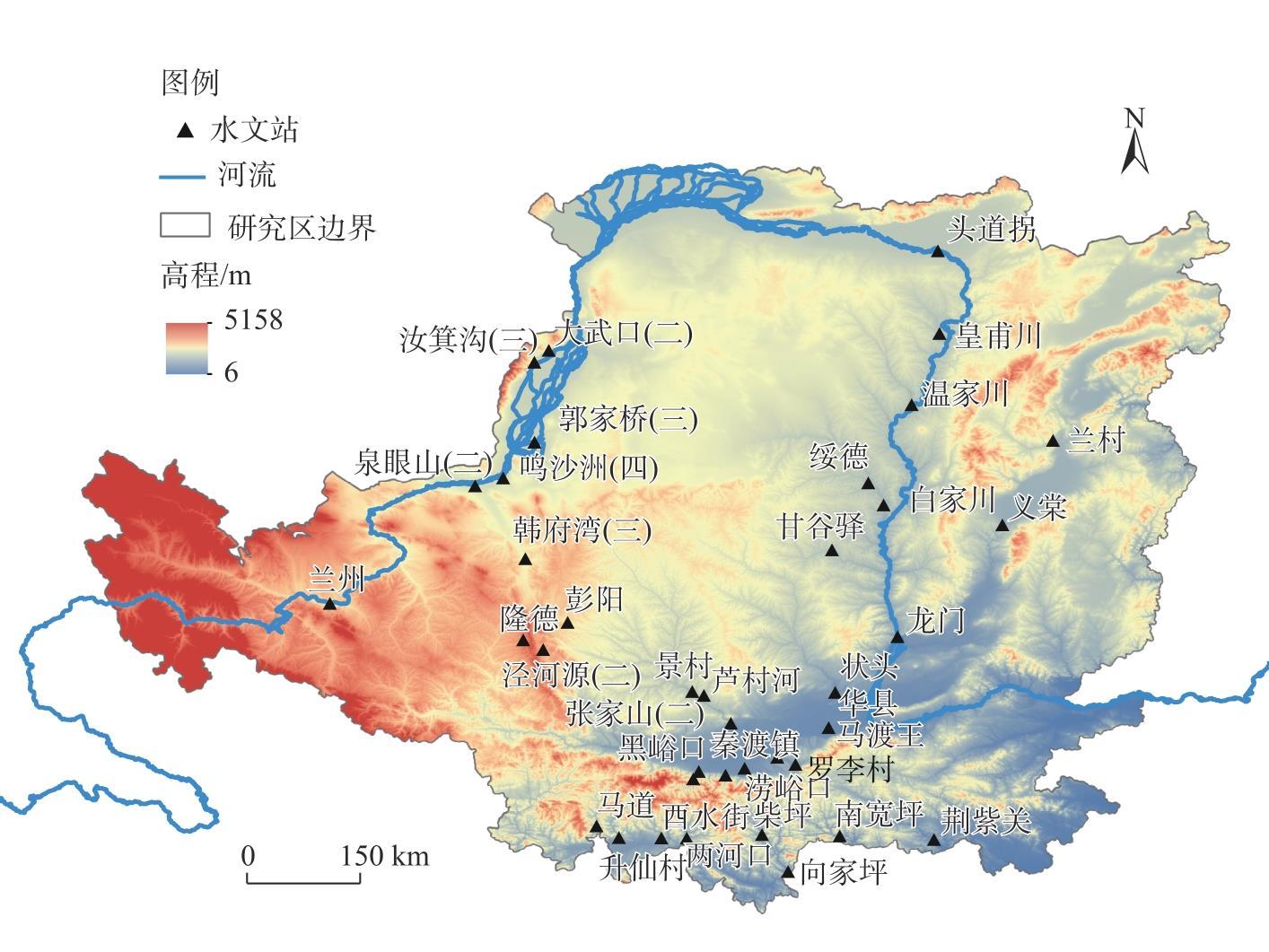
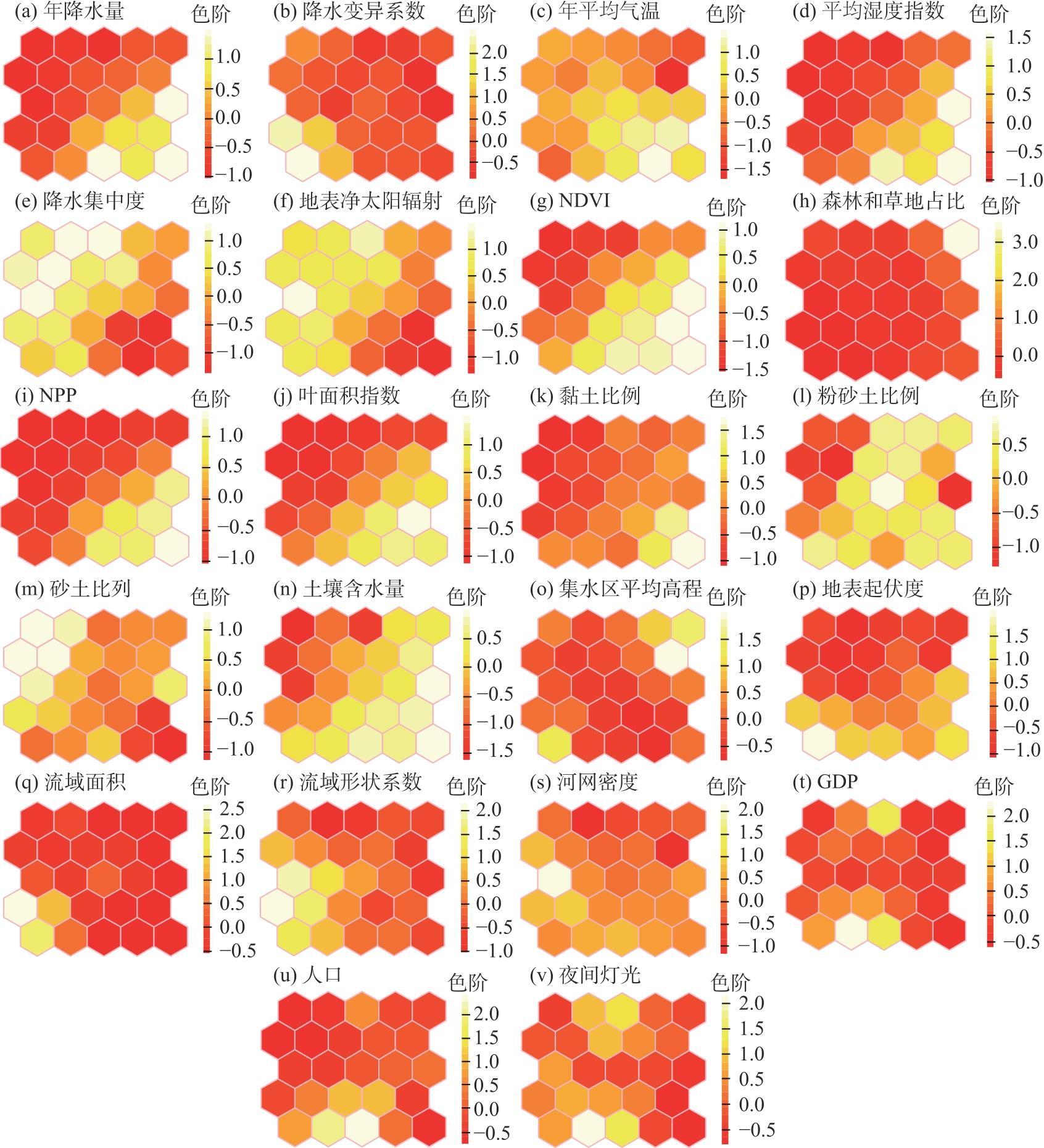
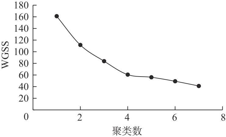
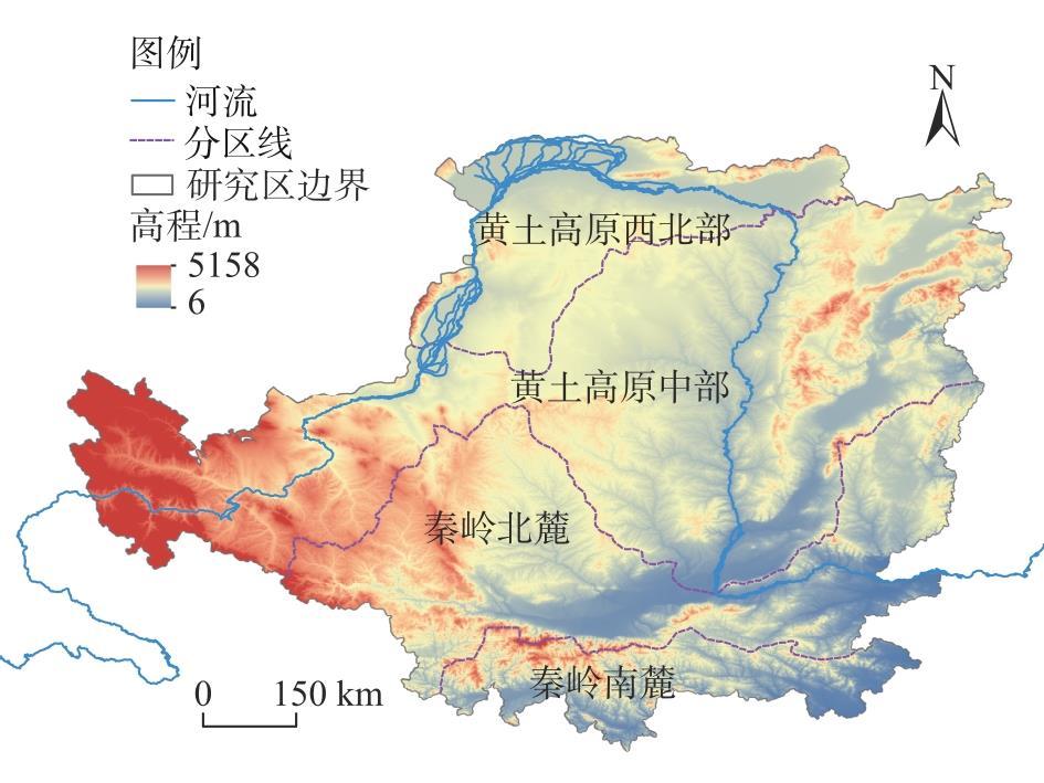
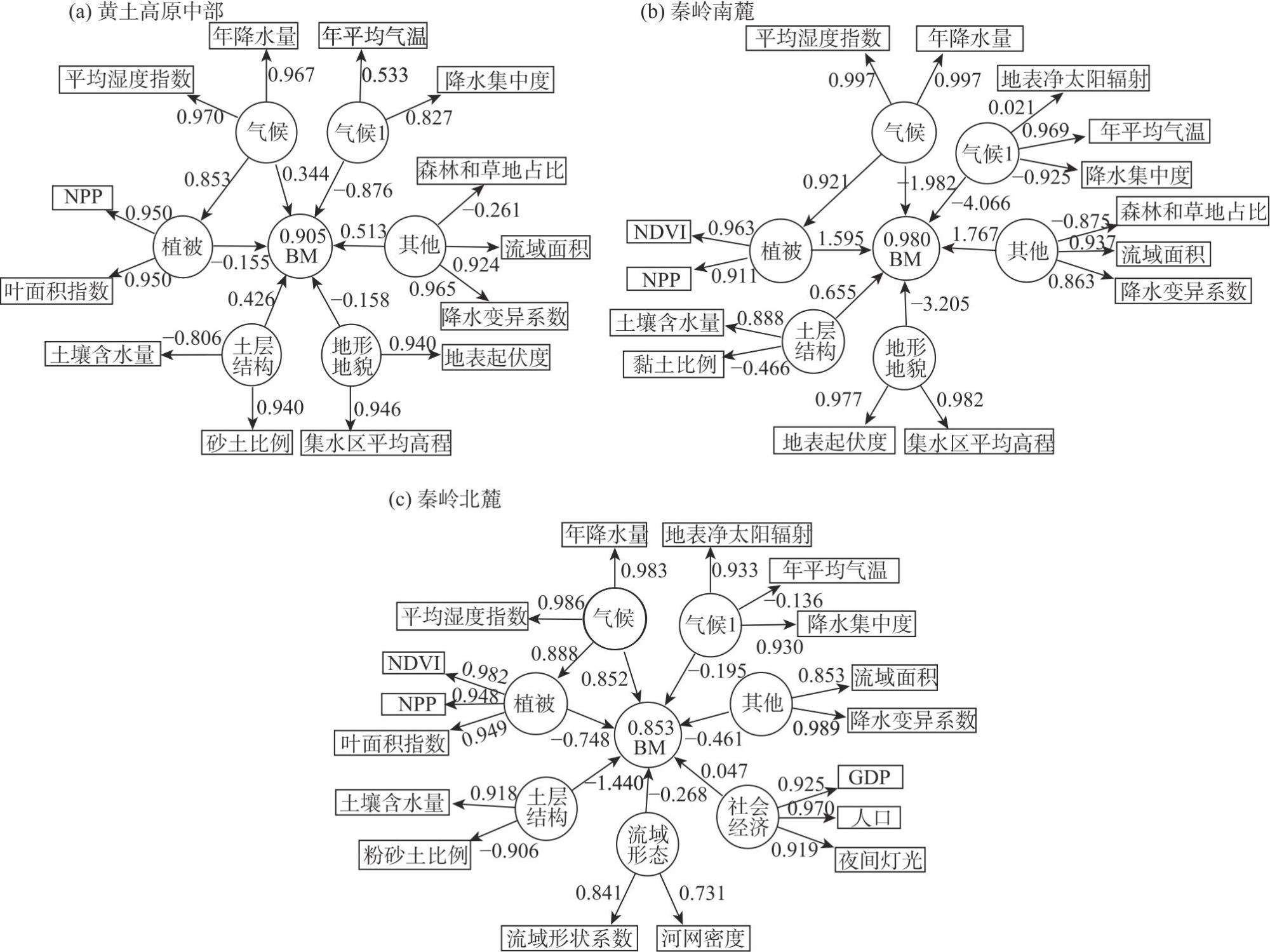
The Qinling Mountains-Loess Plateau geological and geomorphological continuum features a fragile ecosystem where river ecological base flow and its thresholds are critical for ecosystem protection. This study examines the Qinling Mountains-Loess Plateau region in China, constructing a system of 22 ecological base flow influencing factors, including climate, vegetation, topography, soil structure, watershed morphology, and socio-economic variables. Using a self-organizing map (SOM) neural network and K-means clustering analysis, the region was divided into four sub-regions: the central Loess Plateau, southern Qinling, northern Qinling, and northwestern Loess Plateau. Partial least squares structural equation modeling (PLS-SEM) was applied to model and analyze ecological base flow influencing factors in three sub-regions. The results indicate that: (1) Ecological base flow is primarily influenced by precipitation concentration in the central Loess Plateau, by annual mean temperature in the southern Qinling, and by soil moisture content in the northern Qinling. (2) Significant regional differences were observed in ecological base flow thresholds, with values of 7.9% for the central Loess Plateau, 9.5% for the southern Qinling, 7.5% for the northern Qinling, and 4.1% for the northwestern Loess Plateau. (3) A linear regression model was developed to calculate and simulate ecological base flow, with determination coefficients exceeding 0.87, accounting for regional differences in environmental response. These findings provide a robust scientific basis for the quantitative estimation of ecological base flow, offer insights into river health maintenance and sustainable water resource utilization, and hold substantial theoretical and practical significance.
Xiaoya YANG , Kunxia YU , Zhanbin LI , Peng LI , Yonggang LIU , Shuhong MO , Jianhong YANG . Regional differences and threshold of ecological base flow in the Qinling Mountains-Loess Plateau region[J]. Arid Land Geography, 2025 , 48(3) : 380 -390 . DOI: 10.12118/j.issn.1000-6060.2024.179
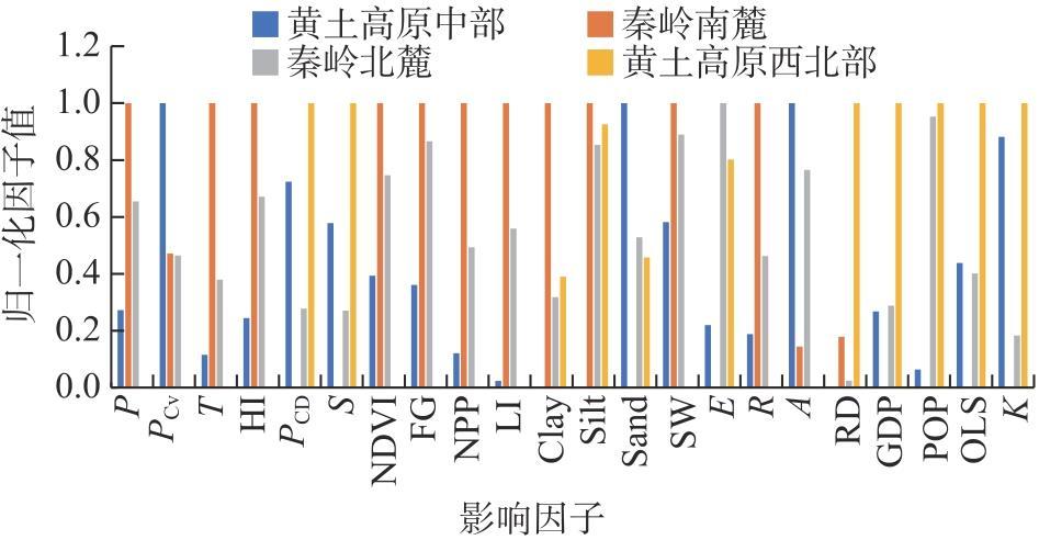
表1 生态基流控制因子体系Tab. 1 Control factors system of ecological base flow |
| 分类 | 影响因子 | 来源 |
|---|---|---|
| 气候条件 | 年降水量(P) | 由遥感数据统计 |
| 降水变异系数(PCV) | 降水量标准偏差/年降水量均值 | |
| 年平均气温(T) | 由遥感数据统计 | |
| 平均湿度指数(HI) | 降水量/潜在蒸散发 | |
| 降水集中度(PCD) | 由降水量数据计算 | |
| 地表净太阳辐射(S) | 由遥感数据统计 | |
| 植被覆盖 | 归一化植被指数(NDVI) | 由遥感数据统计 |
| 森林和草地占比(FG) | 由土地利用数据统计 | |
| 净初级生产力(NPP) | 由遥感数据统计 | |
| 叶面积指数(LI) | 由遥感数据统计 | |
| 土层结构 | 黏土比例(Clay) | 由土壤质地数据统计 |
| 粉砂土比例(Silt) | 由土壤质地数据统计 | |
| 砂土比例(Sand) | 由土壤质地数据统计 | |
| 土壤含水量(SW) | 由遥感数据统计 | |
| 地形地貌 | 集水区平均高程(E) | 由DEM计算 |
| 地表起伏度(R) | 由DEM计算 | |
| 流域形态 | 流域面积(A) | 由遥感数据统计 |
| 流域形状系数(K) | 边界长度/面积相同的圆 | |
| 河网密度(RD) | 河长/流域面积 | |
| 社会经济 | 地区生产总值(GDP) | 由遥感数据统计 |
| 人口(POP) | 由遥感数据统计 | |
| 夜间灯光(OLS) | 由遥感数据统计 |
注:DEM为数字高程模型。 |
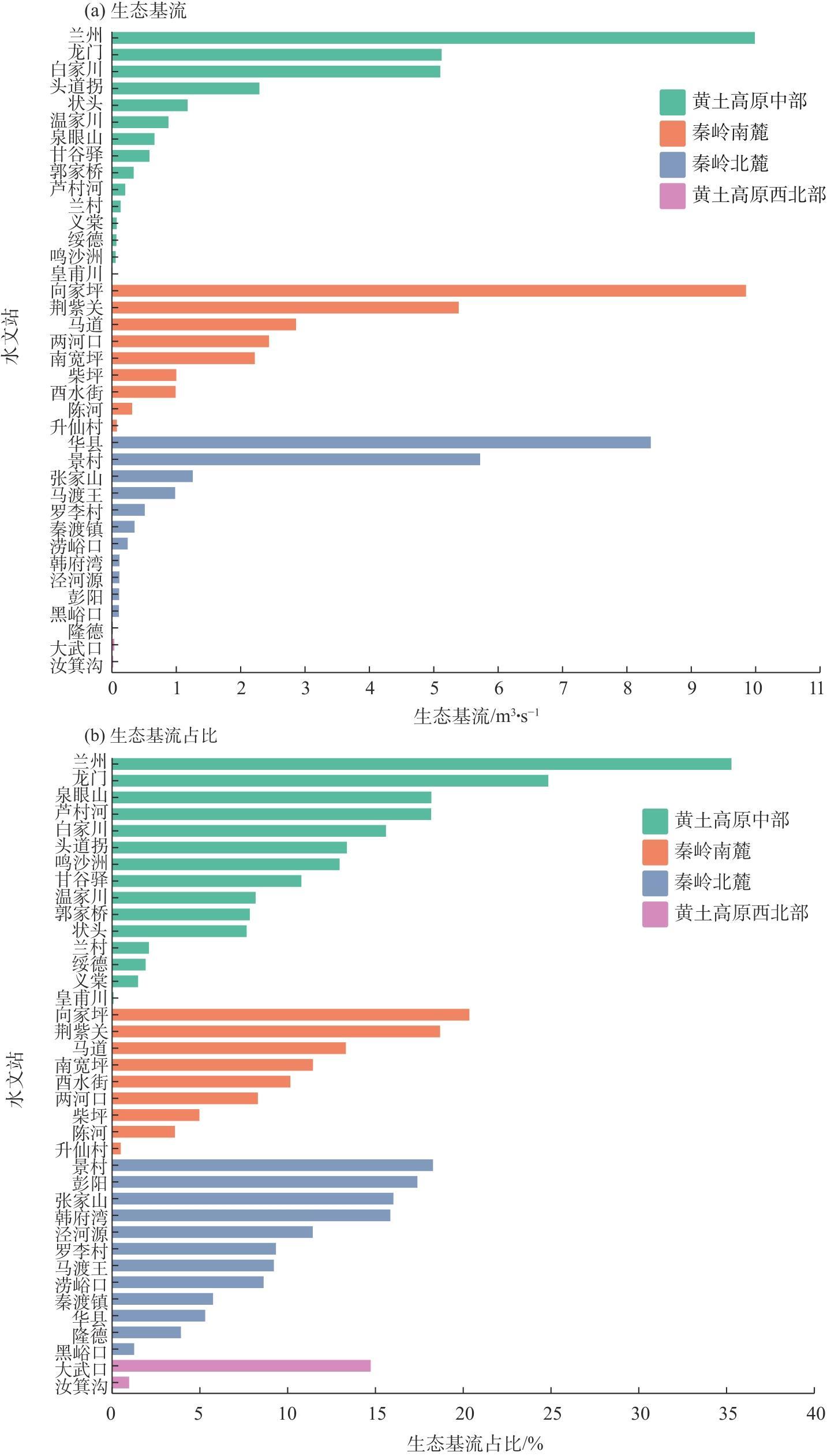
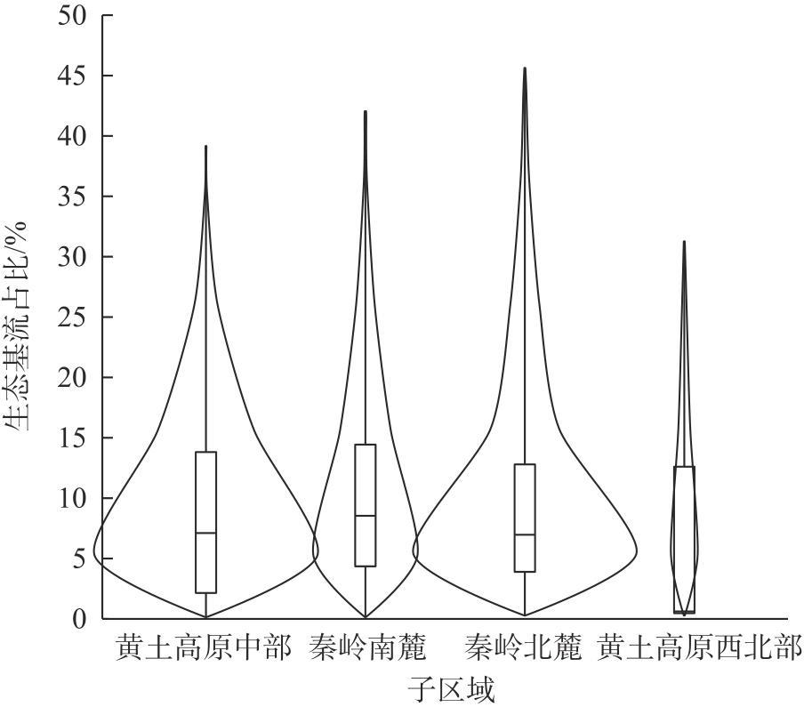
表2 子区域生态基流占比阈值Tab. 2 Sub-regional ecological base flow thresholds |
| 子区域 | 均值/% | 中值/% | 生态基流占比阈值/% |
|---|---|---|---|
| 黄土高原中部 | 8.7 | 7.1 | 7.9 |
| 秦岭南麓 | 10.5 | 8.5 | 9.5 |
| 秦岭北麓 | 7.9 | 7.0 | 7.5 |
| 黄土高原西北部 | 7.5 | 0.6 | 4.1 |
| [1] |
|
| [2] |
孙然好, 魏琳沅, 张海萍, 等. 河流生态系统健康研究现状与展望——基于文献计量研究[J]. 生态学报, 2020, 40(10): 3526-3536.
[
|
| [3] |
王中根, 赵玲玲, 陈庆伟, 等. 关于生态流量的概念解析[J]. 中国水利, 2020(15): 29-32.
[
|
| [4] |
易雨君, 张尚弘. 水生生物栖息地模拟方法及模型综述[J]. 中国科学: 技术科学, 2019, 49(4): 363-377.
[
|
| [5] |
齐丽. 太子河上游河道内适宜生态需水分析[J]. 黑龙江水利科技, 2021, 49(4): 39-41.
[
|
| [6] |
徐宗学, 武玮, 于松延. 生态基流研究: 进展与挑战[J]. 水力发电学报, 2016, 35(4): 1-11.
[
|
| [7] |
周晨晖. 生态需水理论在金塔区供水工程中的应用[J]. 黑龙江水利科技, 2024, 52(3): 111-114.
[
|
| [8] |
王一艳, 杨涛, 王伟, 等. 渭河生态基流时空分异特征及保障率分析[J]. 水资源与水工程学报, 2020, 31(3): 66-75.
[
|
| [9] |
李娟, 高建恩, 张元星, 等. 黄土高原泾河流域梯田对河道径流及生态基流影响[J]. 水土保持通报, 2015, 35(5): 106-110, 116.
[
|
| [10] |
梁鹏飞, 辛惠娟, 李宗省, 等. 祁连山黑河径流变化特征及影响因素研究[J]. 干旱区地理, 2022, 45(5): 1460-1471.
[
|
| [11] |
郑爱勤. 渭河关中段地下水对河流生态基流的保障研究[D]. 西安: 西安科技大学, 2013.
[
|
| [12] |
王慧娴, 杨蓓, 杨宁君, 等. 黄河流域旅游经济差异及关键驱动因素研究[J]. 干旱区地理, 2024, 47(3): 515-527.
[
|
| [13] |
|
| [14] |
|
| [15] |
SLT712-2021. 河湖生态环境需水计算规范[S]. 北京: 中华人民共和国水利部, 2021.
[SLT712-2021. Specification for calculation of ecological flow for rivers and lakes[S]. Beijing: The Ministry of Water Resources of the People’s Republic of China, 2021. ]
|
| [16] |
|
| [17] |
|
| [18] |
|
| [19] |
|
| [20] |
|
| [21] |
|
| [22] |
|
| [23] |
刘欢, 胡鹏, 王建华, 等. 中国河流分区分类生态基流占比阈值确定[J]. 南水北调与水利科技, 2022, 20(4): 748-756.
[
|
| [24] |
曹原, 李娅芸. 陕西省渭河控制断面生态流量目标及调度措施[J]. 地下水, 2024, 46(2): 240-242.
[
|
| [25] |
王小帆, 苗磊, 翟城武. 基于无定河生态流量保障的水资源调度研究[J]. 陕西水利, 2024(4): 32-35.
[
|
| [26] |
|
| [27] |
李婷, 吕一河, 任艳姣, 等. 黄土高原植被恢复成效及影响因素[J]. 生态学报, 2020, 40(23): 8593-8605.
[
|
| [28] |
|
| [29] |
|
| [30] |
冯憬, 卫伟, 冯青郁. 黄土丘陵区SCS-CN模型径流曲线数的计算与校正[J]. 生态学报, 2021, 41(10): 4170-4181.
[
|
| [31] |
宋林辉, 黄强, 闫迪, 等. 水力梯度对黏土渗透性影响的试验研究[J]. 岩土工程学报, 2018, 40(9): 1635-1641.
[
|
| [32] |
傅伯杰, 刘彦随, 曹智, 等. 黄土高原生态保护和高质量发展现状、问题与建议[J]. 中国科学院院刊, 2023, 38(8): 1110-1117.
[
|
| [33] |
|
| [34] |
|
/
| 〈 |
|
〉 |