
Glaciers in Saur Mountains: Current situation and evolutionary process
Received date: 2024-02-23
Revised date: 2024-05-23
Online published: 2026-03-11
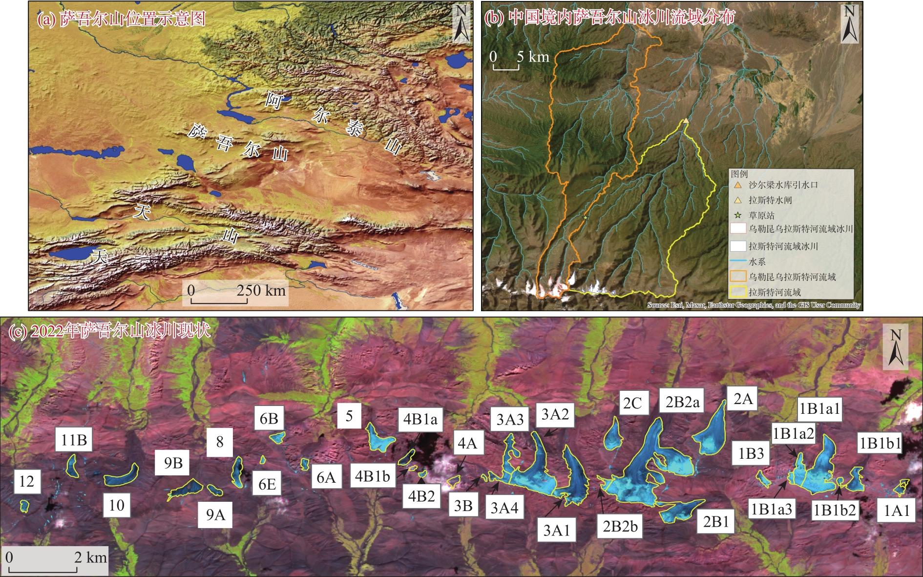
The Saur Mountains, one of the 14 mountain ranges with glaciers in western China, span across China and Kazakhstan. Although the glaciers are relatively small, scientific research is challenged by the division between two political entities. The water resources from the Saur Mountains’ glaciers are crucial for the development of Jeminay County, Xinjiang, China. This study integrates aerial topographic maps, Landsat and Sentinel satellite remote sensing images, existing glacier inventories, Google Earth high-resolution historical images, and other data. Remote sensing observations were verified on-site, and a detailed study on the current status and historical evolution of the Saur Mountains’ glaciers over the past 30 years was conducted. The results indicate that: (1) As of 2022, there are 31 glaciers in the Saur Mountains, covering a total area of 11.47 km2. The Muz Taw glacier, the largest in the range, is located in Jeminay County with an area of 2.95 km2. The remaining 90% of glaciers are each less than 1 km2, but collectively account for 54.55% of the total glacier area. The latitude height and lower altitude limit of glacier distribution in the Saur Mountains are second only to those in the Altay Mountains, making the Saur Mountains a typical high-latitude, low-altitude glacier distribution region in China. (2) Over the past 30 years, the glaciers in the Saur Mountains have experienced increased splitting, area shrinkage, and terminal retreat. The number of glaciers increased from 12 to 31, while the total glacier area decreased by 8.11 km2, a retreat rate of 41.42%. During the same period, the length of each glacier retreated by 373 m, with an average annual retreat of 11.30 m. Rising temperatures, reduced glacier albedo, and increased glacier fragmentation are the primary reasons for this retreat. (3) Compared to the other 13 mountain ranges in western China, the Saur Mountains have experienced the largest relative retreat in glacier area over the past half-century. With global warming, the glaciers in the Saur Mountains are likely to completely melt, significantly impacting the sustainable development of Jeminay County, which is already dry and water-poor. Early planning is essential to address the impending water resource crisis in Jeminay County.
Jianxin MU , Zhongqin LI , Puyu WANG , Pengbin LIANG , Yanqiang WANG , Changbin BAI , Fanglong WANG . Glaciers in Saur Mountains: Current situation and evolutionary process[J]. Arid Land Geography, 2024 , 47(8) : 1277 -1291 . DOI: 10.12118/j.issn.1000-6060.2024.112
表1 用于冰川边界解译的Landsat影像信息Tab. 1 Landsat image information for glacier boundary interpretation |
| ID | 接收日期(年-月-日) | 传感器 | 分辨率/m | 轨道号 |
|---|---|---|---|---|
| LT41440271989237XXX01 | 1989-08-25 | TM | 30 | 145/027 |
| LT51450271998245BIK00 | 1998-09-02 | TM | 30 | 145/027 |
| LT51450272006251IKR00 | 2006-09-08 | TM | 30 | 145/027 |
| LC81450272016247LGN00 | 2016-09-03 | OLI | 30 | 145/027 |
表2 用于2022年冰川边界解译的Sentinel-2影像信息Tab. 2 Sentinel-2 image information for glacier boundary interpretation in 2022 |
| ID | 接收日期(年-月-日) | 传感器 | 解译分辨率/m | 影像用途 |
|---|---|---|---|---|
| S2B_MSIL2A_20220725T051659_N0400_R062_T45TUN_20220725T080907 | 2022-07-25 | MSI | 10 | 主影像 |
| S2A_MSIL2A_20220829T051701_N0400_R062_T45TUN_20220829T095801 | 2022-08-29 | MSI | 10 | 验证补充影像 |
| S2B_MSIL2A_20220824T051649_N0400_R062_T45TUN_20220824T075837 | 2022-08-24 | MSI | 10 | 验证影像 |
| L1C_T45TUN_A027973_20220715T051825 | 2022-07-15 | MSI | 10 | 解译辅影像 |
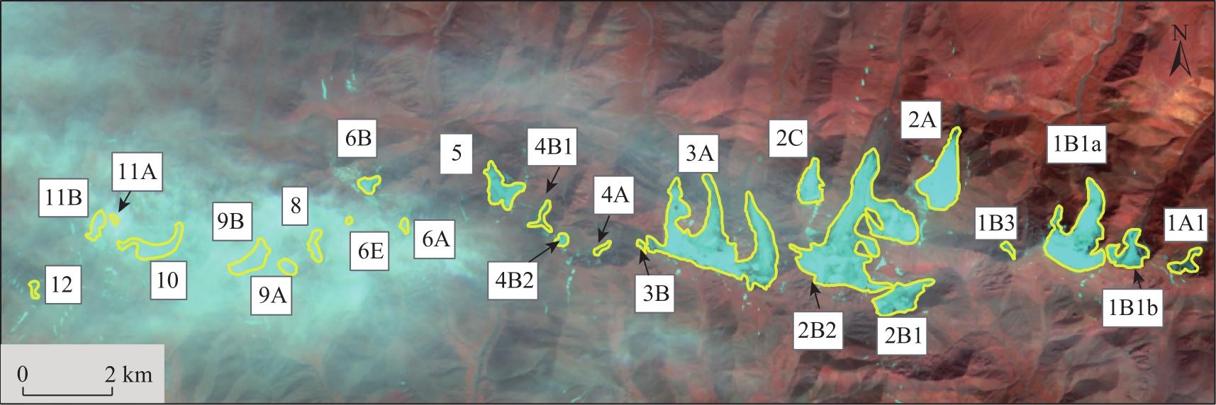
表3 2022年萨吾尔山冰川分布基本信息Tab. 3 Basic information on the distribution of glaciers in Saur Mountains in 2022 |
| 范围 | 冰川名称 | 经度/°E | 纬度/°N | 面积/km2 | 最低海拔/m | 最高海拔/m | 海拔跨度/m | 平均海拔/m | 中值海拔/m |
|---|---|---|---|---|---|---|---|---|---|
| 中国境内 | 1A1 | 85.66 | 47.06 | 0.11 | 3271 | 3647 | 376 | 3420.90 | 3425 |
| 1B1a1 | 85.63 | 47.06 | 1.09 | 3218 | 3783 | 565 | 3567.41 | 3546 | |
| 1B1a2 | 85.62 | 47.06 | 0.28 | 3248 | 3779 | 531 | 3635.20 | 3697 | |
| 1B1a3 | 85.62 | 47.06 | 0.06 | 3685 | 3766 | 81 | 3739.27 | 3745 | |
| 1B1b1 | 85.65 | 47.06 | 0.27 | 3290 | 3728 | 438 | 3487.64 | 3490 | |
| 1B1b2 | 85.64 | 47.06 | 0.04 | 3576 | 3724 | 148 | 3665.03 | 3671 | |
| 1B3 | 85.61 | 47.06 | 0.10 | 3275 | 3756 | 481 | 3516.53 | 3520 | |
| 2A | 85.59 | 47.07 | 0.92 | 3128 | 3693 | 565 | 3506.20 | 3522 | |
| 2B1 | 85.58 | 47.05 | 0.59 | 3224 | 3780 | 556 | 3497.95 | 3483 | |
| 2B2a | 85.56 | 47.06 | 2.95 | 3166 | 3827 | 661 | 3531.01 | 3544 | |
| 2B2b | 85.55 | 47.06 | 0.08 | 3568 | 3758 | 190 | 3705.46 | 3718 | |
| 2C | 85.55 | 47.07 | 0.35 | 3182 | 3700 | 518 | 3491.95 | 3494 | |
| 哈萨克斯 坦境内 | 3A1 | 85.54 | 47.06 | 0.98 | 3174 | 3712 | 538 | 3418.67 | 3418 |
| 3A2 | 85.52 | 47.06 | 1.20 | 3051 | 3714 | 663 | 3506.64 | 3529 | |
| 3A3 | 85.51 | 47.06 | 0.32 | 3210 | 3646 | 436 | 3515.26 | 3557 | |
| 3A4 | 85.51 | 47.06 | 0.16 | 3421 | 3693 | 272 | 3613.99 | 3638 | |
| 3B | 85.50 | 47.06 | 0.01 | 3426 | 3616 | 190 | 3521.53 | 3512 | |
| 4A | 85.49 | 47.06 | 0.08 | 3178 | 3447 | 269 | 3271.90 | 3266 | |
| 4B1a | 85.47 | 47.06 | 0.11 | 3275 | 3459 | 184 | 3364.50 | 3367 | |
| 4B1b | 85.47 | 47.06 | 0.03 | 3536 | 3639 | 103 | 3591.43 | 3594 | |
| 4B2 | 85.48 | 47.06 | 0.04 | 3518 | 3657 | 139 | 3602.27 | 3610 | |
| 5 | 85.46 | 47.07 | 0.36 | 3206 | 3722 | 516 | 3568.88 | 3632 | |
| 6A | 85.43 | 47.06 | 0.07 | 3251 | 3592 | 341 | 3399.24 | 3390 | |
| 6B | 85.42 | 47.07 | 0.11 | 3347 | 3691 | 344 | 3562.03 | 3587 | |
| 6E | 85.42 | 47.06 | 0.02 | 3464 | 3590 | 126 | 3544.19 | 3556 | |
| 8 | 85.41 | 47.06 | 0.22 | 3252 | 3634 | 382 | 3449.19 | 3440 | |
| 9A | 85.40 | 47.05 | 0.09 | 3273 | 3434 | 161 | 3349.45 | 3352 | |
| 9B | 85.39 | 47.05 | 0.30 | 3211 | 3454 | 243 | 3290.22 | 3287 | |
| 10 | 85.36 | 47.06 | 0.34 | 3163 | 3423 | 260 | 3289.50 | 3295 | |
| 11B | 85.34 | 47.06 | 0.16 | 3329 | 3590 | 261 | 3494.12 | 3518 | |
| 12 | 85.32 | 47.05 | 0.03 | 3228 | 3431 | 203 | 3316.89 | 3310 |
表4 萨吾尔山冰川条数演变Tab. 4 Evolution of glacier number in Saur Mountains |
| 年份 | 冰川数量/条 | 冰川数量/条 | |
|---|---|---|---|
| 中国境内 | 哈萨克斯坦境内 | ||
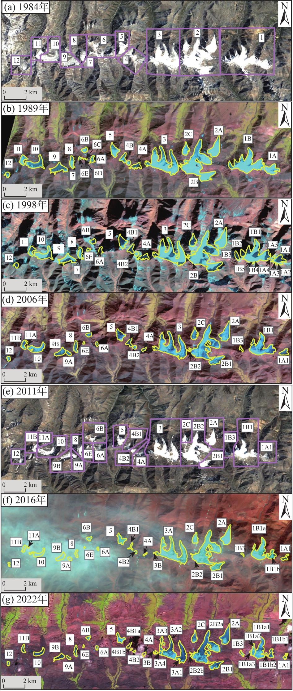
| 1984 | 12 | 2 | 10 |
| 1989 | 20 | 5 | 15 |
| 1998 | 27 | 13 | 14 |
| 2006 | 22 | 7 | 15 |
| 2016 | 24 | 8 | 16 |
| 2022 | 31 | 12 | 19 |
表5 萨吾尔山冰川面积变化Tab. 5 Changes of glacier area in Saur Mountains |
| 年份 | 冰川面积/km2 | 冰川面积/km2 | |
|---|---|---|---|
| 中国境内 | 哈萨克斯坦境内 | ||
| 1989 | 19.58 | 10.35 | 9.23 |
| 1998 | 16.779 | 8.955 | 7.824 |
| 2006 | 14.59 | 8.13 | 6.46 |
| 2016 | 12.89 | 7.22 | 5.67 |
| 2022 | 11.47 | 6.84 | 4.63 |
表6 萨吾尔山冰川长度变化Tab. 6 Changes of glacier length in Saur Mountains |
| 年份 | 冰川长度/km | 冰川长度/km | |
|---|---|---|---|
| 中国境内 | 哈萨克斯坦境内 | ||
| 1989 | 25.24 | 10.54 | 14.70 |
| 1998 | 23.14 | 9.86 | 13.28 |
| 2006 | 20.93 | 9.55 | 11.38 |
| 2016 | 19.31 | 8.87 | 10.44 |
| 2022 | 17.78 | 8.26 | 9.52 |
表7 1989—2022年萨吾尔山冰川面积及长度分布Tab. 7 Distribution of glacier area and length in Saur Mountains from 1989 to 2022 |
| 范围 | 冰川编号 | 1989年 | 1998年 | 2006年 | 2016年 | 2022年 | ||||||||||||||
|---|---|---|---|---|---|---|---|---|---|---|---|---|---|---|---|---|---|---|---|---|
| 面积/km2 | 长度/km | 面积/km2 | 长度/km | 面积/km2 | 长度/km | 面积/km2 | 长度/km | 面积/km2 | 长度/km | |||||||||||
| 国内 | 1 | 1A | 1A1 | 0.90 | 1.18 | 0.34 | 0.90 | 0.32 | 0.85 | 0.19 | 0.78 | 0.11 | 0.56 | |||||||
| 1A2 | 0.01 | 0.06 | ||||||||||||||||||
| 1A3 | 0.01 | 0.08 | ||||||||||||||||||
| 1A4 | 0.02 | 0.26 | ||||||||||||||||||
| 1A5 | 0.01 | 0.13 | ||||||||||||||||||
| 1B | 1B1 | 1B1a | 1B1a1 | 3.18 | 2.39 | 2.54 | 2.23 | 2.23 | 2.15 | 1.55 | 1.90 | 1.09 | 1.70 | |||||||
| 1B1a2 | 0.28 | 0.80 | ||||||||||||||||||
| 1B1a3 | 0.06 | 0.30 | ||||||||||||||||||
| 1B1b | 1B1b1 | 0.46 | 0.98 | 0.27 | 0.80 | |||||||||||||||
| 1B1b2 | 0.04 | 0.26 | ||||||||||||||||||
| 1B2 | 0.05 | 0.57 | ||||||||||||||||||
| 1B3 | 0.13 | 0.79 | 0.12 | 0.60 | 0.05 | 0.43 | 0.10 | 0.51 | ||||||||||||
| 1B4 | 0.002 | 0.05 | ||||||||||||||||||
| 1B5 | 0.003 | 0.07 | ||||||||||||||||||
| 2 | 2A | 1.12 | 2.09 | 1.09 | 2.07 | 1.05 | 2.04 | 0.88 | 1.77 | 0.92 | 1.80 | |||||||||
| 2B | 2B1 | 4.65 | 3.62 | 4.30 | 3.43 | 0.67 | 1.60 | 0.59 | 1.38 | 0.59 | 1.40 | |||||||||
| 2B2 | 2B2a | 3.34 | 3.32 | 3.13 | 3.20 | 2.95 | 3.10 | |||||||||||||
| 2B2b | 0.08 | 0.45 | ||||||||||||||||||
| 2C | 0.50 | 1.26 | 0.45 | 1.23 | 0.40 | 1.22 | 0.37 | 1.22 | 0.35 | 1.10 | ||||||||||
| 国外 | 3 | 3A | 3A1 | 3.72 | 2.62 | 3.42 | 2.58 | 3.14 | 2.39 | 3.08 | 2.32 | 0.98 | 1.95 | |||||||
| 3A2 | 1.20 | 2.10 | ||||||||||||||||||
| 3A3 | 0.32 | 1.30 | ||||||||||||||||||
| 3A4 | 0.16 | 0.70 | ||||||||||||||||||
| 3B | 0.03 | 0.28 | 0.01 | 0.20 | ||||||||||||||||
| 4 | 4A | 0.54 | 0.88 | 0.38 | 0.87 | 0.11 | 0.55 | 0.04 | 0.41 | 0.08 | 0.50 | |||||||||
| 4B | 4B1 | 4B1a | 0.54 | 1.01 | 0.31 | 0.92 | 0.30 | 0.85 | 0.1 | 0.69 | 0.11 | 0.67 | ||||||||
| 4B1b | 0.03 | 0.26 | ||||||||||||||||||
| 4B2 | 0.12 | 0.43 | 0.09 | 0.34 | 0.08 | 0.29 | 0.04 | 0.27 | ||||||||||||
| 5 | 0.68 | 1.44 | 0.59 | 1.35 | 0.53 | 1.18 | 0.43 | 1.17 | 0.36 | 1.01 | ||||||||||
| 6 | 6A | 0.26 | 0.98 | 0.18 | 0.71 | 0.05 | 0.34 | 0.05 | 0.33 | 0.07 | 0.38 | |||||||||
| 6B | 0.23 | 0.72 | 0.20 | 0.70 | 0.16 | 0.53 | 0.14 | 0.47 | 0.11 | 0.44 | ||||||||||
| 6C | 0.03 | 0.16 | ||||||||||||||||||
| 6D | 0.03 | 0.27 | ||||||||||||||||||
| 6E | 0.08 | 0.42 | 0.04 | 0.27 | 0.03 | 0.14 | 0.02 | 0.12 | 0.02 | 0.12 | ||||||||||
| 7 | 0.01 | 0.11 | 0.004 | 0.06 | ||||||||||||||||
| 8 | 0.38 | 1.23 | 0.33 | 1.16 | 0.29 | 1.09 | 0.25 | 1.05 | 0.22 | 1.02 | ||||||||||
| 9 | 9A | 0.91 | 1.38 | 0.75 | 1.29 | 0.14 | 0.63 | 0.14 | 0.62 | 0.09 | 0.50 | |||||||||
| 9B | 0.44 | 1.22 | 0.44 | 1.20 | 0.30 | 0.98 | ||||||||||||||
| 10 | 1.14 | 1.72 | 0.95 | 1.71 | 0.73 | 1.58 | 0.54 | 1.51 | 0.34 | 1.20 | ||||||||||
| 11 | 11A | 0.46 | 1.11 | 0.38 | 1.08 | 0.04 | 0.42 | 0.04 | 0.39 | |||||||||||
| 11B | 0.27 | 0.94 | 0.25 | 0.85 | 0.16 | 0.80 | ||||||||||||||
| 12 | 0.22 | 0.65 | 0.17 | 0.58 | 0.14 | 0.57 | 0.04 | 0.32 | 0.03 | 0.30 | ||||||||||
表8 中国西部14座山系冰川变化比较Tab. 8 Comparison of glacier changes in 14 mountains in western China |
| 山脉 | 年份 | 面积变化/km2 | 年平均面积变化/km2∙a-1 | 面积变化率/% | 年平均面积变化率/%∙a-1 | 资料来源 |
|---|---|---|---|---|---|---|
| 阿尔泰山 | 1960—2009 | -104.61 | -2.13 | -36.91 | -0.75 | 姚晓军等[29] |
| 萨吾尔山 | 1959—2006 | -7.75 | -0.16 | -48.80 | -1.04 | 本研究 |
| 天山 | 1959—2009 | -1619.82 | -32.40 | -18.41 | -0.37 | 邢武成等[30] |
| 喀喇昆仑山 | 1978—2015 | -237.55 | -6.42 | -7.77 | -0.21 | 许艾文[31] |
| 帕米尔高原 | 1963—2009 | -248.70 | -5.41 | -10.80 | -0.24 | Zhang等[32] |
| 昆仑山 | 1970—2010 | -95.06 | -2.38 | -13.60 | -0.34 | Bao等[33] |
| 阿尔金山 | 1973—2015 | -58.78 | -1.40 | -16.80 | -0.40 | 胡凡盛等[34] |
| 祁连山 | 1956—2010 | -420.81 | -7.79 | -20.88 | -0.39 | Sun等[35] |
| 唐古拉山 | 1969—2015 | -524.80 | -11.41 | -24.00 | -0.52 | Duan等[36] |
| 羌塘高原 | 1970—2000 | - 90.12 | -3.00 | -4.35 | -0.15 | 王利平等[37] |
| 冈底斯山 | 1970—2016 | -854.05 | -18.57 | -39.53 | -0.86 | Liu等[38] |
| 喜马拉雅山 | 1990—2015 | -2553.10 | -102.12 | -10.99 | -0.44 | 冀琴等[39] |
| 念青唐古拉山 | 1980—2016 | -1000.61 | -27.79 | -10.80 | -0.30 | 邸宝刚[40] |
| 横断山 | 1973—2013 | -278.57 | -7.53 | -41.81 | -1.13 | 李霞[41] |
| [1] |
IPCC. Climate change 2021:The physical science basis. Contribution of working group I to the sixth assessment report of the intergovernmental panel on climate change[M]. Cambridge: Cambridge University Press, 2021.
|
| [2] |
|
| [3] |
牟建新, 李忠勤, 张慧, 等. 全球冰川面积现状及近期变化——基于2017年发布的Randolph冰川编目[J]. 冰川冻土, 2018, 40(2): 238-248.
[
|
| [4] |
马丽娟, 效存德, 康世昌. 全球主要山地气候变化特征和异同——IPCC AR6 WGI报告和SROCC综合解读[J]. 气候变化研究进展, 2022, 18(5): 605-621.
[
|
| [5] |
|
| [6] |
刘时银, 姚晓军, 郭万钦, 等. 基于第二次冰川编目的中国冰川现状[J]. 地理学报, 2015, 70(1): 3-16.
[
|
| [7] |
王宁练, 姚檀栋, 徐柏青, 等. 全球变暖背景下青藏高原及周边地区冰川变化的时空格局与趋势及影响[J]. 中国科学院院刊, 2019, 34(11): 1220-1232.
[
|
| [8] |
王宗太. 中国各山脉的冰川最新统计及其分布特征[J]. 干旱区地理, 1988, 11(3): 8-14.
[
|
| [9] |
|
| [10] |
怀保娟, 李忠勤, 王飞腾, 等. 1959—2013年中国境内萨吾尔山冰川变化特征[J]. 冰川冻土, 2015, 37(5): 1141-1149.
[
|
| [11] |
|
| [12] |
王炎强, 赵军, 李忠勤, 等. 1977—2017年萨吾尔山冰川变化及其对气候变化的响应[J]. 自然资源学报, 2019, 34(4): 802-814.
[
|
| [13] |
尹立东. 萨吾尔山地植被概况[J]. 植物生态学与地植物学学报, 1986, 10(4): 316-322.
[
|
| [14] |
|
| [15] |
|
| [16] |
|
| [17] |
|
| [18] |
张慧, 李忠勤, 牟建新, 等. 近50年新疆天山奎屯河流域冰川变化及其对水资源的影响[J]. 地理科学, 2017, 37(11): 1771-1777.
[
|
| [19] |
姚晓军, 刘时银, 朱钰, 等. 基于GIS的冰川中流线自动提取方法设计与实现[J]. 冰川冻土, 2015, 37(6): 1563-1570.
[
|
| [20] |
中国气象局国家气候中心. 中国气候变化蓝皮书(2023)[M]. 北京: 科学出版社, 2023.
[National Climate Centre of China Meteorological Administration. Blue book on climate change in China (2023)[M]. Beijing: Science Press, 2023.]
|
| [21] |
李忠勤. 山地冰川物质平衡和动力过程模拟[M]. 北京: 科学出版社, 2019.
[
|
| [22] |
|
| [23] |
|
| [24] |
|
| [25] |
毛瑞娟, 蒋熹, 郭忠明, 等. 基于TM/ETM+影像反演祁连山七一冰川反照率精度比较研究[J]. 冰川冻土, 2013, 35(2): 301-309.
[
|
| [26] |
|
| [27] |
|
| [28] |
刘时银, 张勇, 刘巧, 等. 气候变化影响与风险: 气候变化对冰川影响与风险研究[M]. 北京: 科学出版社, 2017.
[
|
| [29] |
姚晓军, 刘时银, 郭万钦, 等. 近50 a来中国阿尔泰山冰川变化——基于中国第二次冰川编目成果[J]. 自然资源学报, 2012, 27(10): 1734-1745.
[
|
| [30] |
邢武成, 李忠勤, 张慧, 等. 1959年来中国天山冰川资源时空变化[J]. 地理学报, 2017, 72(9): 1594-1605.
[
|
| [31] |
许艾文. 近40年中国喀喇昆仑山冰川变化的遥感监测[D]. 兰州: 兰州大学, 2017.
[
|
| [32] |
|
| [33] |
|
| [34] |
胡凡盛, 杨太保, 冀琴, 等. 近40 a阿尔金山冰川与气候变化关系研究[J]. 干旱区地理, 2017, 40(3): 581-588.
[
|
| [35] |
|
| [36] |
|
| [37] |
王利平, 谢自楚, 刘时银, 等. 1970—2000年羌塘高原冰川变化及其预测研究[J]. 冰川冻土, 2011, 33(5): 979-990.
[
|
| [38] |
|
| [39] |
冀琴, 刘睿, 杨太保. 1990—2015年喜马拉雅山冰川变化的遥感监测[J]. 地理研究, 2020, 39(10): 2403-2414.
[
|
| [40] |
邸宝刚. 念青唐古拉山脉36年来冰川变化及其对气候变化的响应[D]. 北京: 中国地质大学(北京), 2019.
[
|
| [41] |
李霞. 近40年横断山冰川变化的遥感监测研究[D]. 兰州: 兰州大学, 2015.
[
|
/
| 〈 |
|
〉 |