
Development and utilization potential of surface water resources of the counties on the northern slope of Kunlun Mountains from the perspective of supply and demand balance
Received date: 2024-02-26
Revised date: 2024-04-03
Online published: 2026-03-11
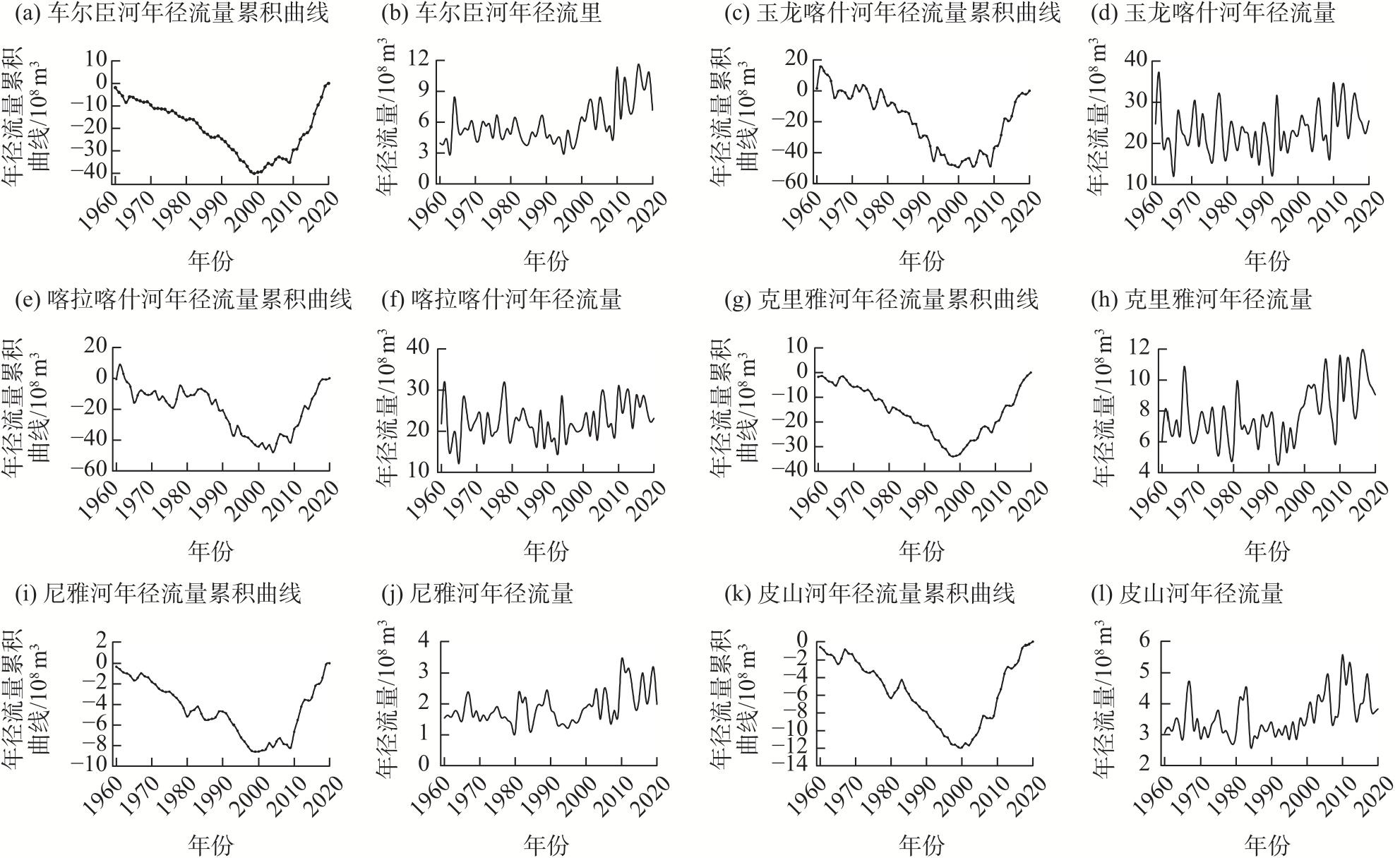
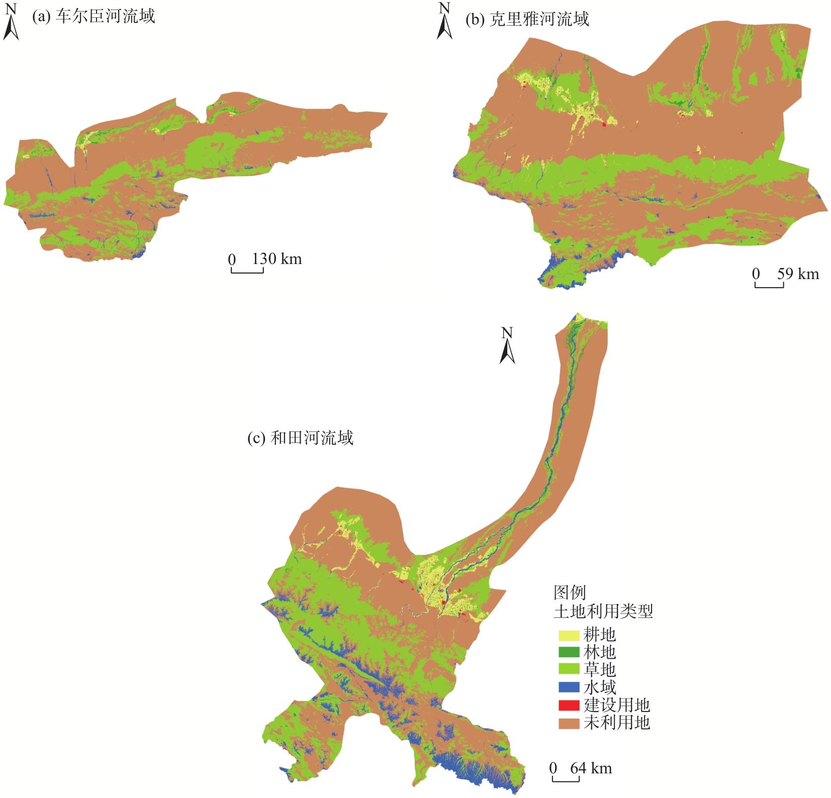
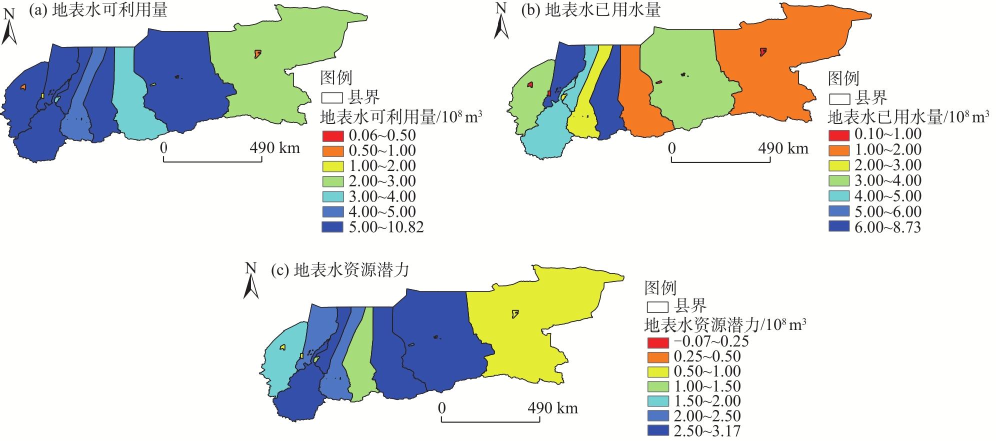
Quantitative analysis of the water resources potential is helpful for determining the amount of regional water resources. This in turn is significant for guiding scientific planning and sustainable utilization of regional water resources in the future. In this study, we initially discussed the surface water resources potential of the county units on the northern slope of the Kunlun Mountains by balancing water supply and demand. The analysis considered surface runoff, ecological water demand, and the amount of available surface water to determine the necessity of protecting water resources in this region. The results showed that: (1) The runoff of rivers on the northern slope of the Kunlun Mountains showed a significant increase after 2000, with the average annual runoff increasing by 23.36% from 2001 to 2010 and 42.89% from 2011 to 2020 compared with that before 2000, among which the Qarqan River showed the largest increase and the Hotan River showed the smallest increase. (2) The ecological base flows for the Qarqan River Basin, Keriya River Basin, and Hotan River Basin were 4.67×10⁸ m3, 5.38×10⁸ m3, and 20.26×10⁸ m3, respectively, and the ecological water demands of natural vegetation were 4.34×10⁸ m3, 4.00×10⁸ m3, and 2.62×10⁸ m3, respectively. (3) The current surface water consumption of each county unit on the northern slope of the Kunlun Mountains ranged from 0.1×10⁸ to 8.73×10⁸ m3, and the potential of surface water resources ranged from −0.07×10⁸ to 3.17×10⁸ m3; additionally, the spatial difference was significant. The surface water resource potential was greater than 2.00×10⁸ m3 in Moyu County, Tiemenguan City 38th Regiment, Qira County, Qiemo County, Hotan County, Minfeng County, and Lop County. The current surface water resources storage capacity of the region is insufficient, and the use of water resources is relatively low. Despite the significant surface water potential of this region, it is difficult to use this water due to regional characteristics; consequently, in the future, the county units on the northern slope of the Kunlun Mountains need to formulate and revise a more appropriate surface water resources usage plan and strengthen the construction of basic surface water conservancy projects to enhance the efficiency of surface water resources allocation and utilization, thus ensuring water resources support for facilitating the region’s development.
Honghua ZHOU , Yuhai YANG , Chenggang ZHU , Gonghuan FANG . Development and utilization potential of surface water resources of the counties on the northern slope of Kunlun Mountains from the perspective of supply and demand balance[J]. Arid Land Geography, 2024 , 47(7) : 1106 -1115 . DOI: 10.12118/j.issn.1000-6060.2024.093
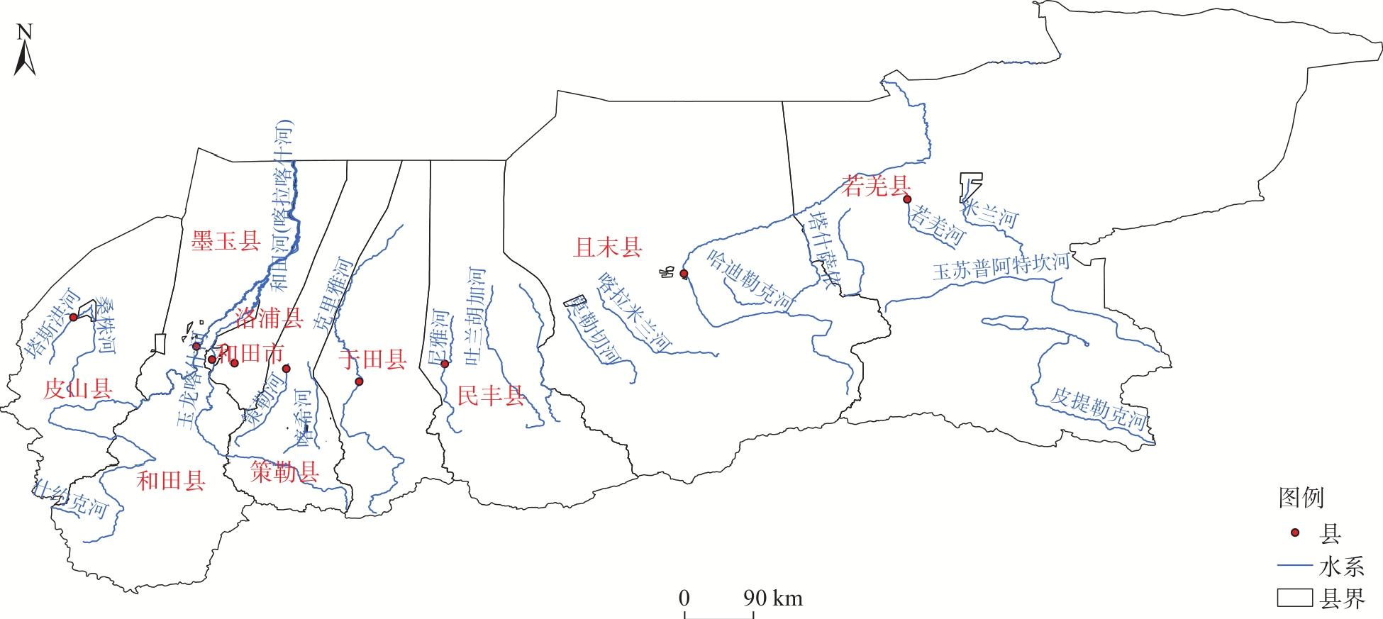
表1 各流域河流行政区归属和2011—2020年的年均径流量Tab. 1 Administrative affiliation of rivers in each basin and their average annual runoff from 2011 to 2020 |
| 流域 | 河流 | 径流量/108 m3 | 行政区 |
|---|---|---|---|
| 车尔臣河流域 | 车尔臣河、江尕萨依河、安迪尔河、塔什萨依河 | 12.60 | 且末县、37团 |
| 莫勒切河、喀拉米兰河 | 5.55 | 38团 | |
| 若羌河、瓦石峡河、塔什萨依河 | 3.66 | 若羌县 | |
| 米兰河 | 1.63 | 36团 | |
| 合计 | 23.44 | ||
| 和田河流域 | 喀拉喀什河 | 25.68 | 和田县(喀河灌区)、墨玉县、224团、47团 |
| 玉龙喀什河 | 26.88 | 和田县(玉河灌区)、和田市、洛浦县 | |
| 皮山河、苏勒阿孜河、桑株河、波斯干河、杜瓦河 | 8.58 | 皮山县、皮山农场 | |
| 合计 | 61.14 | ||
| 克里雅河流域 | 策勒河、恰哈河、乌鲁克萨依河、努尔河、萨尔龙河、萨依巴格河、阿克萨音河、卡尔苏河、布藏河 | 7.90 | 策勒县、一牧场 |
| 克里雅河、吐米亚河、皮什盖河、阿羌河、苏克塔克牙河 | 11.78 | 于田县、225团 | |
| 尼雅河、安迪尔河、牙通古孜河、叶亦克河、其其汗河 | 7.19 | 民丰县 | |
| 合计 | 26.87 | ||
| 总计 | 111.45 |
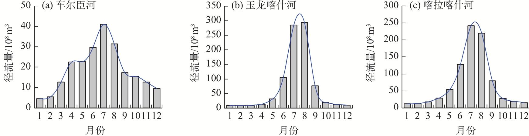
图3 2011—2020年昆仑山北坡主要河流的径流量年内分布Fig. 3 Annual distributions of main stream flows on the northern slope of the Kunlun Mountains from 2011 to 2020 |
表2 县域单元内各河流的生态基流和河岸植被生态需水量Tab. 2 Ecological baseflow and riparian vegetation ecological water demand for each stream in the counties |
| 流域 | 行政区 | 河流生态基流/108 m3 | 天然植被生态需水/108 m3 | 合计/108 m3 |
|---|---|---|---|---|
| 车尔臣河流域 | 若羌县 | 0.73 | 0.53 | 1.26 |
| 36团 | 0.33 | 0.31 | 0.64 | |
| 38团 | 1.11 | 1.48 | 2.59 | |
| 且末县、37团 | 2.50 | 2.02 | 4.52 | |
| 合计 | 4.67 | 4.34 | 9.01 | |
| 克里雅河流域 | 民丰县 | 1.44 | 1.79 | 3.23 |
| 于田县、225团 | 2.36 | 0.85 | 3.21 | |
| 策勒县、一牧场 | 1.58 | 1.36 | 2.94 | |
| 合计 | 5.38 | 4.00 | 9.38 | |
| 和田河流域 | 洛浦县、和田市、和田县 | 13.27(含塔河输送水量) | 1.48 | 14.75 |
| 和田县、墨玉县、47团、224团 | 5.27(含塔河输送水量) | 0.81 | 6.08 | |
| 皮山县、皮山农场 | 1.72 | 0.33 | 2.05 | |
| 合计 | 20.26 | 2.62 | 22.88 | |
| 总计 | 30.31 | 10.96 | 41.27 | |
| [1] |
|
| [2] |
李丽, 刘诗奇, 王平, 等. 基于负载指数的中蒙俄经济走廊水资源开发潜力评价[J]. 干旱区研究, 2021, 38(4): 910-918.
[
|
| [3] |
王旋旋, 陈亚宁, 李稚, 等. 基于模糊综合评价模型的中亚水资源开发潜力评估[J]. 干旱区地理, 2020, 43(1): 127-134.
[
|
| [4] |
陈亚宁, 李稚, 方功焕, 等. 气候变化对中亚天山山区水资源影响研究[J]. 地理学报, 2017, 72(1): 18-26.
[
|
| [5] |
张凯, 韩永翔, 张勃, 等. 黑河中游水资源开发利用的阶段潜力研究[J]. 地理科学, 2006, 26(2): 179-185.
[
|
| [6] |
|
| [7] |
郭巧玲, 杨琳洁, 李恩宽. 额济纳绿洲植被生态需水量空间分布[J]. 干旱区资源与环境, 2013, 27(8): 103-107.
[
|
| [8] |
|
| [9] |
崔彩霞, 魏荣庆, 李杨. 塔里木河上游地区积雪长期变化趋势及其对径流量的影响[J]. 干旱区地理, 2005, 28(5): 569-573.
[
|
| [10] |
|
| [11] |
|
| [12] |
陈亚宁, 李稚, 范玉婷, 等. 西北干旱区气候变化对水文水资源影响研究进展[J]. 地理学报, 2014, 69(9): 1-10.
[
|
| [13] |
|
| [14] |
|
| [15] |
黄星, 陈伏龙, 赵琪, 等. 新疆和田河径流丰枯评价及组合分析[J]. 干旱区研究, 2021, 38(6): 1570-1578.
[
|
/
| 〈 |
|
〉 |