
Remote sensing extraction of jujube planting area in Xinjiang based on RF classification optimization and SNIC clustering
Received date: 2023-07-23
Revised date: 2023-10-07
Online published: 2026-03-11
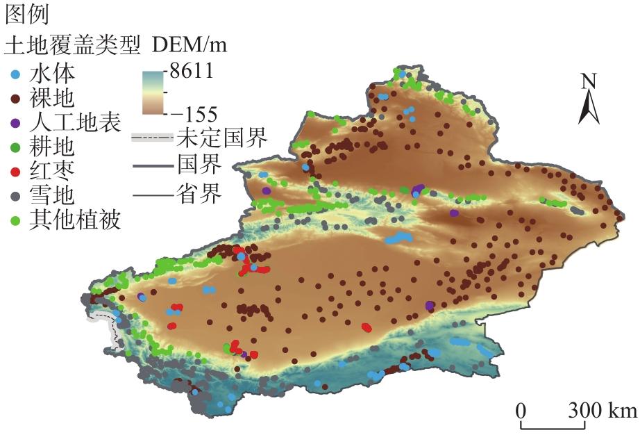
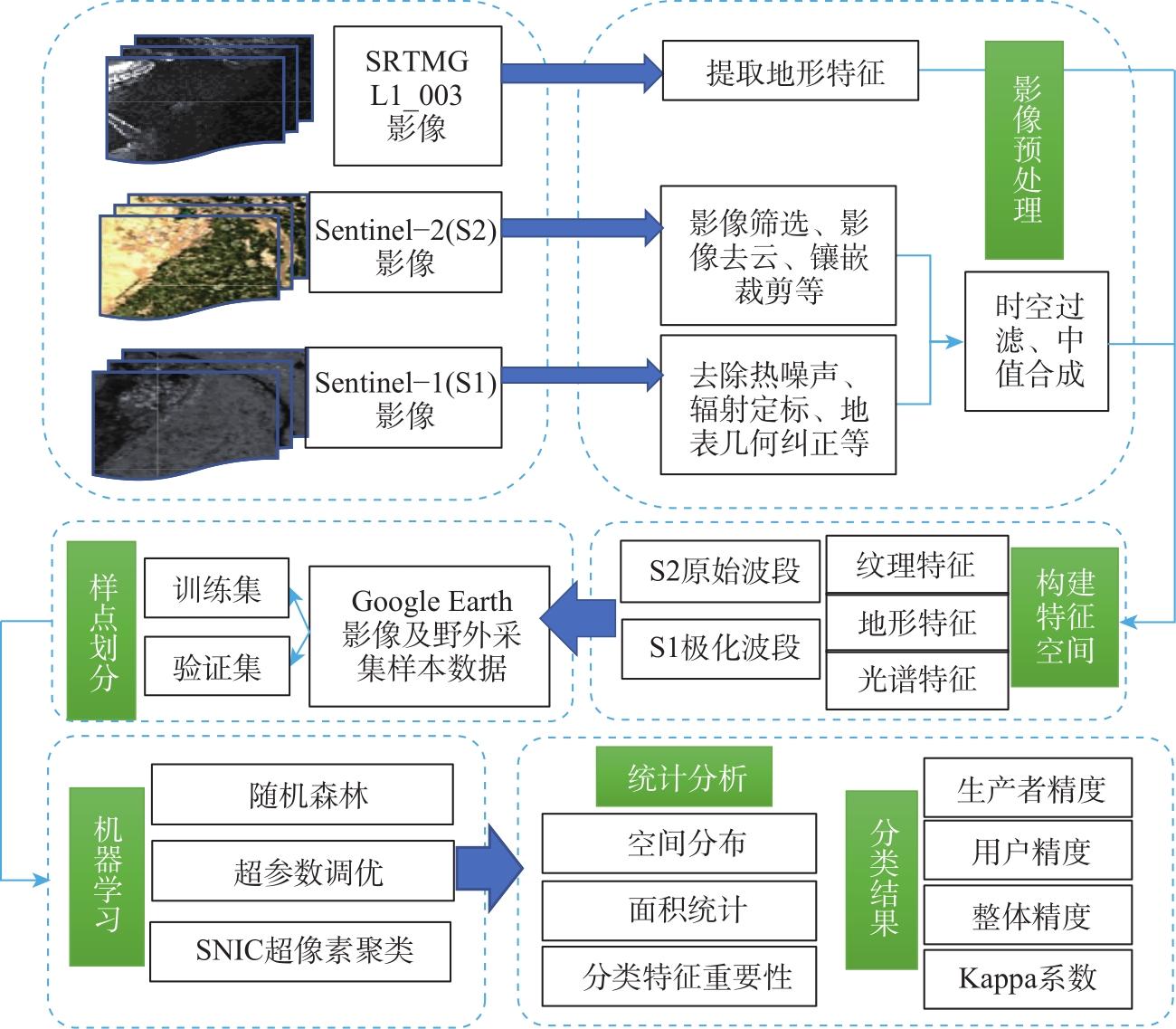
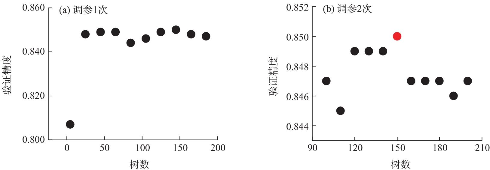
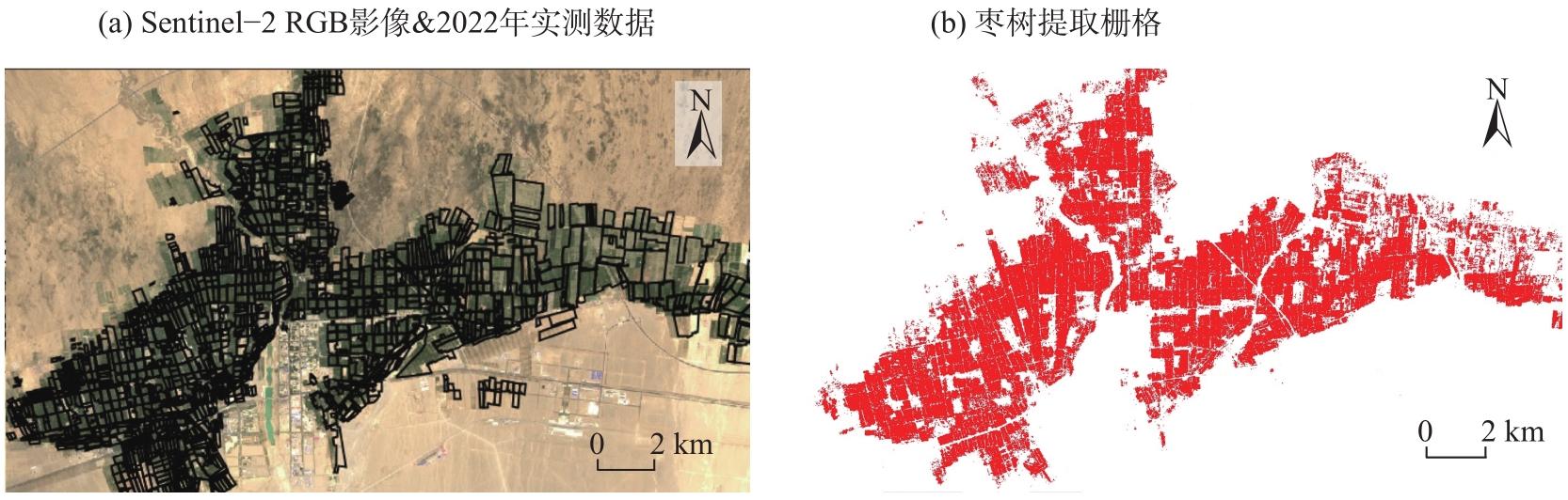
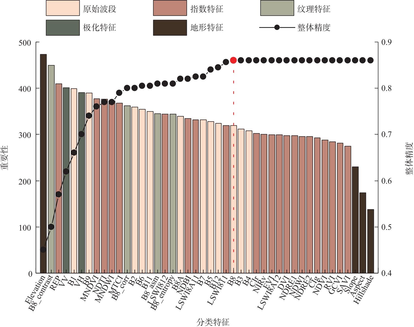
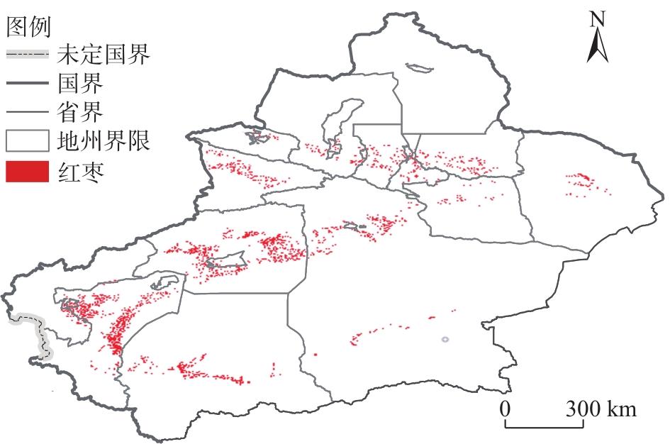
This study aims to efficiently extract the distribution information and planting area of jujube crops in Xinjiang, China, providing essential data support for predicting yield and price, consolidating poverty alleviation achievements, and aiding rural revitalization. Utilizing the Google Earth Engine cloud platform, this research accesses Sentinel-1 radar images, Sentinel-2 optical images, and SRTM terrain data covering Xinjiang. From these data, 44 features including spectral, textural, and terrain attributes are extracted, followed by a feature selection process. The optimized random forest classifier, after hyperparameter tuning, produces a spatial distribution map of Xinjiang’s jujube planting areas with a 10 m resolution for the year 2021. Superpixel clustering method further processes the major jujube planting areas to determine the exact planting extents. The findings are as follows: (1) Employing a simple non-iterative clustering algorithm for classification and post-processing, the identified jujube cultivated area in Xinjiang spans 4253 km², predominantly located in the southern regions of Aksu, Kashgar, Hotan Prefectures, and Bayingolin Mongol Autonomous Prefecture, as well as Turpan and Hami Cities in the east. (2) The accuracy of feature extraction is significantly enhanced through hyperparameter optimization of the random forest classifier, yielding an average overall classification accuracy of 0.86, a Kappa coefficient of 0.82, a producer accuracy for jujube extraction of 0.87, and a user accuracy of 0.80, as assessed via the confusion matrix. (3) Features from the Sentinel-1 polarization band are crucial for jujube information extraction, supplemented effectively by spectral and textural features. Leveraging multisource remote sensing data, this method facilitates rapid acquisition of distribution and area data for jujube planting in Xinjiang, markedly benefiting agricultural modernization, resource conservation, and regional economic development.
Guobing ZHAO , Jianghua ZHENG , Lei WANG , Jian GAO , Lei LUO , TUERXUN Nigela , Wanqiang HAN , Jingyun GUAN . Remote sensing extraction of jujube planting area in Xinjiang based on RF classification optimization and SNIC clustering[J]. Arid Land Geography, 2024 , 47(6) : 1004 -1014 . DOI: 10.12118/j.issn.1000-6060.2023.382
表1 影像数据Tab. 1 Image data |
| 影像数据集 | 选取数据 | 预处理 | 目的 |
|---|---|---|---|
| Sentinel-1(S1) | 选取干涉模式为IW,极化方式为VV+VH,时间为 2021-06-01至2021-08-01,共108景 | 标定轨道参数、边界噪音去除、去除热噪声、辐射定标、地形校正等,最终得到数据产品的空间分辨率为10 m | 选用后向散射系数VV和VH作为独立波段参与特征构建 |
| Sentinel-2(S2) | 选取Level-2A产品数据,时间为 2021-06-01至2021-08-01,共2018景 | 辐射定标、几何校正、大气校正等,空间分辨率为10 m;其中QA60波段用来去云 | 提取原始12个波段并计算22个指数特征,基于Sentinel-2的B8近红外波段生成4种主要的纹理特征 |
| SRTMGL1_003 | 空间分辨率为30 m | 使用resample函数进行重采样,并用reproject函数将分辨率调整至10 m | 计算4种常用的地形特征 |
表2 样本数据Tab. 2 Sample data |
| 地类代码 | 地类名称 | 样本数量/个 |
|---|---|---|
| 0 | 水体 | 180 |
| 1 | 裸地 | 456 |
| 2 | 人工地表 | 308 |
| 3 | 耕地 | 1356 |
| 4 | 红枣 | 1363 |
| 5 | 雪地 | 300 |
| 6 | 其他植被 | 1330 |
| 总计 | 5293 |
表3 参与分类的特征Tab. 3 Features involved in classification |
| 简称 | 分类特征 | 简称 | 分类特征 |
|---|---|---|---|
| B1 | 气溶胶 | LSWI812 | 地表水分指数B8&B12 |
| B2 | 蓝 | MNDWI | 改进的归一化水指数 |
| B3 | 绿 | EVI | 增强植被指数 |
| B4 | 红 | RVI | 比值植被指数 |
| B5 | 红边1 | DVI | 差值植被指数 |
| B6 | 红边2 | GCVI | 绿色叶绿素植被指数 |
| B7 B8 B8A B9 B11 B12 NDVI NDWI LSWI811 | 红边3 近红外 红边4 水蒸气 短波红外1 短波红外2 归一化植被指数 归一化水体指数 地表水分指数B8&B11 | REP SAVI NIRv CIg LSWI8A11 LSWI8A12 B8_asm B8_contrast B8_corr | 红边位置指数 调节土壤亮度植被指数 新型植被指数 叶绿素绿光植被指数 地表水分指数B8A&B11 地表水分指数B8A&B12 二阶矩 相关性 对比度 |
| NDTI MNDVI MTCI NDRE1 NDRE2 CIr NDBI | 归一化差异耕作指数 修正型归一化植被指数 地面叶绿素指数 归一化差异红边1 归一化差异红边2 红边叶绿素指数 归一化建筑指数 | B8_entropy VV VH Slope Aspect Elevation Hillshade | 熵 垂直极化 垂直-水平极化 坡度 坡向 海拔高度 山体阴影 |
表4 混淆矩阵Tab. 4 Confusion matrix |
| 预测类别 | 真实类别 | |||||||||
|---|---|---|---|---|---|---|---|---|---|---|
| 水体 | 裸地 | 人工地表 | 耕地 | 红枣 | 其他植被 | 雪地 | 总计 | 用户精度 | ||
| 水体 | 55 | 1 | 1 | 0 | 0 | 0 | 0 | 57 | 0.98 | |
| 裸地 | 0 | 133 | 7 | 2 | 0 | 0 | 0 | 142 | 0.93 | |
| 人工地表 | 1 | 4 | 80 | 0 | 1 | 0 | 0 | 86 | 0.90 | |
| 耕地 | 0 | 1 | 0 | 380 | 48 | 22 | 0 | 451 | 0.87 | |
| 红枣 | 0 | 1 | 0 | 29 | 364 | 25 | 0 | 419 | 0.80 | |
| 其他植被 | 0 | 1 | 1 | 26 | 47 | 310 | 1 | 386 | 0.86 | |
| 雪地 | 0 | 2 | 0 | 0 | 0 | 2 | 57 | 61 | 0.86 | |
| 总计 | 56 | 143 | 89 | 437 | 460 | 359 | 58 | 1602 | 0.98 | |
| 生产者精度 | 0.96 | 0.94 | 0.93 | 0.84 | 0.87 | 0.80 | 0.93 | - | - | |
| 总体精度 | 0.86 | - | - | - | - | - | - | - | - | |
| Kappa系数 | 0.82 | - | - | - | - | - | - | - | - | |
表5 分区统计Tab. 5 Partition statistics |
| 地区 | 细分 | 面积/km2 | 地区 | 细分 | 面积/km2 |
|---|---|---|---|---|---|
| 巴音郭楞 蒙古自治州 (若羌县) | 若羌镇 | 71 | 喀什 地区 | 巴楚县 | 257 |
| 瓦石峡镇 | 62 | 伽师县 | 242 | ||
| 米兰镇 | 35 | 麦盖提县 | 297 | ||
| - | - | 泽普县 | 96 | ||
| 巴音郭楞 蒙古自治州 (且末县) | 且末镇 | 165 | 疏附县 | 140 | |
| 塔提让镇 | 岳普湖县 | 144 | |||
| 阿热勒镇 | 疏勒县 | 191 | |||
| - | 喀什市 | 106 | |||
| 巴音郭楞 蒙古自治州 其余地区 | - | 150 | 叶城县 | - | |
| 和田地区 | 皮山县 | 107 | - | - | |
| 墨玉县 | 172 | 阿克苏地区 | 温宿县 | 219 | |
| 和田县 | 71 | 新和县 | 111 | ||
| 和田市 | 19 | 阿克苏市 | 200 | ||
| 洛浦县 | 86 | 阿拉尔市 | 238 | ||
| 策勒县 | 62 | 库车县 | 209 | ||
| 于田县 | 88 | 沙雅县 | 161 | ||
| 民丰县 | 14 | 阿瓦提县 | 174 | ||
| - | - | - | - | ||
| 吐鲁番市 | 托克逊县 | 51 | 哈密市 | - | 234 |
| 高昌区 | 57 | 北疆 | - | - | |
| 鄯善县 | 24 | - | - | - | |
| - | - | - | 共计 | 4253 |
注:“-”表示此处内容省略。 |
| [1] |
|
| [2] |
徐翔燕, 侯瑞环, 牛荣. 基于GF-1号的红枣种植面积提取方法[J]. 塔里木大学学报, 2019, 31(3): 32-38.
[
|
| [3] |
徐晗泽宇, 刘冲, 王军邦, 等. Google Earth Engine平台支持下的赣南柑橘果园遥感提取研究[J]. 地球信息科学学报, 2018, 20(3): 396-404.
[
|
| [4] |
乔海浪. 基于NDVI时间序列重构的经济型人工林时空分布信息提取研究[D]. 北京: 中国科学院大学(中国科学院遥感与数字地球研究所), 2017.
[
|
| [5] |
|
| [6] |
美合日阿依·莫一丁, 买买提·沙吾提, 李金朝. 基于Sentinel-2时间序列数据及物候特征的棉花种植区提取[J]. 干旱区地理, 2022, 45(6): 1847-1859.
[
|
| [7] |
沈江龙, 郑江华, 尼格拉·吐尔逊, 等. 若羌绿洲特色林果种植信息遥感提取方法适用性分析[J]. 中国农业资源与区划, 2022, 43(2): 206-219.
[
|
| [8] |
王来刚, 郭燕, 贺佳, 等. 遥感数据辅助下县域耕地质量评价与空间分布研究[J]. 中国农业资源与区划, 2022, 43(12): 137-146.
[
|
| [9] |
杨梅花, 程锦涛, 郭佳星, 等. 新疆城市规模分布与自然地理相关性分析[J]. 干旱区地理, 2022, 45(6): 1958-1967.
[
|
| [10] |
李金叶, 袁强, 蒋慧. 基于区域适应性的特色林果业发展探讨[J]. 新疆农业科学, 2010, 47(4): 741-749.
[
|
| [11] |
李曦光, 王蕾, 刘平, 等. 基于MaxEnt模型的新疆红枣生态适宜性与区划分析[J]. 新疆农业科学, 2020, 57(10): 1785-1791.
[
|
| [12] |
马战林, 刘昌华, 薛华柱, 等. GEE环境下融合主被动遥感数据的冬小麦识别技术[J]. 农业机械学报, 2021, 52(9): 195-205.
[
|
| [13] |
王林江, 吴炳方, 张淼, 等. 关键生育期冬小麦和油菜遥感分类方法[J]. 地球信息科学学报, 2019, 21(7): 1121-1131.
[
|
| [14] |
张学艺, 戴小笠, 张玉兰, 等. 用EOS/MODIS-NDVI监测枣树生长状况的分析[J]. 宁夏大学学报(自然科学版), 2012, 33(2): 201-204.
[
|
| [15] |
熊皓丽, 周小成, 汪小钦, 等. 基于GEE云平台的福建省10 m分辨率茶园专题空间分布制图[J]. 地球信息科学学报, 2021, 23(7): 1325-1337.
[
|
| [16] |
|
| [17] |
敖登, 杨佳慧, 丁维婷, 等. 54种植被指数研究进展综述[J]. 安徽农业科学, 2023, 51(1): 13-21, 28.
[
|
| [18] |
|
| [19] |
|
| [20] |
|
| [21] |
|
| [22] |
|
| [23] |
马玥, 姜琦刚, 孟治国, 等. 基于随机森林算法的农耕区土地利用分类研究[J]. 农业机械学报, 2016, 47(1): 297-303.
[
|
| [24] |
何昭欣, 张淼, 吴炳方, 等. Google Earth Engine支持下的江苏省夏收作物遥感提取[J]. 地球信息科学学报, 2019, 21(5): 752-766.
[
|
| [25] |
|
| [26] |
|
| [27] |
|
| [28] |
孙玮婕, 杨军. 改进的简单非迭代聚类的遥感影像分割研究[J]. 计算机工程与应用, 2021, 57(13): 185-192.
[
|
| [29] |
黄文静, 蔡兴航, 张严磊, 等. 基于面向对象分类法的陕西佳县大枣种植面积提取研究[J]. 中国中药杂志, 2019, 44(19): 4116-4120.
[
|
/
| 〈 |
|
〉 |