
Ecotourism greenway route selection in Inner Mongolia border area: A case of Chen Barag Banner
Received date: 2023-11-13
Revised date: 2024-01-01
Online published: 2026-03-11
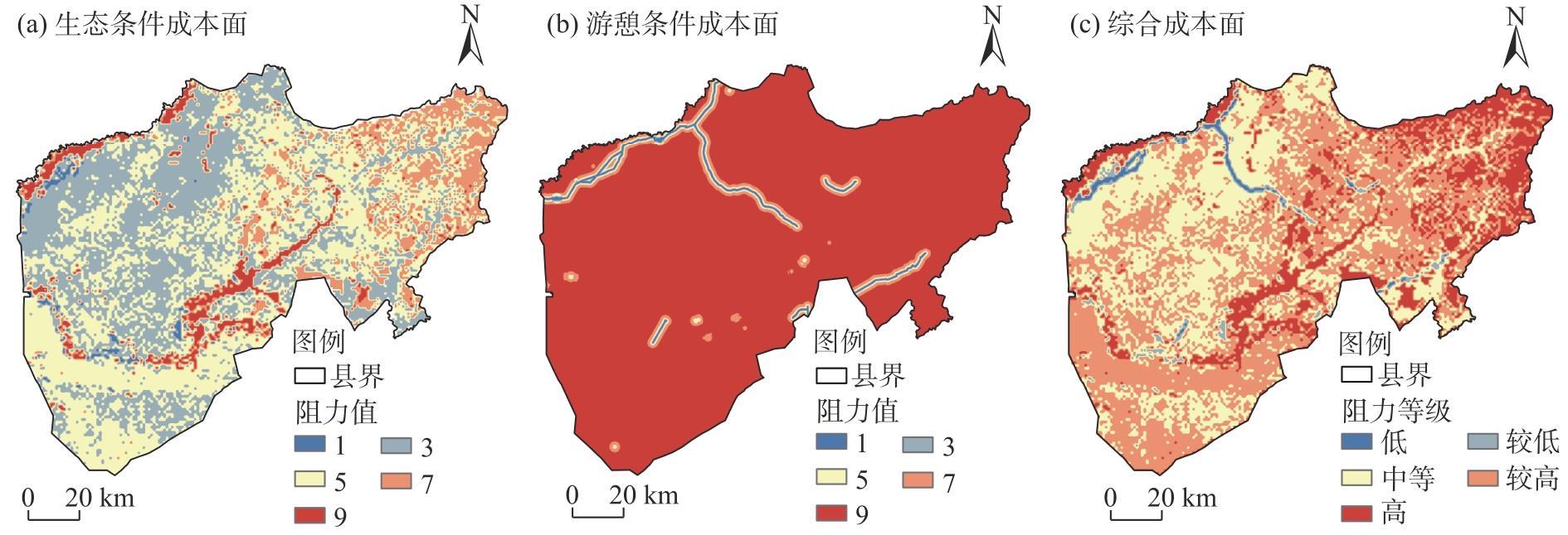
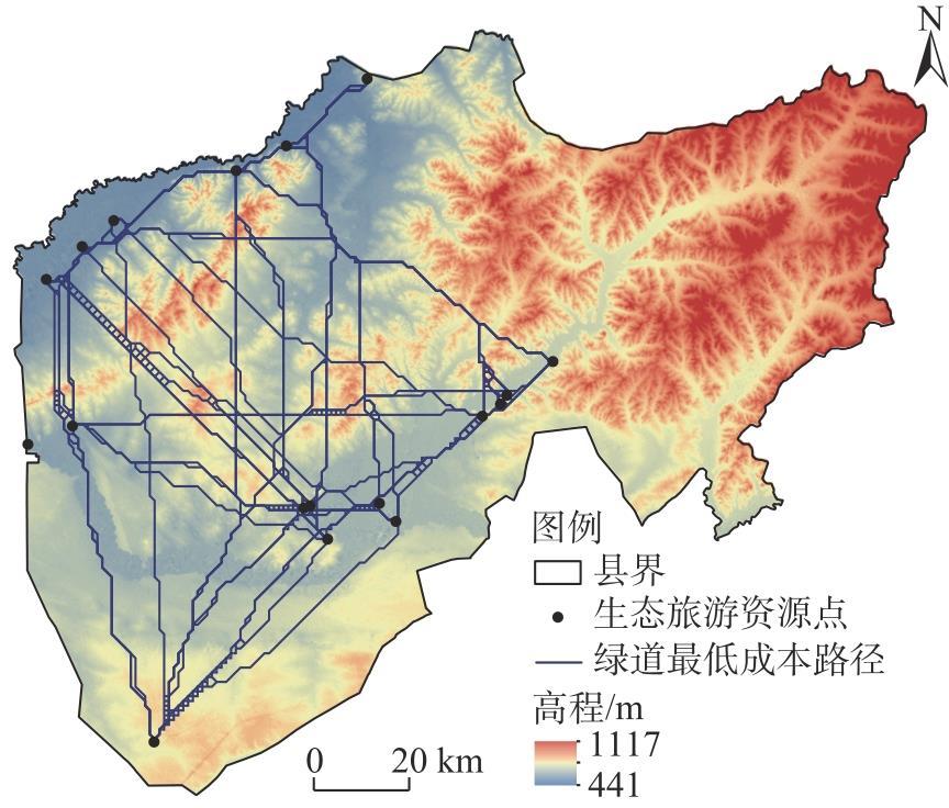
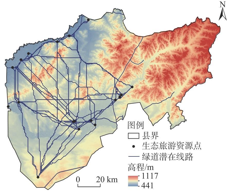
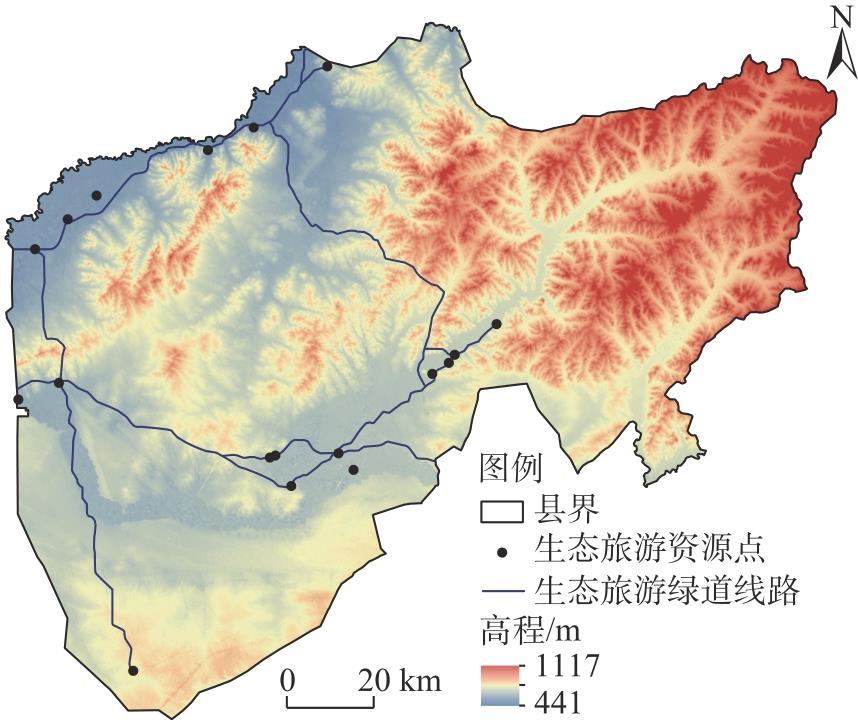
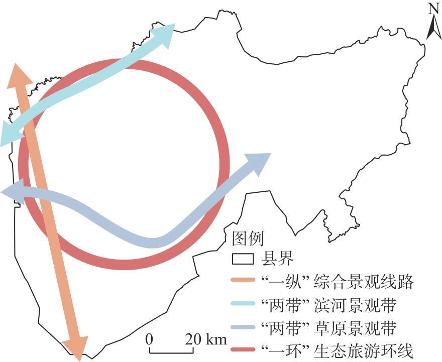
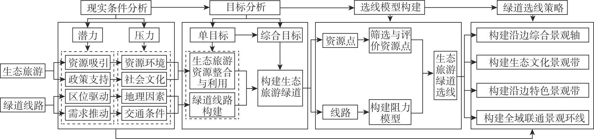
To facilitate the transformation of ecological resource advantages into economic benefits in the border areas of Inner Mongolia, China, this study focuses on Chen Barag Banner (County) and employs the minimum cumulative resistance model (MCR) to identify resistance surfaces, key areas, and potential routes for greenway construction. Addressing the challenges associated with integrating ecological resources, underdeveloped and unused landscapes along the border, and the lack of connectivity in open spaces, the study conducts an analysis and revision of data to determine organizational forms, such as connection relationships, radiation ranges, and spatial structures. An optimal path is then selected, leading to the development of a planning scheme for the Chen Barag Banner ecotourism greenway route. The findings reveal that: (1) The comprehensive resistance of Chen Barag Banner’s cost surface is currently high in the southeast and low in the northwest. Areas characterized by flat terrain, convenient transportation, and abundant ecological resources are more suitable for greenway construction. (2) By selecting routes that are proximate to river systems and resource points while optimizing for the lowest cost path, the attractiveness and utilization rate of greenways can be enhanced. Constructing greenway lines along existing road systems reduces construction complexity, minimizes ecosystem disruption, and aligns with user behavior patterns. (3) Implementing a ring layout improves resource connectivity by organizing dispersed ecotourism resources and extending their influence to surrounding areas, thereby fostering regional tourism development. Through the systematic analysis of ecotourism resources and potential routes, the study proposes a macro-level ecotourism greenway route selection scheme described as “one vertical, two belts, and one ring.” This approach establishes a mechanism for greenway route selection in border areas, offering a practical pathway for the integration of ecotourism resources and the development of greenway routes.
Mofei LIN , Hongyun JIAO , Zhen LI . Ecotourism greenway route selection in Inner Mongolia border area: A case of Chen Barag Banner[J]. Arid Land Geography, 2024 , 47(11) : 1970 -1980 . DOI: 10.12118/j.issn.1000-6060.2023.639
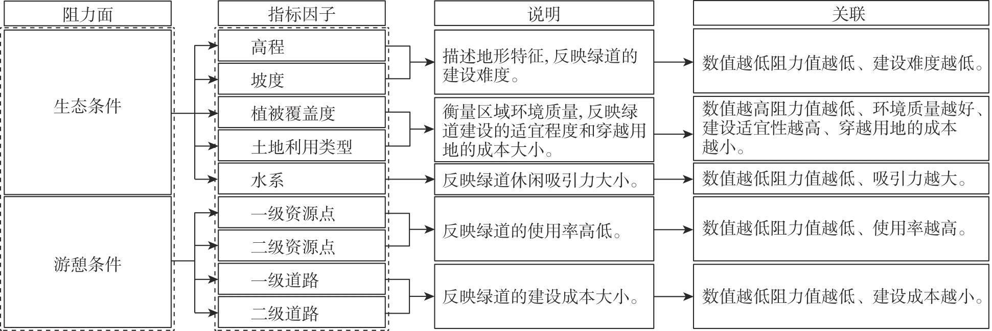
表1 生态条件分级赋值Tab. 1 Ecological condition classification and assignment |
| 阻力面 | 指标因子 | 分级标准 | 阻力值 |
|---|---|---|---|
| 生态条件 | 高程/m | 411~586 | 1 |
| 586~645 | 3 | ||
| 645~733 | 5 | ||
| 733~833 | 7 | ||
| 833~1117 | 9 | ||
| 坡度/(°) | <2.5 | 1 | |
| 2.5~8 | 3 | ||
| 8~15 | 5 | ||
| 15~25 | 7 | ||
| >25 | 9 | ||
| 植被覆盖度/% | <85 | 1 | |
| 70~85 | 3 | ||
| 50~70 | 5 | ||
| 25~50 | 7 | ||
| >25 | 9 | ||
| 土地利用类型 | 草地 | 1 | |
| 水、林地 | 3 | ||
| 耕地 | 5 | ||
| 建设用地 | 7 | ||
| 裸地 | 9 | ||
| 水系/m | 50 | 1 | |
| 50~100 | 3 | ||
| 100~250 | 5 | ||
| 250~500 | 7 | ||
| 500 | 9 |
注:高程因子的分级标准针对陈巴尔虎旗高程数据设定,其他因子的分级标准参考已有成果设定。 |
表2 游憩条件分级赋值Tab. 2 Recreation condition classification and assignment |
| 阻力面 | 指标因子 | 分级标准 | 阻力值 |
|---|---|---|---|
| 游憩条件 | 一级资源点/m | <800 | 1 |
| 800~1000 | 3 | ||
| 1000~2100 | 5 | ||
| 2100~3000 | 7 | ||
| >3000 | 9 | ||
| 二级资源点/m | <500 | 1 | |
| 500~800 | 3 | ||
| 800~1500 | 5 | ||
| 1500~2100 | 7 | ||
| >2100 | 9 | ||
| 一级道路/m | <500 | 1 | |
| 500~800 | 3 | ||
| 800~1500 | 5 | ||
| 1500~2100 | 7 | ||
| >2100 | 9 | ||
| 二级道路/m | <300 | 1 | |
| 300~500 | 3 | ||
| 500~1000 | 5 | ||
| 1000~2100 | 7 | ||
| >2100 | 9 |
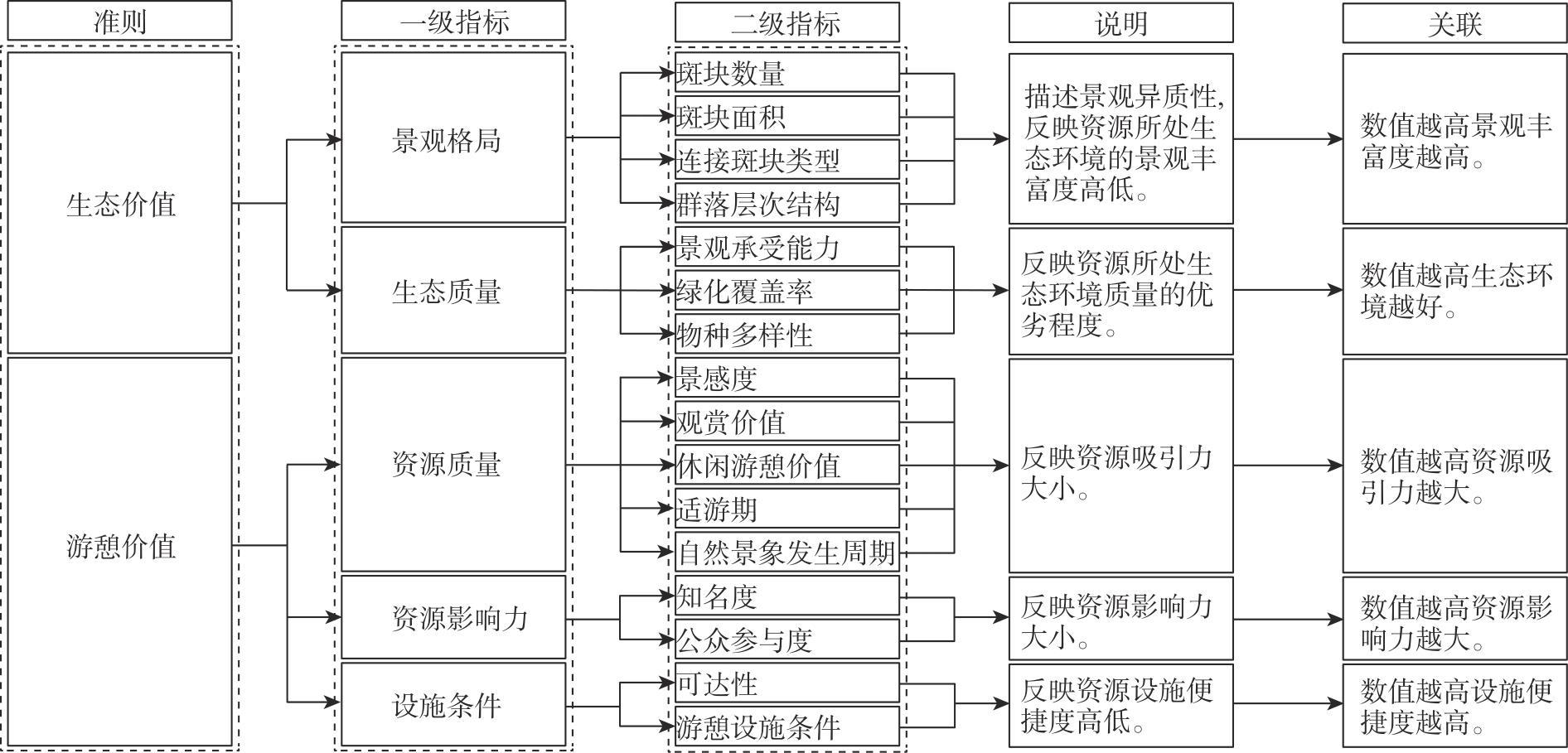
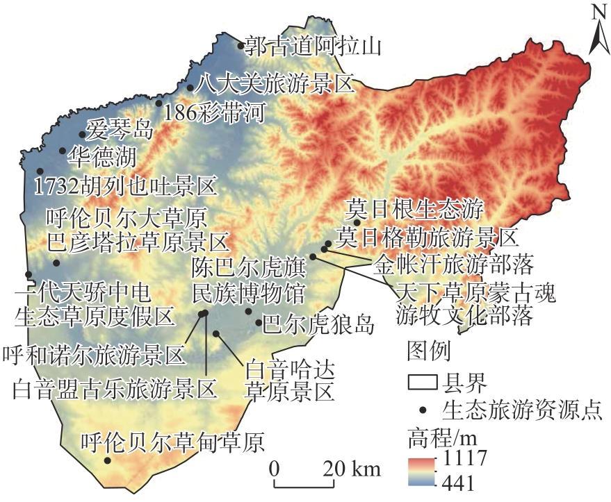
表3 生态旅游资源等级评价Tab. 3 Ecotourism resource grade evaluation |
| 序号 | 名称 | 权重 | 等级 |
|---|---|---|---|
| 1 | 1732胡列也吐景区 | 13.6 | 1 |
| 2 | 莫日格勒旅游景区 | 12.8 | 1 |
| 3 | 呼伦贝尔大草原巴彦塔拉草原景区 | 12.7 | 1 |
| 4 | 呼和诺尔旅游景区 | 10.7 | 1 |
| 5 | 186彩带河 | 10.4 | 1 |
| 6 | 郭古道阿拉山 | 8.5 | 2 |
| 7 | 呼伦贝尔草甸草原 | 6.1 | 2 |
| 8 | 白音哈达草原景区 | 5.0 | 2 |
| 9 | 金帐汗旅游部落 | 3.9 | 2 |
| 10 | 天下草原蒙古魂游牧文化部落 | 2.8 | 2 |
| 11 | 一代天骄中电生态草原度假区 | 2.5 | 2 |
| 12 | 莫日根生态游 | 2.1 | 2 |
| 13 | 白音盟古乐旅游景区 | 2.0 | 2 |
| 14 | 八大关旅游景区 | 1.6 | 2 |
| 15 | 华德湖 | 1.6 | 2 |
| 16 | 爱琴岛 | 1.5 | 2 |
| 17 | 陈巴尔虎旗民族博物馆 | 1.0 | 2 |
| 18 | 巴尔虎狼岛 | 0.8 | 2 |
表4 绿道选线阻力面权重Tab. 4 Weight of resistance surface for greenway selection |
| 阻力面 | 权重 | 指标因子 | 权重 |
|---|---|---|---|
| 生态条件 | 0.6 | 高程 | 0.12 |
| 坡度 | 0.20 | ||
| 植被覆盖度 | 0.13 | ||
| 土地利用类型 | 0.30 | ||
| 水系 | 0.25 | ||
| 游憩条件 | 0.4 | 一级资源点 | 0.45 |
| 二级资源点 | 0.25 | ||
| 一级道路 | 0.10 | ||
| 二级道路 | 0.20 |
| [1] |
陈田, 虞虎, 王甫园. 迈向可持续目标的中国生态旅游发展研究[J]. 中国生态旅游, 2021, 11(1): 78-94.
[
|
| [2] |
钟林生, 马向远, 曾瑜皙. 中国生态旅游研究进展与展望[J]. 地理科学进展, 2016, 35(6): 679-690.
[
|
| [3] |
胡剑双, 戴菲. 中国绿道研究进展[J]. 中国园林, 2010, 26(12): 88-93.
[
|
| [4] |
林墨飞, 王慧娴. 辽吉沿边地区生态旅游绿道规划研究[J]. 城市建筑, 2022, 19(15): 6-8, 29.
[
|
| [5] |
|
| [6] |
|
| [7] |
|
| [8] |
|
| [9] |
|
| [10] |
|
| [11] |
|
| [12] |
|
| [13] |
|
| [14] |
|
| [15] |
|
| [16] |
|
| [17] |
|
| [18] |
何昉. 中国绿道规划设计研究[D]. 北京: 北京林业大学, 2018.
[
|
| [19] |
董晓峰, 梁颖, 侯波, 等. 基于资源环境评价系统构建的京津冀城市群绿道选线研究[J]. 城市发展研究, 2021, 28(12): 118-127, 2.
[
|
| [20] |
王海珍, 张利权. 基于GIS景观格局和网络分析法的厦门本岛生态网络规划[J]. 植物生态学报, 2005, 29(1): 144-152.
[
|
| [21] |
黄浦江. 城市绿道网络识别、评价与优化[D]. 武汉: 武汉大学, 2014.
[
|
| [22] |
李海龙. 基于最小累积阻力模型的川西高原绿道游径系统线路规划方法研究——以康定市为例[J]. 城市发展研究, 2018, 25(11): 58-64.
[
|
| [23] |
刘铮, 王世福, 赵楠楠. 全球绿道运动中的中国实践: 理念思辨与理论展望[J]. 南方建筑, 2017(4): 23-29.
[
|
| [24] |
姚朋, 孙一豪, 奚秋蕙, 等. 耦合多元价值的生态风景道规划研究——以乌兰察布四横交通带风景道为例[J]. 中国园林, 2019, 35(4): 101-106.
[
|
| [25] |
丁纯璐, 马健霄, 朱宁. 基于层次分析法的城市绿道综合评价研究[J]. 森林工程, 2020, 36(2): 81-90.
[
|
| [26] |
李红, 刘伟平. 沿边地区开放平台及其经济效率时空演化分析[J]. 区域经济评论, 2023, 6: 102-110.
[
|
| [27] |
汪德根, 陆林, 陈田, 等. 我国边境省区入境客源市场结构及开发战略研究——以内蒙古自治区为例[J]. 干旱区地理, 2004, 27(4): 615-621.
[
|
| [28] |
杨蕾. 呼伦贝尔市旅游业发展中存在的问题及对策研究[D]. 哈尔滨: 哈尔滨工业大学, 2015.
[
|
| [29] |
邓晓娟, 李晶, 殷守强, 等. 陈巴尔虎旗土地生态状况评价及影响因素分析[J]. 中国农业大学学报, 2019, 24(11): 162-172.
[
|
| [30] |
周盼, 吴雪飞, 陶丹凤, 等. 基于多重目标的绿道选线规划研究——以草原丝绸之路(元上都至元中都段)文化线路为例[J]. 规划师, 2014, 30(8): 121-126.
[
|
| [31] |
汪民, 贾建玲, 张俊磊. 基于适宜性评价的厦门市海沧区绿道选线规划[J]. 华中建筑, 2015, 33(10): 83-89.
[
|
| [32] |
李洪庆, 杨瑀, 张俊红. 雅鲁藏布江山南宽谷流域生态安全格局构建[J]. 干旱区地理, 2023, 46(9): 1503-1513.
[
|
| [33] |
李伊彤, 荣丽华, 李文龙, 等. 生态重要性视角下东北林区县域生态安全格局研究——以呼伦贝尔市阿荣旗为例[J]. 干旱区地理, 2022, 45(5): 1615-1625.
[
|
| [34] |
张玮. 基于最小累积阻力模型的绿道选线研究[D]. 太原: 山西农业大学, 2017.
[
|
| [35] |
|
/
| 〈 |
|
〉 |